We may have changed the calendar to March but it seems like we are receiving weather more common for January. The bone-chilling cold of recent weeks has continued and the Mile High City set two temperature records in as many days.
Yesterday, as measured at Denver International Airport, the Mile High City saw a high temperature of only 6 degrees. This easily broke the record for the coldest maximum (high) temperature for March 3rd. The previous record was 14 degrees set in 1978.
Thornton was slightly warmer yesterday with a high of 8 degrees.
Also of note, yesterday’s low temperature reading in Denver of -6 degrees, while not a record low for the date, was the coldest temperature reading in March since -7 degrees was recorded on March 2, 1960.
This morning, the mercury at DIA dropped to -5 degrees. That bested the record low temperature for March 4th of -3 degrees last set in 1978. Similarly, Thornton saw a low of -5 degrees.
Warmer weather is on its way but the warm up will be slow as the Arctic air and snow cover lingers. For what lies ahead, see the extended weather forecast here.
The month of March in Denver is usually one that is welcomed heartily by residents. We begin to shake off the cold of winter with warmer temperatures and calmer conditions. That does not mean we are done with snow and cold by any means.
March usually offers healthy snowfall giving us an opportunity to add to our seasonal totals. While there is good snow potential in March, the month also typically brings much warmer temperatures.
March is historically Denver’s snowiest month and brings about 20% of our annual snowfall. Heavy, wet spring snow storms can oftentimes bring the entire month’s snowfall total in one monstrous snow.
We also start the transition to spring and severe weather season and the month typically brings our first thunderstorms of the year. Temperatures climb throughout the month and by the end our average daytime highs are near 60 degrees.
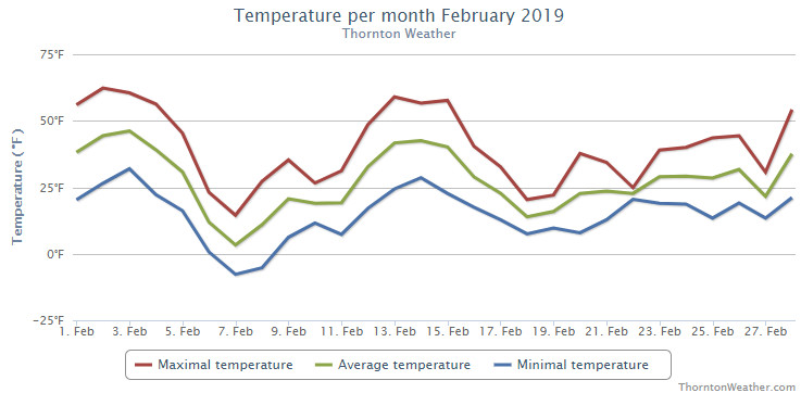
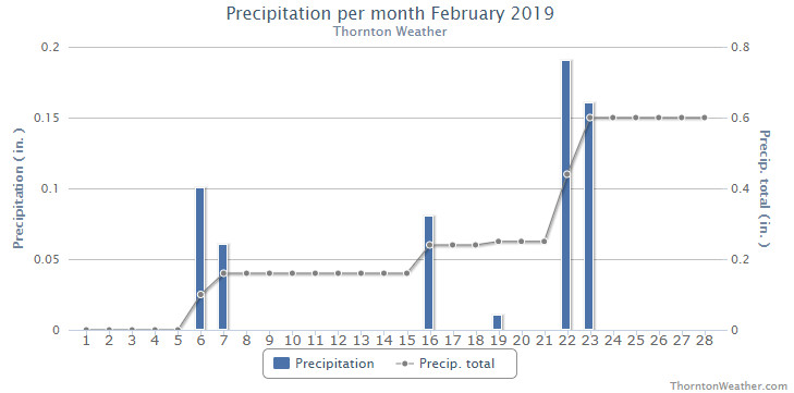
Cold and snow. Those were certainly the operative words for the month of February 19. Thornton recorded its coldest February in the past 12 years and its snowiest month overall since March 2016.
Mild temperatures started things off for the first four days of the month and fooled us into thinking of an early spring. Those dreams were soon crushed though as the first extended period of below normal temperatures arrived on the 6th. Six straight days of below normal temperatures then arrived as did our first shot of snow for the month.
We rebounded briefly for a four day period from the 12th to the 15th with mild temperatures. Once again though, the mercury plunged delivering 13 straight days of below normal temperatures and five days of measurable snowfall.
Thornton recorded an average temperature for the month of 26.3 degrees. This was our coldest February since ThorntonWeather.com came online in 2007 – by more than two degrees. Out at Denver International Airport where the Mile High City’s official readings are taken it was slightly warmer with an average of 28.0 degrees. Both were well below Denver’s long term February average of 32.5 degrees for February.
While certainly cold, neither average reading for the month could crack Denver’s list of top 10 coldest Februarys.
Thornton saw its warmest mercury reading for the month of 62.3 degrees on the second. Its coldest reading of -7.7 degrees came on the 7th of the month. Denver saw a maximum of 65 degrees on the 3rd and its low of -11 degrees on the 7th.
February is usually a dry month with Denver averaging 0.37 inches of liquid precipitation. Thornton recorded 0.60 inches this year while Denver saw 0.72 inches.
Similarly, snow was a good bit above normal for February as well. Thornton saw 11.2 inches of the white stuff while out at the airport 13.4 inches was recorded.
Thornton, Colorado’s temperature summary for February 2019. (ThorntonWeather.com)Thornton, Colorado’s precipitation summary for February 2019. (ThorntonWeather.com)
CLIMATE REPORT
NATIONAL WEATHER SERVICE DENVER/BOULDER CO
555 AM MST FRI MAR 1 2019

...................................

...THE DENVER CO CLIMATE SUMMARY FOR THE MONTH OF FEBRUARY 2019...

CLIMATE NORMAL PERIOD 1981 TO 2010
CLIMATE RECORD PERIOD 1872 TO 2019

WEATHER         OBSERVED          NORMAL  DEPART  LAST YEAR`S
                 VALUE   DATE(S)  VALUE   FROM    VALUE  DATE(S)
                                          NORMAL
................................................................
TEMPERATURE (F)
RECORD
 HIGH              80   02/10/2017
 LOW              -25   02/01/1951
                        02/08/1936
HIGHEST            65   02/03
LOWEST            -11   02/07
AVG. MAXIMUM     40.8              46.2    -5.4     44.4
AVG. MINIMUM     15.3              18.9    -3.6     15.4
MEAN             28.0              32.5    -4.5     29.9
DAYS MAX >= 90      0               0.0     0.0        0
DAYS MAX <= 32      8               3.9     4.1        6
DAYS MIN <= 32     26              26.9    -0.9       26
DAYS MIN <= 0       3               1.3     1.7        3

PRECIPITATION (INCHES)
RECORD
 MAXIMUM         2.01   1934
 MINIMUM         0.01   1970
TOTALS           0.72              0.37    0.35     0.31
DAILY AVG.       0.03              0.01    0.02     0.01
DAYS >= .01         6               5.3     0.7        5
DAYS >= .10         3               0.7     2.3        2
DAYS >= .50         0               0.0     0.0        0
DAYS >= 1.00        0               0.0     0.0        0
GREATEST
 24 HR. TOTAL    0.41   02/22

             OBSERVED            NORMAL   DEPART   LAST YEAR`S
SNOWFALL (INCHES)
TOTAL            13.4               5.7      7.7     6.2
RECORD FEB       22.4   2015
SEASON TOTAL     27.8              35.2

DEGREE_DAYS
HEATING TOTAL    1029               908     121      975
 SINCE 7/1       4417              4439     -22     4057
COOLING TOTAL       0                 0       0        0
 SINCE 1/1          0                 0       0        0

FREEZE DATES
RECORD
 EARLIEST     09/08/1962
 LATEST       06/08/2007
EARLIEST                        10/07
LATEST                          05/05
.................................................................

WIND (MPH)
AVERAGE WIND SPEED              9.5
RESULTANT WIND SPEED/DIRECTION   1/176
HIGHEST WIND SPEED/DIRECTION    35/060    DATE  02/14
HIGHEST GUST SPEED/DIRECTION    42/070    DATE  02/14

SKY COVER
POSSIBLE SUNSHINE (PERCENT)   MM
AVERAGE SKY COVER           0.60
NUMBER OF DAYS FAIR            3
NUMBER OF DAYS PC             20
NUMBER OF DAYS CLOUDY          5

AVERAGE RH (PERCENT)     66

WEATHER CONDITIONS. NUMBER OF DAYS WITH
THUNDER        0   FREEZING RAIN    0      LIGHT SNOW    14
MIXED PRECIP   0   LGT FR RAIN      0      ICE PELLETS    0
HEAVY RAIN     0   HAIL             0      FOG           17
RAIN           0   HEAVY SNOW       2      HEAVY FOG     11
LIGHT RAIN     0   MODERATE SNOW    3      HAZE           8

-  INDICATES NEGATIVE NUMBERS.
R  INDICATES RECORD WAS SET OR TIED.
MM INDICATES DATA IS MISSING.
T  INDICATES TRACE AMOUNT.
February 4, 2019 – A bison and bird boop noses on a mild winter day. (Jessica Fey)
February signifies the start of the climb toward warmer temperatures for the year. Cold and snow though do intrude but, coupled with milder conditions, there are lots of photo opportunities as can be seen in our monthly slideshow.
The month is one of our least snowiest of the year but it isn’t unusual to see the landscape blanketed in white. Warming temperatures through the month can bring the onset of spring fever and gives residents the opportunity to enjoy some prolonged time outdoors on the mild days.
Cold or mild, snowy or dry, our scenery is almost always gorgeous – and photo worthy.
Slideshow updated February 27, 2019
To learn more about how to send your photo to us for inclusion in the slideshow, see below the slideshow.
Showcasing images captured by ThorntonWeather.com readers as well as some of our own, our monthly slideshow covers the entire gamut of weather-related imagery.
Sunsets, sunrises, wildlife and of course every type of weather condition are vividly depicted in images captured from yours and our cameras.
[flickr_set id=”72157676280611747″]
What is missing in the slideshow above? Your photo!
Our monthly photo slideshow is going to feature images that we have taken but more importantly images that you have captured. The photos can be of anything even remotely weather-related.
Landscapes, current conditions, wildlife, pets, kids. Whimsical, newsy, artsy. Taken at the zoo, some other area attraction, a local park, a national park or your backyard. You name it, we want to see and share it!
Images can be taken in Thornton, Denver or anywhere across the extraordinary Centennial State. We’ll even take some from out of state if we can tie it to Colorado somehow.
We’ll keep the criteria very open to interpretation with just about any image eligible to be shown in our slideshows.
What do you win for having your image in our slideshow? We are just a ‘mom and pop’ outfit and make no money from our site so we really don’t have the means to provide prizes. However you will have our undying gratitude and the satisfaction that your images are shared on the most popular website in Thornton.
To share you images with us and get them included in the slideshow just email them to us or share them with ThorntonWeather.com on any of the various social media outlets. Links are provided below.
February 24 to March 2: This Week in Denver Weather History
As February comes to a close, one of our snowiest months, March, is ahead. Our look back at this week in Denver weather history shows there have indeed been some significant snowfalls as well as high wind events.
From the National Weather Service:
22-29
In 1960…heavy snowfall of 6.1 inches at Stapleton Airport on the 22nd and 23rd marked the beginning of a protracted cold spell which lasted until the end of the month. The cloudy… Cold weather was accompanied by occasional light snow or flurries and fog. New record low temperatures for the dates were set on the 24th thru the 29th with the lowest temperature of 11 degrees below zero on the 28th. The seven consecutive days of low temperatures of zero or below had been exceeded in duration only 4 times previously. New low maximum temperatures for the dates were set on the 23rd… 24th…and the 26th thru the 29th with the lowest maximum temperature of 8 degrees recorded on the 26th.
23-24
In 1935…northwest winds sustained to 37 mph with gusts as high as 47 mph produced considerable blowing dust behind a cold front on the 23rd. The dust was dampened by 7.0 inches of snowfall over downtown Denver from the late evening of the 23rd through the evening of the 24th.
In 1997…heavy snow fell in the foothills. Snowfall totals included 8 inches at sunshine canyon northwest of Boulder… And 6 inches at Morrison. Snowfall totaled only 2.4 inches at the site of the former Stapleton International Airport. East winds gusted to only 22 mph at Denver International Airport on the 23rd.
23-25
In 1912…a severe winter storm dumped 14.2 inches of snowfall over downtown Denver. Snow fell continuously from 9:40 am on the 23rd until 9:15 pm on the 25th with most of the snow… 9.2 inches…on the 24th. Temperatures were mostly in the 20’s. Northeast winds were sustained to 20 mph on the 24th.
24
In 1908…a duststorm occured in the city from mid-morning through mid-day. North winds were sustained from 30 to 35 mph.
In 1927…northwest winds were sustained to 42 mph with an extreme velocity to 46 mph.
In 1924…fog deposited a light coating of glaze…which was very thin and only accumulated on the windward side of cold objects. Streets and sidewalks became slippery.
In 1956…a strong cold front produced north wind gusts to 54 mph…but left only 2.0 inches of snowfall at Stapleton Airport.
In 1959…heavy snowfall totaled 7.5 inches at Stapleton Airport…where north-northeast winds gusted to only 18 mph.
In 1968…west-northwest winds gusted to 49 mph at Stapleton International Airport. The strong Chinook winds warmed the maximum temperature to 61 degrees…the highest temperature of the month that year.
In 1986…wind gusts to 65 mph were reported at Table Mesa in Boulder. West winds gusted to only 28 mph at Stapleton International Airport where the high temperature of 70 degrees equaled the record for the date.
In 1991…the only measurable snowfall for the month totaled only 0.8 inch at Stapleton International Airport where north winds gusted to 28 mph. The light snow fell for most of the day.
In 1994…high winds raked the eastern foothills. Wind speeds of 70 to 80 mph were common. Wind gusts to 110 mph were recorded at the National Center for Atmospheric Research in south Boulder…while in north Boulder winds gusted to 95 mph. The strong winds blew the roof off a building at red rocks community college in Lakewood…causing the evacuation of about 1500 people. A semi-trailer and a delivery truck were overturned. In Lakewood…a home under construction was destroyed by the winds. There were numerous reports of vehicles damaged by flying debris…and many automobile windshields were shattered. West wind gusts to 47 mph were recorded at Stapleton International Airport.
In 2013…A storm system near the Four Corners region produced heavy upslope snowfall in and near the Front Range with blizzard conditions further east as it made its way across southern Colorado. In the Front Range Mountains and Foothills storm totals included: 27 inches near Pinecliffe; 24 inches…13 miles northwest of Golden; 20 inches near Genesee; 17 inches near Conifer; 15 inches near Jamestown; 14 inches…just southwest of Eldorado Springs; 12.5 inches near Aspen Springs; 12 inches near Evergreen and Ward; 10 inches at Eldora Ski Area; with 8 inches near Gross Reservoir…Idaho Springs and Nederland. Across the Urban Corridor storm totals included: 12 inches in Aurora; 11.5 inches near Highlands Ranch; 11 inches in Lakewood; 10.5 inches just north of Longmont and Westminster; 10 inches in Lone Tree and Thornton; 8.5 inches in Aurora…6 miles southwest of Denver and near Loveland; 8 inches at Boulder… Broomfield…and Ralston Reservoir; 7.5 inches near Frederick…with 7 inches at Commerce City. The storm prompted the cancellation of 200 flights in and out of Denver International Airport. Officially…the storm system produced 9.1 inches of snow at DIA which established a new daily snowfall record in Denver for the date. Along and south of the I-70 corridor and east of Denver…the combination of heavy snow and strong wind produced blizzard conditions. Storm totals included: 14 inches…10 miles south-southeast of Buckley AFB…10.5 inches…8 miles southeast of Watkins; with 6 inches near Byers. Northerly winds of 25 to 30 mph were common with gusts to 40 mph. At DIA…a peak wind gust of 32 mph was observed.
25
In 1887…northwest winds were sustained to 47 mph.
In 1904…the low temperature cooled to only 49 degrees…the all-time record high minimum temperature for February.
In 1957…north winds gusted to 49 mph at Stapleton Airport.
In 1998…a bora wind storm developed in the Front Range foothills and adjacent plains as winds gusted between 60 and 75 mph. Peak wind gusts during the storm included: 75 mph atop Blue Mountain near Wondervu…60 mph in south Boulder and at Jefferson County Airport near Broomfield. West winds gusted to 32 mph at Denver International Airport.
In 2000…high winds occurred in and near the foothills. Winds gusted to 84 mph at the Rocky Flats Environmental Test Facility south of Boulder and to 71 mph atop Niwot Ridge in the mountains west of Boulder. West winds gusted to only 36 mph at Denver International Airport.
25-26
In 1971…a wind gust to 100 mph was recorded in Boulder at the National Center for Atmospheric Research. The cold west winds gusted to 53 mph in downtown Boulder. No damage was reported. Northwest winds gusted to 31 mph on the 25th and to 38 mph on the 26th at Stapleton International Airport.
In 1984…a heavy snow storm left 1 to 2 feet of new snow in the foothills west of Denver. I-70 was closed…stranding skiers returning from the mountains. Most had to spend several hours in Idaho Springs. The snow spread over metro Denver with 9 inches at Littleton…Castle Rock…and Boulder and up to 5 inches in Aurora and Denver. Snowfall totaled only 3.6 inches at Stapleton International Airport where north winds gusted to 31 mph.
26
In 1884…heavy snowfall totaled 6.0 inches in downtown Denver.
In 1908…a duststorm occurred in the city during the afternoon. Northwest winds were sustained from 14 to 24 mph.
In 1918…pre-frontal Chinook winds from the southwest… Sustained to 43 mph with a maximum velocity to 52 mph… Warmed temperatures to a high of 62 degrees.
In 1954…strong Chinook winds gusting to 52 mph during the morning warmed the temperature in Denver to a balmy 65 degrees by early afternoon. A vigorous Canadian cold front during the late afternoon produced north winds at sustained speeds of 52 mph with gusts as high as 65 mph and billows of blowing dust…which reduced the visibility to as low as 1 mile at Stapleton Airport. Showers left half an inch of snow on the ground as the temperature dipped to a low of 27 degrees before midnight.
In 1989…a brief rain shower produced a microburst wind gust to 51 mph at Stapleton International Airport.
In 1997…snowfall totaled 4 to 6 inches in and near the foothills. Only 0.8 inch of snow fell at the site of the former Stapleton International Airport. Northeast winds gusted to 29 mph at Denver International Airport.
In 2013…a storm system produced heavy snow in the Front Range Foothills. Storm totals included: 12 inches near Black Mountain and Pine Junction…10 inches near Conifer and Nederland; 9 inches…12 miles northwest of Golden; 8 inches near Evergreen…with 6 inches near Eldorado Springs. Snow and blowing snow produced blizzard conditions along and south of the Interstate 70 corridor…just east of Denver. Storm totals generally ranged from 3 to 7 inches. North winds of 25 to 30 mph were reported with gusts around 40 mph. Roads became impassable as snow and blowing snow produced 3 to 4 ft snow drifts. Interstate 70 was closed from Aurora to the Kansas state line. At Denver International Airport…a peak wind gust to 31 mph was reported along with 1.0 inch of snow.
February 17 to February 23: This Week in Denver Weather History
Staying true to its reputation as a relatively dry month, our look back at this week in Denver weather history doesn’t contain much in the way of snow. What it does have an abundance of however are powerful, damaging wind events.
From the National Weather Service:
15-17
In 1938…a cold air mass brought a light snowfall of 6.2 inches over 3 days to downtown Denver where northeast winds were sustained to 18 mph on the 15th.
16-17 in 1929…strong west winds gusting to 84 mph raked Boulder and Lafayette. Limited minor damage and a few injuries occurred.
In 1986…strong Chinook winds continued to howl in the foothills. A wind gust to 89 mph was recorded at Table Mesa in Boulder on the 16th. Winds of 60 to 75 mph were clocked at other locations in Boulder on both days. A west wind gust to 51 mph was recorded at Stapleton International Airport on the 16th.
16-17
In 1929…strong west winds gusting to 84 mph raked Boulder and Lafayette. Limited minor damage and a few injuries occurred.
In 1986…strong chinook winds continued to howl in the foothills. A wind gust to 89 mph was recorded at Table Mesa in Boulder on the 16th. Winds of 60 to 75 mph were clocked at other locations in Boulder on both days. A west wind gust to 51 mph was recorded at Stapleton International Airport on the 16th.
In 2014…high winds developed briefly overnight in and near the foothills of Boulder and Jefferson Counties. Peak wind reports included: 98 mph…4 miles north-northwest of White Ranch Open Space; 85 mph at the NCAR Mesa Lab; 78 mph at the Junction of Colorado Highways 93 and 172; and 75 mph just southeast of Morrison. A semi-truck and an SUV pulling a trailer were rolled over by the wind on Colorado 470 near Morrison. Strong winds damaged a home under construction in Lakewood.
16-18
In 1970…a wind gust to 90 mph was recorded in Boulder at the National Center for Atmospheric Research. In downtown Boulder…sustained winds of 30 to 40 mph with gusts to 53 mph were measured. Damage was minor. West winds gusted to 45 mph at Stapleton International Airport on the 17th. The strong Chinook winds warmed the temperature to 70 degrees on the 16th and to 72 degrees on the 17th…both records for the date. The low temperature dipped to only 32 degrees on the 16th equaling the record high minimum for the date.
17
In 1887…west winds were sustained to 64 mph. Strong winds occurred all day long in the city. Rainfall was 0.02 inch.
In 1894…northwest winds were sustained to 40 mph with gusts to 46 mph.
In 1937…northwest winds sustained to 36 mph with gusts to 44 mph started a few minor fires and broke a number of plate-glass windows in downtown Denver office buildings.
In 1962…heavy snowfall totaled 7.5 inches at Stapleton Airport where the visibility was reduced to as low as 1/4 mile at times. Winds gusted from the northeast at only 15 mph.
In 2009…strong prefrontal wind gusts knocked down some trees and power lines in Boulder. More than 3400 Xcel customers in the University Hill area were without power for about one hour. Peak wind gusts included 68 mph at the NCAR Mesa Lab and 60 mph in Boulder.
17-18
In 1976…a strong cold front produced wind gusts 30 to 60 mph with much blowing snow and severe dust storms. In the Boulder area…high winds collapsed a garage and broke some windows. Northwest winds gusted to 43 mph on the 17th and to 44 mph on the 18th at Stapleton International Airport.
In 1984…the third blizzard in a week struck eastern Colorado. Heavy snow hit some parts of metro Denver with 8 to 10 inches measured in Aurora…but only 2.9 inches of snow fell at Stapleton International Airport where northwest winds gusted to 31 mph.
In 1999…damaging downslope bora winds developed in the foothills behind a strong cold front. Peak wind reports included: 90 mph at the Gamow Tower on the University of Colorado campus in Boulder; 79 mph at the National Center for Atmospheric Research mesa lab near Boulder and at the national wind technology center south of Boulder; and 72 mph atop Blue Mountain and at Jefferson County Airport. Downed power lines caused major outages for at least 10 thousand residents in Evergreen…Idaho Springs…Golden… And Lakewood. In Golden…the wind toppled a lightning static protection line atop a 70-foot…230 thousand-volt distribution tower. The downed line…sparked a small grass fire just east of the Lookout Mountain youth services center. The fire burned a path approximately 100 yards wide and 1/3 mile long before it was contained.
In 2000…snow…heavy in the mountains and foothills…spread over metro Denver. Snowfall totaled 24 inches at the Eldora Ski Resort with 8 inches measured near Blackhawk. Snowfall was only 1.8 inches at the site of the former Stapleton International Airport…which was the only measurable snow of the month.
17-19
In 2006…a cold spell resulted in 4 temperature records. Low temperatures of 10 degrees below zero on the 17th… 13 degrees below zero on the 18th…and 4 degrees below zero on the 19th were record minimums for those dates. The high temperature of only 7 degrees on the 18th was a record low maximum for the date. Light snow fell on the 17th…but totaled less than half an inch at Denver International Airport.
18
In 1918…post-frontal northwest winds were sustained to 40 mph with a measured extreme velocity to 44 mph.
In 1937…a moderate duststorm occurred during the late afternoon and early evening. Northeast winds sustained to 32 mph with gusts to 41 mph reduced the visibility to 1/2 mile which persisted for about 40 minutes in the city.
In 1998…rare thunder from instability rain and snow showers was heard in Littleton during the late afternoon. Thunder in February only occurs about once every 10 years over metro Denver.
18-19
In 1954…a vigorous cold front produced north winds gusting to 56 mph and a trace of snowfall at Stapleton Airport on the 18th. Strong and gusty winds to 55 mph persisted through the next day and caused some blowing dust.
In 1955…a storm dumped heavy snow across metro Denver. At Stapleton Airport where north winds sustained to 28 mph produced some blowing snow…snowfall totaled 8.8 inches.
18-20
In 1913…post-frontal snowfall totaled 6.9 inches in downtown Denver over the 3 days. Most of the snow fell on the 19th. Northeast winds were sustained to 21 mph with a measured extreme velocity to 24 mph on the 18th.
In 1924…light snowfall totaled 4.6 inches over the 3 days. This was the only measurable snowfall of the month. High temperatures plunged from 45 degrees on the 18th to 17 degrees on the 20th. Low temperatures dipped from 31 degrees on the 18th to only 8 degrees on the 20th. Northeast winds were sustained to 24 mph on the 19th.
In 1953…a major blizzard dumped 10.6 inches of snowfall at Stapleton Airport. Strong north winds at sustained speeds of 25 to 35 mph with gusts as high as 44 mph frequently reduced visibilities to 1/4 mile in blowing snow during the day of the 19th. The strong winds caused much drifting snow…making accurate snowfall measurements almost impossible. Precipitation from the storm totaled 1.13 inches. The 1.01 inches of precipitation on the 19th was the greatest calendar day and 24 hour precipitation ever recorded in the city during the month of February.
In 1987…large amounts of new snow fell in the Front Range foothills. The foothills received 10 to 20 inches of new snow with 4 to 8 inches on the adjacent plains. On the 19th…flight delays occurred at Stapleton International Airport where snowfall totaled 4.2 inches and east winds gusted to only 18 mph on the 19th. Schools were closed in the foothills above Boulder.
19
In 1899…northwest winds sustained to 42 mph with gusts to 45 mph warmed the temperature to a high of 56 degrees… The highest reading of the month that year.
In 1980…high winds were reported in Boulder. Sustained speeds of 50 to 60 mph with gusts to 85 mph were measured. West winds gusted to 31 mph at Stapleton International Airport.
In 1986…Chinook winds continued to buffet the eastern foothills. Winds gusting from 60 to 75 mph were common in the foothills. West winds gusted to 41 mph at Stapleton International Airport.
In 1996…high winds gusting from 70 to 75 mph were reported atop Table Mesa near Boulder. West winds gusted to 44 mph at Denver International Airport.
In 2007…this was the last day of 61 consecutive days with snow cover of 1 inch or more in Denver. This second longest period of snow cover on record began with the blizzard on December 20-21…2006…when 20.7 inches of snow fell at the site of the former Stapleton International Airport where official snow measurements were taken. Additional snowfall during December…January…and February prolonged the event. Snow depth on the ground was measured to the nearest inch once daily at 6:00 am MST.
February 10 to February 16: This Week in Denver Weather History
As we continue a dry winter, we look to history to provide some sort of hope. While there have been some significant snow events this week in Denver weather history, more common is bitter cold and damaging winds.
From the National Weather Service:
15-23
In 1962…a protracted cold spell kept metro Denver in the deep freeze for more than a week. From the 15th thru the 23rd…low temperatures were zero or below for 9 consecutive days…but a daily record low was set only on the 22nd when the temperature dipped to 14 degrees below zero. A record low maximum for the date was also set on the 22nd when the temperature climbed to only 11 degrees. The coldest high temperature was 3 degrees above zero on the 21st…which did not break the record. The protracted cold was broken for only a few hours on the afternoon of the 20th when Chinook winds warmed the temperature to a high of 38 degrees before another surge of cold arctic air plunged temperatures back into the deep freeze that evening. The severe cold caused much damage to water systems. A woman was frozen to death at Morrison. There were other deaths attributable to the weather…including traffic deaths and heart attacks from overexertion.
16
In 1911…a trace of rain fell…a rare event in January.
In 1935…rainfall was 0.01 inch during the afternoon…a rare event in January.
In 1989…wind gusts to 80 mph were reported in southwest Boulder. Winds reached 100 mph at Rollinsville in the foothills southwest of Boulder.
In Golden…the wind blew a 25-foot trailer through a fence and flipped it over. West winds gusted to 37 mph at Stapleton International Airport where the Chinook winds warmed the temperature to a high of 49 degrees.
16-17
In 1886…a brief cold spell resulted in two temperature records. High temperatures of zero degrees on the 16th and 2 degrees below zero on the 17th were both record low maximums for the dates. Low temperatures of 8 degrees below zero on the 16th and 16 degrees below zero on the 17th were not records.
In 1930…temperatures plunging well below zero resulted in two records. Low temperatures of 19 degrees below zero on the 16th and 20 degrees below zero on the 17th were record low temperatures for the dates. High temperatures were 4 degrees on the 16th and 15 degrees on the 17th. Light snowfall totaled 4.0 inches. North winds were sustained to 18 mph on the 16th.
In 1964…high winds struck the eastern foothills. Gale velocity winds were recorded in Boulder with gusts to 83 mph measured at Rocky Flats. Several airplanes were damaged at the Jefferson County Airport in Broomfield. Roofs…walls…and parts of buildings were blown away at various locations. Power poles and trees were blown over.
16-18
In 1943…light snowfall totaled 3.2 inches over the 3 days. This was the only measurable snow of the month. North winds were sustained to 20 mph on the 16th.
In 2011…very strong winds associated with an upper level jetstream over Colorado produced blizzard conditions in the mountains above timberline. Peak wind gusts included: 99 mph atop Loveland pass…94 mph…2 miles southwest of Mary Jane…80 mph atop Berthoud Pass and 79 mph atop Niwot Ridge. Storm totals in the ski areas west of Denver ranged from 8 to 14 inches.
5-11
In 1978…the 5th marked the start of a record 7 consecutive days of dense fog at Stapleton International Airport. The heavy fog reduced the visibility to 1/4 mile or less for a period of time on each of these days. Light snow and/or freezing drizzle occurred on most days. Fog reducing visibility to less than 7 miles was recorded at Stapleton International Airport on 11 consecutive days through the 15th. During the period 5-14…the cold thick fog deposited heavy rime ice up to 5 inches thick on power lines and poles over a wide area of eastern Colorado…causing a major electrical power outage disaster.
6-10
In 1933…3:00 pm on the 6th marked the start of a protracted cold period through 8:00 am on the 10th when the temperature was below zero for 86 out of 88 hours. The cold period was interrupted on the 8th at 9:00 am when the temperature was 1 degree above zero and at 10:00 am when the temperature was 8 degrees above zero. Four temperature records were set. High temperatures of 4 degrees below zero on the 7th…8 degrees on the 8th…and 5 degrees below zero on the 9th were record low maximums for those dates. The only record low temperature record was 14 degrees below zero on the 10th. The lowest temperature reached during the period was 16 degrees below zero on both the 7th and 8th…which were not records.
9-10
In 1934…rain changed to heavy snow on the afternoon of the 9th and continued through the day on the 10th. Snowfall totaled 7.4 inches in downtown Denver. North winds were sustained to 24 mph on the 10th.
In 1972…heavy post-frontal snowfall totaled 6.2 inches at Stapleton International Airport where northeast winds gusted to 46 mph on the 9th. Temperatures plunged from a high of 51 degrees on the 9th to a low of 16 on the morning of the 10th.
In 1981…the season’s coldest arctic air mass rolled into metro Denver plunging temperatures from 10 below to 20 degrees below zero. Bitter north winds gusting as high as 36 mph sent wind chill temperatures to 50 below zero. Two to four inches of snow fell over metro Denver with 6 to 12 inches in the foothills. A Boulder man died of hypothermia while cross country skiing in the mountains west of the city. Snowfall totaled only 1.5 inches at Stapleton International Airport where the minimum temperature on the morning of the 10th was 5 degrees below zero. The temperature that day warmed to a high of only 9 degrees.
In 2003…high winds occurred in and near the eastern foothills. The highest wind gusts recorded: Included 80 mph atop Fritz Peak and 73 mph atop Blue Mountain and at the national wind technology center on Rocky Flats south of Boulder. At least 4 multi-car accidents occurred along State Highway 93…between Golden and Boulder when blowing snow caused whiteout conditions. Northwest winds gusted to 36 mph at Denver International Airport on the 10th.
9-11
In 1965…heavy snowfall totaled 6.2 inches at Stapleton International Airport where northeast winds gusted to 25 mph.
In 1993…the same storm that dumped heavy snow in the mountains combined with an arctic cold front to produce heavy snow across metro Denver. Upslope snows of 4 to 8 inches were common with some areas receiving nearly a foot. Ten inches of new snow were measured in Parker and 7 inches in southeast Denver. At Stapleton International Airport… Snowfall totaled 8.1 inches. Strong winds combined with the snowfall to produce near-blizzard conditions over the plains closing many roads east of Denver. North winds gusted to only 18 mph at Stapleton International Airport on the 9th.
10
In 1890…north winds were sustained to 48 mph with gusts as high as 60 mph behind an apparent cold front. Light snow also fell.
In 1932…a large cumulo-nimbus thunderhead was observed in the eastern sky at 4:00 pm. Thunderstorms are relatively rare in February.
In 1990…northwest winds gusted to 52 mph at Stapleton International Airport. The strong Chinook winds warmed the temperature to a high of 56 degrees.
In 1999…a vigorous cold front moved a wall of blowing dust across the plains of northeastern Colorado during the afternoon and early evening hours. While the strongest winds and wind damage were north and east of metro Denver… North to northeast winds did gust to 48 mph at Denver International Airport…reducing the visibility to as low as 3/4 mile in blowing dust. The temperature dropped as much as 15 degrees in 5 minutes and 21 degrees in 30 minutes following the passage of the cold front. Dangerous wind shear conditions at DIA delayed several flights…while others were redirected to Colorado Springs. In the Montbello area of northeast Denver…the strong winds blew the roof off a building. Downed power lines sparked a small brush fire…which burned about 10 acres near the former Fitzsimmons Army Medical Center.
10-11
In 1971…a wind gust to 80 mph was recorded in Boulder at the National Center for Atmospheric Research. A wind gust to 69 mph was measured at the National Bureau of Standards. In downtown Boulder wind gusts to 43 mph were clocked. No damage was reported. North to northwest winds gusted to 39 mph on the 10th and to 41 mph on the 11th at Stapleton International Airport.
In 1999…heavy snow developed over sections of metro Denver during the evening hours. Snowfall totals included: 6 inches at Eaglecrest…6.5 inches at Highlands Ranch…and 8.5 inches about 5 miles south of Sedalia. Only 1.0 inch of snow fell at the site of the former Stapleton International Airport. Strong winds and snow caused near blizzard conditions north of metro Denver.
10-12
In 1958…heavy snow fell across metro Denver. At Stapleton Airport…where northeast winds gusted to 22 mph…6.7 inches of snowfall were measured.
In 1995…cold arctic air brought heavy snow to the foothills and western Denver suburbs. Golden measured 15 inches of snow with 14 inches in south Boulder. Locations in the foothills recorded between 10 and 15 inches of snow. Only 6.1 inches of snow fell at Stapleton International Airport where north winds gusted to 30 mph on the 10th.
10-13
In 1905…an extremely cold arctic air mass moved over the city behind a cold front on the 10th and persisted through the morning of the 13th. North winds were sustained to 25 mph behind the front on the 10th dropping the temperature to a low of 2 degrees below zero…which was also the high reading on the 11th. Light snowfall totaled 3.0 inches overnight of the 10th into the 11th. The low temperature plunged to 19 degrees below zero on the 11th. Records were set on the 12th and 13th. The high temperature of only zero degrees on the 12th was a record low maximum for the date. The low readings of 21 degrees below zero on the 12th and 14 degrees below zero on the 13th were record minimum temperatures for those dates.
11
In 1875…northwest winds were brisk all day. The velocities increased to 30 to 50 mph during the early evening.
In 1957…Chinook winds gusting to 49 mph warmed the temperature to a high of 64 degrees at Stapleton Airport.
In 1971…a rare February thunderstorm produced 1/4 inch diameter hail in southwest Denver.
In 1981…the cold spell of the 10th came to a quick end with strong Chinook winds. Gusts to 84 mph were recorded at Mines Peak and to 80 mph at Wondervu. Gusts in the foothills ranged from 50 to 65 mph. Southwest winds gusted to only 23 mph at Stapleton International Airport.
In 1984…a near-blizzard across eastern Colorado closed I-70 east of Denver and stranded 1200 motorists at Limon. Only 0.9 inch of snow fell at Stapleton International Airport where north winds gusted to 43 mph.
In 1988…wind gusts to 77 mph were measured at Echo Lake. West winds gusted to only 32 mph at Stapleton International Airport.
11-12
In 1899…the temperature plunged to lows of 20 degrees below zero on both days.
In 1900…northwest winds sustained to 52 mph with gusts to 60 mph warmed the temperature to a high of 58 degrees on the 11th. An apparent cold front overnight produced 3.7 inches of snow and northeast winds gusting to 30 mph. The high temperature on the 12th was only 26 degrees.
In 1994…moist upslope winds and an upper level storm system produced heavy snow over western portions of metro Denver. Snowfall amounts totaled 10 inches in Golden and 8 inches at Strontia Springs Reservoir 15 miles southwest of Denver in the South Platte Canyon. Snowfall at Stapleton International Airport totaled only 3.6 inches…but north winds gusting to 35 mph on the 11th produced occasional visibilities as low as 1/4 mile in heavy snowfall and blowing snow.
11-13
In 1903…west to northwest Chinook winds gusting to 34 mph warmed the temperature to a high of 50 degrees on the 11th… Before temperatures rapidly plunged to a low of 14 degrees behind a cold front. Light snow fell through the 13th and totaled 4.2 inches in the city…while temperatures ranged from a high of 14 degrees on the 12th to a low of 5 degrees below zero on the 13th.
12
In 1874…5 inches of snow fell in downtown Denver. Melted snow resulted in 0.31 inch of precipitation.
In 1875…forest fires burned very brightly in the foothills to the west of Denver.
12-13 in 1915…heavy snowfall totaled 7.0 inches over downtown Denver. Northwest winds were sustained to 24 mph on the 13th.
In 1951…heavy snowfall totaled 8.1 inches at Stapleton Airport where northeast winds gusted to 28 mph on the 12th.
In 1968…snowfall totaled 5.6 inches at Stapleton International Airport where northeast winds gusted to 26 mph. Snow fell all day on the 12th and into the morning hours of the 13th.
In 1997…heavy snow fell in the foothills southwest of Denver. Conifer…Evergreen…Morrison…and North Turkey Creek received 6 to 8 inches of new snow overnight. Only 0.2 inch of snow fell at the site of the former Stapleton International Airport. North-northeast winds gusted to 23 mph at Denver International Airport on the 13th.
13
In 1886…northwest winds were sustained to 40 mph during the early morning hours…but winds were strong and gusty all day.
In 1918…west winds were sustained to 42 mph with a measured extreme velocity to 44 mph. The strong Chinook winds warmed the temperature to a high of 58 degrees.
In 1988…high winds raked metro Denver. Boulder reported a wind gust to 67 mph with 63 mph at Lakewood and 49 mph at Stapleton International Airport. The strong winds toppled a tree onto a car in Aurora. Northwest winds gusting to 49 mph at Stapleton International Airport warmed the temperature to a high of 64 degrees.
In 2010…a peak wind gust to 89 mph was recorded in Boulder. North winds gusted to 28 mph at Denver International Airport.
13-14
In 1895…a cold air mass settled over the city. High temperatures of only 4 degrees on the 13th and 8 degrees on the 14th were record low maximum temperatures for each day. Low temperatures were 6 degrees below zero on the 13th and 5 degrees below zero on the 14th…but were not records. Light snow totaled only 0.4 inch. Winds were light.
In 1960…snowfall totaled 6.1 inches and north-northwest winds gusted to 39 mph at Stapleton Airport.
In 1967…high winds were widespread along the foothills where wind gusts of 60 to 90 mph were common. A wind gust to 108 mph was measured at the National Center for Atmospheric Research in Boulder. Sustained winds of 50 to 55 mph with gusts as high as 70 mph were recorded in downtown Boulder. An estimated 3 thousand dollars in damage occurred to mobile homes in Boulder. Power lines were downed over a wide area. At Stapleton International Airport…west winds gusted to 32 mph on the 13th and southwest winds gusted to 48 mph on the 14th.
In 1972…winds gusted to 67 mph at the National Bureau of Standards in Boulder. Wind gusts to 49 mph were measured in downtown Boulder. West winds gusted to 26 mph at Stapleton International Airport.
In 2001…heavy snow fell across metro Denver and in the foothills. Snowfall totals included: 8 inches at Evergreen; 7 inches atop Crow Hill and in Lakewood; 6 inches in Denver…Doubleheader…Eldorado Springs… Morrison…and Pine Junction. Snowfall totaled 4.8 inches at the site of the former Stapleton International Airport. Northeast winds gusted to 33 mph at Denver International Airport on the 13th.
February in Colorado typically brings to an end an extended period when average temperatures are at their lowest. Winter begins to loosen its grip and temperatures get warmer but precipitation is not a particularly common event during the month.
Thus far our snow season has been relatively dismal with the seasonal total in Thornton more than 10 inches below average. In the high country, the snowpack is not faring much better. February is only our sixth snowiest month so we may not see much snowfall for the balance of the month.
Temperatures however do usually see a nice rebound during the month. Average high temperatures climb from an average of 44 degrees at the start to 50 degrees by the end of February.
February 3 to February 9: This week in Denver weather history
Denver’s February weather is usually relatively uneventful although that isn’t always the case as we can see from our look back at this week in Denver weather history. From extreme cold to major snowstorms and damaging winds, this period has seen some historically significant events.
From the National Weather Service:
30-7
In 1985…a cold front on the 29th produced a protracted cold spell as arctic air remained entrenched across metro Denver. While the only daily temperature record set was a low maximum reading of 2 degrees on February 3rd…minimum temperatures plunged well below zero on 9 consecutive days. The coldest readings were 15 degrees below zero on January 31st and 14 degrees below zero on February 5th.
31-8
In 1963…warm weather that began with the strong Chinook winds on the 31st and 1st continued through the 8th. Maximum temperatures through the period ranged from 52 degrees on the 2nd to 76 degrees on the 5th…which was a new record high for that date.
31-12
In 1899…a protracted cold spell lasted almost two weeks. Low temperatures plunged below zero on all days but February 9th with a reading of 6 degrees. The coldest low temperature of 22 degrees below zero on February 6th was a record low for the date. Low temperatures of 20 degrees below zero occurred on both February 11th and 12th… But only the 11th remains as the record minimum for the date. High temperature of only 5 degrees below zero on February 11th was a record low maximum for the date. High temperatures climbed to only zero degrees on both February 2nd and 3rd…but were not records. Intermittent light snow or flurries fell during the period. The most snowfall…2.0 inches…occurred on February 2nd.
1-3
In 1996…cold arctic air plunged temperatures below zero for more than 35 consecutive hours from late on the 1st until sunrise on the 3rd. The temperature warmed to only 1 degree below zero on the 2nd after a record low of 16 degrees below zero.
1-4
In 2011…a frigid arctic airmass settled into Front Range urban corridor. At Denver International Airport… Overnight low temperatures…from the 1st to the 3rd… Were 13 below zero…17 below zero and zero respectively. The icy temperatures caused pipes to crack and burst following the freeze. In Loveland…firefighters responded to more than a dozen water pipe breaks…most in fire sprinkler systems at businesses…apartments and assisted care facilities. At cu earth science library in Boulder…more than 1000 books and several costumes for an upcoming production were damaged. At the County courts administration building in Jefferson County…a steady stream of water from a crack on the 5th floor… Went unnoticed on the 3rd and flooded all the floors of the administration wing overnight. As a result…much of the office equipment…furniture and carpet sustained water damage. A burst sprinkler line caused minor damage at the Platte Valley Medical Center in Brighton. The icy temperatures forced to closure of several school districts as well.
1-5
In 1985…the most bitter cold spell of the winter season brought sub-zero temperatures to metro Denver. Daily low temperature records were broken at Denver. The usual cold weather problems struck including stalled vehicles…jammed traffic lights…and frozen water and sewer lines. At Stapleton International Airport…the high temperature was only 2 degrees above zero on the 1st…setting a record low maximum for the date. Low temperatures reached 13 below zero on the 1st…12 below on the third…and 14 below on the 5th.
1-6
In 1989…one of the century’s worst doses of winter weather ravaged the entire state. Bitterly frigid weather moved into metro Denver on the 1st as snow buried many sections of the state. In metro Denver where 3 to 6 inches of snow fell…blowing snow and resultant poor visibilities caused a 46-car pile-up on I-25 in the middle of the city on the 4th. During the period…2 to 3 hour delays were common at Stapleton International Airport where snowfall from the storm totaled 4.3 inches and northeast winds gusted to 30 mph on the 1st. Intense cold accompanied the storm. Temperatures in Denver stayed below zero continuously for the best part of 3 days (3rd…4th…5th)…for a total of 69 hours. This is the fourth longest sub-zero period on record. Wind chill temperatures reached 50 degrees below zero. The mercury dipped to 24 degrees below zero on the 5th…setting a record for the date. This was the city’s coldest temperature in over 26 years. Low temperatures dipped below zero on 8 consecutive days (2nd-9th). High temperature of 9 degrees below zero on the 4th was a record low maximum for the date…as was the high of 5 degrees on the 5th. Extensive damage occurred when pipes and water lines froze and broke. Thousands of cars failed to start. On the 3rd…a 57-year-old woman died of hypothermia in an Arvada park. Eighteen high school students were treated for hypothermia after a 2-hour ride through Jefferson County in an unheated bus. At least 2 cases of frostbite were reported; there were undoubtedly many more.
1-9
In 1883…a protracted cold period occurred when low temperatures dipped below zero for 9 consecutive days. Low temperatures ranged from 22 degrees below zero on the 4th to 2 degrees below zero on the 1st and 6th. High temperatures ranged from 10 below zero on the 3rd to 23 on the 9th. Several temperature records were set that still stand today. Record lows of 18 below and 22 below zero occurred on the 3rd and 4th. Record low maximum readings of 2 below and 10 below zero occurred on the 2nd and 3rd. The high of only 10 below zero on the 3rd is the coldest maximum temperature ever recorded in Denver.
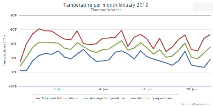
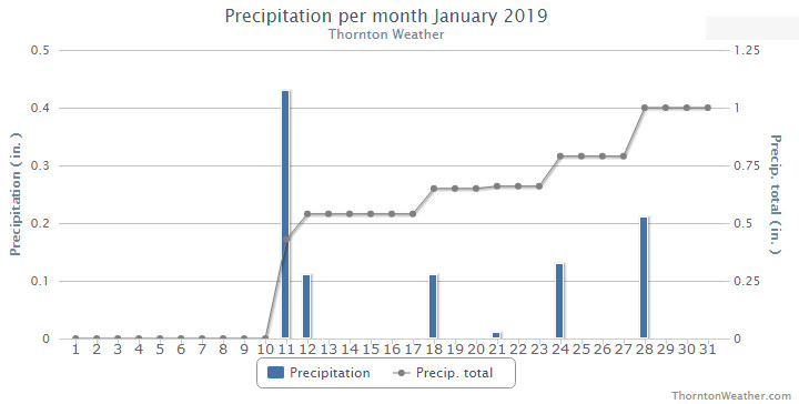
Finally! Our winter thus far had been quite dry so seeing some precipitation in January was a very welcome change. Temperatures were just a bit above normal.
Overall, the month was short on any sort of real weather drama with no major storms or particularly notable temperature extremes. However, a series of storm systems did give us a bit of a roller coaster of weather with five different snow events over the month.
January started out with a very cold New Year’s Day but soon saw warmer temperatures arrive. Our first snow came on the 11th and 12th. This was followed by some smaller events and finally our biggest snowfall of the month on the 28th.
Thornton’s average temperature for the month came in at 31.3 degrees. This was a bit warmer than Denver’s long term overage for January of 30.7 degrees. Out at DIA where Denver’s official readings are taken, it was a bit warmer with an average of 32.0 degrees.
Our mercury readings ranged from a low of 2.2 degrees on the 1st and the 2nd to a high of 61.1 degrees a few days later on the 4th. Denver’s lowest reading was 5 degrees below zero on the first and its warmest of 62 degrees came on the 4th.
In terms of precipitation, Denver averages 0.41 inches of liquid precipitation during January. Thornton easily bested that with an even 1 inch in our bucket. Denver was above average as well with 0.75 inches.
Snowfall in Thornton saw above normal levels with a total for the month of 10.9 inches. Denver, as usual, lagged with 6.2 inches of the white stuff. The 30 year average for Denver for January is 7.0 inches.
Thornton, Colorado’s January 2019 temperature summary. (ThorntonWeather.com)Thornton, Colorado’s January 2019 precipitation summary. (ThorntonWeather.com)
CLIMATE REPORT
NATIONAL WEATHER SERVICE DENVER/BOULDER CO
1026 AM MST FRI FEB 1 2019

...................................

...THE DENVER CO CLIMATE SUMMARY FOR THE MONTH OF JANUARY 2019...

CLIMATE NORMAL PERIOD 1981 TO 2010
CLIMATE RECORD PERIOD 1872 TO 2019

WEATHER         OBSERVED          NORMAL  DEPART  LAST YEAR`S
                 VALUE   DATE(S)  VALUE   FROM    VALUE  DATE(S)
                                          NORMAL
................................................................
TEMPERATURE (F)
RECORD
 HIGH              76   01/27/1888
 LOW              -29   01/09/1875
HIGHEST            62   01/04        76     -14       68  01/09
LOWEST             -5   01/01       -29      24       -4  01/16
AVG. MAXIMUM     44.6              44.0     0.6     49.2
AVG. MINIMUM     19.5              17.4     2.1     20.1
MEAN             32.0              30.7     1.3     34.7
DAYS MAX >= 90      0               0.0     0.0        0
DAYS MAX <= 32      6               5.5     0.5        3
DAYS MIN <= 32     29              29.4    -0.4       28
DAYS MIN <= 0       1               1.7    -0.7        2

PRECIPITATION (INCHES)
RECORD
 MAXIMUM         2.35   1883
 MINIMUM         0.01   1933
                        1934
                        1952
TOTALS           0.75              0.41    0.34     0.54
DAILY AVG.       0.02              0.01    0.01     0.02
DAYS >= .01         6               4.1     1.9        5
DAYS >= .10         2               0.9     1.1        2
DAYS >= .50         0               0.0     0.0        0
DAYS >= 1.00        0               0.0     0.0        0
GREATEST
 24 HR. TOTAL    0.45   01/11 TO 01/11           01/21 TO 01/21

OBSERVED          NORMAL  DEPART  LAST YEAR`S

SNOWFALL (INCHES)
TOTALS            6.2               7.0
RECORD           24.3  1992

DEGREE_DAYS
HEATING TOTAL    1016              1063     -47      932
 SINCE 7/1       3388              3531    -143     3082
COOLING TOTAL       0                 0       0        0
 SINCE 1/1          0                 0       0        0

FREEZE DATES
RECORD
 EARLIEST     09/08/1962
 LATEST       06/08/2007
EARLIEST                        10/07
LATEST                          05/05
.................................................................

WIND (MPH)
AVERAGE WIND SPEED              9.9
RESULTANT WIND SPEED/DIRECTION   4/214
HIGHEST WIND SPEED/DIRECTION    40/290    DATE  01/07
HIGHEST GUST SPEED/DIRECTION    54/350    DATE  01/22

SKY COVER
POSSIBLE SUNSHINE (PERCENT)   MM
AVERAGE SKY COVER           0.50
NUMBER OF DAYS FAIR           10
NUMBER OF DAYS PC             17
NUMBER OF DAYS CLOUDY          4

AVERAGE RH (PERCENT)     58


-  INDICATES NEGATIVE NUMBERS.
R  INDICATES RECORD WAS SET OR TIED.
MM INDICATES DATA IS MISSING.
T  INDICATES TRACE AMOUNT.
Weather, natural disasters & climate news and information.
 We may have changed the calendar to March but it seems like we are receiving weather more common for January. The bone-chilling cold of recent weeks has continued and the Mile High City set two temperature records in as many days.


 February in Colorado typically brings to an end an extended period when average temperatures are at their lowest. Winter begins to loosen its grip and temperatures get warmer but precipitation is not a particularly common event during the month.