Colorado’s famously highly variable weather seems to showcase itself during the month of May when a variety of weather conditions can be seen.
Winter-like temperatures and snow are possible as are mid-summer like temperatures or the more typical spring severe weather.
As the month starts out in 2019 we are going to wear off the chill of recent days and warm up nicely but cooler and wetter weather appear to be on the way. Long range forecasts predict we may be seeing cooler than normal temperatures with above normal precipitation for the month.
The month can certainly bring extremes. Snow is not entirely uncommon during the month, oftentimes causing damage to newly bloomed trees. More common however is severe weather, particularly in the latter half of the month. Thunderstorms become more frequent and their associated hazards – lightning, wind, hail and tornadoes – are usual visitors.
April 7, 2019 – A stunning sunset in Thornton to end the day. (Michelle Jones)
April can be a tricky month weather-wise with everything from mild temperatures to snow to severe weather being possible. The good thing about that is that it provides plenty of chances for great photos!
April marks a transition between winter and summer for most of the country but for Denver it is especially true as we can see a stunning variety of weather.
The proverbial April showers are certainly a possibility for Denver. Snow? Tornadoes? Thunderstorms? You bet – all can happen!
Throw in our usual wildlife plus the wide variety of birds that return to the Centennial State for the spring and summer and there is a lot going on.
Slideshow updated April 29, 2019.
To learn more about how to send your photo to us for inclusion in the slideshow, see below the slideshow.
Showcasing images captured by ThorntonWeather.com readers as well as some of our own, our monthly slideshow covers the entire gamut of weather-related imagery.
Sunsets, sunrises, wildlife and of course every type of weather condition are vividly depicted in images captured from yours and our cameras.
[flickr_set id=”72157708233990884″]
What is missing in the slideshow above? Your photo!
Our monthly photo slideshow is going to feature images that we have taken but more importantly images that you have captured. The photos can be of anything even remotely weather-related.
Landscapes, current conditions, wildlife, pets, kids. Whimsical, newsy, artsy. Taken at the zoo, some other area attraction, a local park, a national park or your backyard. You name it, we want to see and share it!
Images can be taken in Thornton, Denver or anywhere across the extraordinary Centennial State. We’ll even take some from out of state if we can tie it to Colorado somehow.
We’ll keep the criteria very open to interpretation with just about any image eligible to be shown in our slideshows.
What do you win for having your image in our slideshow? We are just a ‘mom and pop’ outfit and make no money from our site so we really don’t have the means to provide prizes. However you will have our undying gratitude and the satisfaction that your images are shared on the most popular website in Thornton.
To share you images with us and get them included in the slideshow just email them to us or share them with ThorntonWeather.com on any of the various social media outlets. Links are provided below.
On June 3, 1981 a tornado struck Thornton in what is the worst twister to have struck the Denver metro area. Are you ready should disaster strike again? Image courtesy the City of Thornton archives.
Severe weather is a fact of life in Colorado – from blizzards to tornadoes we can and do see it all. Each year the weather is responsible for claiming lives in our state and across the nation and the threat is very real. Storm spotter training allows you to learn how to protect yourself and your family while providing a public service.
Education is key to knowing how to protect you and your family. Whether you want to be an official storm spotter or maybe just want to learn more about severe weather, storm spotter training can provide you an incredible opportunity to learn.
The storm spotter program is a nationwide program with more than 280,000 trained spotters. These volunteers report weather hazards to their local National Weather Service office providing vital information when severe strikes. Data from spotters include severe wind, rain, snow measurements, thunderstorms and hail and of course tornadoes.
Storm spotters are part of the ranks of citizens who form the Nation’s first line of defense against severe weather. There can be no finer reward than to know that their efforts have given communities the precious gift of time–seconds and minutes that can help save lives.
By completing one of these training classes you can become an official storm spotter. When severe weather strikes, you can report it by calling a special toll free number or submit your report via the National Weather Service’s website.
These are great sessions for anyone wanting to learn more about the severe weather we experience in Colorado, whether you want to be an official spotter or not. All training is free. Topics include:
Below are the dates, times and locations announced thus far. The embedded calendar should automatically update with new dates and changes but be sure to check the National Weather Service site for the latest.
Thornton, Colorado seasonal snowfall totals as of April 11, 2019. Click for larger image. (ThorntonWeather.com)
Thornton hasn’t had any truly big time snows this year but we have managed a number of respectable ones and that shows in our seasonal snow totals.
As of today, Thornton has received 49.1 inches of snow for the season. That is just slightly below our running 13 year seasonal average of 53.1 inches.
As for Denver, officially, the Mile High City has recorded 43.2 inches thus far this season as measured at DIA. The all-time seasonal average snowfall for Denver is 57.1 inches (55.3 inches 30 year average) so there is still ground to make up there to get near average.
With half of April and all of May to go, there’s still plenty of time to add to those numbers.
In case you were wondering… The average date of Denver’s last snowfall is April 27th. The latest? June 12, 1947 when a trace was recorded. The latest measurable snowfall was 0.4 inches on June 1, 2919.
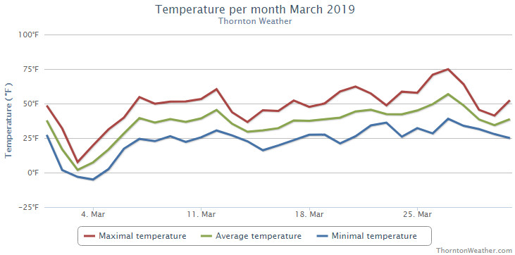
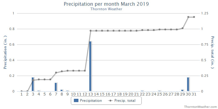
The unstable, cold and wet weather that marked February continued right on into March. Once again, we saw temperatures well below normal and a good bit more than average precipitation.
While the first day of the month started things off relatively nicely, the second brought the first bout of cold. Temperatures plummeted with highs on the third only in the single digits and nighttime low temperatures below zero on the 3rd and 4th. This was coupled with a nice shot of 3.4 inches of snow on the 3rd.
We then slowly warmed up and enjoyed near normal temperatures for a brief period of time. This changed quickly and significantly with the arrival of a blizzard on the 13th. Powerful winds coupled with snow shut down schools, businesses, highways and Denver International Airport.
Calmer, drier weather then took hold for much of the rest of the month although most days continued to see temperatures below normal. The 26th and 27th did offer up our first days of 70 degree or warmer temperatures.
The month closed out with another shot of cold on the 29th and 30th and a light bit of snow.
Thornton’s overall average temperature for the month of March was 35.1 degrees. Out at Denver International Airport here the Mile High City’s official measurements are taken, they matched our temperature with an average of 35.1 degrees as well. Both were well below the historical average March temperature for Denver of 40.4 degrees.
Temperatures in Thornton ranged from a maximum reading of 74.9 degrees on the 27th down to a low of -5.0 degrees on the morning of the 4th. Denver saw its maximum of 73 degrees on the 27th and its minimum of -6 degrees on the 3rd.
Denver set a record low maximum for March 3rd when the temperature only reached a high of 6 degrees. The old record was 14 degrees set in 1978. Additionally, a low temperature reading of -3 degrees on the 4th tied the record low for the date also set in 1960 and 1978.
In terms of precipitation, Thornton recorded 1.19 inches in our bucket while Denver bested us with 1.39 inches. Both were above the long term Denver average for the month of March of 0.92 inches.
Denver’s 0.64 inches of liquid precipitation on the 13th set a daily record, easily besting the old record of 0.43 inches (1926) for the date.
Denver averages 10.7 inches of snow during the month of March. Thornton and Denver beat the average with measurements of 12.2 inches and 12.9 inches respectively.
Thornton, Colorado’s March 2019 temperature summary. (ThorntonWeather.com)Thornton, Colorado’s March 2019 precipitation summary. (ThorntonWeather.com)
CLIMATE REPORT
NATIONAL WEATHER SERVICE DENVER/BOULDER CO
938 AM MDT MON APR 1 2019

...................................

...THE DENVER CO CLIMATE SUMMARY FOR THE MONTH OF MARCH 2019...

CLIMATE NORMAL PERIOD 1981 TO 2010
CLIMATE RECORD PERIOD 1872 TO 2019

WEATHER         OBSERVED          NORMAL  DEPART  LAST YEAR`S
                 VALUE   DATE(S)  VALUE   FROM    VALUE  DATE(S)
                                          NORMAL
................................................................
TEMPERATURE (F)
RECORD
 HIGH              84   03/26/1971
 LOW              -11   03/28/1886
HIGHEST            73   03/27                         73  03/22
LOWEST             -6   03/03                         13  03/07
AVG. MAXIMUM     46.7              54.4    -7.7     58.5
AVG. MINIMUM     23.5              26.4    -2.9     26.8
MEAN             35.1              40.4    -5.3     42.7
DAYS MAX >= 90      0               0.0     0.0        0
DAYS MAX <= 32      3               1.9     1.1        0
DAYS MIN <= 32     28              23.6     4.4       27
DAYS MIN <= 0       3               0.1     2.9        0

PRECIPITATION (INCHES)
RECORD
 MAXIMUM         4.56   1983
 MINIMUM         0.03   2012
TOTALS           1.39              0.92    0.47     1.02
DAILY AVG.       0.04              0.03    0.01     0.03
DAYS >= .01         9               5.9     3.1        6
DAYS >= .10         6               2.4     3.6        3
DAYS >= .50         1               0.3     0.7        0
DAYS >= 1.00        0               0.1    -0.1        0
GREATEST
 24 HR. TOTAL    0.64   03/13 TO 03/13           03/18 TO 03/18

SNOWFALL (INCHES)
RECORDS
 TOTAL           12.9              10.7
RECORD MARCH     35.2    2003

DEGREE_DAYS
HEATING TOTAL     919               763     156      684
 SINCE 7/1       5336              5202     134     4741
COOLING TOTAL       0                 0       0        0
 SINCE 1/1          0                 0       0        0

FREEZE DATES
RECORD
 EARLIEST     09/08/1962
 LATEST       06/08/2007
EARLIEST                        10/07
LATEST                          05/05
.................................................................

WIND (MPH)
AVERAGE WIND SPEED              10.2
RESULTANT WIND SPEED/DIRECTION   1/060
HIGHEST WIND SPEED/DIRECTION    60/340    DATE  03/13
HIGHEST GUST SPEED/DIRECTION    80/340    DATE  03/13

SKY COVER
POSSIBLE SUNSHINE (PERCENT)   MM
AVERAGE SKY COVER           0.60
NUMBER OF DAYS FAIR            4
NUMBER OF DAYS PC             16
NUMBER OF DAYS CLOUDY         11

AVERAGE RH (PERCENT)     67

-  INDICATES NEGATIVE NUMBERS.
R  INDICATES RECORD WAS SET OR TIED.
MM INDICATES DATA IS MISSING.
T  INDICATES TRACE AMOUNT.
April marks a transition between winter and summer for most of the country but for Denver it is especially true as we can see a stunning variety of weather.
The proverbial April showers are certainly a possibility for Denver. Snow? Tornadoes? Thunderstorms? You bet – all can happen!
For good measure throw in a chance for hail and even dust storms and April gives every type of weather condition you could like – or hate.
A bald eagle takes flight over Adams County. (Bill Hutchinson)
The month of March is the start of meteorological spring and while conditions do begin warming, winter weather is certainly out of the question. From hot to cold, snow to rain, the conditions can be very conducive to great pictures as we see in our slideshow.
March in Denver typically means frequent and rapid weather changes. The days grow longer and we start enjoying more sunshine and sometimes summer-like weather. However, on occasion arctic air masses can still force their way south into Colorado dropping temperatures quickly and markedly.
With the active wildlife, increased outdoor activities by us humans, and of course the weather, March imagery contains a wide variety of subjects and extremes.
Slideshow updated March 28, 2019. To learn more about how to send your photo to us for inclusion in the slideshow, see below the slideshow.
Showcasing images captured by ThorntonWeather.com readers as well as some of our own, our monthly slideshow covers the entire gamut of weather-related imagery.
Sunsets, sunrises, wildlife and of course every type of weather condition are vividly depicted in images captured from yours and our cameras.
[flickr_set id=”72157707169706485″]
What is missing in the slideshow above? Your photo!
Our monthly photo slideshow is going to feature images that we have taken but more importantly images that you have captured. The photos can be of anything even remotely weather-related.
Landscapes, current conditions, wildlife, pets, kids. Whimsical, newsy, artsy. Taken at the zoo, some other area attraction, a local park, a national park or your backyard. You name it, we want to see and share it!
Images can be taken in Thornton, Denver or anywhere across the extraordinary Centennial State. We’ll even take some from out of state if we can tie it to Colorado somehow.
We’ll keep the criteria very open to interpretation with just about any image eligible to be shown in our slideshows.
What do you win for having your image in our slideshow? We are just a ‘mom and pop’ outfit and make no money from our site so we really don’t have the means to provide prizes. However you will have our undying gratitude and the satisfaction that your images are shared on the most popular website in Thornton.
To share you images with us and get them included in the slideshow just email them to us or share them with ThorntonWeather.com on any of the various social media outlets. Links are provided below.
RECORD EVENT REPORT
NATIONAL WEATHER SERVICE DENVER/BOULDER CO
305 PM MDT THU MAR 14 2019
…RECORD NON-THUNDERSTORM WIND SPEED AND LOW PRESSURE SET AT DENVER…
THE COLORADO CLIMATE CENTER AND NATIONAL WEATHER SERVICE IN BOULDER HAVE DETERMINED THAT NEW RECORDS HAVE BEEN SET FOR NON-THUNDERSTORM WIND SPEED AND LOW SEA LEVEL PRESSURE AT DENVER INTERNATIONAL AIRPORT DURING THE HISTORIC BLIZZARD OF MARCH 13 2019.
THE HIGHEST WIND SPEED MEASURED DURING THE BLIZZARD WAS 80 MPH AT 1112 AM MDT. THIS IS THE SECOND HIGHEST WIND SPEED EVER RECORDED AT DENVER INTERNATIONAL AIRPORT. THE HIGHEST WIND EVER RECORDED AT DENVER INTERNATIONAL AIRPORT WAS 97 MPH ON JUNE 18 2013, WHEN A TORNADO STRUCK THE MEASURING EQUIPMENT.
THE LOWEST PRESSURE RECORDED ON MARCH 13 WAS 979.01 MILLIBARS AT 843 AM MDT, ADJUSTED TO SEA LEVEL. THE PREVIOUS LOW PRESSURE AT DENVER INTERNATIONAL AIRPORT WAS 979.9 ON FEBRUARY 25 1998. THE RECORD LOW SEA LEVEL PRESSURE AT THE FORMER STAPLETON AIRPORT WAS 976.3 MILLIBARS ON FEBRUARY 9, 1960.
RECORDS BEGAN AT DENVER INTERNATIONAL AIRPORT (KDEN) ON MARCH 1 1995.
Today, March 12, 2019, we saw our warmest temperatures in more than a month. Tomorrow, we are expecting a significant storm that may bring blizzard conditions. That is springtime in Colorado!
The National Weather Service has issued a Blizzard Warning which will be in effect from 10:00am Wednesday until midnight Wednesday. Road conditions are expected to deteriorate and school and business closings seem likely. Power outages are another concern with the wind and heavy snow that is expected.
Throughout the period we will of course be monitoring the system and posting regularly to our Facebook page and Twitter feed. You can follow along in real time below. We are also on Google+ here.
The United States returns to Daylight Saving Time at 2:00am Sunday, March 10, 2019.
The biannual ritual of changing our clocks to adjust for Daylight Saving Time occurs this Saturday night providing yet another signal of the changing of seasons. The United States will ‘spring forward’ one hour at 2:00am Sunday morning as we begin Daylight Savings Time.
The ritual of changing our clocks twice a year can be met with some resistance as some people struggle to adjust their body’s internal clock. The start of Daylight Saving Time can be particularly problematic given the one hour less sleep people receive on the night of the change.
However, longer days as we head into the milder months are a very real benefit and for many worth the inconvenience of a lost hour of sleep. The time change definitely has big effects on how much daylight we enjoy during our normal waking hours.
On Saturday, prior to the change, sunset will occur at 6:00pm but on Sunday the sun won’t disappear over the horizon until 7:01pm. This affords folks more time in the evening to get started on those spring-time chores and allows us to get outside and enjoy the warming weather.
The March Equinox is also on the horizon. Spring officially begins at 3:58pm on Wednesday, March 20.
This year Daylight Savings Time will come to an end on November 3.
Some of the recent history of Daylight Savings Time (from Wikipedia):
Daylight saving time in the United States was first observed in 1918. Most areas of the United States currently observe daylight saving time, with the exceptions being the states of Arizona and Hawaii along with the territories of Puerto Rico, American Samoa, Guam, and the Northern Mariana Islands.
From 1987 to 2006, daylight saving time in the United States began on the first Sunday of April and ended on the last Sunday of October. The time was adjusted at 2:00 AM (0200) local time (as it still is done now).
Since 2007, daylight saving time starts on the second Sunday of March and ends on the first Sunday of November, with all time changes taking place at 2:00 AM (0200) local time.
Daylight Savings Time Schedule
Year
DST Begins 2 a.m.
(Second Sunday in March)
DST Ends 2 a.m.
(First Sunday in November)
2019
10 March 2019
3 November 2019
2020
8 March 2020
1 November 2020
2021
14 March 2021
7 November 2021
2022
13 March 2022
6 November 2022
2023
12 March 2023
5 November 2023
2024
10 March 2024
3 November 2024
2025
9 March 2025
2 November 2025
Weather, natural disasters & climate news and information.


 Today, March 12, 2019, we saw our warmest temperatures in more than a month. Tomorrow, we are expecting a significant storm that may bring blizzard conditions. That is springtime in Colorado!