March 29 to April 4: This week in Denver weather history

This Week in Denver Weather History

This week in Denver weather history is notable for the variety of conditions that can be experienced this time of year.  From hurricane force winds and heavy snow to more typical spring severe weather like tornadoes, all can be experienced this time of year.

From the National Weather Service:

27-29

In 1948…high winds raked Boulder. A wind gust to 75 mph was recorded at Valmont. Sustained winds in excess of 35 mph were estimated in Boulder. Minor damage was reported.

In 1961…heavy snowfall totaled 9.5 inches at Stapleton Airport over the 3 day period. Most of the snow…5.3 inches…fell on the 28th. Winds were generally light and gusted to only 22 mph from the north.

28-29

In 1891…rain changed to snow and totaled 9.7 inches in the city. Northeast winds were sustained to 12 mph with gusts to 28 mph on the 28th.

In 1910…a strong cold front brought much wind…rain…and and snow to the city. Rain on the 28th changed to snow early on the 29th. Snowfall totaled only 2.8 inches…but north winds were sustained to 50 mph on the 29th. Precipitation from the storm totaled 0.96 inch.

In 1994…moist upslope winds combined with an upper level system to dump 5 to 7 inches of snow along the eastern foothills and across metro Denver. Snowfall totaled 6.3 inches at Stapleton International Airport where northeast winds gusted to 39 mph. Thirteen inches of new snow were measured at the Eldora ski area west of Boulder.

28-30

In 1949…a major winter storm dumped 11.3 inches of snow over downtown Denver. Snowfall totaled 10.4 inches at Stapleton Airport. North to northeast winds were sustained to 17 mph.

In 1985…a slow moving snow storm moved across the state. Denver received only 4.0 inches of snowfall with amounts in the foothills totaling 1 to 2 feet. Still…this was enough snow in Denver to cause flight delays of up to 6 hours at Stapleton International Airport on the night of the 29th. East winds gusted to 28 mph on the 28th.

29

In 1887…west winds sustained to 44 mph warmed the temperature to a high of 62 degrees.

In 1921…post-frontal northeast winds were sustained to 46 mph with gusts to 52 mph.

In 1925…southeast winds were sustained to 46 mph with gusts to 48 mph. These were the strongest winds of the month that year. The winds warmed the temperature to a high of 72 degrees.

In 1934…a construction worker was killed by lightning as he walked with a shovel on his shoulder along Cherry Creek in the city. The thunderstorm produced light rain.

In 1967…a southwest wind gust to 52 mph was recorded at Stapleton International Airport. The warm Chinook winds warmed the temperature to 79 degrees equaling the record for the date.

In 1979…a tornado touched down 4 miles southwest of Parker… But caused no reported damage.

In 1998…four children attending a birthday party in Denver were injured when an apparent dry microburst produced a sudden strong wind gust which blew an inflatable playhouse they were occupying into a neighbor’s yard. The playhouse scraped the roof of the host’s two-story house…then landed in the adjoining yard. The children were treated for minor head injuries and cuts.

29-30

In 1938…overnight heavy snowfall was 6.3 inches over downtown Denver.

In 1982…strong winds buffeted metro Denver…breaking windows and damaging roofs. Wind gusts to 90 mph were recorded in Boulder and 51 mph at Stapleton Airport. The strong winds flattened a condominium under construction in Lakewood.

In 1991…1 to 6 inches of snow fell across metro Denver with the heaviest snow confined to the foothills. Six inches of snow was recorded at South Platte in the foothills southwest of Denver and 3 inches at Castle Rock. Snowfall totaled only 0.7 inch at Stapleton International Airport where northeast winds gusted to 33 mph on the 29th.

29-31

In 1970…snowfall totaled 6.0 inches at Stapleton International Airport. Heavy snow accumulation in Boulder on the 29th caused the collapse of a carport at an apartment building…damaging 11 automobiles. Northeast winds gusted to 24 mph at Stapleton International Airport.

30

In 1895…rain changed to sleet…then snow…and totaled 8.0 inches in downtown Denver. Strong post-frontal northeast winds were sustained to 48 mph with gusts to 61 mph. Temperatures hovered around 30 degrees all day.

In 1968…microburst winds associated with virga and brief light rain gusted to 46 mph at Stapleton International Airport.

In 1983…winds gusted to 82 mph at the National Center for Atmospheric Research in Boulder with peak gusts of 70 to 80 mph in the foothills. Minor damage occurred at a construction site and to some homes in Boulder. West winds gusted to 39 mph at Stapleton International Airport.

30-31

In 1896…heavy snowfall totaled 7.5 inches in downtown Denver. Northwest winds gusted to 26 mph.

In 1897…rain changed to snow during the early morning of the 30th and totaled 6.2 inches before ending during the late morning of the 31st. Northwest winds were sustained to 35 mph with gusts to 46 mph.

In 1929…heavy snowfall of 7.0 inches was recorded over downtown Denver. Northwest winds were sustained to 23 mph on the 30th.

In 1953…heavy snowfall totaled 8.6 inches at Stapleton Airport where northeast winds gusted to 23 mph.

In 1955…a vigorous cold front produced north winds at 40 mph with gusts as high as 54 mph at Stapleton Airport. Rain and snow showers and blowing dust accompanied the front. Snowfall totaled only 0.1 inch at Stapleton Airport on the 31st.

In 1988…snow began falling on the afternoon of the 30th and continued through the 31st…burying metro Denver. Twelve to 18 inches of snow fell in the foothills to the west of Denver and Boulder with 6 to 12 inches across the rest of metro Denver. The storm disrupted aircraft operations at Stapleton International Airport where snowfall totaled 7.1 inches and north winds gusting to 32 mph reduced the visibility to less than 1/4 mile at times…causing air traffic delays of 2 to 3 hours.

In 2000…heavy snow once again developed over the foothills and the higher terrain to the south of metro Denver. Snowfall totals from the storm included: 16 inches atop Squaw Mountain…15 inches near Rollinsville…13 inches near Evergreen…12 inches near Morrison…11 inches in Coal Creek Canyon…10 inches near Blackhawk and in Eldorado Springs…9 inches at Ken Caryl Ranch and larkspur… And 8 inches near Elizabeth. Snowfall totaled only 4.1 inches at the site of the former Stapleton International Airport. North winds gusted to 32 mph at Denver International Airport on the 30th.

In 2005…a strong spring storm intensified over the eastern plains of Colorado and produced near-blizzard conditions to the east and southeast of Denver overnight. North to northwest winds from 20 to 35 mph with gusts to 50 mph produced extensive blowing snow and caused near zero visibilities at times and snow drifts from 2 to 4 feet in depth. Snowfall amounts included: 12 inches near Bennett…8 inches around Castle Rock… 7 inches near Sedalia…and 6 inches near Parker. Only 0.3 inch of snow was reported at Denver Stapleton. At Denver International Airport…north winds gusted to 37 mph on the 30th and 36 mph on the 31st.

In 2014…on the evening of the 30th…high based showers and thunderstorms produced microburst winds over northern Jefferson…eastern Boulder and southwest weld counties. Peak wind reports included: 77 mph at white ranch open space; 72 mph…2 miles north of Longmont; 67 mph near Erie and firestone; 60 mph near mead and 59 mph…5 miles northwest of Henderson; with 53 mph at Denver International Airport. The wind downed power lines in Weld County which sparked a small fire. High winds then developed in the Front Range foothills and urban corridor through the morning of the 31st. Peak wind gusts included: 98 mph near gold hill; 77 mph near Eldorado Springs; 61 mph at Centennial Airport; 59 mph at Buckley Air Force Base; with 44 mph at Denver International Airport.

31

In 1873…high winds damaged buildings in the city. Northwest winds with sustained velocities to near 40 mph blew from 9:00 am until sunset.

In 1937…north to northeast winds sustained to 25 mph with gusts to 32 mph produced a light dust storm in the city during the afternoon.

In 1971…wind gusts to 92 mph were recorded in the south hills area of Boulder. At the National Bureau of Standards in Boulder sustained winds of 46 mph with gusts to 83 mph were measured. Damage was minor. Northwest winds gusted to 41 mph at Stapleton International Airport.

In 1983…high winds with gusts to 70 mph in Boulder caused minor damage.

31-1

In 1876…heavy snow began during the night and lasted all day on the 31st and through the morning of the 1st. The average depth of snow fall was 10 to 12 inches…but strong winds whipped the snow into drifts of 8 to 10 feet deep on the streets of the city. Precipitation from the storm was 1.03 inches on the 31st and 0.37 inch on the 1st.

In 1891…heavy moist snowfall totaled 18.0 inches in the city. Northeast winds were sustained to 20 mph with gusts to 24 mph on the 31st.

In 1936…northeast winds sustained to 21 mph produced a light dust storm in the city.

In 1975…a major storm dumped 9.3 inches of snowfall at Stapleton International Airport where northwest winds gusted to 41 mph. Rain changed to snow on the afternoon of the 31st…reducing the visibility to as low as 1/8 mile. Snow continued all day on the 1st and accumulated to a depth of 8 inches on the ground. The minimum temperature of 10 degrees on the 1st set a new record low for the date.

Continue reading March 29 to April 4: This week in Denver weather history

March 22 to March 28: This week in Denver weather history

This Week in Denver Weather History

This week in Denver weather history are a number of interesting events.  As March comes to a close we are not yet done with winter so snow is certainly still possible but we also start seeing more Spring-like weather.  Reminders of this include the coldest temperature ever recorded in March – 11 degrees below zero 123 years ago.  Conversely, 38 years ago the highest temperature ever recorded in March of 84 degrees was recorded.

From the National Weather Service:

20-22

In 1944…heavy snow fell over metro Denver for a total of 36 hours. The storm dumped 18.5 inches of snowfall over downtown Denver and 12.2 inches at Stapleton Airport. Fortunately…there were no strong winds with the storm. North winds to only 19 mph were recorded on the 21st.

21-22

In 1955…wind gusts to 98 mph were recorded at Rocky Flats south of Boulder. Some damage and a few minor injuries were reported in Boulder. Northwest winds were sustained to 28 mph with gusts to 39 mph at Stapleton Airport on the 22nd.

In 1966…a vigorous cold front produced only 1.7 inches of snowfall at Stapleton International Airport…but northeast winds gusted to 49 mph on the 21st. Temperatures cooled from a maximum of 66 degrees on the 21st to a minimum of 14 degrees on the 22nd. Strong winds occurred on both days.

In 1992…an arctic cold front produced upslope snow across metro Denver mainly west of I-25. Castle Rock reported 6 inches of snow with 3 inches at Evergreen. At Stapleton International Airport…only 1.5 inches of snowfall were measured and northeast winds gusted to 18 mph on the 21st.

22

In 1905…apparent post-frontal north winds were sustained to 49 mph.

In 1922…a vigorous cold front with north winds sustained to 41 mph brought only 0.6 inch of snowfall to the city. These were the highest winds of the month.

In 1966…high winds caused extensive blowing snow that impeded traffic and closed highways over a wide area of eastern Colorado. Wind damage was widespread…but minor. North wind gusts to 47 mph were recorded at Stapleton International Airport where visibility was reduced as low as 1/8 mile in blowing snow.

In 1975…a strong west wind gust to 51 mph was recorded at Stapleton International Airport…while east of Denver the strong winds caused minor property damage and considerable blowing dust which closed several roads.

In 1979…near-blizzard conditions paralyzed the northeastern quarter of the state. Strong winds and drifting snow closed many roads…including I-25 and I-70. Power outages darkened sections of metro Denver. Snow accumulations of 4 to 12 inches were measured over the plains with drifts several feet deep. Only 3.5 inches of snow were recorded at Stapleton International Airport where northeast winds gusted to 39 mph causing some blowing snow.

In 1995…strong winds associated with a fast moving pacific cold front moved from the mountains into metro Denver. Winds estimated at 60 to 75 mph picked up rocks and shattered the windows of a car in Louisville. The strong winds blew down and partially destroyed two houses under construction just north of Thornton. West winds gusted to 53 mph at Denver International Airport where the visibility was briefly reduced to 1/2 mile in blowing dust.

In 2016…two brief but powerful gustnadoes developed along a convergence line that formed in the suburbs just north and west of Denver. Three power poles were knocked down. In addition…a small storage shed was destroyed.

22-23

In 1936…heavy snowfall of 7.7 inches was measured in downtown Denver. The heavy wet snowfall formed a thick coating of snow on trees and shrubs…but caused little damage. North winds were sustained to 15 mph.

In 1984…around a half foot of new snow fell across metro Denver…causing flight delays at Stapleton International Airport where snowfall totaled 6.0 inches and north winds gusted to 31 mph. Up to a foot of snow fell in the foothills. Icy roads produced numerous traffic accidents.

In 2011…strong bora winds developed along the Front Range following the passage of a storm system. Peak wind gusts included: 87 mph at the National Wind Technology Center; 82 mph…6 miles northwest of Boulder; 72 mph at Front Range airport in Broomfield; 71 mph at Longmont; and 64 mph…4 miles west of Lakewood. At Denver International Airport…a peak wind gust of 48 mph from the west was observed on the 22nd.

In 2013…a wet early spring snowstorm brought heavy snow to parts of the Front Range foothills and urban corridor. The heaviest snowfall occurred near the Front Range foothills and palmer divide. Near blizzard conditions forced the closure of interstate 70 east of Denver. In the foothills… Storm totals included: 14.5 inches near Conifer; 14 inches just southwest of Eldorado Springs and Intercanyon; 13 inches near Indian Hills; 12.5 inches near Pinecliffe; 11.5 inches near Golden; 11 inches near Jamestown and Roxborough; 10.5 inches near Brookvale and 10 inches at Genesee. Across the urban corridor and Palmer Divide… Storm totals included: 12.5 inches…8 miles southeast of Watkins; 10.5 inches in Boulder…Centennial and Northglenn; 9.5 inches…just south of Aurora; 9 inches in Westminster; 8 inches at Lafayette; 7.5 inches near Morrison; 7 inches in Arvada…Bennett…Brighton; 6 inches in Highlands Ranch… Longmont…Louisville and Thornton. Officially…11.6 inches of snow fell at DIA from the evening of the 22nd to the afternoon of the 23rd…which set a new two-day snowfall record in Denver for the date. In addition…a peak wind gust to 33 mph was observed from the east on the 22nd with a gust to 30 mph from the north on the 23rd.

In 2016…a powerful blizzard developed across the Front Range of Colorado late on the 22nd and continued through much of the 23rd. The storm tracked east-southeast across Utah on the 22nd…and then into southeast Colorado by the morning of the 23rd. The storm rapidly intensified as it reached eastern Colorado…producing extremely heavy and intense snowfall with snowfall rates exceeding 3 inches per hour at times. In addition to heavy snow…strong winds gusting in excess of 50 mph east of I-25 produced widespread blizzard conditions and zero visibilities. The storm initially began with rain on the plains…but quickly changed over to snow during the early morning hours of the 23rd. Snowfall rates of 1 to 2 inches per hour were common…with several inches of snow already accumulating for the morning commute. Many roads became impassable due to the depth of fallen snow…drifting snow…and near zero visibilities during the day. During the peak of the storm… snowfall rates reached or exceeded 3 inches per hour. Widespread road closures occurred…including I-76 from northeast of Denver to the Nebraska state line…I-70 east of Denver to the Kansas state line…and much of I-25… from near Castle Rock to Colorado Springs. The Colorado Department of Transportation estimated over two thousand vehicles became trapped on I-25 near Monument Hill alone… with hundreds of stuck or abandoned cars elsewhere. Numerous power outages occurred as heavy wet snow accumulated on trees…despite the strong winds. At the peak…several hundred thousand residents along the Front Range were without power. Denver International Airport was closed for 7 hours during and just after the peak of the blizzard…with around 1300 cancelled flights. The power outages shut down the fuel farm pumps…the deicing facility…as well as train service to the concourses at the airport. Pea Boulevard…the main road to the airport…was impassable for much of the day. It was the first time since December 21…2006 that Denver International Airport had been shut down due to extreme winter weather conditions. One to 2 feet of snow fell across much of the Front Range Foothills and Urban Corridor. In the foothills of northern Jefferson County…31.5 inches of snowfall measured at Pinecliffe. Most of the snow fell within a 12-hr period from the early morning into the afternoon. A peak wind gust of 59 mph recorded at Denver International Airport. South of Denver…over the Palmer Ridge…12 to 18 inches of snow was reported…with 6 to 10 inches across the adjacent plains. The official snowfall measurement at Denver International Airport was 13.1 inches. In addition…the snow was very heavy and wet…with many areas receiving 1 to 2 inches precipitation. In the foothills…some locations received nearly 3 inches of water from this storm.

22-24

In 1965…a vigorous cold front swept across metro Denver late on the afternoon of the 22nd with east-northeast winds gusting to 38 mph causing some blowing dust. Snowfall from the storm totaled 4.4 inches at Stapleton International Airport. Temperatures on the 22nd dropped from a maximum of 63 degrees to 18 degrees in just 10 hours and dipped to 3 degrees below zero on the morning of the 24th. Maximum temperatures warmed to only 19 degrees on the 23rd and 18 degrees on the 24th.

23

In 1887…west winds sustained to 44 mph warmed the temperature to a high of 66 degrees.

In 1910…southwest winds were sustained to 40 mph. The Chinook winds warmed the temperature to a high of 73 degrees.

In 1913…west winds were sustained to 40 mph with a gust to 44 mph.

In 1951…a Chinook wind gust to 56 mph was recorded at Stapleton International Airport.

In 1957…strong north winds gusting to 62 mph reduced the visibility at times to 1 mile in blowing dust at Stapleton Airport as metro Denver dodged a major spring storm… Which produced heavy rain…snow…wind…and dust over eastern Colorado on the 22nd through the 25th. Snow drifted to 15-foot depths in some areas. All traffic was blocked…power lines were downed…and livestock and crop losses were high.

In 1994…strong winds raked the eastern foothills. While the highest winds occurred north of metro Denver…wind gusts to 74 mph were recorded atop Squaw Mountain near Idaho Springs and to 70 mph at Rocky Flats north of Golden. West wind gusts to 40 mph were recorded at Stapleton International Airport.

In 2005…lightning struck the roof of a home in paradise hills near Genesee. About 5 percent of the residence was damaged by the resulting fire.

Continue reading March 22 to March 28: This week in Denver weather history

National Weather Service announces storm spotter training dates for 2020

On June 3, 1981 a tornado struck Thornton in what is the worst twister to have struck the Denver metro area. Are you ready should disaster strike again? Image courtesy the City of Thornton archives.

Severe weather is a fact of life in Colorado – from blizzards to tornadoes we can and do see it all.  Each year the weather is responsible for claiming lives in our state and across the nation and the threat is very real.  Storm spotter training allows you to learn how to protect yourself and your family while providing a public service.

Education is key to knowing how to protect you and your family.  Whether you want to be an official storm spotter or maybe just want to learn more about severe weather, storm spotter training can provide you an incredible opportunity to learn.

The National Weather Service Denver / Boulder office has announced a series of Skywarn storm spotter training dates for Colorado for the 2020 season.

The storm spotter program is a nationwide program with more than 280,000 trained spotters.  These volunteers report weather hazards to their local National Weather Service office providing vital information when severe strikes.  Data from spotters include severe wind, rain, snow measurements, thunderstorms and hail and of course tornadoes.

Storm spotters are part of the ranks of citizens who form the Nation’s first line of defense against severe weather. There can be no finer reward than to know that their efforts have given communities the precious gift of time–seconds and minutes that can help save lives.

By completing one of these training classes you can become an official storm spotter.  When severe weather strikes, you can report it by calling a special toll free number or submit your report via the National Weather Service’s website.

These are great sessions for anyone wanting to learn more about the severe weather we experience in Colorado, whether you want to be an official spotter or not.  All training is free.  Topics include:

  • Basics of thunderstorm development
  • Fundamentals of storm structure
  • Identifying potential severe weather features
  • Information to report
  • How to report information
  • Basic severe weather safety

To learn more about the program, see here: http://www.crh.noaa.gov/bou/awebphp/spotter.php

Below are the dates, times and locations announced thus far.  The embedded calendar should automatically update with new dates and changes but be sure to check the National Weather Service site for the latest.


–>

‘Springing forward’ as Daylight Saving Time to begin Sunday, March 8th

The United States returns to Daylight Saving Time at 2:00am Sunday, March 8, 2020.

The biannual ritual of changing our clocks to adjust for Daylight Saving Time occurs this Saturday night providing yet another signal of the changing of seasons.  The United States will ‘spring forward’ one hour at 2:00am Sunday morning as we begin Daylight Saving Time.

The ritual of changing our clocks twice a year can be met with some resistance as some people struggle to adjust their body’s internal clock.  The start of Daylight Saving Time can be particularly problematic given the one hour less sleep people receive on the night of the change.

However, longer days as we head into the milder months are a very real benefit and for many worth the inconvenience of a lost hour of sleep.  The time change definitely has big effects on how much daylight we enjoy during our normal waking hours.

On Saturday, prior to the change, sunset will occur at 5:59pm but on Sunday the sun won’t disappear over the horizon until 7:00pm.  This affords folks more time in the evening to get started on those spring-time chores and allows us to get outside and enjoy the warming weather.

The March Equinox is also on the horizon.  Spring officially begins at 9:49pm on Thursday, March 19.

This year Daylight Savings Time will come to an end on November 1.

Some of the recent history of Daylight Savings Time (from Wikipedia):

Daylight saving time in the United States was first observed in 1918. Most areas of the United States currently observe daylight saving time, with the exceptions being the states of Arizona and Hawaii along with the territories of Puerto Rico, American Samoa, Guam, and the Northern Mariana Islands.

From 1987 to 2006, daylight saving time in the United States began on the first Sunday of April and ended on the last Sunday of October. The time was adjusted at 2:00 AM (0200) local time (as it still is done now).

Since 2007, daylight saving time starts on the second Sunday of March and ends on the first Sunday of November, with all time changes taking place at 2:00 AM (0200) local time.

Daylight Savings Time Schedule

Year DST Begins 2 a.m.
(Second Sunday in March)
DST Ends 2 a.m.
(First Sunday in November)
2020 8 March 2020 1 November 2020
2021 14 March 2021 7 November 2021
2022 13 March 2022 6 November 2022
2023 12 March 2023 5 November 2023
2024 10 March 2024 3 November 2024
2025 9 March 2025 2 November 2025
2026 8 March 2026 1 November 2026

February 2020 weather recap: Colder than normal temps, above normal snowfall

Certainly when you look back on February 2020, you probably will remember it as being cold and snowy. That indeed is true, as the numbers show, however that really only pertained to the first half of the month. The latter part was far more on par with what we expect to see.

The month did start out quite warm as we saw temperature readings well above normal on the first and second. The third, however, brought about significant changes and an end to the warmth that had carried over from January.

Several storm systems moved through over the next 10 days, bringing significantly colder temperatures and regular doses of snow. Indeed, 8 of the first 12 days of the month brought measurable snowfall. Into the third week of the month it appeared we were on pace for one of the coldest Februarys on record.

Things changed again on the 21st and five of the last nine days of the month brought warmer than normal temperatures. This was enough to drive up our average temperature which, while it did come in well below normal, was not in record-setting territory.

Thornton’s average temperature for the month came in at 29.9 degrees. This was a good ways below Denver’s long term average for February of 32.5 degrees. Out at Denver International Airport where the Mile High City’s official measurements are taken, it actually was colder with an average of 28.1 degrees.

Our temperatures ranged from a high of 73.7 degrees on the 2nd down to a low of -2.2 degrees on the morning of the 5th. Out at DIA, they saw their warmest and coldest temperatures of 74 degrees and -5 degrees on the same dates.

Precipitation came in well above the Denver average for the month of 0.37 inches. Thornton recorded 1.09 inches while Denver measured 0.88 inches.

Snow was of course notable for the first half of the month and drove the monthly totals. On average, Denver receives 5.7 inches in February.  Thornton far surpassed that with 22.1 inches and Denver did as well with 16.5 inches of the white stuff.

Click here to view Thornton’s February 2020 climate report.

Thornton, Colorado's February 2020 Temperature Summary. (ThorntonWeather.com)
Thornton, Colorado’s February 2020 Temperature Summary. (ThorntonWeather.com)
Thornton, Colorado's February 2020 Precipitation Summary. (ThorntonWeather.com)
Thornton, Colorado’s February 2020 Precipitation Summary. (ThorntonWeather.com)
CLIMATE REPORT
NATIONAL WEATHER SERVICE DENVER/BOULDER CO
717 AM MST SUN MAR 1 2020

...................................

...THE DENVER CO CLIMATE SUMMARY FOR THE MONTH OF FEBRUARY 2020...

CLIMATE NORMAL PERIOD 1981 TO 2010
CLIMATE RECORD PERIOD 1872 TO 2020

WEATHER         OBSERVED          NORMAL  DEPART  LAST YEAR`S
                 VALUE   DATE(S)  VALUE   FROM    VALUE  DATE(S)
                                          NORMAL
................................................................
TEMPERATURE (F)
RECORD
 HIGH              80   02/10/2017
 LOW              -25   02/01/1951
                        02/08/1936
HIGHEST            74   02/02        66       8       65  02/03
LOWEST             -5   02/05                -4      -11  02/07
                        02/04
AVG. MAXIMUM     39.9              46.2    -6.3     40.8
AVG. MINIMUM     16.3              18.9    -2.6     15.3
MEAN             28.1              32.5    -4.4     28.0
DAYS MAX >= 90      0               0.0     0.0        0
DAYS MAX <= 32     10               3.9     6.1        8
DAYS MIN <= 32     28              26.9     1.1       26
DAYS MIN <= 0 2 1.3 0.7 3 PRECIPITATION (INCHES) RECORD MAXIMUM 2.01 1934 MINIMUM 0.01 1970 TOTALS 0.88 0.37 0.51 0.72 DAILY AVG. 0.03 0.01 0.02 0.03 DAYS >= .01         9               5.3     3.7        6
DAYS >= .10         4               0.7     3.3        3
DAYS >= .50         0               0.0     0.0        0
DAYS >= 1.00        0               0.0     0.0        0

GREATEST
 24 HR. TOTAL    0.19     02/12

SNOWFALL (INCHES)
TOTALS           16.5               5.7             13.4  2019
RECORD           22.4      2015

DEGREE_DAYS
HEATING TOTAL    1063               908     155     1029
 SINCE 7/1       4499              4468      31     4417
COOLING TOTAL       0                 0       0        0
 SINCE 1/1          0                 0       0        0

FREEZE DATES
RECORD
 EARLIEST     09/08/1962
 LATEST       06/08/2007
EARLIEST                        10/07
LATEST                          05/05
.................................................................

WIND (MPH)
AVERAGE WIND SPEED              10.3
RESULTANT WIND SPEED/DIRECTION   2/212
HIGHEST WIND SPEED/DIRECTION    40/350    DATE  02/25
HIGHEST GUST SPEED/DIRECTION    54/350    DATE  02/25

SKY COVER
POSSIBLE SUNSHINE (PERCENT)   MM
AVERAGE SKY COVER           0.60
NUMBER OF DAYS FAIR            8
NUMBER OF DAYS PC             13
NUMBER OF DAYS CLOUDY          8

AVERAGE RH (PERCENT)     64

-  INDICATES NEGATIVE NUMBERS.
R  INDICATES RECORD WAS SET OR TIED.
MM INDICATES DATA IS MISSING.
T  INDICATES TRACE AMOUNT.

Thornton’s March 2020 weather preview: Warmer temps arrive, significant snows possible

The month of March in Denver is usually one that is welcomed heartily by residents. We begin to shake off the cold of winter with warmer temperatures and calmer conditions. That does not mean we are done with snow and cold by any means.

March usually offers healthy snowfall giving us an opportunity to add to our seasonal totals.  While there is good snow potential in March, the month also typically brings much warmer temperatures.

March is historically Denver’s snowiest month and brings about 20% of our annual snowfall.  Heavy, wet spring snow storms can oftentimes bring the entire month’s snowfall total in one monstrous snow.

We also start the transition to spring and severe weather season and the month typically brings our first thunderstorms of the year.  Temperatures climb throughout the month and by the end our average daytime highs are near 60 degrees.

For a complete look at what lies ahead in March 2020, click here.

February 2020 top shots: Monthly photo slideshow

An amazing sunset starts off February in style. (Renee Franz)

February signifies the start of the climb toward warmer temperatures for the year.  Cold and snow though do intrude but, coupled with milder conditions, there are lots of photo opportunities as can be seen in our monthly slideshow.

The month is one of our least snowiest of the year but it isn’t unusual to see the landscape blanketed in white.  Warming temperatures through the month can bring the onset of spring fever and gives residents the opportunity to enjoy some prolonged time outdoors on the mild days.

Cold or mild, snowy or dry, our scenery is almost always gorgeous – and photo worthy.

  • Slideshow updated February 28, 2020
  • To learn more about how to send your photo to us for inclusion in the slideshow, see below the slideshow.

Showcasing images captured by ThorntonWeather.com readers as well as some of our own, our monthly slideshow covers the entire gamut of weather-related imagery.

Sunsets, sunrises, wildlife and of course every type of weather condition are vividly depicted in images captured from yours and our cameras.

[flickr_set id=”72157712939478292″]

What is missing in the slideshow above?  Your photo!

Our monthly photo slideshow is going to feature images that we have taken but more importantly images that you have captured.  The photos can be of anything even remotely weather-related.

Landscapes, current conditions, wildlife, pets, kids.  Whimsical, newsy, artsy.  Taken at the zoo, some other area attraction, a local park, a national park or your backyard.  You name it, we want to see and share it!

Images can be taken in Thornton, Denver or anywhere across the extraordinary Centennial State.  We’ll even take some from out of state if we can tie it to Colorado somehow.

We’ll keep the criteria very open to interpretation with just about any image eligible to be shown in our slideshows.

What do you win for having your image in our slideshow?  We are just a ‘mom and pop’ outfit and make no money from our site so we really don’t have the means to provide prizes.  However you will have our undying gratitude and the satisfaction that your images are shared on the most popular website in Thornton.

To share you images with us and get them included in the slideshow just email them to us or share them with ThorntonWeather.com on any of the various social media outlets.  Links are provided below.

So come on, get those camera’s rolling!

Thornton’s February 2020 weather preview: Temps warm and not much snow

4
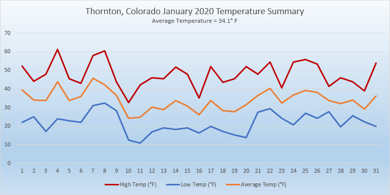
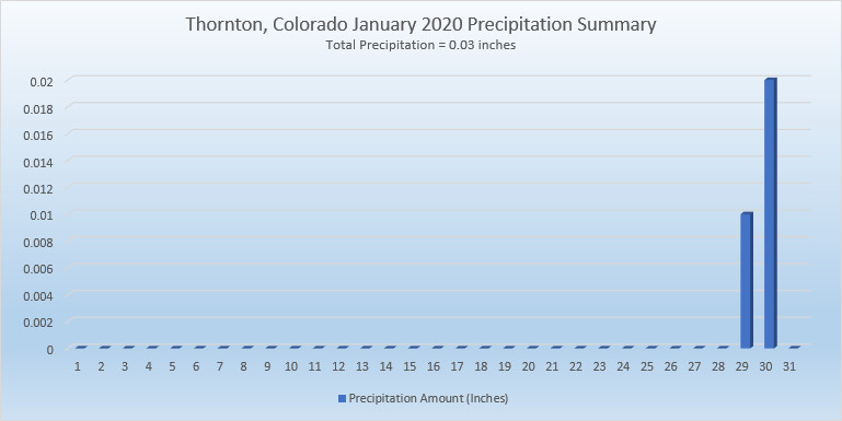
February in Colorado typically brings to an end an extended period when average temperatures are at their lowest. Winter begins to loosen its grip and temperatures get warmer but precipitation is not a particularly common event during the month.
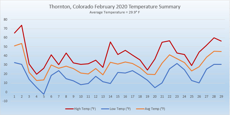
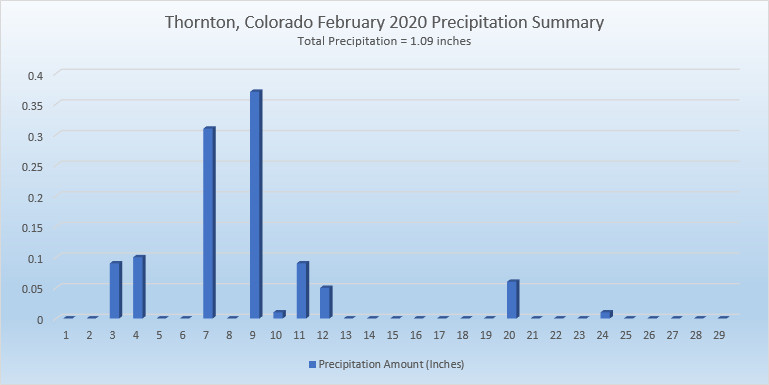
Thus far, our snow season has been a mixed bag. We started fast in October and November but December and January added very little to the totals.  February is only our sixth snowiest month so we may not see much snowfall for the balance of the month.

Temperatures however do usually see a nice rebound during the month. Average high temperatures climb from an average of 44 degrees at the start to 50 degrees by the end of February.

For the complete February preview including a look at historical averages and extremes as well as a look at what long range forecasts are predicting, click here. 

January 2020 weather recap: The year starts off warm and dry

After a cold and snowy start to the season in October and November, December saw things dry out and warm up. Unfortunately, January 2020 continued the most recent trend with temps well above normal and very little precipitation.

The month was largely uneventful with no notable weather events. Daytime high temperatures were routinely warmer than normal and no precipitation was seen until the very end of the month. When we did finally see some snow on the 29th and 30th, it was minimal, amounting to little more than a dusting.

Thornton’s overall average temperature for the month came in at 34.1 degrees. This is well above the long term Denver average for January of 30.7 degrees. As usual, the Mile High City’s official reading at Denver International Airport came in warmer than us at 34.6 degrees.

Temperatures in Thornton ranged from a high of 61.4 degrees on the 4th down to a low of 10.8 degrees on the 11th.  Denver saw its maximum reading of 62 degrees on the 4th and 8th and its lowest of 7 degrees on the 11th.

In terms of precipitation, Denver averages 0.27 inches in January. Both Thornton and Denver fell well short with 0.03 inches and 0.14 inches respectively.

Snow was in short supply with 0.6 inches falling in Thornton and 0.9 inches in Denver. Both were far short of the average of 7 inches for Denver in January.

In the end, the month was Thornton’s warmest, driest and least snowy January since ThorntonWeather.com came online in 2007.

Click here to view Thornton’s January 2020 climate report.

Thornton, Colorado's January 2020 temperature summary. Click for larger view. (ThorntonWeather.com)
Thornton, Colorado’s January 2020 temperature summary. Click for larger view. (ThorntonWeather.com)
Thornton, Colorado's January 2020 precipitation summary. Click for larger view. (ThorntonWeather.com)
Thornton, Colorado’s January 2020 precipitation summary. Click for larger view. (ThorntonWeather.com)

From the National Weather Service:

CLIMATE REPORT
NATIONAL WEATHER SERVICE DENVER/BOULDER CO
717 AM MST SAT FEB 1 2020

...................................

...THE DENVER CO CLIMATE SUMMARY FOR THE MONTH OF JANUARY 2020...

CLIMATE NORMAL PERIOD 1981 TO 2010
CLIMATE RECORD PERIOD 1872 TO 2020

WEATHER         OBSERVED          NORMAL  DEPART  LAST YEAR`S
                 VALUE   DATE(S)  VALUE   FROM    VALUE  DATE(S)
                                          NORMAL
................................................................
TEMPERATURE (F)
RECORD
 HIGH              76   01/27/1888
 LOW              -29   01/09/1875
HIGHEST            62   01/08        76     -14       62  01/04
                        01/04
LOWEST              7   01/11       -29      36       -5  01/01
AVG. MAXIMUM     48.0              44.0     4.0     44.6
AVG. MINIMUM     21.1              17.4     3.7     19.5
MEAN             34.6              30.7     3.9     32.0
DAYS MAX >= 90      0               0.0     0.0        0
DAYS MAX <= 32      1               5.5    -4.5        6
DAYS MIN <= 32     31              29.4     1.6       29
DAYS MIN <= 0 0 1.7 -1.7 1 PRECIPITATION (INCHES) RECORD MAXIMUM 2.35 1883 MINIMUM 0.01 1933 1934 1952 TOTALS 0.14 0.41 -0.27 0.75 DAILY AVG. 0.00 0.01 -0.01 0.02 DAYS >= .01         2               4.1    -2.1        6
DAYS >= .10         1               0.9     0.1        2
DAYS >= .50         0               0.0     0.0        0
DAYS >= 1.00        0               0.0     0.0        0
GREATEST
 24 HR. TOTAL    0.13   01/27

SNOWFALL (INCHES)
TOTALS            0.9               7.0              6.2   2019
RECORD           24.3   1992
TOTAL

DEGREE_DAYS
HEATING TOTAL     937              1063    -126     1016
 SINCE 7/1       3436              3531     -95     3388
COOLING TOTAL       0                 0       0        0
 SINCE 1/1          0                 0       0        0

FREEZE DATES
RECORD
 EARLIEST     09/08/1962
 LATEST       06/08/2007
EARLIEST                        10/07
LATEST                          05/05
.................................................................

WIND (MPH)
AVERAGE WIND SPEED              10.1
RESULTANT WIND SPEED/DIRECTION   4/220
HIGHEST WIND SPEED/DIRECTION    40/290    DATE  01/01
HIGHEST GUST SPEED/DIRECTION    53/290    DATE  01/01

SKY COVER
POSSIBLE SUNSHINE (PERCENT)   MM
AVERAGE SKY COVER           0.50
NUMBER OF DAYS FAIR           10
NUMBER OF DAYS PC             17
NUMBER OF DAYS CLOUDY          4

AVERAGE RH (PERCENT)     49

-  INDICATES NEGATIVE NUMBERS.
R  INDICATES RECORD WAS SET OR TIED.
MM INDICATES DATA IS MISSING.
T  INDICATES TRACE AMOUNT.

January 2020 top shots: Monthly photo slideshow

A beautiful January day in Thornton. (LE Worley)

As one of our coldest months, January can be a good month to hibernate inside and avoid the outdoors.  But, like any month in Colorado, photo opportunities abound as our monthly slideshow demonstrates.

Snow is not normally dominant in the month but when it does fall, it can create a beautiful blanket of white.  Throw in the amazing sunrises and sunsets we receive in the middle of winter as well as wildlife and a host of other subjects and the imagery can be quite beautiful and stunning.

  • Slideshow updated January 27, 2020
  • To learn more about how to send your photo to us for inclusion in the slideshow, see below the slideshow.

Showcasing images captured by ThorntonWeather.com readers as well as some of our own, our monthly slideshow covers the entire gamut of weather-related imagery.

Sunsets, sunrises, wildlife and of course every type of weather condition are vividly depicted in images captured from yours and our cameras.

[flickr_set id=”72157712532896628″]

What is missing in the slideshow above?  Your photo!

Our monthly photo slideshow is going to feature images that we have taken but more importantly images that you have captured.  The photos can be of anything even remotely weather-related.

Landscapes, current conditions, wildlife, pets, kids.  Whimsical, newsy, artsy.  Taken at the zoo, some other area attraction, a local park, a national park or your backyard.  You name it, we want to see and share it!

Images can be taken in Thornton, Denver or anywhere across the extraordinary Centennial State.  We’ll even take some from out of state if we can tie it to Colorado somehow.

We’ll keep the criteria very open to interpretation with just about any image eligible to be shown in our slideshows.

What do you win for having your image in our slideshow?  We are just a ‘mom and pop’ outfit and make no money from our site so we really don’t have the means to provide prizes.  However you will have our undying gratitude and the satisfaction that your images are shared on the most popular website in Thornton.

To share you images with us and get them included in the slideshow just email them to us or share them with ThorntonWeather.com on any of the various social media outlets.  Links are provided below.

So come on, get those camera’s rolling!

Weather, natural disasters & climate news and information.