August 9 to August 15 - This week in Denver weather history
Denver and Colorado as a whole are known for their unusual weather. This week in particular is notable for one extraordinary event in weather history – clouds of grasshoppers!
8-10
In 1979…heavy thunderstorm rains on each of three consecutive days dumped a total of 2.22 inches of rain at Stapleton International Airport. The heaviest rain… 0.95 inches…fell on the 9th. Small hail to 1/8 inch diameter fell on the 8th.
8-13
In 1875…clouds of grasshoppers were seen flying through the air on the prevailing winds during each day.
9
In 1900…a thunderstorm produced west winds sustained to 47 mph with gusts to 55 mph…but only 0.01 inch of rain.
In 1902…a thunderstorm produced no rain and north winds sustained to 52 mph with gusts to 60 mph.
In 1934…heavy cloudbursts in the foothills near Kittredge and at the head of Mount Vernon creek caused flash flooding on both bear creek and Mount Vernon Creek at Morrison… Which resulted in 6 deaths and much property damage. The highway in Mount Vernon Canyon was destroyed by the flood waters.
In 1981…3/4 inch hail fell at Kittredge near Evergreen in Jefferson County.
In 1987…3/4 inch hail fell in Boulder and 9 miles northwest of Castle Rock.
In 1995…lightning struck a 16-year-old counselor in the back of the head while he and a friend were standing under a tree at the singing river ranch…7 miles west of Evergreen. He stopped breathing…but his friend was able to summon help and they were able to revive him. He was hospitalized for a few days and released.
In 1998…brief…weak tornadoes (f0) were sighted near Bennett and Roggen. No damage was reported. Hail as large as 1 inch diameter fell in Franktown with 3/4 inch diameter hail measured near Castle Rock. Thunderstorm winds gusted to 61 mph near Roggen.
August 2 to August 8 - This week in Denver weather history
On first glance our look at this week in Denver weather history appears to be less eventful than many we have looked at previously. However, the severity of the events that appear on the historical weather calendar this week are enough to make you stand up and pay attention. While August is typically a pretty quiet weather month, it is clear that severe weather can certainly strike and Thornton is mentioned in more than one significant event.
From the National Weather Service:
2
In 1878…the high temperature reached 100 degrees in downtown Denver.
In 1911…an apparent dry microburst produced sustained west winds to 42 mph.
In 1972…one workman was killed and another injured when a strong gust of wind destroyed a partially completed apartment building in south Denver. Hail to 1 3/4 inch diameter fell in Golden.
In 1973…hail to 3/4 inch diameter was reported in Boulder.
In 1986…a major outbreak of severe thunderstorms occurred along the Front Range. Thunderstorms developed explosively. Some places were hit by large hail twice. Two inch diameter hail broke car windows on I-25 west of Brighton…and up to 1 1/4 inch hail broke windows in Thornton. Baseball size hail damaged several planes near Watkins. Funnel clouds were sighted around Aurora. Hail over 1/2 inch in diameter covered the ground 3 to 4 inches deep at Hudson northeast of Denver. Most of the hail fell north of metro Denver…but 3/4 inch diameter hail was measured at Stapleton International Airport. Total damage from the hail storms this day was estimated at over 10 million dollars.
In 1991…late afternoon thunderstorms produced heavy rain across metro Denver. Two feet of water covered parts of I-25 in southeast Denver…while one foot of water covered parts of U.S. Highway 285 in Englewood. Thunderstorm rainfall totaled 0.50 inch at Stapleton International Airport.
In 2001…severe thunderstorms producing heavy rain and hail… Either washed out or damaged several County roads in the Watkins and Bennett areas. A small tornado (f0) touched down near Bennett…but did no damage. Hail as large as 1 3/4 inches in diameter fell near Watkins. One inch diameter hail was measured near Hudson and Keenesburg.
In 2008…strong winds blew several trees down in Denver… Damaging homes and downing power lines. A peak wind gust of 67 mph occurred at Centennial Airport…with gusts to 60 mph estimated in Denver. A peak wind gust of 37 mph was measured at Denver International Airport. An elderly man was killed when a wind damaged tree broke free and crushed him while he attempted to remove it. The downed power lines caused outages to about 500 Xcel energy customers.
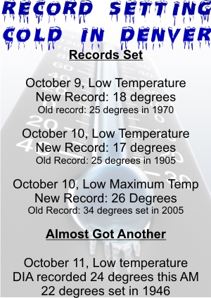
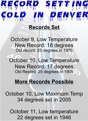
Denver has record setting cool temperatures and snow arrives in the Rocky Mountains. Image courtesy Victor Lewis.
While some parts of the nation experience record setting heat, on Thursday Denver had the opposite problem. The high temperature as measured at Denver International Airport reached a mere 64 degrees. This was two degrees below the previous record low maximum temperature of 66 degrees for this date set in 1925 and previous years. That is also an amazing 24 degrees below the normal temperature for this time of year!
Here in Thornton, we were even cooler than the official temperature on Thursday as the mercury climbed to a mere 61.3 degrees!
The unseasonably cold weather has also brought an unusual sight to the Colorado mountains in July – snow! Some northern parts of the Rocky Mountains in the state above 12,000 feet received a couple inches of snow.
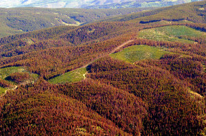
Atmospheric scientists claim the potential for a 50% increase in wildfire activity due to global warming. (AP Photo)
Sounding the warning sirens about the potential repercussions of global warming, Harvard scientists announced their belief that the changing climate will result in a 50% increase in the amount of land burned by wildfires by 2050. Should the predictions come true, the increased smoke from an increase in fires could have the effect of further accelerating warming.
Atmospheric scientists from Harvard’s School of Engineering and Applied Sciences (SEAS) have generated models that show much of the western half of the United States being at much greater risk from wildfires. The study, published in the Journal of Geophysical Research, is said to be the first to measure the impact of future wildfires on air quality.
SEAS Senior Research Fellow Jennifer Logan said, “Warmer temperatures can dry out underbrush, leading to a more serious conflagration once a fire is started by lightning or human activity. Because smoke and other particles from fires adversely affect air quality, an increase in wildfires could have large impacts on human health.”
A man surveys damage to a vehicle struck by a fallen tree after last week's storms. The June 20th hail and wind storm has racked up costs of $350 million in insurance claims. Image courtesy Becki Mullen.
Last week’s hail and wind storm that brought destruction to the west Denver suburbs of Wheat Ridge and Arvada caused $350 million in insured damage according to the Rocky Mountain Insurance Information Association (RMIIA). The end result is a storm that now ranks as the second costliest in state history and adds to an already expensive summer storm season.
The July 20th storm has thus far resulted in 52,400 claims, 19,500 of which were for automobile damage and 32,900 were homeowner claims. RMIIA says that damage would have been much higher had the storm struck during daylight hours when more people and vehicles were on the road instead of in their homes and garages.
Massive trees were uprooted, power poles snapped, windows shattered, and automobiles dented beyond repair when the storm brought winds in excess of 60 mph and golf ball sized hail to the area. Two tornadoes also briefly touched down near Castle Rock and Englewood although they were not responsible for significant damage. 90,000 people lost power during the storm and Xcel Energy deployed more than 200 people into the field to restore electricity.
As summer vacations wind down and families prepare to send their kids back to school in August, Colorado weather also starts to settle down. The chances for severe weather decrease markedly during August and by the end of the month daytime temperatures are dropping quite a bit as well.
At the start of the month Denver usually averages around 88 degrees for a high temperature. By the end of August that drops to 82 degrees. Similarly, nighttime lows drop from 60 to 53 from the start to the end of the month. Generally clear skies can be expected between midnight and noon but the afternoon often brings showers and thunderstorms. These storms typically develop over the foothills then bring precipitation to the Denver metro area.
Despite that moisture, the chance for severe weather decreases considerably compared to the first two months of summer. Cooler air near the surface helps to create a stable atmosphere thus keeping thunderstorms from usually becoming too intense. After the middle of August, tornadoes and damaging hail are pretty rare. The slow movement of storms this time of year are more likely to produce potentially heavy rain.
A new study says he El Niño-Southern Oscillation (ENSO) accounts for the vast majority of temperature variability.
A new peer-reviewed study calls into question the so-called ‘consensus’ on the causes of global warming by saying that “Nature, not man, responsible for recent global warming.” The new study authored by three Australian scientists and published in the Journal of Geophysical Research says that the El Niño-Southern Oscillation (ENSO) accounts for the vast majority of temperature variability.
Authored by Chris de Freitas (University of Auckland in New Zealand), John McLean (Melbourne) and Bob Carter (James Cook University), the new study is sure to cause waves among those debating the causes of global warming. Completely contrary to the mainstream media’s portrayal of climate change, the study says, “little or none of the late 20th century global warming and cooling can be attributed to human activity.”
Lead author de Freitas said in a press release, “The surge in global temperatures since 1977 can be attributed to a 1976 climate shift in the Pacific Ocean that made warming El Niño conditions more likely than they were over the previous 30 years and cooling La Niña conditions less likely.”
July 26 to August 1 - This week in Denver weather history
Weather can be deadly – we are all well (hopefully) aware of that. Looking at this week in Denver weather history we are reminded of that and the tragedy that weather can bring to our state. We see numerous cases of lightning causing death and injury but no one incident highlights the dangers of weather more than what occurred on July 31, 1976. The Big Thompson Flood was Colorado’s worth weather-related disaster and claimed 144 lives. More details on all these events are below.
13-5
In 2008…a streak of 26 consecutive days of 90 degrees shattered the previous record of 18 consecutive days established in 1901 and 1874. Ironically…no new single day record high temperatures were set in the month of July. In August however…a record of 104 degrees was set on the 1st…and another record of 103 degrees was set on the 2nd. In addition…a record low min of 70 degrees was set on August 2nd.
26
In 1891…a thunderstorm produced sustained northeast winds to 44 mph with gusts to 60 mph and 0.16 inch of rain.
In 1894…a thunderstorm produced sustained southwest winds to 36 mph with gusts to 58 mph…but only 0.04 inch of rain.
In 1910…the high temperature reached 100 degrees in downtown Denver.
In 1959…a Denver man was stunned while standing by a car that was struck by lightning. He was treated for burns and shock at a local hospital. Thunderstorm winds gusted to 55 mph at Stapleton Airport.
In 1983…two heavy thunderstorms hit the northern and western suburbs. The first drenched Northglenn with an inch of rain in 30 minutes. The second storm dumped an inch or more of rain in Idaho Springs and Evergreen. The heaviest rainfall… 2.90 inches in an hour…caused minor street flooding in Golden.
In 1984…heavy early morning thunderstorms drenched the foothills southwest of Denver. Rainfall to 1 1/2 inches in just 30 minutes occurred between Evergreen and Conifer. In nearby turkey creek canyon…1.80 inches of rain was recorded in 35 minutes.
In 1985…a long rope-like white tornado touched down 5 miles east of Erie and stayed on the ground…mainly over an open field…for 18 minutes. However…the twister damaged a few cars on I-25 and injured 3 people from broken glass. The storm flipped over a van…blew out car windows…and ripped a highway sign. It also blew an outbuilding off its foundation. A tornado also touched down briefly 8 miles north of Bennett. No damage was reported from this storm.
In 1988…a 9-year-old girl was slightly injured by lightning in Parker.
In 2003…a severe thunderstorm in and south of Franktown produced hail as large as 1.75 inches in diameter.
July 19 to July 25 - This week in Denver weather history
This week in weather history we really begin to see the arrival of monsoon season and the heavy rains and flooding it can bring to the Thornton and Denver area. Be sure to check out the events on the 23rd and what the heavy rain brought to the Thornton area in 2004.
13-5
In 2008…a streak of 26 consecutive days of 90 degrees shattered the previous record of 18 consecutive days established in 1901 and 1874. Ironically…no new single day record high temperatures were set in the month of July. In august however…a record of 104 degrees was set on the 1st…and another record of 103 degrees was set on the 2nd. In addition…a record low min of 70 degrees was set on august 2nd.
18-19
In 2003…heavy rain producing thunderstorms caused flash flooding across southern metro Denver. Automated rain gages measured 2 to 3 inches of rain in less than an hour. The heavy rainfall caused many intersections and underpasses to flood…stranding motorists. Sections of I-25 and I-225 were closed due to the high water.
19
In 1875…recent heavy rains produced high waters on many creeks and rivers in the area…which threatened the destruction of property at some locations. Cherry Creek in the city was running the highest in 10 years. Heavy rain in the mining regions over the last 2 days resulted in water running “everywhere” and the suspension of some work.
In 1881…a thunderstorm passing across the city produced lightning with no rain. A woman was seriously injured when struck by lightning several blocks from the weather office in downtown Denver.
In 1934…the temperature reached a high of 100 degrees in downtown Denver.
In 1965…hail…rain…and lightning hit west metro Denver. Hail stones as large as 1 1/2 inches in diameter accumulated to a depth of 2 inches in Evergreen where 2.95 inches of rain in 2 hours caused some flooding in the business section of the town. Lightning caused some power outages.
In 1973…two funnel clouds were observed 5 miles southeast of Littleton. The same funnel clouds were observed for 20 minutes…5 miles west and 5 miles west-southwest of Arapahoe County airport…now Centennial Airport.
In 1975…lightning injured a man in Denver and caused power outages in Aurora…Lakewood…Westminster…and west Denver.
In 1984…strong thunderstorm winds gusting to 45 mph shattered 7 large plate glass windows at Stapleton International Airport.
In 1985…a tornado touched down in the surrey ridge area of northern Douglas County…just west of I-25. Ten homes were damaged; one under construction was nearly destroyed. Two vehicles were thrown off I-25 injuring three people. A pick-up truck was thrown 50 feet by the twister. In addition…a cluster of severe thunderstorms pounded all of metro Denver with torrential rain…hail…and wind. The heaviest rain fell in Aurora where one location reported 2.37 inches in just 40 minutes. One location in northeast Aurora received a total of 4.30 inches from the storm. There was extensive street and basement flooding…and a number of roads were damaged or washed out. An Aurora boy suffered minor injuries when he was washed into a drainage ditch. Golf ball size hail in Aurora piled up to 5 inches deep. An inch of rain fell in 20 minutes at Stapleton International Airport…closing it to air traffic for an hour. Up to 1 1/2 inches of rain fell in just 15 minutes over central Denver with the high water closing I-25. The water was so deep on the freeway…that one vehicle was completely submerged and people were diving into the water from the freeway overpass. Three homes in Littleton were damaged by lightning. Wind blew out several windows from a high rise apartment building in southeast Denver. Rainfall totaled 1.51 inches at Stapleton International Airport.
In 1997…torrential rain and damaging hail pummeled eastern sections of metro Denver. Hail up to 1.25 inches in diameter fell at the national weather service office on the site of the former Stapleton International Airport. The hail continued for about 15 minutes and accumulated to a depth of 2 to 3 inches…causing extensive damage to cars in the area. Heavy rainfall totaled 3.83 inches in about an hour from the nearly stationary thunderstorm. Numerous cars stalled along I-70…and several homes were flooded in east Denver. The roof of a building collapsed under the weight of the water. The next day several “fatalities” were discovered near the national weather service office; two prairie dogs were found dead along with three rabbits that either drowned or were killed by the large hail.
In 1999…lightning struck two residences in Littleton…but caused only minor damage. Lightning triggered a fire at a residence in cherry hills village. A small portion of the roof and ceiling were damaged before the fire could be extinguished.
In 2000…hail as large as 1.25 inches in diameter fell near Roggen northeast of Denver.
In 2004…heavy rainfall caused flooding on the Virginia Canyon Road near Idaho Springs…which had to be closed for repairs.
In 2006…the temperature climbed to a high of 100 degrees. The high temperature was not a record maximum for the date.
In 2007…a severe thunderstorm produced large hail…up to 1 inch in diameter…about 6 miles north of Northglenn.
July 12 to July 18 - This week in Denver weather history
A busy week in Denver weather history for sure. Most notable are the occurences of flooding that seem to happen with regularity as well as the costliest hail storm in American history.
11-12
In 1872…heavy rain from 4:00 pm until 2:00 am caused much damage. Rainfall totaled 1.76 inches.
12
In 1881…during the early evening…a brisk rain fell for 30 minutes from a nearly clear sky containing not one tenth of clouds with the sun shining brightly. Rainfall was 0.16 inch.
In 1885…thunderstorms produced widespread lightning across the city during the evening. Several people were injured when their homes were struck by lightning.
In 1954…the high temperature reached 101 degrees at Stapleton Airport.
In 1962…lightning struck and killed a Denver man…while he was assisting a co-worker with his car.
In 1971…the temperature climbed to a high of 101 degrees at Stapleton International Airport.
In 1974…hail to 3/4 inch in diameter fell in Castle Rock.
In 1991…hail to 2 inches in diameter fell in Thornton with golf ball size hail in Brighton. Dime size hail was recorded in the city of Denver. Very heavy rain caused flooding across metro Denver. Water was up to 2 feet deep in parts of Golden where one foot of water was reported in the lot of a mobile home park. Flood water washed away part of a parking lot at the Colorado school of mines in Golden. Heavy rain caused a rock slide and flooding along I-70 in the foothills just west of Denver. Flood waters were a foot deep at the intersection of I-70 and I-25 just north of downtown Denver. A funnel cloud was sighted just east of the rocky mountain arsenal.
In 1996…very heavy rainfall from a fast moving thunderstorm dumped 2 to 3 inches of rain within an hour over southern Jefferson County. Two people were killed near the town of buffalo creek when a 20-foot wall of water flooded the area. Utility poles and trees were uprooted; cars… Propane tanks…and bridges were destroyed in the flood’s path. Entire buildings were moved from their foundations and heavily damaged by the floodwaters. The first fatality occurred along State Highway 126 when the driver of a pick-up truck was washed off the road by the deadly wall of water. The second death occurred farther upstream when a man in a 5th-wheel trailer was washed away. This was the second disaster to strike the area in the last couple of months. The community was already recovering from a wildfire which burned about 12 thousand acres of forest land in late May. With the forest burned by fire…very little vegetation was available to slow the storm’s runoff…which resulted in the flash flood. Power…water…and sewer service were heavily damaged in the flood and…in some cases…beyond repair. The cost of repairing the roads and water system in the area was estimated at around a half million dollars. Elsewhere across metro Denver…severe thunderstorms produced hail…damaging winds…and small tornadoes. Weak tornadoes (f0) were reported in Broomfield… 3 miles east of Englewood…and in Dacono. No damage was reported…except a trampoline was blown into a window and several trees were downed in Broomfield. Thunderstorm wind gusts estimated as high as 60 mph blew a fence down in Louisville where winds also toppled a tree near a house. The house received only minor damage. Large hail…strong winds and heavy rain caused substantial property damage in portions of southeastern Boulder and northern Jefferson counties. Damage estimates in the Broomfield area alone were about 1 million dollars. Winds gusted to 81 mph in Broomfield. Large hail…3/4 to 1 1/2 inches in diameter fell in Evergreen…Lakewood…Englewood…Broomfield…near Morrison…northeast of Boulder…and just east of Denver International Airport.
In 2000…heavy rain fell across a portion of the hi meadow fire burn area near buffalo creek…causing localized flooding. About 3/4 inch of rain fell in 30 minutes over miller gulch. Some culverts become plugged by debris from the fire. As a result…small sections of a u.s. forest service road along miller creek were washed out. Lightning struck a home in Castle Rock…causing extensive damage to the roof…attic…and second floor.