April 18 to April 24 – This week in Denver weather history

April 18 to April 24 – This week in Denver weather history

April can truly bring just about any kind of weather to the Denver area.  From blizzards and snowstorms that are more common in the deepest part of winter to severe spring-like weather like tornadoes and hail, we can and do see it all.  Our look back at this week in Denver weather history shows all of those conditions and more.

17-18

In 1878…the wind blew violently all day on the 17th with a maximum sustained velocity of 40 mph.  Dust hung over the city like a cloud.  The relative humidity was zero nearly all day.  A terrific gale blew overnight.  There was much damage to buildings…signs…fences…etc.  Some wind gusts were so strong as to jar buildings to their foundations.  The station anemometer recorded sustained winds to 50 mph with higher gusts before it was damaged by the winds.  The winds moderated during the day on the 18th and ended at sunset.
 
In 1894…post-frontal rain changed to snow on the 17th around sunrise and continued through 9:00 am on the 18th. Snowfall totaled 10.5 inches…but most of the snow melted as it fell.  The high temperature warmed to only 35 degrees on the 17th after a high of 76 on the 16th.  Northeast winds were sustained to 30 mph with gusts to 32 mph on the 17th.
 
In 1998…more spring snow fell across metro Denver and in the foothills.  Snowfall totals included:  11 inches at Golden Gate Canyon; 10 inches at Highlands Ranch; 9 inches at Elizabeth; 8 inches at Broomfield and Morrison; and 7 inches at Chief Hosa…Evergreen…Littleton…and Sedalia. Snowfall totaled only 3.2 inches at the site of the former Stapleton International Airport.  North winds gusted to 22 mph at Denver International Airport.

17-19

In 1920…snow fell across the city continuously for 57 hours… From the early morning of the 17th until 11:40 am on the 19th.  The heavy wet snowfall totaled 18.2 inches with the greatest accumulation on the ground of 12 inches.  Winds during the storm were strong with sustained speeds in excess of 27 mph for over 40 consecutive hours…which created near-blizzard conditions.  The highest recorded wind speeds were 44 mph with gusts to 50 mph from the north on the 17th and 39 mph with gusts to 48 mph from the northwest on the 18th.  The strong winds piled the snow into high drifts which stopped all Denver traffic. Railroads were blocked with only one train entering the city on the 19th.  All interurban trains were blocked…as were the 13 trolley lines.  Thus…many workers were unable to get home at night and filled all of the downtown hotels to capacity.  No grocery or fuel deliveries were possible… Except milk and coal to hospitals and to families with babies.  No lives were lost in the city…but several people perished in surrounding districts.  Stock losses were heavy on the plains.  Temperatures during the storm were in the 20’s.

18

In 1877…strong winds blew all day with an average sustained velocity of 36 mph.  The maximum sustained velocity was 60 mph.  No significant damage was reported.
 
In 1903…northwest winds were sustained to 48 mph with gusts to 53 mph.
 
In 1936…light dust spread over the city from the east on southeast winds gusting to 25 mph.  The surface visibility was reduced to about 2 miles at times.
 
In 1940…this date marked the start of the longest period without snow…200 days…through November 3…1940.  A trace of snow fell on both April 17…1940…and November 4…1940.
 
In 1963…strong winds were prevalent all day across metro Denver.  West-northwest winds gusting to 60 mph produced some blowing dust at Stapleton Airport.
 
In 1971…a microburst wind gust to 59 mph produced some blowing dust at Stapleton International Airport.
 
In 1978…high winds caused much blowing dust over the plains. Wind gusts from 80 to 96 mph were reported in Boulder with 80 mph measured on Lookout Mountain.  Northwest winds gusted to 43 mph at Stapleton International Airport.
 
In 2000…high winds developed in the foothills of Boulder County.  Peak wind gusts included 71 mph at the National Center for Atmospheric Research Mesa Lab near Boulder. In Aurora…three workers were injured when strong winds caused a home under construction to partially collapse. Two received minor injuries…while the third worker had to be hospitalized with severe back injuries.  South winds gusted to 47 mph at Denver International Airport.
 
In 2002…strong northeast winds behind a cold front gusted to 53 mph at Denver International Airport where some blowing dust briefly reduced the visibility to 3 miles.

Continue reading April 18 to April 24 – This week in Denver weather history

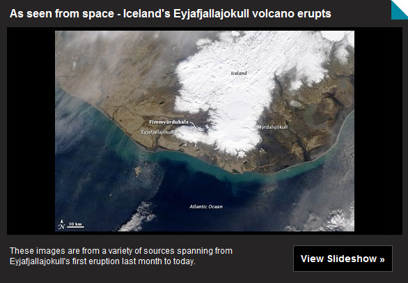
Satellite imagery of Iceland volcano eruption

Satellite image of the Eyjafjallajokull volcano in Iceland erupting
NASA's Terra satellite flew over the volcano on April 16 10:45 UTC (6:45 a.m. EDT) and the MODIS instrument captured a visible image of Eyjafjallajökull's ash plume (brown cloud) stretching from the U.K. (left) to Germany (right). (NASA/MODIS Rapid Response Team) Click on the image or on the link below to view a slideshow of satellite photos of the eruption.

Satellites by space agencies across the globe have trained their ‘eyes in the sky’ on Iceland and the erupting Eyjafjallajokull volcano. From their perch hundreds of miles above the Earth’s surface, these satellites can capture images of the volcano and its ash plume as it travels across northern and central Europe.

The ash cloud has now traveled hundreds of miles over northern Europe where it has created the biggest travel disruptions since the September 11th terrorist attacks. Thousands of flights have been cancelled and hundreds of thousands of passengers have been stranded across the world.

At Denver International Airport, United Airlines and British Airways cancelled their non-stop service to and from London’s Heathrow airport Saturday. This marks the third day in a row for the disruption.

The volcanoes activity increased overnight and continues on Saturday. Eurocontrol, the European agency responsible for air travel over the continent, reports that 16,000 flights had been cancelled on Saturday. On a normal Saturday the organization would monitor 22,000 flights.

Satellite images in the slideshow below from NASA, the European Space Agency (ESA) and others provide an incredible look into the event.    

Image of Iceland's Eyjafjallajokull volcano

Iceland’s Eyjafjallajokull volcano disrupts travel across the globe

Taken Wednesday, April 14, 2010, this image from the Icelandic Coastguard shows smoke and steam rising from the volcano under the Eyjafjallajokull glacier in Iceland, which erupted for the second time in less than a month, melting ice, shooting smoke and steam into the air and forcing hundreds of people to flee rising floodwaters. (Icelandic Coastguard)

With no signs of the Eyjafjallajokull volcano in Iceland stopping its latest eruption, international flights to and from Europe at Denver International Airport were cancelled for the second day in a row in Friday. The ash plume from the volcano has cancelled thousands of flights worldwide and stranded tens of thousands of passengers.

Travelers through Denver expect the weather to cause problems but rarely would they think a volcano more than 3,500 miles away would cancel their travel plans.

Both United Airlines and British Airways canceled their non-stop service to and from London Thursday and Friday and it now appears Saturday’s flights will be cancelled as well.  London’s Heathrow Airport is reporting that it will remain closed until at least 1:00am (local time) on Sunday.

As the ash cloud has spread, so too have its effects. The European air traffic control agency, Eurocontrol, said that flights have also been grounded in France, Denmark, Norway, Sweden, Finland and Belgium.

Volcanic ash presents a very real danger not only those close to an eruption but also to airplanes flying anywhere in the vicinity. The ash from volcanoes can travel hundreds of miles and when ingested by jet aircraft engines, can result in a total loss of power.

KLM Flight 867, a 747 bound for Anchorage, Alaska in December 1989 inadvertently flew into ash that had been discharged by Mount Redoubt. All four engines lost power for give minutes and the aircraft fell from 27,900 feet to 13,300 feet before it was able to restart its engines.

In 1982 a British Airways 747 flew through the ash cloud of an erupting Mount Galunggung in Indonesia. All four engines on the aircraft lost power but were able to be restarted after the aircraft exited the cloud.

More information on the Eyjafjallajokull volcano eruption from the Natural Disasters Examiner:

Statewide tornado drill to occur in Colorado on Wednesday

This funnel cloud was seen from the Thornton Civic Center (looking north) on June 10, 2009. Image courtesy Lisa Wilson, the City of Thornton.

If you happen to be outside or listening to broadcast media this morning, don’t be surprised to hear a tornado warning / siren. As part of Severe Weather Awareness Week, the National Weather Service will be conducting a statewide tornado test around 9:15am.

The service is urging all government agencies, schools, businesses, broadcast media and emergency management agencies to participate in this important drill.

This is a good time for citizens to ensure they are prepared and know what to do when a tornado strikes. As we saw with last year’s tornado activity and in 2008 with the Windsor tornado, twisters can and do strike the Denver area. Preparation and planning are critical to ensuring you and your family remain safe.

It is perhaps most fitting that Colorado saw its first tornado of 2010 yesterday. The twister which struck in Kit Carson County 11 miles south-southwest of Bethune caused no damage. However, it serves as an important reminder.

Will you hear tornado sirens in Thornton?  Unfortunately not.  The city does not have a warning system in place.  Find out why.

Do you know what to do when a tornado strikes?  Learn what you can do to protect you and your family here.

Thornton Community Chorus set to hold auditions

Thornton Community ChorusHaving completed its organization and now with a board in place, the Thornton Community Chorus (TCC) is set to hold auditions this coming Saturday, April 17, 2010. 

Supported by the Thornton Arts, Sciences and Humanities Council (TASHCO), the Thornton Community Chorus adds to the cultural offerings for Thornton residents. 

Next for the group are auditions for performers that will be held this coming Saturday at ITT Technical Institude (500 E 84th Ave) from 9:00am to 12:00pm.  Singers and other musicians are encouraged to try out and help bring this new musical experience to the City of Thornton and the north metro area. 

Mary Lindow, President of TCC, said that they are anxious to get going and expect to hold their first performance in the coming months. 

For all the details on the chorus, a complete event calendar and more information about the auditions, please visit their website at: http://www.thorntoncommunitychorus.org

April 11 to April 17 – This week in Denver weather history

April 11 to April 17 - This week in Denver weather history

We are far from finished with winter weather as is clearly shown in our look back at this week in Denver weather history.  There are many occurrences of snowstorms wreaking havoc in the Mile High City.  One such notable event was just five years ago when 1 to 2.5 feet of snow was dumped on the Front Range.

7-12

In 1959…snow falling over a 5-day period totaled 20 to 30 inches just east of the mountains…while over the plains blizzard conditions closed schools and blocked highways. The second big storm in two weeks dumped 16.4 inches of snowfall on Stapleton Airport with the most…11.6 inches… Occurring on the 8th.  East winds gusted to 37 mph on the 9th.  Temperatures dipped into the single digits on the mornings of the 7th and 12th when 7 degrees were registered.  Low temperature records for the dates were set on the 9th…10th…and 12th.  The cold temperatures caused streets to glaze with ice…resulting in the death of a pedestrian who was struck by a car in Denver.  Three people died from heart attacks while shoveling the heavy… Wet snow.

9-11

In 1951…heavy snowfall totaled 9.4 inches at Stapleton Airport.  The storm was accompanied by strong northeast winds gusting to 43 mph.
 
In 1953…heavy snowfall occurred at Stapleton Airport where 7.9 inches of snow were measured.  North winds gusted to 29 mph.
 
In 1994…6 to 14 inches of heavy snow buried much of eastern Colorado…closing many schools and I-70 from east of Denver to the Kansas border.  Rain changed to snow on the 9th…and snow continued through the 11th.  Snowfall totaled 5.7 inches at Stapleton International Airport…but maximum snow depth on the ground was only 3 inches on the 10th due to melting.  East winds gusted to 26 mph on the 9th.
 
In 1995…a major spring storm dumped 8 to 16 inches of snow in the foothills west of Denver.  Snowfall totaled 8.3 inches at the site of the former Stapleton International Airport…but most of the snow melted as it fell with the maximum snow depth on the ground of only 2 inches.  Five-to 6-inch snow accumulations occurred over southern portions of metro Denver and eastward onto the plains.  Northeast winds gusted to 36 mph at Denver International Airport on the 10th.  I-70 was closed for several hours east of Watkins to the Kansas border due to drifting snow and near whiteout conditions.  High temperature of only 29 degrees on the 10th was a record low maximum for the date.

9-12

In 1901…rain changed to snow and totaled 10.8 inches in downtown Denver over the 4 days.  Northeast winds were sustained to 28 mph with gusts to 31 mph on the 11th. Temperatures hovered in the 30’s.

10-11

In 1979…a heavy snow storm produced near-blizzard conditions across eastern Colorado with 10 to 20 inches in the foothills and 4 to 8 inches over the plains.  Winds to 35 mph combined with the snow to produce drifts at least 3 feet deep…closing many roads and causing power outages. Travel was interrupted south of Denver when the storm closed both I-25 and State Highway 83.  Snowfall totaled only 3.8 inches at Stapleton International Airport where northeast winds gusted 37 mph…causing some blowing snow on the 11th.
 
In 2001…a potent spring storm dumped heavy snow over metro Denver and the adjacent foothills…while a blizzard roared across the plains to the east of Denver.  Snowfall amounts ranged up to a foot and a half across metro Denver and in the foothills.  North to northwest winds at sustained speeds of 40 to 50 mph with gusts as high as 60 mph piled the snow into drifts of 3 to 6 feet deep.  I-25 southbound was closed at lincoln avenue.  I-70 to the east was closed at gun club road.  The combination of heavy wet snow and damaging winds resulted in widespread electrical outages. Denver International Airport was completely shut down for the first time in its brief 6-year history.  Power surges and outages crippled the airport’s massive computer systems. The airport was closed at 5:00 am and did not re-open until mid-afternoon on the 11th.  The power outages resulted in businesses and schools closing.  Over all of northeastern Colorado…there were 220 thousand customers without power… The worst outage in Xcel energy’s history.  Repairs totaled 1.6 million dollars.  Across metro Denver…snow totals included:  18 inches in southeast Aurora…16 inches at centennial airport and Parker…14 inches at Broomfield… 13 inches in Louisville…12 inches at Lakewood and Morrison… 11 inches at Ken Caryl and Thornton…10 inches at the site of the former Stapleton International Airport and in Wheat Ridge…9 inches in Westminster…and 8 inches in Littleton. Thunderstorms preceded the start of the snow on the afternoon of the 10th and were embedded in the snow storm during the early morning hours of the 11th at Denver International Airport where northwest winds gusted to 60 mph on the 11th.  Snow storm totals in the foothills included:  17 inches at Genesee…16 inches at Rollinsville… 14 inches at Intercanyon…13 inches in Coal Creek Canyon and near Evergreen…11 inches at Aspen Springs and Chief Hosa…10 inches at Blackhawk…and 9 inches atop Crow Hill.
 
In 2005…a strong spring storm produced blizzard conditions in areas to the east of Denver and south of I-76 and near- blizzard conditions across metro Denver.  The combination of heavy snow and strong winds forced the closure of Denver International Airport…stranding thousands of travelers. Long stretches of I-25…I-70…and I-76 were also closed due to extensive blowing and drifting snow.  Snow amounts ranged from 1 to 2.5 feet in and near the eastern foothills and over the Palmer Divide.  Drifts were 2 to 5 feet in depth.  Downed power lines caused scattered electrical outages.  Storm total snowfall amounts in and near the foothills included:  31 inches near Conifer; 27.5 inches in Aspen Springs; 25.5 inches near Sedalia and Blackhawk; 25 inches near Bergen Park and around Genesee; 24.5 inches at Pine Junction and Roxborough park; 24 inches southwest of Boulder; 23.5 inches at Ken Caryl; 23 inches atop Crow Hill and near Larkspur…Evergreen…and Nederland; 21 inches at Eldora Ski Area; 18 inches at Eldorado Springs and near Castle Rock; 17 inches near Chatfield Reservoir and Perry Park; and 16 inches near Jamestown.  Across the city storm total snow amounts were:  22.5 inches in Aurora; 22 inches at Bennett; 20 inches near Arapahoe park and in centennial… Littleton…and south Denver; 17.5 inches near Bennett; 16 inches in Thornton; 15 inches in Lakewood; 14.5 inches in wheat ridge and near Englewood; 14 inches at Lone Rree and in Arvada; and 9.9 inches at Denver Stapleton.  North winds were sustained from 25 to 35 mph with gusts to 46 mph at Denver International Airport on the 10th.

Continue reading April 11 to April 17 – This week in Denver weather history
Arctic sea ice approaches normal levels

Arctic sea ice grew to near average levels during the 2009 - 2010 season. (NASA)  Watch the amazing animation video below.
Arctic sea ice grew to near average levels during the 2009 - 2010 season. (NASA) Watch the amazing animation video below.

A curious thing has happened over the 2009 – 2010 winter season – Arctic sea ice has rebounded to near normal levels. Long pointed to as a sign of the impact of global warming, the extent of sea ice had been shrinking in recent years.

According to the National Snow and Ice Data Center (NSIDC), the maximum extent for Arctic sea ice was reached on March 31st. This is the latest date maximum extent has been reached since 1979 when satellites began measuring the Arctic Ice.

The center said that it was thought the sea ice was done growing around the beginning of March. However, late season winter storms over the Bering and Barents Seas allowed it to continue to enlarge. “By the end of March, total extent approached 1979 to 2000 average levels for this time of year,” the NSIDC said.

The NASA video below portrays the 2009 – 2010 sea ice season from start to finish.  For all the latest climate and global warming news, be sure to visit the Climate Change Examiner.

CSU teams forecasts above average hurricane season

CSU 2010 hurricane forecast
Hurricane forecasters at CSU predict unusually high levels of hurricane activity in 2010.

The hurricane forecasting team at Colorado State University released an updated forecast for the 2010 season and they continue to predict an above normal level of activity. The numbers would seem to put residents along the Atlantic and Gulf Coasts on notice that they should be prepared.

The CSU team’s forecast, generated by Dr. Phil Klotzbach and Dr. Bill Gray, portend what may be an active season in the Atlantic basin.

The team is calling for 15 named storms, 8 hurricanes and 4 major hurricanes (Category 3 or higher). By contrast, an average season has only 10 named storms, 6 hurricanes and 3 major hurricanes.

Residents in coastal regions will want to take note that the forecasters said there is a 69% probability of a major hurricane striking the United States coastline. That is 17% above the average for the past century.

Breaking their analysis down further, Klotzbach and Gray forecast a 45% chance of a major hurricane striking the U.S. East Coast and a 44% chance of one striking the Gulf Coast. For the Caribbean, a 58% chance of a major hurricane tracking through the area is given. Each of those reflects significant increases above average.

This year the team says weakening El Nino conditions coupled with warmer water in the Atlantic will account for considerably above normal activity. The 2009 hurricane season fell flat and finished with the fewest number of storms since 1997 and was one of the least active on record.

AccuWeather.com’s hurricane forecasting team led by Joe Bastardi issued their forecast last month and predicted an ‘extreme season.’ Their forecast called for 16 to 18 named storms with two to three with five hurricanes making landfall, two to three of those being major hurricanes.

Hurricane season officially starts on June 1st and runs through November 30th. However, hurricanes can and have formed anytime between March and December.

For more on hurricanes, check out these other stories from the Natural Disasters Examiner:

Denver’s March was warmer, drier than average

Denver's March 2010 snowstorm
Despite the snowstorm that struck on March 23rd and 24th and the rain that fell beforehand, the National Weather Service says Denver's March precipitation was below normal.

According to the Denver / Boulder office of the National Weather Service, Denver’s March weather was warmer and drier than normal. The latest climate summary from the service would seem to contradict what Denver residents actually experienced, at least in terms of precipitation.

The report starts with a seemingly contradictory statement saying, “Denver’s March 2010 finished with below normal liquid moisture in spite of finishing above normal in the snowfall category.”

According to the report, Denver recorded 0.80 inch of precipitation, well below the normal of 1.28 inches. Most of that occurred in conjunction with the snowstorm on the 23rd of the month when the official measuring station at Denver International Airport (DIA) reported 0.61 inch of precipitation.  By contrast, ThorntonWeather.com recorded 1.42 inches of precipitation from that storm alone and 1.90 inches for the month. 

March is Denver’s snowiest month recording on average 11.7 inches of snow. This year the month yielded 12.8 inches, most of which fell during the snowstorm that struck from the 23rd to the 24th. The service noted that this was the third month this snow season with above normal snowfall.  We recorded more snow here in Thornton with 15.3 inches. 

Overall for the season, Denver has recorded 58.8 inches of snow which is 7.5 inches above the average snowfall up to this point. Denver’s snow season runs from July through June and we average 61.7 inches over that period so for 2010 we are quickly approaching a ‘normal’ year.

The average temperature as recorded at DIA was 41.0 degrees which was 1.4 degrees above the normal of 39.6 degrees. Temperatures for the month ranged from a high of 82 degrees on the 30th down to a low of 13 degrees on the 20th. The 82 degree high temperature on the 30th broke the record for that date of 81 degrees set way back in 1879.

Controversy once again surrounds measurements in latest report

Questions have been raised numerous times about how the move of Denver’s official monitoring station to DIA has skewed the climate records for the city. Evidence shows that the 14 mile move has forever altered Denver’s records.

The March 2010 climate summary once again highlights the problem. Comparison of temperature records for DIA versus areas closer to historical monitoring locations continue to show discrepancies. Standing out even more are precipitation records that are curious at best, ridiculous at worst given the wet snowstorm that struck on the 23rd and 24th.

The Denver Weather Examiner is in the process of updating our previous investigation and will have an updated report soon. In the meantime, you may wish to look at the results of the investigation we conducted last year.

April 4 to April 10 – This week in Denver weather history

April 4 through April 10 - This week in Denver weather history


As we discussed in our April preview, the month is Denver’s third snowiest month behind March and November.  Our look back in Denver weather history for this week clearly shows that the month can bring not only snow, but lots of it.  If we look just at the last decade or so, we see significant snowstorms occurring in 1997, 2001, 2004 and 2005.  Will that happen this year?  Also notable are damaging wind events including one in 1999 that caused $20 million in damage.

31-4

In 1905…much rain and some snow occurred over the 5 days behind an apparent cold front.  Precipitation totaled 2.00 inches.  There was a thunderstorm on the 3rd.  Snowfall totaled 3.0 inches on the 4th.  North winds were sustained to 34 mph on the 1st and 2nd and to 30 mph on the 3rd. High temperatures during the period ranged from the upper 30’s to the lower 40’s.  Low temperatures were in the upper 20’s and lower 30’s.

2-4  

In 1934…snowfall totaled 8.2 inches in downtown Denver from the afternoon of the 2nd through the early morning of the 4th.  Most of the snow…6.8 inches…fell on the 3rd. Rain changed to snow behind a strong cold front on the afternoon of the 2nd.  The cold front first appeared as a long-cigar shaped squall cloud to the north of the city. Strong north winds at sustained speeds of 33 mph with gusts to 43 mph produced much blowing dust and an abrupt fall in temperature…from a high of 68 on the 2nd to a low of 22 on the 3rd.
 
In 1964…a major storm dumped 10.9 inches of heavy wet snow on Stapleton International Airport where northeast winds gusted to 35 mph.  Most of the snow…10.0 inches…fell on the 3rd.

2-5

In 1918…snowfall totaled 12.4 inches over downtown Denver. Most of the snow fell on the 3rd and 4th.  Temperatures were in the 20’s and 30’s.  Northwest winds were sustained to 24 mph on the 2nd.

3-5

In 1996…the foothills west of Denver received 6 to 8 inches of new snow.  Only 0.8 inch of snow fell at the site of the former Stapleton International Airport…along with some freezing drizzle on the 4th and 5th.  North-northeast winds gusted to 30 mph at Denver International Airport on the 3rd.

3-6

In 1898…snowfall totaled 8.7 inches in downtown Denver over the 4 days.  Northeast winds were sustained to 48 mph with gusts as high as 60 mph on the 3rd.
 
In 1983…a prolonged heavy snow storm blanketed the area along with very cold temperatures.  The greatest amounts of snow fell in the foothills where 24 to 42 inches were measured.  A foot of snow fell in Boulder.  Snow fell for 50 consecutive hours at Stapleton International Airport on the 3rd through the 5th with a total snowfall of 8.8 inches and a maximum accumulation on the ground of 6 inches on the 5th.  In Denver…the mercury failed to rise above freezing for 3 consecutive days…on the 4th…5th…and 6th…for the first time ever in April.  Five daily temperature records were set from the 4th through the 6th. Record low temperatures of 12 degrees occurred on the 5th with 7 degrees on the 6th.  Record low maximum temperatures of 25 degrees occurred on the 4th…27 degrees on the 5th… And 28 degrees on the 6th.

4

In 1888…southwest winds were sustained to 40 mph.
 
In 1915…Chinook winds from the northwest were sustained to 40 mph with gusts to 43 mph.  The winds warmed the temperature from a low of 44 degrees to a high of 67 degrees.
 
In 1935…light dust enveloped the city during the day on southwest winds sustained to 23 mph with gusts to 27 mph.
 
In 1985…north winds gusted to 53 mph at Stapleton International Airport where the visibility was briefly reduced to less than a mile by blowing dust and a snow shower.
 
In 1987…microburst winds gusted to 51 mph at Stapleton International Airport.
 
In 1997…heavy snow developed over western portions of metro Denver and along the palmer divide.  As a strong surface low pressure system intensified over the plains…moist upslope flow developed across metro Denver producing strong north winds at 20 to 40 mph and some blowing snow. Snowfall totaled 12 inches at Conifer with 4 to 7 inches at Crow Hill…Evergreen…and Morrison.  Thunderstorm rain changed to snow across the city with 2.0 inches of snowfall measured at the site of the former Stapleton International Airport where precipitation (rain and melted snow) totaled 0.70 inch.  North-northwest winds gusted to 43 mph at Denver International Airport.

Continue reading April 4 to April 10 – This week in Denver weather history

Weather, natural disasters & climate news and information.