Denver smashes record high temperature as 96 degrees hits the Mile High City

Denver recorded a high temperature today of 96 degrees shattering the old record high for the date of 93.

Denver is closing out summer in sizzling fashion.  With only three days left in summer the Mile High City shattered the record high temperature for the date and may set another one on Monday.

Today at 2:32pm the temperature at Denver International Airport reached a scorching 96 degrees.  This smashes the old record of 93 degrees set 30 years ago in 1980. 

The 96 degree mark today is also the highest temperature ever recorded in Denver this late in the year.  Previously 96 degrees was recorded on September 13, 1990 and in previous years.

Mercifully here in Thornton we weren’t quite as warm.  We recorded a high of 93.6 degrees at 3:20pm.

The temperature today was not a record high for the month of September however.  That mark would be 97 degrees set on the 1st of the month in 1995, the 4th in 1995 and the 5th in 1899. 

More heat is on tap for tomorrow as Denver will approach the 90 degree mark.  The record high for September 20th is  92 degrees set in 1956.

Along with the heat and lack of humidity also comes fire danger.  A Red Flag Warming will go into effect on Monday from noon until 9:00pm.  We have seen how dangerously dry the weather has been with the Fourmile Canyon Fire and the Reservoir Road Fire in the last few weeks.  Please be careful.

Don’t miss:

New York City tornadoes confirmed – Rare event also brings 125 mph winds

In a rare occurrence, two tornadoes struck the New York City boroughs of Brooklyn and Queens on Thursday, September 16, 2010.
In a rare occurrence, two tornadoes struck the New York City boroughs of Brooklyn and Queens on Thursday, September 16, 2010. View more images in the slideshow below.

Severe weather struck the Big Apple this past Thursday and brought with it only the sixth and seventh tornadoes to strike New York City since record keeping began in 1950.  Accompanying the storms were straight-line winds packing a 125 mph punch. 

Funnel clouds were spotted in the boroughs of Queens and Brooklyn from the storms that also brought extraordinary winds and driving rain.  The severe thunderstorm toppled trees and power lines and left one woman dead.

The National Weather Service sent a team to look at the damage and determine if the winds were the result of a tornado or straight-line winds.  The answer is that two tornadoes -one an EF0 on the Enhanced Fujita Scale, the other an EF1 – struck Brooklyn and Queens.

In the Park Slope Neighborhood of Brooklyn, the tornado touched down at about 5:33pm and ripped across the cityscape for two miles.  It generated winds of 80mph, an EF0, and had a maximum width of 75 yards. 

Slideshow - Twin tornadoes strike Brooklyn and Queens, New York.The second twister struck the Flushing / Bayside area in Queens and was stronger and longer lived.  That tornado packed winds of 100mph making it an EF1.  It reached a maximum width of 100 yards and was on the ground for four miles.  One fatality is attributed to the twister as Iline Leuakis of Pennsylvania was killed when a tree fell and crushed her car. 

Also notable were significant straight-line winds caused by a macroburst.  In the Middle Village and Forest Hills areas in Queens, winds reaching 125 mph with a path five miles wide and eight miles long contributed to the damage. 

The two tornadoes mark only the sixth and seventh tornadoes to strike in the five counties that make up New York City since 1950 – Bronx, Kings, New York, Queens, Richmond.  The strongest occurred on August 8, 2007 and was an EF2 that caused nine injuries.

New York City’s Tornadoes – Since 1950

  • 1985-10-05, Queens County, EF1
  • 1990-08-10, Richmond County, EF0
  • 1995-10-28, Richmond County, EF1
  • 2003-10-27, Richmond County, EF0
  • 2007-08-08, Richmond & Kings Counties, EF2
  • 2010-09-16, Kings County, EF0
  • 2010-09-16, Queens County, EF1

Data courtesy the Tornado History Project

The story of the Fourmile Canyon and Reservoir Road fires in pictures

The Fourmile Canyon Fire is seen crowning on the tops of trees soon after it started. (U.S. Forest Service)
The Fourmile Canyon Fire is seen crowning on the tops of trees soon after it started. Check out more amazing photos from the fires below. (U.S. Forest Service)

It seems like it had been a while since Colorado suffered a major wildfire and summer had indeed passed quietly in those terms – until Labor Day. 

Spurred on by strong winds and fed by tinder dry fuels the Fourmile Canyon Fire in Boulder County soon exploded and served as a reminder that the fire danger was still with us.  Photos taken during that blaze and the Reservoir Road Fire tell a story of the battle of man against nature.

Wildfires can quickly grow from a small event to one that covers thousands of acres destroying property and sometimes claiming lives in the process. Colorado dodged a bullet with the Fourmile Canyon Fire and the Reservoir Road Fire as no lives were lost and there were very few injuries. 

Many residents in the burn areas however suffered other losses — that of their home and virtually every belonging they owned. The events torched over 6,500 acres combined and the Fourmile Canyon Fire became the most destructive in state history in terms of homes destroyed, as 166 houses were lost.

Slideshow - Best images from the Fourmile Canyon and Reservoir Road fires.Photos taken from the outset of the first fire were impressive. Some were taken from right next to the fire as residents worked to save their homes; others were captured from 22,300 miles in space by NOAA satellites showing smoke traveling across three states.

The images in the slideshow to the left represent the best images captured by Examiner.com readers, the U.S. Forest Service and professional photographers. They tell a compelling story of the fight between man and fire and the battle to save lives and property. 

Record-setting hail falls near Wichita, Kansas

A monstrous hailstone measuring 7.75 inches in diameter fell near Wichita on September 15, 2010, setting a new record for Kansas.
A monstrous hailstone measuring 7.75 inches in diameter fell near Wichita on September 15, 2010, setting a new record for Kansas. (National Weather Service / Melissa McCarter)

Severe weather rolled through south-central and southeastern Kansas on the evening of Wednesday, September 15, 2010 and dropped tornadoes and potentially record-setting hail.  The supercell thunderstorms developed in the late afternoon and caused significant damage in the Wichita area.

  • Watch video of the hail pounding Wichita below

In Sedgwick and Cowley counties one supercell generated monstrous hail on the western side of Wichita.  The largest stone, right, was measured at 7.75 inches and fell at about 6:00pm in West Wichita.  According to the National Weather Service the chunk of ice weighted 1.1 pounds and was 15.5 inches in circumference. 

It has been preliminarily confirmed that the diameter of the hailstone from Wednesday easily eclipsed the state’s previous record setter of 5.7 inches in diameter – a hailstone that fell on September 3, 1970 near Coffeyville.  It does fall short of the all-time largest hailstone which fell on July 23rdof this year and measured 8.0 inches in diameter.

Hail from golf ball to softball sized swept across a large area breaking windows in homes and smashing vehicles. At Mid-Continent Airport the hail broke through skylights and damaged the facilities airport.  Several planes sustained damage as well. 

Video - Monstrous hail falls in Wichita, Kansas on Wednesday, September 15, 2010.Strong, straight-line winds up to 80 mph were recorded in Cowley, Wilson, Labette and Cherryvale counties.  Downed power lines resulted in 10,000 people being without power at one point.

Five tornadoes were reported south, southeast and east of Wichita.  The twisters were on the ground for short periods of time and did not appear to directly cause any damage.  All have been rated EF0 with winds from 65 mph to 85 mph by the National Weather Service.

Related stories on Examiner.com

Why do we link to Examiner.com?

September 19 to September 25 – This week in Denver weather history

September 19 to September 25 - This week in Denver weather history

This time of year many folks would consider “snow” a bad four-letter word but living in the Mile High City we can’t rule it out even with it technically still being summer.  In fact, it was only 15 short years ago that we received a significant snowstorm that brought up to 8 inches of snow in the metro area and caused millions of dollars in damage. 

From the National Weather Service:

15-19

In 1906…rain on 5 consecutive days totaled 1.61 inches. A thunderstorm occurred on the 17th.  High temperatures ranged from 48 degrees on the 16th to 65 degrees on the 15th.  Low temperatures were in the lower to mid 40’s.

16-19

In 1971…a record breaking early fall snow storm caused extensive damage to trees and utility lines.  The heavy wet snow occurred with little wind…but caused record breaking cold temperatures for so early in the season.  Snowfall totaled 15.6 inches at Stapleton International Airport with most of the snowfall…12.0 inches…occurring on the 17th.  This was the heaviest first snow of the season. The maximum snow depth on the ground was 13 inches. Record low temperatures were set on three consecutive days: 31 degrees on the 17th…23 degrees on the 18th…and 20 degrees on the 19th…which was also a new all-time record minimum for the month at that time.  Record low maximum temperatures were set on 4 consecutive days:  48 degrees on the 16th…35 degrees on the 17th…40 degrees on the 18th… And 42 degrees on the 19th.

18-19

In 1955…heavy rains caused flash flooding across portions of metro Denver.  Rainfall totaled 1.71 inches at Stapleton Airport.

19

In 1955…hail stones to 2 1/2 inches in diameter were reported north of Denver.  The large stones broke many automobile windshields.
 
In 1963…hail to 3/4 inch in diameter fell in Westminster.
 
In 1983…an unusually strong cold front roared through metro Denver during the afternoon hours.  At Stapleton International Airport…the temperature dropped 51 degrees… From a sunny 86 degrees to a snowy 35 degrees…in just 7 hours.  Strong winds and a wall of blowing dust followed the front.  Northeast winds gusting to 36 mph briefly reduced the surface visibility to 1 mile in blowing dust at Stapleton International Airport where only a trace of snow fell later.
 
In 1996…high winds gusting to 84 mph were measured at Golden Gate Canyon in the foothills west of Denver. West winds gusted to only 25 mph at Denver International Airport.

Continue reading September 19 to September 25 – This week in Denver weather history

Space station astronaut captures images of Hurricane Igor and Hurricane Julia

Hurricane Igor is scene in this view from the International Space Station.  See more images in the slideshow below.
Hurricane Igor is scene in this view from the International Space Station. See more images in the slideshow below.

A truly rare event is occurring in the Atlantic Ocean where for the first time in 84 years two Category 4 hurricanes are churning at the same time. Yesterday astronaut Douglas Wheelcock snapped stunning images of Hurricane Igor and Hurricane Julia from his perch 220 miles above the Earth aboard the International Space Station.

  • View the pictures in the slideshow below

Anthony Watts of the popular website Watts Up With That? determined that only three times in the past have two major hurricanes (defined as Category 3 or higher) occurred at the same time.

Given that Igor and Julia are now both Category 4 storms with 135 mph winds, two storms of that strength occurring simultaneously has only happened once – on September 26, 1926.

Of greatest immediate concern is Hurricane Igor. The storm is currently 540 miles east-northeast of St. Martin and appears to be headed for a direct strike on Bermuda sometime Sunday night.

Hurricane Julia is much farther east, approximately 500 miles west of the Cape Verde islands. Julia’s forecast path has her turning to the north and, hopefully, not presenting a danger to land.

The Expedition 24 crew on board the International Space Station includes West Point graduate and Army colonel Douglas Wheelcock. During his time on board the ISS, Wheelcock has captured some astounding images and posted them to Twitter, including photos of Hurricane Earl two weeks ago.

The new images posted today were snapped over the past 24 hours as the ISS passed over the storms. The image of Hurricane Igor is arguably the most impressive as it provides a clear view vertically down into and through the eye of the storm.

The slideshow below from the Natural Disasters Examiner contains the images taken by Colonel Wheelcock as well as images of previous hurricanes taken by International Space Station and Space Shuttle crews and NASA satellites.

Hurricanes from space - Nature's fury seen from on high

September 12 to September 18 – This week in Denver weather history

•September 12 to September 18 - This week in Denver weather history

Normally one doesn’t associate tornadoes with September weather in Denver but they can and do happen as we see in our look back in Denver weather history for the week.  We have a couple of occasions of twisters and of a funnel cloud.  Other severe weather like hail, damaging wind and flooding rains have also occurred.   Oh, and should we mention the dreaded “S” word – snow?

11-12

In 1974…post-frontal rain changed to snow overnight for the first snow of the season.  Snowfall totaled only 1.8 inches at Stapleton International Airport where north winds gusted to 40 mph on the 11th.  High temperature of only 46 degrees on the 12th set a new record low maximum for the date.

12 

In 1887…west winds to 42 mph were recorded in the city.
 
In 1952…a thunderstorm outflow produced strong southeast winds gusting to 52 mph.  Surface visibility at Stapleton Airport was briefly reduced to 2 miles in blowing dust.
 
In 1963…a nearly stationary…white tornado near Bennett was sighted from Denver.  No damage was reported.
 
In 1989…an early snowfall and the first of the season brought 2 to 3 inches of slush to metro Denver.  More snow whitened the foothills west of Denver where 6 inches were measured at Evergreen.  The snow fell on leaf laden trees… And sagging branches onto power lines caused outages.  Much of Denver’s snow fell during the evening rush hour…creating traffic chaos.  Snowfall totaled 2.3 inches at Stapleton International Airport where the maximum snow depth on the ground was only 1 inch due to melting.
 
In 1994…thunderstorm microburst winds gusted to 67 mph in Boulder.  No damage was reported.
 
In 2002…a severe thunderstorm produced hail as large as 1 inch in diameter near Castle Rock.

Continue reading September 12 to September 18 – This week in Denver weather history

Behind the scenes photos show the Fourmile Canyon Fire battle

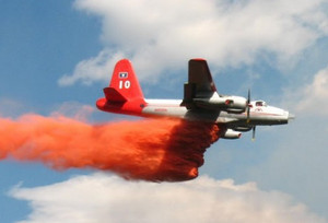
A slurry bomber drops retardant on the Fourmile Canyon Fire. (USFS)
A slurry bomber drops retardant on the Fourmile Canyon Fire. (USFS) View more images in the slideshow below.

Much like words have been used to tell the story of the Fourmile Canyon Fire and its destructive power, so too have photos and video.  The U.S. Forest Service has released new photos taken by their crews that tell the story in a way that hasn’t been seen yet – from behind the fire lines. 

On Monday the Fourmile Canyon Fire quickly exploded and soon smoke covered the Denver metro areaVideo taken from a nearby mountain showed the orange glow of the flames as they advanced.  The ferocity of the fire was such that NOAA satellites captured images of the smoke as it traveled as far as Iowa. 

Over the week the fire became the worst in Colorado history in terms of the number of homes lost as 169 were destroyed.  Images taken by helicopter from above showed mountain properties reduced to cinder. 

The images taken by the U.S. Forest Service (USFS) are stunning testaments to the bravery of the firefighters on the scene.  Photos of chainsaw wielding combatants, slurry bombers dropping their bright red retardant, and fire raging next to roadways tell the story from behind the lines. 

You can view the new images by clicking on the slideshow image below. 

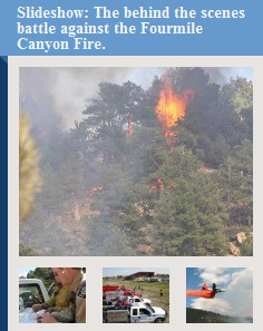
Slideshow: The behind the scenes battle against the Fourmile Canyon Fire. Below are links to other slideshows we published on Examiner.com over the past week.

Also be sure to check out these pages:

Do you remember? Please come to the City of Thornton’s September 11th Remembrance

Please join us as we remember those who died on September 11, 2001.

September 11, 2001 is a date which is forever etched in the memories of all Americans. The events of that horrible day serve as a reminder of the vigilance that we must maintain to defend our nation and the sacrifices that have been made to keep us safe.

In the wake of the attacks, each year the President of the United States designates September 11th as Patriot Day – a day of remembrance to ensure we never forget the men and women who died on that fateful today.

This year we invite everyone to please join us on the 9th anniversary of the attacks at the City of Thornton’s September 11th Remembrance Ceremony.

This event, a joint effort with the City of Thornton, The Thornton Police and Fire Departments, the Thornton Veterans of Foreign Wars and the Thornton Veterans Memorial Foundation, provides us an opportunity as a community to come together and honor the fallen.

The weather should be perfect so please join us at 9:30am on Saturday, September 11, 2010 at Thornton Community Park (2141 E. 95th Ave) for this special event.  The event will be held on the field at the east-most stage.

Fire burning in Fourmile Canyon sends smoke over Thornton

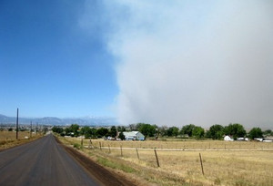
The Fourmile Canyon Fire sent smoke over Thornton on Monday. (ThorntonWeather.com)

A fast moving wildfire burning northwest of Boulder sent smoke over Thornton on monday and more is expected today.  The Fourmile Canyon Fire started late Monday morning and has burned 3,500 acres thus far. 

Tinder dry fuels, low humidity, warm temperatures and gusty winds fueled the Fourmile Canyon Fire yesterday as it grew quickly. Firefighters took up defensive positions trying to save what homes they could but many were reduced to cinder.

More than 100 firefighters are on scene with 35 engines from 30 local agencies. Boulder County Fire is acting as the primary agency for the fire.

High winds prevented air tankers with retardant from operating for most of the day but the wind eased in the late afternoon and evening allowing some operations. 18 flights by three tankers were carried out before the sun set and they were able to drop 40,000 gallons of retardant on the fast moving fire.

Four additional tankers arrived Monday and will begin operations today, weather permitting.

We are updating the Denver Weather Examiner with all the latest news and photos from the fire.  Please visit there for all the latest.

Weather, natural disasters & climate news and information.