June 10 to June 16 – This Week in Denver Weather History

This Week In Denver Weather History
June 10 to June 16 - This Week in Denver Weather History

Just as we saw in the past week, we are entering the primetime of Colorado’s severe weather season. Our look back at Denver weather history for this week shows numerous damaging, dangerous and deadly weather events.

From the National Weather Service:

9-10

In 1864…high water from melting snow combined with heavy rains over the upper reaches of the South Platte River forced the river over its banks and caused flooding of low lying areas along the river in the city. The amount of rainfall in the mountains and in the city is unknown.

10

In 1943…a man was killed by lightning while using a surveying instrument at Buckley Field.

In 1969…hail stones 2 to 3 inches in diameter caused extensive damage to buildings and automobiles in an area from northeast of Boulder to Longmont. Two funnel clouds were reported near Castle Rock. A funnel cloud and 1 inch hail stones were reported 10 to 20 miles southeast of Stapleton International Airport. Hail stones to 1 3/4 inches fell 3 miles west of Littleton. Hail to 3/4 inch diameter fell over southeast Denver.

In 1988…thunderstorm winds clocked to 60 mph unroofed a porch and downed a fence at a home near Stapleton International Airport. A small tornado touched down briefly in northeast Aurora. Another small tornado touched down for 3 minutes in southeast Aurora. No damage was reported from either twister.

In 1989…a national weather service observer saw lightning strike 2 storage tanks at 40th and Havana…3/8 mile northeast of Stapleton International Airport. The strike temporarily knocked out some weather observing equipment at the national weather service.

In 1991…a tornado was sighted 2 miles south of Castle Rock. No damage was reported. The funnel cloud associated with the tornado was sighted for 5 minutes by National Weather Service observers at Stapleton International Airport.

In 1994…lightning struck a home in Denver…which started a fire in the attic and caused minor damage.

In 1997…lightning struck a security guard at the castle pines golf course near Castle Rock. He received only minor injuries.

In 1999…severe thunderstorms rolled off the foothills over metro Denver…producing large hail and damaging winds. Hail to 1 inch diameter fell near Evergreen with 1 3/4 inch hail measured west of Golden. Hail to 1 1/2 inches fell in Commerce City with one inch hail in Lakewood…wheat ridge… The city of Denver and at Denver International Airport where thunderstorm winds gusted to 58 mph. As the storms moved east…3/4 inch hail was reported in Aurora…and damaging thunderstorm winds developed between Bennett and Strasburg. Winds gusting as high as 69 mph blew half a metal roof from a shed in a Bennett lumberyard. A small barn was also leveled between Bennett and Strasburg. Winds also gusted to 58 mph near Manilla.

In 2000…a dry microburst produced a wind gust to 58 mph at Jefferson County Airport. Thunderstorm winds gusted to 55 mph at Denver International Airport.

In 2003…hail as large as 1 3/4 inches was measured at centennial airport and near Parker.

In 2005…hail to 7/8 inch in diameter was reported near Parker with 3/4 inch hail measured near Castle Rock.

In 2009…lightning struck an apartment complex…a veterinary hospital in Boulder and caused minor damage. Lightning also struck two oil tanks…one in Boulder and the other at Front Range airport north of Watkins. The oil tanks in both instances were set on fire and suffered extensive damage.

In 2010…a complex of severe thunderstorms hammered portions of eastern Arapahoe…eastern Douglas and western Elbert counties. The hail ranged from 1 inch to 3 inches in diameter. The largest hail was observed near Elizabeth. Areas in and around Aurora…Byers…Parker and Thornton were also impacted by large hail. One weak tornado touched down near prospect valley but did no damage. At Denver International Airport…a peak wind gust to 35 mph was observed from the northwest.

10-11

In 1882…heavy thunderstorm rains on the morning of the 10th caused a rapid rise in Dry Creek…which enters the South Platte River at Fairview in present day south Denver. This…combined with additional heavy rainfall on the 11th caused the South Platte River to overflow. Five people drowned and several houses were destroyed. Total losses in the city and suburbs was estimated at 75 thousand dollars. Total rainfall in central Denver was 2.21 inches over the 2 days.

Continue reading June 10 to June 16 – This Week in Denver Weather History

Second day of storms miss Thornton so ThorntonWeather.com goes on the chase

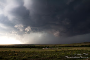
A massive storm churns near Simla, Colorado on Thursday, July 7, 2012. See more photos in the slideshow below.

Mother Nature brought severe weather to northeastern Colorado again yesterday but for the second day in a row Thornton missed out on the action.  Since the storms wouldn’t come to us, ThorntonWeather.com went to the storms.

Thornton seems to be in a bit of a ‘storm drought’ of late with most thunderstorms passing us by and yielding little more than a few rain drops.  Elsewhere along the Colorado Front Range the story has been much different over the last two days.

The setup was near perfect thanks to the formation of a Denver cyclone with moist air pulling in from the south meeting dry air from the north.

ThorntonWeather.com took off in mid-afternoon and headed east to Bennett, then on to Byers and east on Highway 36.  The initial storm cell that was beginning to take shape broke in to three and decisions had to be made on which one to follow.

The southernmost cell seemed to hold the most promise so we headed south, through Limon and tracked the storm near Simla.

The storm would drop tennis ball size hail and push out wind gusts measured at 80mph.  As many as four tornadoes were reported to have been caused by the storm, a number which will be confirmed and finalized later today.

In Elbert County, emergency agencies are conducting damage assessments from at least one of the twisters that tore through the central part of the county.  Extensive damage to as many as seven homes west of Simla was seen.  One person received minor injuries.

Thursday’s storms were the second day in a row for severe weather in the area.  On Wednesday thunderstorms brought massive amounts of hail to the southern Denver metro area and Colorado Springs.  Tornadoes were also spawned although there was no damage from the twisters.

  • Stay up to date with Thornton’s weather: ‘Like’ us on Facebook, follow us on Twitter and add us to your Google+ circles

Denver sets new record high temperature for June 4

Record setting high temperatures in Thornton.
Denver set a high temperature record of 94° on Tuesday, June 4.

As officially measured at Denver International Airport, the Mile High City hit a high temperature of 94° at 2:25pm. This broke the old record high temperature for the date of 93° set in 2010, 1990 and 1977.

The problem? No other reliable station in the metro area came anywhere near that high of a temperature reading.

For comparison, Rocky Mountain Regional Airport saw 91°, Centennial 88°, Boulder 91°, Denver City Park 90°, Stapleton 90° and here in Thornton we recorded 91°.

Once again we see how the move of Denver’s official monitoring station to DIA are altering our climate records.  For more details on this controversial topic: The fallacy of Denver’s climate records: Weather station move skews data

June 3 to June 9 – This Week in Denver Weather History
This Week In Denver Weather History
June 3 to June 9 - This Week in Denver Weather History

Severe weather season in Colorado gets started in earnest in June and we see that in our look back at this week in Denver weather history. Probably the most notable event for Thornton residents was the infamous 1981 Thornton tornado.

From the National Weather Service:

1-4

In 1977…unusually warm weather for this early in June resulted in 3 maximum temperature records being equaled at the time: 88 degrees on the 1st…90 degrees on the 2nd… And 93 degrees on the 4th. Maximum of 91 degrees on the 3rd was not a record.

2-4

In 1989…heavy rain drenched metro Denver with the greatest amounts recorded on the 3rd. Total rainfall ranged from 1 1/2 to 3 inches. Roads were washed out in Boulder County… And flooded basements caused water damage to houses in the Gunbarrel section of Boulder. In suburban Denver…heavy rain caused minor flooding along Lena Gulch in Jefferson County where two mobile home parks were evacuated. Rainfall totaled 1.66 inches at Stapleton International Airport.

2-7

In 1921…heavy rainfall for nearly a week…on top of streams already swollen by mountain snowmelt…produced widespread flooding over the South Platte River basin…including the tributaries through the canyons to the west and southwest of Denver. Heavy rainfall over the 6-day period totaled 3.36 inches in Boulder…4.98 inches in Morrison…4.27 inches in Castle Rock…and 2.94 inches in the city of Denver. Rainfall amounts in the foothills were estimated between 3 and 6 inches. The narrow-gage tracks of the Colorado and southern railroad were destroyed in the Platte Canyon. From the mouth of the canyon through the city to near Brighton… The river spread from 1/2 to nearly 1 1/2 miles wide… Flooding farm and pasture land and destroying or damaging many bridges. In the city…many businesses along with as many as 500 homes were inundated…forcing their evacuation. Bridges were swept away. The high waters flooded the rail yards and stock yards in lower downtown…closing three adjacent packing houses. The heavy rains also caused flooding on Boulder creek in Boulder on the 6th.

3

In 1951…a trace of snow fell at Stapleton Airport.

In 1961…torrential rains fell 10 to 30 miles north of Denver…causing flooding in the town of Frederick. The rush of water broke through and over a retaining dike sending a 5-foot wall of water into the town…flooding homes and damaging sewer lines…roads…and streets. Golf ball size hail fell in derby…west Denver…and Lakewood…causing more than one million dollars in damage.

In 1981…severe thunderstorms produced tornadoes over metro Denver. The first tornado touched down at the intersection of Alameda Ave. and Sheridan Blvd. The twister moved north along Sheridan Blvd….damaging businesses…apartment buildings…homes…and vehicles. Over ten homes were unroofed. The roof of one landed in the middle of a neighborhood park. At least 10 mobile homes were wrecked. The tornado curved to the northeast into northwest Denver… Hopping up and down in several places. Very strong winds outside the actual funnel caused 20 to 30 thousand dollars in damage in downtown Denver. The third floor of one old building was demolished. No major injuries were reported from the tornado…although several people were hurt slightly in traffic accidents on Sheridan Blvd. In the confusion caused by the storm. Damage in Lakewood alone was estimated at 200 thousand dollars. At the same time… The worst tornado to ever hit metro Denver struck Thornton. Coming from the same thunderstorm that spawned the Denver twister…the Thornton tornado tore a swath through the heart of the city. 87 homes were destroyed…110 others damaged at least moderately. In all…600 homes in a 100 block area sustained some damage. The twister also hit shopping centers…several restaurants…and other buildings. Seven of the 42 injured were considered serious. The storm was strong enough to snap lamp posts in half and drive a 6- inch slab of wood 2 feet into the ground. Damage was estimated at up to 50 million dollars. The same storm that struck Thornton produced another damaging tornado that touched down in the northwest section of Fort Lupton. This twister damaged 16 homes and numerous cars and campers. Two children were slightly injured when the car they were in was knocked about and its windows shattered by the storm. The twister also damaged two commercial buildings. Damage was very spotty…and observers said the storm hopped up and down at least 3 times. Dollar damage was estimated at 500 thousand dollars. The thunderstorm complex that produced 3 damaging tornadoes also dropped large hail which damaged many cars over northwest Denver. One to 2 inches of rain fell in less than an hour…flooding a mobile home park with 3 to 4 feet of water on the northwest edge of Denver. The high water damaged about half of the 392 homes in the park. Local flooding was also reported in other areas across metro Denver. A tornado was also sighted near Franktown…but caused no damage. A thunderstorm wind gust to 52 mph was recorded at Stapleton International Airport.

In 1982…a cold air funnel cloud touched down briefly in southwest Denver. Two tornadoes were briefly spotted near Watkins. No damage was reported from these storms. A brief funnel cloud was sighted by national weather service observers at Stapleton International Airport where 1/4 inch hail fell.

In 1984…there were several sightings of tornadoes around Parker. No damage was reported.

In 1985…a tornado just southeast of Aurora was spotted by a national weather service employee. No damage was reported. Severe thunderstorms pummeled the metro area with hail. One inch to baseball size hail was reported in south Lakewood…one inch hail in Littleton…3/4 inch to 1 inch hail in Aurora…and golf ball size hail in south Denver.

In 1989…hail up to golf ball size fell over Arvada. A golf course had to be evacuated as the hail accumulated up to 3 inches deep in some places. One inch diameter hail fell in west Denver and Westminster.

In 1993…an early morning thunderstorm produced lightning… Which caused an attic fire at a residence in Niwot northeast of Boulder. Damage was estimated at 40 thousand dollars. No one was injured.

In 1994…hail to 1 1/2 inch diameter fell just northeast of Boulder. One inch diameter hail fell in Golden. Thunderstorm wind gusts to 70 mph were recorded in Erie.

In 1995…a tornado was sighted over open country near Strasburg. No damage was reported. A funnel cloud was sighted 11 miles east of Aurora where 3/4 inch hail fell.

In 2001…severe thunderstorms produced large hail over east and southeast metro Denver. Hail as large as 1 3/4 inches in diameter fell at centennial airport with 1 1/2 inch hail near Buckley Field…1 1/4 inch hail in Parker…1 inch hail near Elizabeth…7/8 inch hail at Cheery Creek Reservoir…and 3/4 inch hail 20 miles north of Kiowa in Elbert County.

In 2002…severe thunderstorms dumped large hail across metro Denver. Hail to 1 3/4 inches in diameter fell over southeast Denver and 4 miles north of Aurora. Hail to 1 1/4 inches pelted Parker. One inch hail was measured near Ft. Lupton…and 3/4 inch hail fell 9 miles southeast of Buckley Field…near Strasburg…and at the site of the former Stapleton International Airport.

In 2005…thunderstorms producing heavy rain and hail caused flash flooding over parts of southeast metro Denver. People became trapped in their vehicles by the high water… And numerous water rescues were required. The hardest hit areas included the vicinity of I-25 and Alameda Avenue…as well as the intersection of Yale Avenue and Quebec Street. Several basements were flooded along Eastman Place. Severe thunderstorms brought heavy rain and hail to eastern centennial and southeastern Aurora. Up to 3 feet of standing water was reported on east orchard road where several motorists were stranded in their vehicles and needed to be rescued. Hail to 3/4 inch in diameter fell in the area. Ten vehicles were stranded on Grand Avenue…and most had to be towed once the floodwaters receded. Water was reportedly chest deep at one location on Girard Avenue. Hail as large as 3/4 inch in diameter also was reported in Littleton…near Parker…and near Buckley Air Force Base. Hail to 7/8 inch was measured near Sheridan and Cheery Creek Reservoir.

Continue reading June 3 to June 9 – This Week in Denver Weather History

May 27 to June 2 – This Week in Denver Weather History

This Week In Denver Weather History
May 27 to June 2 - This Week in Denver Weather History

A very eventful week in Denver weather history with everything from thunderstorms and tornadoes to yes, even snow.

From the National Weather Service:

20-27

In 2002…lightning sparked a wildfire near Deckers. Extremely dry conditions and very strong winds the following day allowed the fire…known as the Schoonover…to consume 3850 acres before it could be contained. Thirteen structures were destroyed…including 4 homes…resulting in 2.2 million dollars in damage.

26-31

In 1995…a cool period with light morning showers and moderate to heavy afternoon showers and thunderstorms pushed rivers already swollen from mountain snow melt over their banks causing minor flooding. Streams and rivers such as the South Platte and Boulder Creek flooded meadowlands…bike paths…roads near streams…and other low lying areas. No significant property damage was reported and crop damage was unknown. Rainfall totaled 1.79 inches at the site of the former Stapleton International Airport and only 1.51 inches at Denver International Airport.

27

In 1874…an apparent thunderstorm gust front reached the city at 6:40 pm. Strong southwest winds sustained to 48 mph for a few minutes produced large columns of dust in the city and on the prairie. There was no rain in the city.

In 1942…a duststorm swept into the city…but no damage was reported. West winds were sustained to 23 mph.

In 1953…a heavy hailstorm caused an estimated 100 thousand dollars damage across metro Denver. Larger than golf ball size hail fell in Westminster and north Denver. Only 1/8 inch hail was measured at Stapleton Airport.

In 1955…west-northwest winds at 35 mph with gusts as high as 58 mph briefly reduced the visibility to 1/2 mile in blowing dust at Stapleton Airport.

In 1981…lightning damaged power lines west of Lakewood and blew up a transformer at the Denver Federal Center. Hail 1 to 1 1/2 inches in diameter was reported in Lakewood and on I-25 south of Denver.

In 2001…hail as large as 3/4 inch in diameter was measured near Commerce City.

In 2003…hail to 3/4 inch in diameter fell near Central City.

In 2006…unusually warm weather for late May produced two temperature records. The high temperature of 93 degrees was a record maximum for the date. The low temperature of 59 degrees equaled the record high minimum temperature for the date. Both previous records occurred in 1895.

Continue reading May 27 to June 2 – This Week in Denver Weather History

Weather, natural disasters & climate news and information.