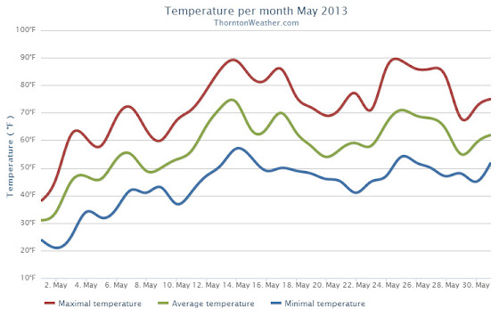
Following on colder and wetter than normal weather in previous months, Thornton’s May returned us to drier and warmer than normal conditions.
The month started out with a bit of a wintry blast of cold temperatures and snow. In fact, Denver even set an all-time May low temperature on the 2nd of the month.
The cold and snow that started the month were probably overall the most notable feature of the month. The rest of May was not particularly extraordinary in any aspect.
Denver’s average temperature for the month was 57.9 degrees. This was 0.8 degrees above average. Here in Thornton we were just slightly cooler with an average temperature of 57.6 degrees.
Thornton’s temperatures ranged from a high of 89.2 degrees on the 14th down to a low of 20.7 degrees on the morning of the 2nd. Denver saw a maximum temperature of 88 and a low of 19 degrees.
Official Denver temperature records for the month included:
DAILY RECORDS:
DATE TEMPERATURE TYPE OF RECORD OLD RECORD YEAR LAST SET
MAY 2ND 19 DEGREES RECORD LOW 22 DEGREES 1954
MAY 14TH 87 DEGREES TIED RECORD HIGH 87 DEGREES 1996
MONTHLY RECORDS:
DATE TEMPERATURE TYPE OF RECORD OLD RECORD YEAR LAST SET
MAY 2ND 19 DEGREES TIED RECORD LOW 19 DEGREES MAY 3RD 1907
In terms of precipitation, Denver recorded only 0.82 inches, far below the average for May of 2.12 inches. Here in Thornton Mother Nature was far more generous as we recorded 2.35 inches.
The snow that started the month totaled 4.3 inches in Thornton, 3.4 inches in Denver. Both were well above the May average of 1.1 inches snowfall.
Three men who had dedicated themselves to furthering the knowledge and science of severe weather were among those killed Friday in a deadly twister that struck El Reno, Oklahoma. Tim Samaras, his son Paul, and their chase partner Carl Young, were well-known within the weather enthusiast community but also known to many Americans following their appearance on a television show. Read the rest of this story on Examiner.com
Storm chasers Tim Samaras (R) and Carl Young (L) are seen in this promotional image from Discovery Channel. Both men were killed in Friday’s tornado outbreak. Click the image to view a slideshow of images from the event.
One of our favorite pastimes is simply watching the clouds. Colorado’s widely varying weather provides a stunning variety in almost every season. One photographer captured an amazing time lapse video of what he called “Bubbly Rocky Mountain Clouds.”
Storm chaser and IMAX film maker Sean Casey and his team captured what is arguably the most extraordinary video taken from inside a tornado ever. From inside the relative safety of their Tornado Intercept Vehicle (TIV), the team was able to enter a monstrous wedge tornado near Smith Center, Kansas yesterday. Read the rest of this story and watch the amazing video on Examiner.com
A screengrab from video taken from inside the TIV2 shows a piece of debris sparking across the vehicle’s windshield as it sits inside of a tornado in Kansas on Monday, May 27, 2013. (YouTube / Brandon Ivey). Click to watch the video.
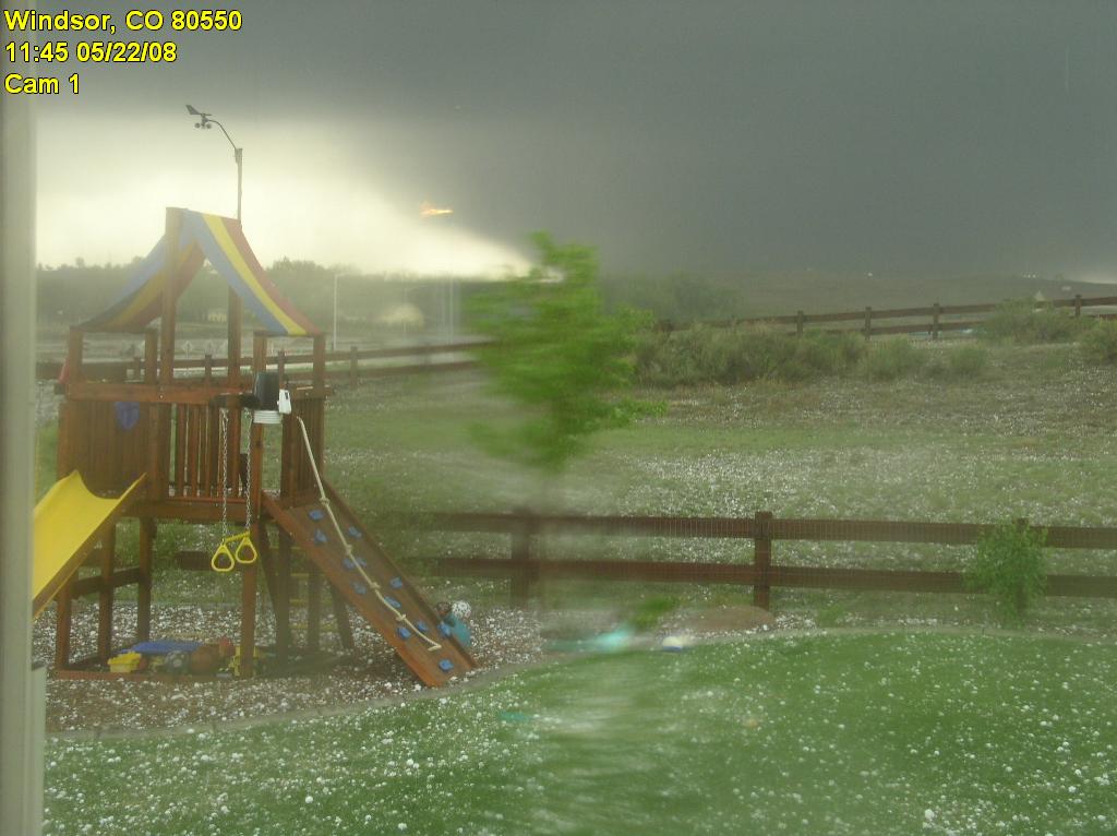
The May 22, 2008 Windsor, Colorado Tornado was captured by a webcam. (MyWindsorWeather.com)
A fast moving jet stream coupled with quickly rising temperatures and unusually high humidity ripened conditions for what we now simply call the ‘Windsor tornado.’ Soon after 11:00am that morning a monstrous supercell thunderstorm could be seen erupting to the north of the Denver area.
Tornado warnings were soon issued by the National Weather Service and a Gilcrest police officer radioed, “We have a tornado on the ground!”
Indeed this was no ordinary Colorado tornado. This was to become an EF-3 monster three quarters of a mile wide and packing winds up to 165 mph, an event more associated with the plains of Oklahoma.
Over the course of 35 miles and 45 minutes the tornado ripped through the landscape. Making the event all the more unusual was its movement to the northwest, far different than typical tornadoes which move to the northeast.
Day became almost as dark as night as the ominous wedge approached Windsor. Hail as large as softballs began to rain down.
At 11:57 a.m. the town became ground zero.
Scared residents rushed for safety as nature’s most violent phenomena arrived. Power poles were snapped like matchsticks, semi-trailers were overturned like toy cars, and homes and buildings were reduced to their basic building materials.
Windsor resident Jill Gallagher told the Windsor Beacon this week of her huddling in her basement with her daughters as the twister struck. After it passed, “That’s when I turned and looked up my stairwell, and that’s when I knew something had majorly happened.”
Gallagher said her stairs were blocked and she was staring up at blue sky instead of her home’s ceiling.
The power of the storm was fully evident in the toll on life and property.
One man was killed west of Greeley at Missile Silo Park Campground and 78 people were injured. Property damages totaled $193.5 million as nearly 300 homes were destroyed or significant damaged and another 850 sustained less substantial damage.
Lying on the western edge of the infamous Tornado Alley, twisters are quite commonplace in the Centennial State. From 1950 to 2012 there have been 1,983 tornadoes scattered across the state. Most though occur on the eastern plains, well away from the higher terrain of the west and the more populous Front Range. Only 20 of those have attained F3 strength.
Today, five years after that deadly day, a drive through Windsor would yield few signs of the tornado that caused so much devastation. The residents however are quick to remember it, particularly in light of the recent deadly tornadoes in Texas, Kansas and Oklahoma.
The devastation in Moore, Oklahoma is immense but amazing stories of survival are being seen. Click the image to watch a heartwarming video of a dog owner reunited with her beloved companion. (Getty Images)
The tornado that ripped through Moore, Oklahoma yesterday has claimed at least 91 lives and caused hundreds of injuries. As the death toll mounts, the twister will go down in history as one of the deadliest in U.S. history.
Editor’s note, 5/21/13, 9:23 a.m. MDT: Amy Ellis with the Oklahoma Medical Examiner has said that previous counts released by their office for lives lost as reported in this story were incorrect. The Medical Examiner said their office now puts the death toll at 24, 9 of which were children.
Forecasters had warned that Monday would bring dangerous severe weather, the third of a series of days in the past week that had been deadly. Warnings went out as the tornado formed near Newcastle and began its deadly trek to the northeast.
The minutes were crucial to saving lives but as the storm grew in ferocity, even the most robust shelters were proven incapable of withstanding the onslaught.
Cars marked with an orange ‘X’, denoting they had been checked for occupants, are piled up in what was the front entrance to the damaged Moore Medical Center after a powerful tornado ripped through the area on May 20, 2013 in Moore, Oklahoma. Click image to view a photo slideshow of the devastation. (Getty Images)
Scenes of devastation were being played out south of Oklahoma City Monday evening in the wake of a massive tornado that ripped through the suburb of Moore. Packing winds up to 200 mph, the twister tore through the landscape leaving little but rubble behind. At least 51 people have been confirmed dead and the death toll is expected to climb. Read the rest of this story on Examiner.com
Scenes of destruction in Moore, Oklahoma are captured in this screen grab of a Vine video by a local resident. (Vine / David Massey). Click to watch storm chaser video of the tornado.
Weather, natural disasters & climate news and information.