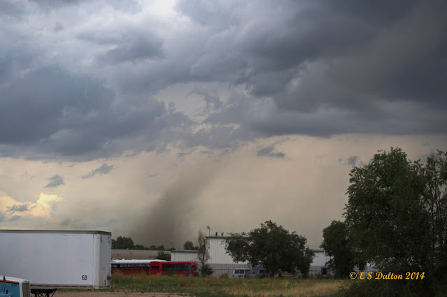
July 28, 2014 – Image of the tornado at the Rocky Mountain Arsenal. (Ed Dalton) Click for a larger view.
Monday’s forecast called for a chance for thunderstorms but Mother Nature threw in a couple of wildcards in the form of two tornadoes in the area. The landspout tornadoes caused minor damage in north Denver and were widely seen across much of the area.
The first tornado was reported at 3:53pm just across the Adams County line in Weld County near Fort Lupton. The twister was the better defined of the two but appears to have struck farmland with no damage reported.
Videos: Watch amazing footage of the Weld County tornado below
At 4:09pm a second tornado was reported near the Rocky Mountain Arsenal National Wildlife Refuge in Adams County. A diesel repair shop near 51st and Havana had one of its garage doors ripped off and some material thrown about.
Denver International Airport sent travelers to shelters for a period of time and warning sirens were sounded in Brighton, Commerce City and other nearby locations.
Three people on a small boat on Barr Lake were overturned by the strong thunderstorm winds. The trio managed to swim to shore and were not injured.
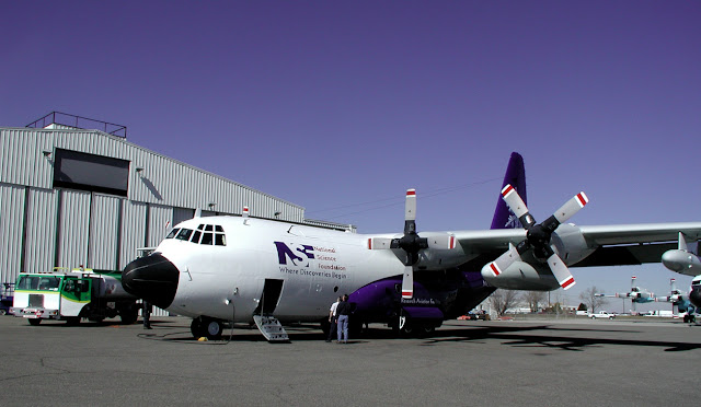
Over the past week you may have noticed a relatively persistent ‘drone’ of aircraft over the Denver area and seen a relatively large aircraft flying overhead. The plane is a specially outfitted C-130 taking part in a major field study of the Front Range’s ozone.
Scientists at the National Center for Atmospheric Research (NCAR) will be using the aircraft, radar, balloons and other sensors and systems in the coming weeks. The project has many goals including mapping possible sources of ozone pollution and using the data to better interpret satellite data.
SCIENTISTS LAUNCH FAR-RANGING CAMPAIGN TO DETAIL FRONT RANGE AIR POLLUTION
BOULDER – Scientists at the National Center for Atmospheric Research (NCAR) and partner organizations are launching a major field project across the northern Front Range of Colorado this month to track the origins of summertime ozone, an invisible but harmful pollutant.
The researchers will use specially equipped aircraft, mobile radars, balloon-mounted sensors, and sophisticated computer simulations to measure local and far-flung pollution sources. Results from the month-long study will provide needed information to officials seeking to ensure that air in the region is healthy to breathe.
It marks one of the largest research projects to look at summertime air pollution on the northern Front Range, including Denver, which often exceeds federal standards for safe levels of ground-level ozone pollution despite efforts to reduce emissions. Ozone can lead to increased asthma attacks and other respiratory ailments. It also damages vegetation, including crops.
“Our goal is to produce an accurate and detailed view of all the diverse sources of ozone pollution along the Front Range,” said NCAR scientist Gabriele Pfister, a principal investigator on the project. “We want to fingerprint where the pollution comes from and analyze what happens when it mixes in the atmosphere.”
Known as the Front Range Air Pollution and Photochemistry Experiment (FRAPPÉ), the study will track emissions from both human-related activities and natural sources. It will focus on the urban corridor from south of Denver, north to Fort Collins, as well as the adjacent plains and mountains. Scientists also want to determine how much pollution comes from upwind areas, including other states and countries.
Funded through a federal-state partnership, FRAPPÉ is supported by the Colorado Department of Public Health and Environment and by the National Science Foundation, which is NCAR’s sponsor.
TWO MAJOR PROJECTS CONVERGE
To provide additional detail across the region, scientists will closely coordinate FRAPPÉ with a second air quality mission taking place on the Front Range at the same time. DISCOVER-AQ (Deriving Information on Surface Conditions from Column and Vertically Resolved Observations Relevant to Air Quality) is a major study led by NASA that seeks to improve the ability of satellites to usefully assess our air quality.
“What we learn from these flights will help us to better interpret satellite remote sensing of air quality from geostationary orbit in the future,” said NASA scientist Jim Crawford, a principal investigator on DISCOVER-AQ. “It also will help us to define the best combination of instruments on the ground to connect air quality monitoring networks with satellite information.”
The DISCOVER-AQ flights and ground observations will focus on the northern Front Range, while FRAPPÉ will gather measurements from the surrounding region.
In all, approximately 200 scientists, technicians, pilots, and students from around the country will converge on the Front Range for the combined projects.
The researchers will quantify emissions from industrial facilities, power plants, motor vehicles, agricultural operations, oil and gas drilling, fires, and other sources. They also will measure naturally occurring emissions from trees and other plants that then combine with emissions generated by human activity to form ozone and other pollutants.
PROFILING AIR QUALITY IN THREE DIMENSIONS
Colorado, like other states, relies on a limited number of ground-based stations to monitor air quality and help guide statewide policies and permitting. But a full, three-dimensional picture of the processes that affect air quality, including conditions far upwind and high up in the atmosphere, requires a three-pronged approach with measurements from aircraft, satellites, and the ground.
“By bringing together aircraft, satellites, and ground-based instruments, we can analyze the amounts and types of pollutants that are emitted in the Front Range as well as transported from other places, how they evolve, and how air circulation patterns near the mountains move them around,” said NCAR scientist Frank Flocke, a principal investigator on FRAPPÉ.
During the projects, which run from July 16 to mid-August, Front Range residents may notice occasional low-flying research aircraft that are taking measurements of the atmosphere. The aircraft will spiral down at times, taking samples of air as they spiral directly above ground instruments that will be measuring air at the surface and observing the atmosphere above.
Ozone, a principal component of smog, forms from the reaction of hydrocarbons and carbon monoxide in the presence of nitrogen oxides (NOx) and sunlight. It peaks during summer months when sunlight is strongest and air conditions are more likely to be stagnant.
Although the scientists will focus on ozone, they will also measure the size and chemical composition of airborne particles to better quantify particle pollution and track its sources. Microscopic airborne particles can have a major impact on people’s respiratory health.
The data gathered by the projects will go through a quality assurance process and then become publicly available in about six months. Scientists will use the data to begin publishing research results in about a year.
AN ARMADA OF INSTRUMENTS
FRAPPÉ and DISCOVER-AQ will use similar payloads for their aircraft. The teams will conduct wingtip-to-wingtip intercomparison flights several times during the project, sampling air in the same place to make sure the instrument readings are comparable.
A network of instruments on towers, rooftops, and other sites will continuously monitor ozone and the gases that react to form it. Other ground-based activities, such as measurements from tethered balloons and from lidars (laser-based radars), will be closely coordinated with the flights. The researchers will draw on forecasts and nowcasts of both weather and air quality from a large number of computer models to assess daily conditions and make final decisions on when to fly and where to gather atmospheric samples.
“This is a unique opportunity for the state to work with others on a study that combines ground-based measurements with aircraft-borne sensing,” said Will Allison, director of the Colorado Department of Public Health and Environment’s Air Pollution Control Division. “It will help us more fully understand complex questions such as the factors contributing to ozone formation in the region. And that will help us continue to implement effective measures to reduce air pollution.”
“FRAPPÉ is a major collaborative study that will produce the most complete picture ever of summertime air pollution on the Front Range,” said Thomas Bogdan, president of the University Corporation for Atmospheric Research, which manages NCAR. “This effort will dramatically advance our understanding of air quality and its potential impacts. The results have the potential to help not only people living on Colorado’s Front Range, but residents of other metropolitan areas with similar conditions, too.”
In addition to NCAR and the Colorado Department of Public Health and Environment, the FRAPPÉ team includes scientists from the National Oceanic and Atmospheric Administration; Cooperative Institute for Research in Environmental Sciences; National Park Service; Regional Air Quality Council; Global Ozone Project; Western Regional Air Partnership; Environmental Protection Agency; University of Colorado Boulder; Colorado State University; University of California, Berkeley; University of Wisconsin; University of Cincinnati; Georgia Institute of Technology; University of California, Riverside; Aerodyne Inc.; U.S. Naval Academy; University of Rhode Island; University of California, Irvine; and Princeton University.
The twin terrors of the June 16, 2014 tornadoes near Pilger and Wisner, Nebraska were captured on video. (YouTube / Timothy Klaustermeier)
Severe weather struck eastern Nebraska on June 16 spawning an amazing four EF-4 rated tornadoes in less than an hour. Two of these were twins, formed from the same supercell thunderstorm at nearly the same time, and stunning video from a resident’s porch shows the beasts.
While this event and the video are a few weeks old, it is well worth sharing. The imagery is a stunning display of Mother Nature’s most violent phenomena.
Timothy Klaustermeier took the video and posted it to YouTube. The nearly seven minute long video shows both tornadoes that spawned near Pilger and lifted north of Wisner. Amazingly the man appears to have been quite calm during the event as the only sounds heard are the roaring of the twisters.
Two other twisters in the same area, one just before and one just after the twins, were also rated EF4s.
Extensive damage was seen in the areas of Pilger and Wisner. Two fatalities were recorded: A five year old girl and a 75 year old man. Sixteen people were critically injured in the storms.
All-in-all, while temperatures and precipitation rain a bit lower than average, June 2014’s weather was pretty close to what we typically expect to see. Thunderstorms made their appearances as always but we were spared much in the way of severe weather.
A series of fronts and troughs moved through northern Colorado during the month. This helped to keep temperatures down and provided thunderstorms with a bit of regularity.
Thornton’s average temperature for the month came in at 66.5 degrees. This is less than one degree below Denver’s historical June average of 67.4 degrees. The Mile High City’s average came in slightly warmer at 67.3 degrees.
Temperatures in Thornton ranged from a high of 92.1 degrees on June 3rd down to a low of 38.2 degrees on the morning of the 9th. Denver was warmer on both measurements with a maximum reading of 94 degrees on the 26th and a low of 42 degrees on the 15th.
Six days saw temperatures top the 90 degree mark in Thornton and Denver. This is below the historical average of 7.9 days of 90 degree or warmer readings we expect to see.
No temperature records were set during the month.
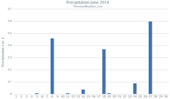
In terms of precipitation, Thornton had 1.59 inches fall into our rain bucket. Denver was a bit wetter with 1.82 inches. Both fell below the June average of 1.98 inches. Thornton saw eight days with measurable precipitation, Denver nine.
Denver set a daily precipitation record of 0.51 inches on the 27th. This bested the old record for that date of 0.29 inches in 1949. Thornton recorded 0.60 inches on the same day.
Thornton, Colorado temperature summary for June 2014.Thornton, Colorado precipitation summary for June 2014.
...THE DENVER CO CLIMATE SUMMARY FOR THE MONTH OF JUNE 2014...

CLIMATE NORMAL PERIOD 1981 TO 2010
CLIMATE RECORD PERIOD 1872 TO 2014

WEATHER         OBSERVED          NORMAL  DEPART  LAST YEAR`S
                 VALUE   DATE(S)  VALUE   FROM    VALUE  DATE(S)
                                          NORMAL
................................................................
TEMPERATURE (F)
RECORD
 HIGH             105   06/26/2012
                        06/25/2012
                        54/01/2206
 LOW               30   06/02/1951
HIGHEST            94   06/26
LOWEST             42   06/15
AVG. MAXIMUM     83.4              82.4     1.0     87.8
AVG. MINIMUM     51.2              52.3    -1.1     54.3
MEAN             67.3              67.4    -0.1     71.1
DAYS MAX >= 90      6               7.9    -1.9       14
DAYS MAX <= 32      0               0.0     0.0        0
DAYS MIN <= 32      0               0.0     0.0        0
DAYS MIN <= 0       0               0.0     0.0        0

PRECIPITATION (INCHES)
RECORD
 MAXIMUM         4.96   1882
 MINIMUM            T   1890
TOTALS           1.82              1.98   -0.16     0.75
DAILY AVG.       0.06              0.07   -0.01     0.03
DAYS >= .01         9               8.4     0.6        4
DAYS >= .10         5               4.6     0.4        2
DAYS >= .50         1               1.4    -0.4        1
DAYS >= 1.00        0               0.3    -0.3        0
GREATEST
 24 HR. TOTAL    0.51   06/27 TO 06/27           06/23 TO 06/23
                        06/26 TO 06/27                    06/22 TO 06/23
                        06/27 TO 06/27                    06/23 TO 06/23
 STORM TOTAL       MM                                 MM
 (MM/DD(HH))            MM                    06/23(00) TO 06/23(00)
                                                 06/23(00) TO 06/23(00)3
                                                 06/23(00) TO 06/23(00)3

SNOWFALL (INCHES)
RECORDS
 TOTAL             MM   MM
TOTALS            0.0               0.0

DEGREE_DAYS
HEATING TOTAL      30                62     -32       29
 SINCE 7/1       6004              6058     -54     6084
COOLING TOTAL     106               133     -27      221
 SINCE 1/1        127               155     -28      263

FREEZE DATES
RECORD
 EARLIEST     09/08/1962
 LATEST       06/08/2007
EARLIEST      10/04             10/07
LATEST        05/14             05/05
....................................................

WIND (MPH)
AVERAGE WIND SPEED              10.5
RESULTANT WIND SPEED/DIRECTION   3/148
HIGHEST WIND SPEED/DIRECTION    39/300    DATE  06/18
HIGHEST GUST SPEED/DIRECTION    55/220    DATE  06/18

SKY COVER
POSSIBLE SUNSHINE (PERCENT)   MM
AVERAGE SKY COVER           0.50
NUMBER OF DAYS FAIR            8
NUMBER OF DAYS PC             21
NUMBER OF DAYS CLOUDY          1

AVERAGE RH (PERCENT)     53

WEATHER CONDITIONS. NUMBER OF DAYS WITH
THUNDERSTORM              0     MIXED PRECIP               0
HEAVY RAIN                3     RAIN                       3
LIGHT RAIN               12     FREEZING RAIN              0
LT FREEZING RAIN          0     HAIL                       3
HEAVY SNOW                0     SNOW                       0
LIGHT SNOW                0     SLEET                      0
FOG                       7     FOG W/VIS <= 1/4 MILE      4
HAZE                      4

-  INDICATES NEGATIVE NUMBERS.
R  INDICATES RECORD WAS SET OR TIED.
MM INDICATES DATA IS MISSING.
T  INDICATES TRACE AMOUNT.
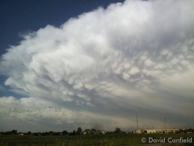
Impressive thunderstorms are a hallmark of Colorado’s June weather. (David Canfield)
The month of June typically sees springtime severe weather reach its height of activity in northeastern Colorado.
This affords the opportunity to capture extraordinary images of amazing weather phenomena from monstrous supercell thunderstorms to heavy rain, hail and even tornadoes.
Slideshow updated June 30, 2014
Showcasing images captured by ThorntonWeather.com readers as well as some of our own, our monthly slideshow covers the entire gamut of weather-related imagery.
Sunsets, sunrises, wildlife and of course every type of weather condition are vividly depicted. June brings some very dynamic weather and the photos are a great way to see the stunning variety.
To learn more about how to send your photo to us for inclusion in the slideshow, see below the slideshow.
Click the play button below and sit back and enjoy the images.
What is missing in the slideshow above? Your photo!
Our monthly photo slideshow is going to feature images that we have taken but more importantly images that you have captured. The photos can be of anything even remotely weather-related.
Landscapes, current conditions, wildlife, pets, kids. Whimsical, newsy, artsy. Taken at the zoo, some other area attraction, a local park, a national park or your backyard. You name it, we want to see and share it!
Images can be taken in Thornton, Denver or anywhere across the extraordinary Centennial State. We’ll even take some from out of state if we can tie it to Colorado somehow.
We’ll keep the criteria very open to interpretation with just about any image eligible to be shown in our slideshows.
What do you win for having your image in our slideshow? We are just a ‘mom and pop’ outfit and make no money from our site so we really don’t have the means to provide prizes. However you will have our undying gratitude and the satisfaction that your images are shared on the most popular website in Thornton.
To share you images with us and get them included in the slideshow just email them to us or share them with ThorntonWeather.com on any of the various social media outlets. Links are provided below.
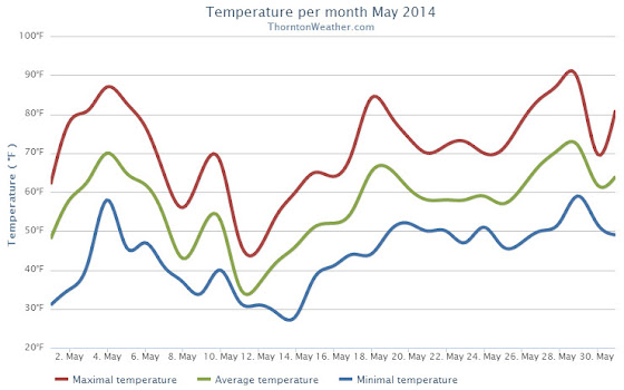
The month of May was a relatively benign, uneventful month in terms of the weather in Thornton. Average temperatures were right on par with normal while precipitation was generous.
We started out the month with warming temperatures and by the third we were seeing highs in the 80s. This only lasted a few days before cooler than normal temperatures settled in for a 10 day period.
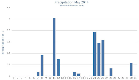
It was during that period that we recorded precipitation for six straight days. This included a good shot of snow on the 11th and 12th.
Temperatures bounced back on the 18th and 19th with highs above 80 degrees but then settled down again to predominantly cooler than normal conditions for the next week. The period from the 20th to the 25th also saw a return to wet conditions.
Warmer and dry conditions returned for a few days and then we closed out the month with cooler temperatures and some more rain.
Thornton finished the month with an average temperature of 56.9 degrees. This was just a hair lower than Denver’s May average of 57.1 degrees. The Mile High City’s average temperature came in warmer at 57.5 degrees.
The hottest temperature recorded occurred on the 29th with a reading of 88.7 degrees. The coldest temperature of 28.5 degrees was on the 14th. Denver’s warmest reading was 85 degrees on the 4th and its coldest of 30 degrees was on the 12th.
In terms of precipitation, Thornton saw a healthy 4.26 inches of liquid precipitation. This was well above the May average of 2.12 inches. Similarly, Denver saw above normal precipitation with a reading of 3.51 inches.
Snow fell on two days and totaled 4.3 inches in Thornton. Out at DIA, only 1.1 inches was recorded. Average snowfall for May in Denver is 1.1 inches.
Click here to view Thornton’s May 2014 climate report.
The Thornton, Colorado temperature summary for May 2014. (ThorntonWeather.com)
The Thornton, Colorado precipitation summary for May 2014. (ThorntonWeather.com)
CLIMATE REPORT
NATIONAL WEATHER SERVICE BOULDER, CO
642 AM MDT SUN JUN 1 2014

...................................

...THE DENVER CO CLIMATE SUMMARY FOR THE MONTH OF MAY 2014...

CLIMATE NORMAL PERIOD 1981 TO 2010
CLIMATE RECORD PERIOD 1872 TO 2014

WEATHER         OBSERVED          NORMAL DEPART LAST YEAR`S
                 VALUE   DATE(S) VALUE   FROM    VALUE DATE(S)
                                          NORMAL
................................................................
TEMPERATURE (F)
RECORD
 HIGH              95   05/26/1942
 LOW               19   05/02/2013
                        05/03/1907
HIGHEST            87   05/28        95      -8       88 05/17
                        05/29
LOWEST             30   05/12        19      11      19 05/02
AVG. MAXIMUM     70.6              71.5    -0.9     71.7
AVG. MINIMUM     44.5              42.7     1.8     44.1
MEAN             57.5              57.1     0.4     57.9
DAYS MAX >= 90      0               0.8    -0.8        0
DAYS MAX <= 32      0               0.0     0.0        0
DAYS MIN <= 32      4               1.9     2.1        4
DAYS MIN <= 0       0               0.0     0.0        0

PRECIPITATION (INCHES)
RECORD
 MAXIMUM         8.57   1876
 MINIMUM         0.06   1974
TOTALS           3.51              2.12    1.39     0.82
DAILY AVG.       0.11              0.07    0.04     0.03
DAYS >= .01        13               9.4     3.6        7
DAYS >= .10         6               4.8     1.2        3
DAYS >= .50         3               1.2     1.8        0
DAYS >= 1.00        1               0.2     0.8        0
GREATEST
 24 HR. TOTAL    1.39   05/20 TO 05/21              0.33 05/07 TO 05/08

SNOWFALL (INCHES)
TOTALS            1.1               1.1              3.4

DEGREE_DAYS
HEATING TOTAL     244               265     -21      253
 SINCE 7/1       5974              5996     -22     6055
COOLING TOTAL      21                21       0       42
 SINCE 1/1         21                22      -1       42

FREEZE DATES
RECORD
 EARLIEST     09/08/1962
 LATEST       06/08/2007
EARLIEST                        10/07
LATEST                          05/05
.........................................................

WIND (MPH)
AVERAGE WIND SPEED              10.6
RESULTANT WIND SPEED/DIRECTION   1/181
HIGHEST WIND SPEED/DIRECTION    37/330    DATE 05/21
HIGHEST GUST SPEED/DIRECTION    42/330    DATE 05/21

SKY COVER
POSSIBLE SUNSHINE (PERCENT)   MM
AVERAGE SKY COVER           0.70
NUMBER OF DAYS FAIR            3
NUMBER OF DAYS PC             18
NUMBER OF DAYS CLOUDY         10

AVERAGE RH (PERCENT)     55

WEATHER CONDITIONS. NUMBER OF DAYS WITH
THUNDERSTORM              0     MIXED PRECIP               0
HEAVY RAIN                2     RAIN                       6
LIGHT RAIN               17     FREEZING RAIN              0
LT FREEZING RAIN          1     HAIL                       1
HEAVY SNOW                0     SNOW                       2
LIGHT SNOW                2     SLEET                      1
FOG                      11     FOG W/VIS <= 1/4 MILE      3
HAZE                      3

- INDICATES NEGATIVE NUMBERS.
R INDICATES RECORD WAS SET OR TIED.
MM INDICATES DATA IS MISSING.
T INDICATES TRACE AMOUNT.
Extreme weather can occur during in month in Colorado we well know. June however is when traditional spring severe weather arrives in the state oftentimes with hail, damaging wind and tornadoes.
Over 40 percent of the tornadoes that occur in Colorado happen during the month of June. Far more common are thunderstorms with hail and wind, each responsible for extensive damage each year.
While severe weather is common, so too are brilliantly sunny and mild days as we close out spring and enter summer. If you are looking for cold, it isn’t likely but it is possible as the Denver area has seen freezing temperatures and yes, even snow, during the month.
June 3, 1981 – An F2 tornado rips through the heart of Thornton, Colorado. See more images in the slideshow below.(NCAR)
June 3, 1981 appeared to be a pretty typical late spring day in the Denver metro area. Afternoon thunderstorms though would become a ‘perfect storm’ and soon the city of Thornton would find itself witness to a tornado that would go down in the Denver weather history books.
Five tornadoes would strike that day but one would become the most infamous. The Thornton tornado would tear through what was then the heart of the city damaging homes and businesses and sending many residents to the hospital.
The twister initially touched down at 2:43 p.m. and ripped across 2 miles of the city. The tornado was rated an F2 on the Fujita Scale packing winds up to 157mph.
Following is a description of the event from the National Weather Service and below that is a slideshow of some photos of the event we have accumulated.
In 1981…severe thunderstorms produced tornadoes over metro Denver. The first tornado touched down at the intersection of Alameda Ave. And Sheridan Blvd. The twister moved north along Sheridan Blvd….damaging businesses…apartment buildings…homes…and vehicles. Over ten homes were unroofed. The roof of one landed in the middle of a neighborhood park. At least 10 mobile homes were wrecked.
The tornado curved to the northeast into northwest Denver… Hopping up and down in several places. Very strong winds outside the actual funnel caused 20 to 30 thousand dollars in damage in downtown Denver. The third floor of one old building was demolished. No major injuries were reported from the tornado…although several people were hurt slightly in traffic accidents on Sheridan Blvd. in the confusion caused by the storm. Damage in Lakewood alone was estimated at 200 thousand dollars.
At the same time… The worst tornado to ever hit metro Denver struck Thornton. Coming from the same thunderstorm that spawned the Denver twister…the Thornton tornado tore a swath through the heart of the city. 87 homes were destroyed…110 others damaged at least moderately. In all…600 homes in a 100 block area sustained some damage. The twister also hit shopping centers…several restaurants…and other buildings. Seven of the 42 injured were considered serious. The storm was strong enough to snap lamp posts in half and drive a 6- inch slab of wood 2 feet into the ground. Damage was estimated at up to 50 million dollars.
The same storm that struck Thornton produced another damaging tornado that touched down in the northwest section of Fort Lupton. This twister damaged 16 homes and numerous cars and campers. Two children were slightly injured when the car they were in was knocked about and its windows shattered by the storm. The twister also damaged two commercial buildings. Damage was very spotty…and observers said the storm hopped up and down at least 3 times. Dollar damage was estimated at 500 thousand dollars.
The thunderstorm complex that produced 3 damaging tornadoes also dropped large hail which damaged many cars over northwest Denver. One to 2 inches of rain fell in less than an hour…flooding a mobile home park with 3 to 4 feet of water on the northwest edge of Denver. The high water damaged about half of the 392 homes in the park. Local flooding was also reported in other areas across metro Denver. A tornado was also sighted near Franktown…but caused no damage. A thunderstorm wind gust to 52 mph was recorded at Stapleton International Airport.
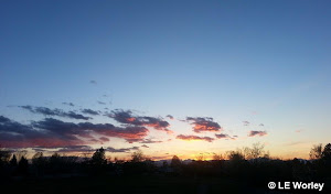
May can bring just about any type of weather to Colorado and amazing sunsets like this are quite common. (LE Worley)
The month of May can bring just about any type of weather to Thornton and Colorado. Snow is still possible although pleasant days sometimes interrupted by spring severe weather are more common. Our photo slideshow for the month captures the widely varying weather.
Slideshow updated May 26, 2014
Showcasing images captured by ThorntonWeather.com readers as well as some of our own, our monthly slideshow covers the entire gamut of weather-related imagery.
Sunsets, sunrises, wildlife and of course every type of weather condition are vividly depicted. May brings some very dynamic weather and the photos are a great way to see the stunning variety.
To learn more about how to send your photo to us for inclusion in the slideshow, see below the slideshow.
Click the play button below and sit back and enjoy the images.
What is missing in the slideshow above? Your photo!
Our monthly photo slideshow is going to feature images that we have taken but more importantly images that you have captured. The photos can be of anything even remotely weather-related.
Landscapes, current conditions, wildlife, pets, kids. Whimsical, newsy, artsy. Taken at the zoo, some other area attraction, a local park, a national park or your backyard. You name it, we want to see and share it!
Images can be taken in Thornton, Denver or anywhere across the extraordinary Centennial State. We’ll even take some from out of state if we can tie it to Colorado somehow.
We’ll keep the criteria very open to interpretation with just about any image eligible to be shown in our slideshows.
What do you win for having your image in our slideshow? We are just a ‘mom and pop’ outfit and make no money from our site so we really don’t have the means to provide prizes. However you will have our undying gratitude and the satisfaction that your images are shared on the most popular website in Thornton.
To share you images with us and get them included in the slideshow just email them to us or share them with ThorntonWeather.com on any of the various social media outlets. Links are provided below.
Severe weather is a common occurrence as we get further into spring and northeastern Colorado is set to experience multiple days of weather excitement. The first day’s activity skipped Thornton and stayed south but that is not expected to be the case Wednesday and Thursday.
Atmospheric conditions are primed for what may be a day of significant severe weather. Large, damaging hail, strong wind gusts, lightning and brief, heavy rain will all be likely. Some tornado activity will also be possible.
We will be monitoring monitoring the severe weather very closely and posting regularly to our Facebook page and Twitter feed. You can follow along in real time below. We are also on Google+ here.


 Extreme weather can occur during in month in Colorado we well know. June however is when traditional spring severe weather arrives in the state oftentimes with hail, damaging wind and tornadoes.
")


 Severe weather is a common occurrence as we get further into spring and northeastern Colorado is set to experience multiple days of weather excitement. The first day’s activity skipped Thornton and stayed south but that is not expected to be the case Wednesday and Thursday.