Weather Geek Stuff is a great place to shop for gifts for weather enthusiasts, weather geeks and weather lovers.
Not everyone gets excited about blizzards, tornadoes, hurricanes and other types of extreme weather but many folks out there are passionate about Mother Nature. Weather Geek Stuff is an online shop just for those whose hearts race with the thrill of severe weather and they are offering special deals through the holiday season.
Weather Geek Stuff is an online store that provides a host of clothing items and novelties just for weather buffs. From the store’s custom ‘Weather Geek’ and ‘Weather Diva’ logoed merchandise to items imprinted with amusing weather warnings signs as well as Skywarn storm spotter logos, there is something there sure to please any weather lover.
Weather Geek Stuff’s merchandise was shown on the Weather Channel as a recommended gift so you know the quality is good. Stu Ostro, Weather Channel’s Senior Director of Weather Communications even sports a ‘Weather Geek’ t-shirt on his Facebook page and Twitter profile.
Kids and dogs aren’t left out of the weather fun either. There is a wide variety of clothing items sized just right for the little ones from babies to bigger kids. Canine companions as well can get shirts and bowls emblazoned with a weather-related logo.
The selection goes far beyond clothing too. Water bottles, clocks, mugs, bags and other novelties are part of the store’s offerings. For the tech types, cases for iPhones and iPads are available. Recently added products include laptop skins, clipboards and throw blankets.
Weather Geek Stuff is owned and operated by the same folks that run ThorntonWeather.com. We provide ThorntonWeather.com as a no-cost service to the community and use the minimal amount of money made from Weather Geek Stuff to support the costs of running this website and the associated equipment. So remember, if you have a weather buff on your shopping list, by buying from Weather Geek Stuff you are supporting ThorntonWeather.com! You can also donate directly to fund the site here.
The holiday season is about to kick off with Thanksgiving and with many folks traveling in the coming weeks, the focus is oftentimes on the weather. Looking back at Denver’s historical Thanksgiving weather, we see that the day is usually dry with comfortable temperatures.
Details on every Thanksgiving in Denver since recordkeeping began in 1872 is below. While calm and dry may be the norm, that doesn’t mean that drama isn’t possible.
For this year, what can we expect? At this time it all depends on which forecast model you want to believe.
The GFS indicates a cold front with temperatures in the 30s. The ECMWF points to ridging which would lead to an unseasonably warm day. Which would we side with? For right now we prefer the ECMWF solution.
Stay up to date with Thornton’s weather: Be sure to ‘like’ us on Facebook, follow us on Twitter and add us to your Google+ circles.
From the National Weather Service – Thanksgiving climatology:
Yet another cold weather record fell this morning as the mercury dropped.
As measured at Denver International Airport, the low temperature this morning plunged to -14 degrees. This easily bested the record low temperature for November 13 of -3 degrees set in 1916.
Here in Thornton the mercury didn’t fall quite as far. Our morning low was -8.8 degrees.
Our bone-chilling blast of cold air continued its record-setting ways on Wednesday as two cold temperature records fell.
The official high temperature for the day only reached 6 degrees in Denver as measured at Denver International Airport. This easily bested the previous record low maximum for the date of 9 degrees set in 1916. Here in Thornton we were slightly warmer with a high of 8.4 degrees.
Additionally, clearing skies late in the day aided in sending the mercury plunging after dark leading to the second record.
Before midnight the temperature dropped to a miserable -13 degrees at DIA. This shattered the previous record low temperature for November 12 of -4 degrees set 132 years ago in 1882. Thornton managed to stay quite a bit warmer, dropping only to -4.7 degrees just before midnight.
The Mile High City will also be setting a record low temperature for November 13. The old record of -3 degrees was set in 1916. We will have to see how cold it gets in the early morning hours to see what the final number ends up being.
Stay up to date with Thornton’s weather: Be sure to ‘like’ us on Facebook, follow us on Twitter and add us to your Google+ circles.
New record low maximum temperature set in Denver today.
The high temperature in the Mile High City topped out at 16 degrees at 12:46pm today. This crushed the old record for the date of 19 degrees set 98 years ago in 1916. Here in Thornton we were only slightly warmer today with a high of 17 degrees.
Looking ahead, more records may fall in the next 48 hours or so.
Tomorrow’s record low max of 9 degrees, also set in 1916, could fall with current forecasts calling for a high of only 7 degrees. Also, with low temperatures tomorrow night forecast to drop to -5 degrees, we could set a record low temperature for November 13 (-3 degrees in 1916).
The weather during the month of November in Denver metro area can offer just about anything. While it is normally a quiet month, it can be prone to extremes.
November is Denver’s second snowiest month and major snowstorms are not entirely uncommon. However conditions can also be quite dry.
Temperatures during the month continue to cool as we get closer to winter and by the end of the month the low temperatures routinely dip to 20 degrees or below. At times it can in fact bring conditions more like what we see in January.
Generally pleasant, unseasonably warm temperatures were the highlight of October 2014 in Thornton. The month was also notable for its distinct lack of snow.
We started out the first few days of the month with cooler than normal conditions and a good shot of rain on the first. We rebounded quickly though as high pressure built and warmer weather returned including an 80 degree temperature reading on the 6th. Four out of five days between the 9th and 13th were cooler than normal but then warmer temperatures dominated through to the 26th of the month. The final days saw cooler conditions for the most part.
Overall, Thornton’s average temperature for the month was 52.7 degrees. This was a good ways above the Denver long term average for October of 50.9 degrees.
Out at the airport, Denver’s official average was even warmer at 55.2 degrees. This was close to making the top 10 list of warmest Octobers as number 10 is 55.4 degrees (1910).
Thornton’s warmest reading was 81 degrees on the 24th and its coldest was a chilly 27.1 degrees on the morning of the 28th. Denver saw its warmest reading of 83 degrees on the 15th and its coldest of 29 degrees on the 27th.
Denver set or tied four temperature records during the month. A new record high maximum was set for the 15th (83 degrees) and 24th (82 degrees). The record high for the 25th was tied (80 degrees) and the record high minimum for the 26th was tied (49 degrees).
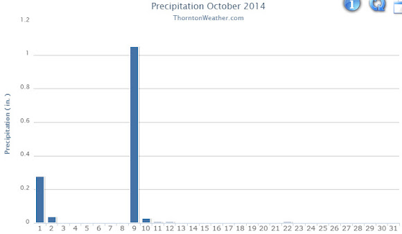
In terms of precipitation, Thornton saw above average rainfall in its bucket while Denver was below. In all, 1.43” fell in Thornton although the vast majority of that was on two days (the 1st and 9th). Denver International Airport recorded only 0.52 inches. Denver’s average for October is 1.02 inches.
Neither Thornton nor Denver recorded any snowfall during the month. On average the Mile High City sees 4.0 inches of the white stuff.
Thornton, Colorado October 2014 temperature summary.Thornton, Colorado October 2014 precipitation summary.
From the National Weather Service:
CLIMATE REPORT
NATIONAL WEATHER SERVICE BOULDER, CO
804 AM MDT SAT NOV 1 2014

...................................

...THE DENVER CO CLIMATE SUMMARY FOR THE MONTH OF OCTOBER 2014...

CLIMATE NORMAL PERIOD 1981 TO 2010
CLIMATE RECORD PERIOD 1872 TO 2014

WEATHER         OBSERVED          NORMAL  DEPART  LAST YEAR`S
                 VALUE   DATE(S)  VALUE   FROM    VALUE  DATE(S)
                                          NORMAL
................................................................
TEMPERATURE (F)
RECORD
 HIGH              90   10/01/1892
 LOW               -2   10/29/1917
HIGHEST            83   10/15        83       0       79  10/08
LOWEST             29   10/27        22       7       27  10/16
                                                          10/05
AVG. MAXIMUM     69.7              65.3     4.4     60.0
AVG. MINIMUM     40.7              36.6     4.1     35.5
MEAN             55.2              50.9     4.3     47.7
DAYS MAX >= 90      0               0.0     0.0        0
DAYS MAX <= 32      0               0.4    -0.4        0
DAYS MIN <= 32      4               8.5    -4.5       12
DAYS MIN <= 0       0               0.0     0.0        0
PRECIPITATION (INCHES)
RECORD
 MAXIMUM         4.17   1969
 MINIMUM            T   1934
TOTALS           0.52              1.02   -0.50     0.72
DAILY AVG.       0.02              0.03   -0.01     0.02
DAYS >= .01         5               5.3    -0.3        8
DAYS >= .10         2               2.4    -0.4        3
DAYS >= .50         0               0.5    -0.5        0
DAYS >= 1.00        0               0.1    -0.1        0
GREATEST
 24 HR. TOTAL    0.26   10/09 TO 10/10           10/18 TO 10/18

SNOWFALL (INCHES)
RECORDS
 TOTAL           31.2   1969
TOTALS            0.0               4.0

DEGREE_DAYS
HEATING TOTAL     296               440    -144      525
 SINCE 7/1        394               581    -187      608
COOLING TOTAL       0                 5      -5        0
 SINCE 1/1        701               769     -68      999

FREEZE DATES
RECORD
 EARLIEST     09/08/1962
 LATEST       06/08/2007
EARLIEST      10/03             10/07
LATEST                          05/05
.....................................................

WIND (MPH)
AVERAGE WIND SPEED              9.1
RESULTANT WIND SPEED/DIRECTION   3/197
HIGHEST WIND SPEED/DIRECTION    35/020    DATE  10/02
HIGHEST GUST SPEED/DIRECTION    44/010    DATE  10/02

SKY COVER
POSSIBLE SUNSHINE (PERCENT)   MM
AVERAGE SKY COVER           0.50
NUMBER OF DAYS FAIR           11
NUMBER OF DAYS PC             17
NUMBER OF DAYS CLOUDY          3

AVERAGE RH (PERCENT)     49

WEATHER CONDITIONS. NUMBER OF DAYS WITH
THUNDERSTORM              0     MIXED PRECIP               0
HEAVY RAIN                1     RAIN                       1
LIGHT RAIN                8     FREEZING RAIN              0
LT FREEZING RAIN          0     HAIL                       0
HEAVY SNOW                0     SNOW                       0
LIGHT SNOW                0     SLEET                      0
FOG                       4     FOG W/VIS <= 1/4 MILE      0
HAZE                      8

-  INDICATES NEGATIVE NUMBERS.
R  INDICATES RECORD WAS SET OR TIED.
MM INDICATES DATA IS MISSING.
T  INDICATES TRACE AMOUNT.

.....OCTOBER 2014 WARMER AND DRIER THAN AVERAGE.....

OCTOBER 2014 STARTED OUT COOLER THAN NORMAL AS AN UPPER LEVEL TROUGH
OF LOW PRESSURE MOVED ACROSS THE CENTRAL AND NORTHERN ROCKY MOUNTAIN
STATES. THIS SYSTEM BROUGHT SOME LIGHT RAIN TO DENVER ON THE FIRST.
WARMER TEMPERATURES MOVED INTO NORTH CENTRAL AND NORTHEASTERN
COLORADO BY THE 5TH AS UPPER LEVEL HIGH PRESSURE BUILT OVER THE
WESTERN UNITED STATES. COOLER TEMPERATURES AND PRECIPITATION MOVED
INTO THE FRONT RANGE OF COLORADO ON THE 9TH AS A WEAK UPPER LEVEL
TROUGH AND ASSOCIATED COLD FRONT MOVED ACROSS THE REGION. UPPER
LEVEL HIGH PRESSURE REBUILT OVER THE REGION ON THE 14TH...WITH A 13
DAY STRETCH OF ABOVE NORMAL TEMPERATURES AT DENVER INTERNATIONAL
AIRPORT FROM THE 14TH THROUGH THE 26TH. THE TEMPERATURE REACHED OR
EXCEEDED THE 80 DEGREE MARK ON ON THE 15TH, 24TH AND 25TH. ANOTHER
UPPER LEVEL STORM SYSTEM AND COLD FRONT BROUGHT COOLER TEMPERATURES
TO NORTHEASTERN COLORADO ON THE 27TH AND 28TH...WITH TEMPERATURES
RETURNING TO SLIGHTLY ABOVE NORMAL VALUES THE LAST FEW DAYS OF THE
MONTH.

TEMPERATURES:

THE AVERAGE TEMPERATURE AT DENVER INTERNATIONAL AIRPORT FOR THE
MONTH OF OCTOBER WAS 55.2 DEGREES F WHICH WAS 4.3 DEGREES ABOVE
NORMAL. OCTOBER OF 1950 WAS THE WARMEST OCTOBER ON RECORD...WITH AN
AVERAGE TEMPERATURE OF 59.9 DEGREES F.  THE COLDEST OCTOBER ON
RECORD WAS 39.0 DEGREES F BACK IN 1969. THERE WERE NO DAYS IN WHICH
THE MAXIMUM TEMPERATURE EXCEEDED 90 DEGREES. THE HIGHEST TEMPERATURE
OF THE MONTH WAS 83 DEGREES WHICH OCCURRED ON THE 15TH. THE COLDEST
TEMPERATURE OF THE MONTH WAS 29 DEGREES OCCURRED ON THE MORNING OF
THE 27TH.

DAILY RECORDS:

DATE      TEMPERATURE    TYPE OF RECORD    OLD RECORD   YEAR LAST SET

OCT 15TH  83 DEGREES     RECORD HIGH MAX   82 DEGREES       2011
OCT 24TH  82 DEGREES     RECORD HIGH MAX   80 DEGREES       2011
OCT 25TH  80 DEGREES     TIED HIGH MAX     80 DEGREES       2007
OCT 26TH  49 DEGREES     TIED HIGH MIN     49 DEGREES       1927

PRECIPITATION:

PRECIPITATION FOR THE MONTH OF OCTOBER AT DENVER INTERNATIONAL
AIRPORT WAS 0.52 INCHES...WHICH IS 0.50 INCHES BELOW THE NORMAL OF
1.02 INCHES. THERE WERE 4 DAYS WITH MEASURABLE PRECIPITATION. ON THE
9TH...0.25 INCHES OF PRECIPITATION FELL WHICH IS THE GREATEST DAILY
AMOUNT FOR THE MONTH.

TEN WETTEST OCTOBER`S IN DENVER WEATHER HISTORY SINCE 1872:

4.17 INCHES 1969
3.92 INCHES 1892
3.72 INCHES 1942
3.50 INCHES 1923
3.47 INCHES 1984
3.05 INCHES 1914
3.03 INCHES 2007
2.84 INCHES 1947
2.62 INCHES 1957
2.46 INCHES 1959, 1960

TEN DRIEST OCTOBER`S IN DENVER WEATHER HISTORY SINCE 1872:

 T   INCHES 1934
0.01 INCHES 1933
0.05 INCHES 1944, 1962
0.06 INCHES 1948, 1954, 1988
0.08 INCHES 2001, 2003
0.10 INCHES 1980
0.12 INCHES 1876, 1938, 1950
0.17 INCHES 1907
0.18 INCHES 1952, 1964
0.19 INCHES 1879, 1894, 1927

TEN SNOWIEST OCTOBER`S IN DENVER WEATHER HISTORY SINCE 1872:

31.2 INCHES 1969
22.7 INCHES 1906
22.1 INCHES 1997
17.8 INCHES 1923
17.2 INCHES 2009
16.4 INCHES 1897
16.2 INCHES 1929
14.0 INCHES 1889
13.8 INCHES 1905
13.6 INCHES 1908

THERE WERE 3 DAYS IN WHICH THUNDER WAS OBSERVED AT DENVER
INTERNATIONAL AIRPORT...NO DAYS WITH HAIL AND NO DAYS WITH DENSE FOG
WITH A VISIBILITY AT OR BELOW 1/4 MILE DURING THE MONTH. A PEAK WIND
OF 44 MPH FROM A NORTHERLY DIRECTION WAS RECORDED ON THE 2ND.
The United States returns to Standard Time at 2:00am Sunday as Daylight Saving Time comes to an end.
The biannual ritual of changing our clocks to adjust for Daylight Saving Time occurs tonight providing yet another signal of the changing of seasons. The United States will ‘fall back’ one hour at 2:00am Sunday morning as we return to Standard Time.
The ritual of changing our clocks twice a year can be met with some resistance as some people struggle to adjust their body’s internal clock. Others actually like the return to standard time as they get to enjoy an extra hour of sleep.
The time change definitely has big effects on the dawning of daylight and how early it gets dark in the evening.
Sunrise on Saturday occurs at 7:28am but on Sunday it will be at 6:30am. Similarly, sunset will occur at 5:57pm on Saturday but on Sunday the sun will disappear over the horizon at 4:53pm.
For many this means that when they get home from work it will now be dark and outdoor activities will be significantly curtailed as a result.
Arizona and Hawaii are the only states that do not observe Daylight Saving Time and remain on Standard Time year round. The U.S. territories of Puerto Rico, American Samoa, Guam, Northern Mariana Islands, and the United States Virgin Islands also do not observe the event.
It won’t be all that long though before Daylight Saving Time returns. On March 8, 2015 we will ‘spring forward.’
Daylight Saving Time Schedule
The mandated beginning and end of Daylight Saving Time has changed in the United States over the years.
The most recent schedule was set by the Energy Policy Act of 2005 and took effect in 2007. We now ‘spring forward’ to begin Daylight Saving Time on the second Sunday in March and ‘fall back’ with the return to Standard Time on the first Sunday in November.
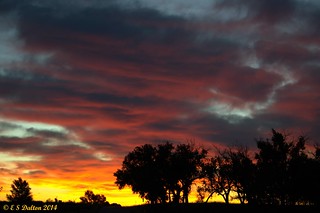
October 1, 2014 – Sunrise at the Rocky Mountain Arsenal. (Ed Dalton)
October in Thornton can bring a wide variety of weather conditions, perfect for the photographer in all of us.
The month brings the changing of the colors at Colorado’s lower elevations and it is also is typically when we see our first freeze and first snow. Couple those facts with our usual widely varying landscapes and wildlife and we have a month that is sure to bring in plenty of photo opportunities.
Slideshow updated October 31, 2014
To learn more about how to send your photo to us for inclusion in the slideshow, see below the slideshow.
Showcasing images captured by ThorntonWeather.com readers as well as some of our own, our monthly slideshow covers the entire gamut of weather-related imagery.
Sunsets, sunrises, wildlife and of course every type of weather condition are vividly depicted in images captured from yours and our cameras.
[flickr_set id=”72157648031120697″]
What is missing in the slideshow above? Your photo!
Our monthly photo slideshow is going to feature images that we have taken but more importantly images that you have captured. The photos can be of anything even remotely weather-related.
Landscapes, current conditions, wildlife, pets, kids. Whimsical, newsy, artsy. Taken at the zoo, some other area attraction, a local park, a national park or your backyard. You name it, we want to see and share it!
Images can be taken in Thornton, Denver or anywhere across the extraordinary Centennial State. We’ll even take some from out of state if we can tie it to Colorado somehow.
We’ll keep the criteria very open to interpretation with just about any image eligible to be shown in our slideshows.
What do you win for having your image in our slideshow? We are just a ‘mom and pop’ outfit and make no money from our site so we really don’t have the means to provide prizes. However you will have our undying gratitude and the satisfaction that your images are shared on the most popular website in Thornton.
To share you images with us and get them included in the slideshow just email them to us or share them with ThorntonWeather.com on any of the various social media outlets. Links are provided below.
The unseasonably warm weather of the past week will begin coming to an end soon. Slightly cooler weather is on tap tomorrow and then with a cold front moving in Sunday night, temperatures close to normal are expected for much of the week.
Stay up to date with Thornton’s weather: Be sure to ‘like’ us on Facebook, follow us on Twitter and add us to your Google+ circles.
Weather, natural disasters & climate news and information.


 The holiday season is about to kick off with Thanksgiving and with many folks traveling in the coming weeks, the focus is oftentimes on the weather. Looking back at Denver’s historical Thanksgiving weather, we see that the day is usually dry with comfortable temperatures.
 Yet another cold weather record fell this morning as the mercury dropped.
 The weather during the month of November in Denver metro area can offer just about anything. While it is normally a quiet month, it can be prone to extremes.
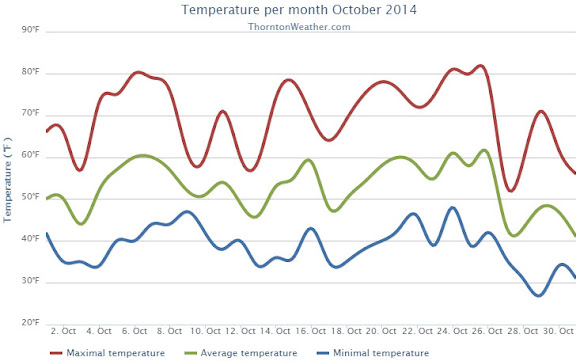
 With a record-tying high temperature reading today, Denver recorded its third high temperature record of October 2014.