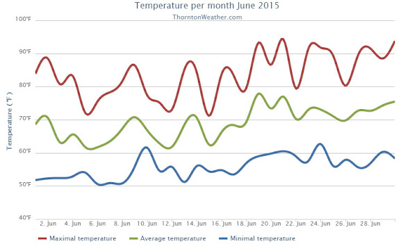
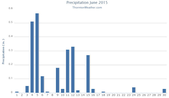
March 2015 weather recap: Dry conditions, warm temperatures month’s biggest feature

The month of March was relatively uneventful and lacked any sort of real weather drama.  What was notable was the dry conditions and unseasonably warm temperatures that dominated for the most part.

March started out considerably colder than normal with the first five days of the month seeing temperatures around 20 degrees below normal.  A light shot of snow was recorded on the fourth of the month, a reading that would be our biggest snowfall for the period.

Temperatures began to turn warmer on the sixth with above normal readings recorded through the 16th of the month.  We even managed two 80+ degree days on the 15th and 16th.

Denver actually saw its earliest 80 degree reading in history on the 16th.  The previous earliest 80 degree reading occurred on March 18, 1907.

Unsettled conditions interrupted the warmth on the 25th with a light snowfall and colder temperatures.

We then bounced right back to the dry, mild conditions for the balance of the month.

Thornton’s average temperature for the month came in at 44.9 degrees.  This was well above the long term Denver average of 40.4 degrees.  Out at DIA, the Mile High City’s reading was very similar at 45.0 degrees.

Temperatures in Thornton ranged from a high of 82.6 degrees on the 16th down to a low of 9.2 degrees on the 5th of the month.  At the airport, Denver’s maximum for the month of 81 degrees came on the 16th with its lowest of 2 degrees on the 5th.

Denver officially broke two temperature records in March 2015.  On March 6th the high temperature of 79 degrees broke the record high for the date (previously 76 degrees set in 2013).  Also, on the 16th, the high temperature reading of 81 degrees was a record (previously 75 degrees in 2012).

In terms of precipitation, the rain bucket totals fell well short of the March average of 0.92 inch.  Here in Thornton a mere 0.49 inches was recorded while Denver saw quite a bit more with a measurement of 0.79 inches.

March is historically our snowiest month but that was certainly not the case in 2015.  Thornton snowfall totally only 2.8 inches and Denver was at 2.9 inches. Both were well below the average of 10.7 inches.

Click here to view Thornton’s March 2015 climate report.

Thornton, Colorado March 2015 Temperature Summary. (ThorntonWeather.com)
Thornton, Colorado March 2015 Precipitation Summary. (ThorntonWeather.com)
CLIMATE REPORT
NATIONAL WEATHER SERVICE BOULDER, CO
633 AM MDT WED APR 1 2015

...................................

...THE DENVER CO CLIMATE SUMMARY FOR THE MONTH OF MARCH 2015...

CLIMATE NORMAL PERIOD 1981 TO 2010
CLIMATE RECORD PERIOD 1872 TO 2015

WEATHER         OBSERVED          NORMAL  DEPART   LAST YEAR`S
                 VALUE   DATE(S)  VALUE   FROM    VALUE  DATE(S)
                                          NORMAL
................................................................
TEMPERATURE (F)
RECORD
 HIGH              84   03/26/1971
 LOW              -11   03/28/1886
HIGHEST            81   03/16/2015                    73  03/09
LOWEST              2   03/05/2015                     4  03/02
AVG. MAXIMUM     58.9              54.4     4.5     55.8
AVG. MINIMUM     31.2              26.4     4.8     25.9
MEAN             45.0              40.4     4.6     40.9
DAYS MAX >= 90      0               0.0     0.0        0
DAYS MAX <= 32      2               1.9     0.1        2
DAYS MIN <= 32     12              23.6   -11.6       23
DAYS MIN <= 0       0               0.1    -0.1        0 
PRECIPITATION (INCHES)
 RECORD
  MAXIMUM         4.56   1983
  MINIMUM         0.03   2012 
TOTALS           0.79              0.92   -0.13     0.83 
DAILY AVG.       0.03              0.03    0.00     0.03 
DAYS >= .01         5               5.9    -0.9        9
DAYS >= .10         3               2.4     0.6        2
DAYS >= .50         0               0.3    -0.3        0
DAYS >= 1.00        0               0.1    -0.1        0
GREATEST
 24 HR. TOTAL    0.34   03/19 TO 03/19

SNOWFALL (INCHES)
TOTALS            2.9              10.7

DEGREE_DAYS
HEATING TOTAL     611               763    -152      739
 SINCE 7/1       4724              5202    -478     5258
COOLING TOTAL       0                 0       0        0
 SINCE 1/1          0                 0       0        0

FREEZE DATES
RECORD
 EARLIEST     09/08/1962
 LATEST       06/08/2007
EARLIEST                        10/07
LATEST                          05/05
........................................................

WIND (MPH)
AVERAGE WIND SPEED              9.9
RESULTANT WIND SPEED/DIRECTION   3/198
HIGHEST WIND SPEED/DIRECTION    36/260    DATE  03/23
HIGHEST GUST SPEED/DIRECTION    45/260    DATE  03/23

SKY COVER
AVERAGE SKY COVER           0.50
NUMBER OF DAYS FAIR           12
NUMBER OF DAYS PC             12
NUMBER OF DAYS CLOUDY          7

AVERAGE RH (PERCENT)     51

WEATHER CONDITIONS. NUMBER OF DAYS WITH
THUNDERSTORM              0     MIXED PRECIP               0
HEAVY RAIN                0     RAIN                       1
LIGHT RAIN                5     FREEZING RAIN              0
LT FREEZING RAIN          0     HAIL                       0
HEAVY SNOW                0     SNOW                       4
LIGHT SNOW                3     SLEET                      0
FOG                       7     FOG W/VIS <= 1/4 MILE      4
HAZE                      4

-  INDICATES NEGATIVE NUMBERS.
R  INDICATES RECORD WAS SET OR TIED.
MM INDICATES DATA IS MISSING.
T  INDICATES TRACE AMOUNT.

April 5 to April 11: This week in Denver weather history

This Week In Denver Weather History
April 5 to April 11: This week in Denver weather history

An incredibly busy week on the Denver weather history calendar as we see below.  Thunderstorms, blizzards, tornadoes, hurricane force winds and more have all been seen during this week in Denver weather history.

From the National Weather Service:

2-5

In 1918…snowfall totaled 12.4 inches over downtown Denver. Most of the snow fell on the 3rd and 4th. Temperatures were in the 20`s and 30`s. Northwest winds were sustained to 24 mph on the 2nd.

3-5

In 1996…the foothills west of Denver received 6 to 8 inches of new snow. Only 0.8 inch of snow fell at the site of the former Stapleton International Airport…along with some freezing drizzle on the 4th and 5th. North-northeast winds gusted to 30 mph at Denver International Airport on the 3rd.

3-6

In 1898…snowfall totaled 8.7 inches in downtown Denver over the 4 days. Northeast winds were sustained to 48 mph with gusts as high as 60 mph on the 3rd.

In 1983…a prolonged heavy snow storm blanketed the area along with very cold temperatures. The greatest amounts of snow fell in the foothills where 24 to 42 inches were measured. A foot of snow fell in Boulder. Snow fell for 50 consecutive hours at Stapleton International Airport on the 3rd through the 5th with a total snowfall of 8.8 inches and a maximum accumulation on the ground of 6 inches on the 5th. In Denver…the mercury failed to rise above freezing for 3 consecutive days…on the 4th…5th… And 6th…for the first time ever in April. Five daily temperature records were set from the 4th through the 6th. Record low temperatures of 12 degrees occurred on the 5th with 7 degrees on the 6th. Record low maximum temperatures of 25 degrees occurred on the 4th…27 degrees on the 5th… And 28 degrees on the 6th.

4-5

In 1900…rain changed to heavy snow and totaled 7.8 inches in downtown Denver overnight. A thunderstorm on the 4th produced hail. Precipitation totaled 1.50 inches.

In 1911…north to northwest winds were sustained to 42 mph on the 4th and to 41 mph on the 5th.

In 2002…a whitish-colored haze engulfed metro Denver on both days. The haze was the result of a huge wind storm that kicked up dust and sand from the Gobi desert in Mongolia and China during the latter half of March. Westerly winds aloft transported the dust cloud across the Pacific Ocean and over the western united states…depositing some of it on Colorado.

In 2009…a blizzard developed over the northeast plains of Colorado. Most of the urban corridor was spared from the blizzard…with the exception of eastern Adams and eastern Arapahoe counties. The combination of strong wind and heavy snow snapped 14 power lines along State Highway 36… Near Strasburg. In Arapahoe County…7 poles were snapped in Bennett. Interstate 70 was closed in both directions east of Denver. At Denver International Airport…a peak wind gust of 63 mph was observed from the north…breaking the previous record of 62 mph established in 1986. Officially…only 0.3 inches of snowfall was measured at Denver International Airport.

4-7

In 1909…post-frontal rain changed to heavy snow on the afternoon of the 4th and continued through mid-morning of the 7th. Total snowfall was 18.7 inches…but most of the snow…14.0 inches… Fell from 6:00 pm on the 4th to 6:00 pm on the 5th. North to northeast winds were sustained to 32 mph on the 4th and to 30 mph on the 7th. Total precipitation from the storm was 1.78 inches.

5

In 1873…a heavy rain and hail shower in the afternoon changed to snow…and accumulated to 6 inches on the streets at 9:00 pm. Precipitation (rain and melted snow) totaled 0.56 inch.

In 1925…southeast winds were sustained to 46 mph with gusts to 50 mph. This was the strongest wind of the month that year.

In 1950…a well-developed dust devil was observed 4 to 5 miles south-southwest of Stapleton Airport for about 8 minutes.

In 1977…the earliest date of the last freeze of the season occurred when the temperature dipped to a low of 31 degrees.

In 1988…a wind gust to 74 mph was recorded at Rollinsville. West winds gusted to 35 mph at Stapleton International Airport.

In 1990…a heavy… Wet snow fell in many areas in and along the Colorado Front Range. Snowfall amounts of 4 to 7 inches were common around the Boulder area with lesser amounts elsewhere. Only 2.0 inches of snow fell at Stapleton International Airport where north winds gusted to 28 mph. Icy roads contributed to numerous fender-benders and a 20-vehicle pileup near the junction of I-70 and I-25 in the city.

In 2000…high winds developed in the Front Range foothills… From about I-70 northWard. Peak wind gusts included: 83 mph at the National Center for Atmospheric Research in Boulder…75 mph near Louisville… And 70 mph at the National Wind Technology Center…south of Boulder. West winds gusted to 41 mph at Denver International Airport.

In 2005…a surface low pressure center deepened over eastern Colorado and produced damaging high winds across metro Denver. The strong wind gusts ranging from 50 to 70 mph damaged roofs and fences. Cross-winds blew several empty semI-trailers on their sides along I-70 and I-76 east of Denver. Peak north wind gusts included: 60 mph near Bennett and Keenesburg…59 mph near Brighton… And 53 mph at Denver International Airport. Over the Palmer Divide south of Denver…the high winds combined with heavy snow to produce blizzard conditions. Snowfall accumulations ranged from 3 to 8 inches over eastern Douglas and western Elbert counties. Snowfall totals included: 8 inches at Sedalia…4 inches near Castle Rock… And 3.5 inches near Franktown.

5-6

In 1939…3.0 inches of snow fell in downtown Denver. North winds were sustained to 34 mph on the 5th and to 26 mph on the 6th. The strong winds caused considerable drifting of snow. Several highways leading into the city were closed during the height of the storm due to poor visibility. Streets and highways became coated with ice in places. The temperature dipped to 11 degrees early on the 6th. This was the coldest reading of the month that year. Most vegetation was not far enough advanced to be injured by the cold temperatures…although a few buds froze on early shrubbery.

In 1949…strong winds in Boulder caused limited minor damage. West-northwest winds were sustained to 24 mph with some higher gusts at Stapleton Airport.

5-7

In 1916…rain changed to snow behind a cold front on the 5th and totaled 4.5 inches in the city. A thunderstorm produced snow on the 6th. North winds were sustained to 35 mph with gusts to 38 mph on the 7th.

6

In 1904…northwest winds were sustained to 40 mph with gusts to 48 mph.

In 1919…post-frontal rain changed to snow but totaled only 0.1 inch. However…north winds were sustained to 40 mph with gusts to 44 mph in the city.

In 1954…a vigorous cold front produced northeast winds at 38 mph with gusts as high as 50 mph. The strong winds briefly reduced visibility to 1 1/2 miles in blowing dust at Stapleton Airport.

In 1972…wind gusts to 68 mph were recorded at the National Bureau of Standards in Boulder. Winds peaked to 54 mph in downtown Boulder. Minor damage was reported. Northwest winds gusted to 44 mph at Stapleton International Airport where the strong Chinook winds warmed the temperature to a high of 80 degrees…equaling the record maximum for the date.

Continue reading April 5 to April 11: This week in Denver weather history

March 29 to April 4: This week in Denver weather history

This Week In Denver Weather History
March 29 to April 4: This week in Denver weather history

This week in Denver weather history is notable for the variety of conditions that can be experienced this time of year.  From hurricane force winds and heavy snow to more typical spring severe weather like tornadoes, all can be experienced this time of year.

From the National Weather Service:

27-29

In 1948…high winds raked Boulder. A wind gust to 75 mph was recorded at Valmont. Sustained winds in excess of 35 mph were estimated in Boulder. Minor damage was reported.

In 1961…heavy snowfall totaled 9.5 inches at Stapleton Airport over the 3 day period. Most of the snow…5.3 inches…fell on the 28th. Winds were generally light and gusted to only 22 mph from the north.

28-29

In 1891…rain changed to snow and totaled 9.7 inches in the city. Northeast winds were sustained to 12 mph with gusts to 28 mph on the 28th.

In 1910…a strong cold front brought much wind…rain…and and snow to the city. Rain on the 28th changed to snow early on the 29th. Snowfall totaled only 2.8 inches…but north winds were sustained to 50 mph on the 29th. Precipitation from the storm totaled 0.96 inch.

In 1994…moist upslope winds combined with an upper level system to dump 5 to 7 inches of snow along the eastern foothills and across metro Denver. Snowfall totaled 6.3 inches at Stapleton International Airport where northeast winds gusted to 39 mph. Thirteen inches of new snow were measured at the Eldora ski area west of Boulder.

28-30

In 1949…a major winter storm dumped 11.3 inches of snow over downtown Denver. Snowfall totaled 10.4 inches at Stapleton Airport. North to northeast winds were sustained to 17 mph.

In 1985…a slow moving snow storm moved across the state. Denver received only 4.0 inches of snowfall with amounts in the foothills totaling 1 to 2 feet. Still…this was enough snow in Denver to cause flight delays of up to 6 hours at Stapleton International Airport on the night of the 29th. East winds gusted to 28 mph on the 28th.

29

In 1887…west winds sustained to 44 mph warmed the temperature to a high of 62 degrees.

In 1921…post-frontal northeast winds were sustained to 46 mph with gusts to 52 mph.

In 1925…southeast winds were sustained to 46 mph with gusts to 48 mph. These were the strongest winds of the month that year. The winds warmed the temperature to a high of 72 degrees.

In 1934…a construction worker was killed by lightning as he walked with a shovel on his shoulder along Cherry Creek in the city. The thunderstorm produced light rain.

In 1967…a southwest wind gust to 52 mph was recorded at Stapleton International Airport. The warm Chinook winds warmed the temperature to 79 degrees equaling the record for the date.

In 1979…a tornado touched down 4 miles southwest of Parker… But caused no reported damage.

In 1998…four children attending a birthday party in Denver were injured when an apparent dry microburst produced a sudden strong wind gust which blew an inflatable playhouse they were occupying into a neighbor’s yard. The playhouse scraped the roof of the host’s two-story house…then landed in the adjoining yard. The children were treated for minor head injuries and cuts.

29-30

In 1938…overnight heavy snowfall was 6.3 inches over downtown Denver.

In 1982…strong winds buffeted metro Denver…breaking windows and damaging roofs. Wind gusts to 90 mph were recorded in Boulder and 51 mph at Stapleton Airport. The strong winds flattened a condominium under construction in Lakewood.

In 1991…1 to 6 inches of snow fell across metro Denver with the heaviest snow confined to the foothills. Six inches of snow was recorded at South Platte in the foothills southwest of Denver and 3 inches at Castle Rock. Snowfall totaled only 0.7 inch at Stapleton International Airport where northeast winds gusted to 33 mph on the 29th.

29-31

In 1970…snowfall totaled 6.0 inches at Stapleton International Airport. Heavy snow accumulation in Boulder on the 29th caused the collapse of a carport at an apartment building…damaging 11 automobiles. Northeast winds gusted to 24 mph at Stapleton International Airport.

30

In 1895…rain changed to sleet…then snow…and totaled 8.0 inches in downtown Denver. Strong post-frontal northeast winds were sustained to 48 mph with gusts to 61 mph. Temperatures hovered around 30 degrees all day.

In 1968…microburst winds associated with virga and brief light rain gusted to 46 mph at Stapleton International Airport.

In 1983…winds gusted to 82 mph at the National Center for Atmospheric Research in Boulder with peak gusts of 70 to 80 mph in the foothills. Minor damage occurred at a construction site and to some homes in Boulder. West winds gusted to 39 mph at Stapleton International Airport.

30-31

In 1896…heavy snowfall totaled 7.5 inches in downtown Denver. Northwest winds gusted to 26 mph.

In 1897…rain changed to snow during the early morning of the 30th and totaled 6.2 inches before ending during the late morning of the 31st. Northwest winds were sustained to 35 mph with gusts to 46 mph.

In 1929…heavy snowfall of 7.0 inches was recorded over downtown Denver. Northwest winds were sustained to 23 mph on the 30th.

In 1953…heavy snowfall totaled 8.6 inches at Stapleton Airport where northeast winds gusted to 23 mph.

In 1955…a vigorous cold front produced north winds at 40 mph with gusts as high as 54 mph at Stapleton Airport. Rain and snow showers and blowing dust accompanied the front. Snowfall totaled only 0.1 inch at Stapleton Airport on the 31st.

In 1988…snow began falling on the afternoon of the 30th and continued through the 31st…burying metro Denver. Twelve to 18 inches of snow fell in the foothills to the west of Denver and Boulder with 6 to 12 inches across the rest of metro Denver. The storm disrupted aircraft operations at Stapleton International Airport where snowfall totaled 7.1 inches and north winds gusting to 32 mph reduced the visibility to less than 1/4 mile at times…causing air traffic delays of 2 to 3 hours.

In 2000…heavy snow once again developed over the foothills and the higher terrain to the south of metro Denver. Snowfall totals from the storm included: 16 inches atop Squaw Mountain…15 inches near Rollinsville…13 inches near Evergreen…12 inches near Morrison…11 inches in Coal Creek Canyon…10 inches near Blackhawk and in Eldorado Springs…9 inches at Ken Caryl Ranch and larkspur… And 8 inches near Elizabeth. Snowfall totaled only 4.1 inches at the site of the former Stapleton International Airport. North winds gusted to 32 mph at Denver International Airport on the 30th.

In 2005…a strong spring storm intensified over the eastern plains of Colorado and produced near-blizzard conditions to the east and southeast of Denver overnight. North to northwest winds from 20 to 35 mph with gusts to 50 mph produced extensive blowing snow and caused near zero visibilities at times and snow drifts from 2 to 4 feet in depth. Snowfall amounts included: 12 inches near Bennett…8 inches around Castle Rock… 7 inches near Sedalia…and 6 inches near Parker. Only 0.3 inch of snow was reported at Denver Stapleton. At Denver International Airport…north winds gusted to 37 mph on the 30th and 36 mph on the 31st.

In 2014…on the evening of the 30th…high based showers and thunderstorms produced microburst winds over northern Jefferson…eastern Boulder and southwest weld counties. Peak wind reports included: 77 mph at white ranch open space; 72 mph…2 miles north of Longmont; 67 mph near Erie and firestone; 60 mph near mead and 59 mph…5 miles northwest of Henderson; with 53 mph at Denver International Airport. The wind downed power lines in Weld County which sparked a small fire. High winds then developed in the Front Range foothills and urban corridor through the morning of the 31st. Peak wind gusts included: 98 mph near gold hill; 77 mph near Eldorado Springs; 61 mph at Centennial Airport; 59 mph at Buckley Air Force Base; with 44 mph at Denver International Airport.

Continue reading March 29 to April 4: This week in Denver weather history

March 2015 top shots: Monthly photo slideshow

Snow covers a Thornton yard early in the month of March. (LE Worley)

The month of March is the start of meteorological spring and while conditions do begin warming, winter weather is certainly out of the question.  From hot to cold, snow to rain, the conditions can be very conducive to great pictures as we see in our slideshow.

March in Denver typically means frequent and rapid weather changes. The days grow longer and we start enjoying more sunshine and sometimes summer-like weather. However, on occasion arctic air masses can still force their way south into Colorado dropping temperatures quickly and markedly.

With the active wildlife, increased outdoor activities by us humans, and of course the weather, March imagery contains a wide variety of subjects and extremes.

  • Slideshow updated March 29, 2015. To learn more about how to send your photo to us for inclusion in the slideshow, see below the slideshow.

Showcasing images captured by ThorntonWeather.com readers as well as some of our own, our monthly slideshow covers the entire gamut of weather-related imagery.

Sunsets, sunrises, wildlife and of course every type of weather condition are vividly depicted in images captured from yours and our cameras.

[flickr_set id=”72157651267455221″]

What is missing in the slideshow above?  Your photo!

Our monthly photo slideshow is going to feature images that we have taken but more importantly images that you have captured.  The photos can be of anything even remotely weather-related.

Landscapes, current conditions, wildlife, pets, kids.  Whimsical, newsy, artsy.  Taken at the zoo, some other area attraction, a local park, a national park or your backyard.  You name it, we want to see and share it!

Images can be taken in Thornton, Denver or anywhere across the extraordinary Centennial State.  We’ll even take some from out of state if we can tie it to Colorado somehow.

We’ll keep the criteria very open to interpretation with just about any image eligible to be shown in our slideshows.

What do you win for having your image in our slideshow?  We are just a ‘mom and pop’ outfit and make no money from our site so we really don’t have the means to provide prizes.  However you will have our undying gratitude and the satisfaction that your images are shared on the most popular website in Thornton.

To share you images with us and get them included in the slideshow just email them to us or share them with ThorntonWeather.com on any of the various social media outlets.  Links are provided below.

So come on, get those camera’s rolling!

March 22 to March 28: This week in Denver weather history

This Week In Denver Weather History
March 22 to March 28: This week in Denver weather history

This week in Denver weather history are a number of interesting events.  As March comes to a close we are not yet done with winter so snow is certainly still possible but we also start seeing more Spring-like weather.  Reminders of this include the coldest temperature ever recorded in March – 11 degrees below zero 123 years ago.  Conversely, 38 years ago the highest temperature ever recorded in March of 84 degrees was recorded.

From the National Weather Service:

20-22

In 1944…heavy snow fell over metro Denver for a total of 36 hours. The storm dumped 18.5 inches of snowfall over downtown Denver and 12.2 inches at Stapleton Airport. Fortunately…there were no strong winds with the storm. North winds to only 19 mph were recorded on the 21st.

21-22

In 1955…wind gusts to 98 mph were recorded at Rocky Flats south of Boulder. Some damage and a few minor injuries were reported in Boulder. Northwest winds were sustained to 28 mph with gusts to 39 mph at Stapleton Airport on the 22nd.

In 1966…a vigorous cold front produced only 1.7 inches of snowfall at Stapleton International Airport…but northeast winds gusted to 49 mph on the 21st. Temperatures cooled from a maximum of 66 degrees on the 21st to a minimum of 14 degrees on the 22nd. Strong winds occurred on both days.

In 1992…an arctic cold front produced upslope snow across metro Denver mainly west of I-25. Castle Rock reported 6 inches of snow with 3 inches at Evergreen. At Stapleton International Airport…only 1.5 inches of snowfall were measured and northeast winds gusted to 18 mph on the 21st.

22

In 1905…apparent post-frontal north winds were sustained to 49 mph.

In 1922…a vigorous cold front with north winds sustained to 41 mph brought only 0.6 inch of snowfall to the city. These were the highest winds of the month.

In 1966…high winds caused extensive blowing snow that impeded traffic and closed highways over a wide area of eastern Colorado. Wind damage was widespread…but minor. North wind gusts to 47 mph were recorded at Stapleton International Airport where visibility was reduced as low as 1/8 mile in blowing snow.

In 1975…a strong west wind gust to 51 mph was recorded at Stapleton International Airport…while east of Denver the strong winds caused minor property damage and considerable blowing dust which closed several roads.

In 1979…near-blizzard conditions paralyzed the northeastern quarter of the state. Strong winds and drifting snow closed many roads…including I-25 and I-70. Power outages darkened sections of metro Denver. Snow accumulations of 4 to 12 inches were measured over the plains with drifts several feet deep. Only 3.5 inches of snow were recorded at Stapleton International Airport where northeast winds gusted to 39 mph causing some blowing snow.

In 1995…strong winds associated with a fast moving pacific cold front moved from the mountains into metro Denver. Winds estimated at 60 to 75 mph picked up rocks and shattered the windows of a car in Louisville. The strong winds blew down and partially destroyed two houses under construction just north of Thornton. West winds gusted to 53 mph at Denver International Airport where the visibility was briefly reduced to 1/2 mile in blowing dust.

22-23

In 1936…heavy snowfall of 7.7 inches was measured in downtown Denver. The heavy wet snowfall formed a thick coating of snow on trees and shrubs…but caused little damage. North winds were sustained to 15 mph.

In 1984…around a half foot of new snow fell across metro Denver…causing flight delays at Stapleton International Airport where snowfall totaled 6.0 inches and north winds gusted to 31 mph. Up to a foot of snow fell in the foothills. Icy roads produced numerous traffic accidents.

In 2011…strong bora winds developed along the Front Range following the passage of a storm system. Peak wind gusts included: 87 mph at the National Wind Technology Center; 82 mph…6 miles northwest of Boulder; 72 mph at Front Range airport in Broomfield; 71 mph at Longmont; and 64 mph…4 miles west of Lakewood. At Denver International Airport…a peak wind gust of 48 mph from the west was observed on the 22nd.

In 2013…a wet early spring snowstorm brought heavy snow to parts of the Front Range foothills and urban corridor. The heaviest snowfall occurred near the Front Range foothills and palmer divide. Near blizzard conditions forced the closure of interstate 70 east of Denver. In the foothills… Storm totals included: 14.5 inches near Conifer; 14 inches just southwest of Eldorado Springs and Intercanyon; 13 inches near Indian Hills; 12.5 inches near Pinecliffe; 11.5 inches near Golden; 11 inches near Jamestown and Roxborough; 10.5 inches near Brookvale and 10 inches at Genesee. Across the urban corridor and Palmer Divide… Storm totals included: 12.5 inches…8 miles southeast of Watkins; 10.5 inches in Boulder…Centennial and Northglenn; 9.5 inches…just south of Aurora; 9 inches in Westminster; 8 inches at Lafayette; 7.5 inches near Morrison; 7 inches in Arvada…Bennett…Brighton; 6 inches in Highlands Ranch… Longmont…Louisville and Thornton. Officially…11.6 inches of snow fell at DIA from the evening of the 22nd to the afternoon of the 23rd…which set a new two-day snowfall record in Denver for the date. In addition…a peak wind gust to 33 mph was observed from the east on the 22nd with a gust to 30 mph from the north on the 23rd.

Continue reading March 22 to March 28: This week in Denver weather history

Denver sees second day in a row of record-setting warmth

Record setting high temperatures in Thornton.Following on yesterday’s record high temperature, we repeated today with another, even warmer reading that broke the record for the date.

As measured at Denver International Airport, the Mile High City topped out at 81 degrees. This crushes the old record high temperature for March 16 of 75 degrees set in 2012.

Here in Thornton we were actually a little bit warmer at 82.6 degrees.  That is the warmest temperature we have seen since way back on September 27 of last year.

Yesterday Denver saw a high of 79 degrees (80 degrees in Thornton) which broke the old record for that date of 76 degrees.

Stay up to date with Thornton’s weather: Be sure to ‘like’ us on Facebook, follow us on Twitter and add us to your Google+ circles.

March 15 to March 21: This week in Denver weather history

This Week In Denver Weather History
March 15 to March 21: This week in Denver weather history

This week is Denver and Thornton weather history is notable for many reasons.  2003 stands out as an extremely eventful year this week in weather history.  From March 17th to the 19th, six years ago, Denver was hit by one of its largest snowstorms in history.  Also, we see our first mention of a tornado for the year, also in 2003, on March 17th.  The twister hit near Strasburg but was short-lived and caused no damage.  These events serve as a reminder that winter is not over and severe weather can strike at any time.

From the National Weather Service:

9-19

In 1906…an extended cold and blustery period occurred with light snow totaling 14.4 inches over 11 consecutive days. The greatest amount of snow on a single day was 4.0 inches on the 15th. Only a trace of snow fell on the 12th and 17th. High temperatures were below freezing for the entire period. The coldest were 14 degrees on the 16th and 18 degrees on the 17th. Both readings were record low maximums for the dates. Low temperatures were mostly in the single digits. The coldest were 2 degrees below zero on the 16th and 5 degrees below zero on the 19th. Northeast winds were sustained to 22 mph on the 9th. North winds were sustained to 36 mph on the 10th…32 mph on the 13th…and 22 mph on the 15th.

12-16

In 1880…a protracted cold spell resulted in 8 temperature records being set. Record low temperatures for the date were set when the temperature dipped to 10 degrees below zero on the 13th and 14th…8 degrees below zero on the 12th and 15th…and 4 degrees below zero on the 16th. Daily record low maximum temperatures were set with 11 degrees on the 12th…12 degrees on the 13th…and 19 degrees on the 15th.

13-15

In 1906…snowfall totaled 8.0 inches over downtown Denver.

14-16

In 1908…a warm spell resulted in daily record high minimum temperatures on 3 consecutive days: 54 degrees on the 14th…52 degrees on the 15th…and 56 degrees on the 16th… Also the all-time record high minimum for the month of March. High temperatures ranged from 65 degrees on the 14th to 72 degrees on the 16th.

In 1983…a heavy wet snowstorm buried metro Denver with the foothills receiving the most. Conifer recorded 34 inches of snow with 4 feet measured at Coal Creek Canyon in the foothills northwest of Denver. The storm left 6 to 10 inches of snow across metro Denver. Boulder received 12 to 18 inches. Flight operations at Stapleton International Airport were limited to one runway for a time. Some roads and schools were closed…and power outages occurred when wet snow downed lines. Snowfall on the 15th and 16th totaled 7.2 inches at Stapleton International Airport where north winds gusted to 30 mph. Maximum snow depth on the ground was only 6 inches due to melting.

15

In 1902…northwest winds were sustained to 54 mph with gusts as high as 60 mph.

In 1920…southwest winds were sustained to 40 mph with gusts to 48 mph. The strong but cold downslope winds warmed the high temperature to only 35 degrees.

In 1935…strong winds howled across Boulder. At Valmont a wind gust to 60 mph was recorded. No damage was reported.

In 2006…strong winds ranging from 60 to 75 mph were reported in and near the foothills of Boulder County. In Longmont… Two trees toppled by the strong winds damaged a car. Winds gusted to 75 mph at the National Center for Atmospheric Research Mesa Laboratory in Boulder. West winds gusted to 52 mph at Denver International Airport.

15-16

In 2000…heavy upslope snowfall occurred in and near the Front Range foothills and over the palmer divide to the south of metro Denver. Snowfall totals from the storm included: 17 inches at Idaho Springs; 16 inches at Aspen Springs; 12 inches in Boulder; 11 inches at Bailey… Chief Hosa…Coal Creek Canyon…Eldorado Springs…Evergreen… And near Morrison; 10 inches at Intercanyon…Ken Caryl Ranch…and near Nederland; 9 inches near Sedalia and in Wheat Ridge; and 8 inches in Arvada. Snowfall totaled 5.4 inches at the site of the former Stapleton International Airport. Northeast winds gusted to 28 mph at Denver International Airport on the 15th.

16

In 1902…north winds were sustained to 40 mph with gusts to 48 mph.

In 1908…the low temperature dipped to only 56 degrees…the record high minimum for the month.

In 1963…high winds struck metro Denver causing heavy damage. Winds gusted at 90 to 100 mph in Boulder. Wind gusts to 98 mph were recorded at Jefferson County Airport in Broomfield where hangars and several light planes were severely damaged. Wind gusts to 87 mph were recorded southwest of Littleton. A west wind gust to 55 mph was recorded at Stapleton Airport. Trees were uprooted…signs blown down…and utility lines disrupted. Damage totaled nearly 5 thousand dollars in Boulder alone.

In 1987…a storm dropped 3 to 6 inches of snow across metro Denver with higher amounts in the foothills. Most of the snow on the plains melted as it fell. Only 1.9 inches of snow fell at Stapleton International Airport where southeast winds gusted to 30 mph.

17

In 1966…high winds caused extensive minor damage across metro Denver. A light plane was overturned at Stapleton International Airport where northwest wind gusts to 55 mph were recorded. Winds gusted to 56 mph at Table Mesa in Boulder

In 1989…strong winds raked metro Denver. West wind gusts to 49 mph were clocked at Stapleton International Airport.

In 2003…the first tornado of the season was sighted near Strasburg. The small landspout touched down briefly…but caused no damage.

17-18

In 1923…4.2 inches of snow fell over downtown Denver. Northwest winds were sustained to 45 mph with gusts to 49 on the 17th. Low temperature of zero degrees on the 18th was the lowest of the month that year.

In 1944…heavy snow fell across metro Denver. The storm started as rain on the 17th…but soon turned to snow. Snowfall amounts totaled 8.5 inches in downtown Denver and 11.0 inches at Stapleton Airport. The highest wind recorded during the storm was 23 mph on the 17th.

In 1961…a major winter storm dumped 10.7 inches of snow at Stapleton Airport. Most of the snow…9.7 inches…fell on the 18th. Winds were light.

In 1994…strong winds buffeted metro Denver. West winds gusted to 51 mph at Stapleton International Airport on the 17th. Other significant wind gusts included 85 mph atop Squaw Mountain south of Idaho Springs…and 82 mph at Rollinsville southwest of Boulder…both on the 18th.

In 1996…a second storm in less than 3 days dumped heavy snow in the mountains and foothills again…but snowfall amounts across metro Denver ranged from only 2 to 4 inches. The heavy snowfall resulted in several traffic accidents along I-25 and I-70…south and west of Denver respectively. The major accidents involved at least 30 cars and resulted in several minor injuries. The accidents closed both highways for a time. Snowfall totals included 13 inches at Evergreen and 10 inches at Conifer. Snowfall totaled only 0.7 inch at the site of the former Stapleton International Airport. At Denver International Airport… North winds gusted to 28 mph on the 17th and 39 mph on the 18th.

Continue reading March 15 to March 21: This week in Denver weather history

Denver sets record high temperature for March 15

Record setting high temperatures in Thornton.Spring may officially be five days away but you wouldn’t know it from today’s weather.  The mercury climbed steadily under sunny skies and Denver set a high temperature record.

As measured at Denver International Airport, the Mile High City topped out at 79 degrees.  This easily bested the old mark of 76 degrees set in 2013.

Here in Thornton we were one degree warmer reaching 80 degrees.  This was Thornton’s warmest temperature reading since October 25 of last year.

Another high temperature record is in danger of falling tomorrow as well.  The record high for March 16 is 75 degrees set in 2012.  Forecast highs for the day are right at that same mark.

Stay up to date with Thornton’s weather: Be sure to ‘like’ us on Facebook, follow us on Twitter and add us to your Google+ circles.

National Weather Service announces storm spotter training dates for 2015

On June 3, 1981 a tornado struck Thornton in what is the worst twister to have struck the Denver metro area. Are you ready should disaster strike again? Image courtesy the City of Thornton archives.

Severe weather is a fact of life in Colorado – from blizzards to tornadoes we can and do see it all.  Each year the weather is responsible for claiming lives in our state and across the nation and the threat is very real.  Storm spotter training allows you to learn how to protect yourself and your family while providing a public service.

Education is key to knowing how to protect you and your family.  Whether you want to be an official storm spotter or maybe just want to learn more about severe weather, storm spotter training can provide you an incredible opportunity to learn.

The National Weather Service Denver / Boulder office has announced a series of Skywarn storm spotter training dates for Colorado for the 2015 season.

The storm spotter program is a nationwide program with more than 280,000 trained spotters.  These volunteers report weather hazards to their local National Weather Service office providing vital information when severe strikes.  Data from spotters include severe wind, rain, snow measurements, thunderstorms and hail and of course tornadoes.

Storm spotters are part of the ranks of citizens who form the Nation’s first line of defense against severe weather. There can be no finer reward than to know that their efforts have given communities the precious gift of time–seconds and minutes that can help save lives.

By completing one of these training classes you can become an official storm spotter.  When severe weather strikes, you can report it by calling a special toll free number or submit your report via the National Weather Service’s website.

These are great sessions for anyone wanting to learn more about the severe weather we experience in Colorado, whether you want to be an official spotter or not.  All training is free.  Topics include:

  • Basics of thunderstorm development
  • Fundamentals of storm structure
  • Identifying potential severe weather features
  • Information to report
  • How to report information
  • Basic severe weather safety

To learn more about the program, see here: http://www.crh.noaa.gov/bou/awebphp/spotter.php

Below are the dates, times and locations announced thus far with the first occurring on Sunday, February 16.  We will try to keep this updated but you can click here for any new dates on the National Weather Service website.

Schedule updated 3/8/15:

March, 2015 – Upcoming
Day City, State Time Location
10 Denver, CO(Denver County) 7:00pm MDT Denver Police District #3
1625 South University Blvd
Denver, CO
Contact Information: DenverCERT@Denvergov.org
16 Holyoke, CO(Phillips County) 1:00pm MDT Phillips County Events Center
22505 US Highway 385, Holyoke, CO 80734
Contact Information: Bob.Heldenbrand@phillipscounty.co
16 Holyoke , CO(Phillips County) 6:30pm MDT Phillips County Events Center
22505 US Highway 385, Holyoke, CO 80734
Contact Information: Bob.Heldenbrand@phillipscounty.co
17 Haxtun, CO(Phillips County) 6:30pm MDT Haxtun Volunteer Fire Dept
101 North Colorado Haxtun, CO 80731
Contact Information: Bob.Heldenbrand@phillipscounty.co
19 Highlands Ranch, CO(Douglas County) 7:00pm MDT annual Douglas County ARES spotter training Douglas County Sheriff Substation
9250 Zotos Drive, Highlands Ranch, CO 80129
Contact Information: W0RDR@live.com
26 Frederick, CO(Weld County) 6:00pm MDT 8426 Kosmerl Place, Frederick, CO 80504
Contact Information: sstair@fffd.us
26 Parker, CO 6:30pm MDT Rattlesnake Fire Department 46220 Coal Creek Drive, Parker, CO 80138
Contact Information: brandon.lenderink@elbertcounty-co.gov
28 Fort Collins, CO(Larimer County) 8:00am MDT note: annual ARES spotter training…Fort Collins Police Community Room 2221 South Timberline Road
Fort Collins, CO 80525
Contact Information: w0mbh@hotmail.com
30 Akron, CO(Washington County) 6:30pm MDT Washington County Event Center, 551 West 2nd, Akron, CO 80720.
Contact Information: mmccaleb@co.washington.co.us
31 Greeley, CO(Weld County) 6:30pm MDT (Weld County Administration building 1150 “O” Street Greeley, CO 80632
Contact Information: gmarquez@co.weld.co.us
April, 2015 – Upcoming
Day City, State Time Location
02 Hugo, CO(Lincoln County) 2:00pm MDT 103 3rd Avenue
Hugo, CO 80821
United States
Contact Information: lclanduse@lincolncountyco.us
02 Hugo, CO(Lincoln County) 6:30pm MDT Lincoln County Courthouse
103 3rd Avenue
Hugo, CO 80821
Contact Information: lclanduse@lincolncountyco.us
06 loveland, CO(Larimer County) 9:00am MDT Police Institute Room – 810 E. 10th street Loveland, CO
Contact Information: Pat.Mialy@cityofloveland.org
06 Fort Collins, CO(Larimer County) 7:00pm MDT Fort Collins Police Community Room 2221 South Timberline Road
Fort Collins, CO 80525
Contact Information: migavin@poudre-fire.org
07 Fort Morgan, CO(Morgan County) 6:30pm MDT ***NOTE*** date change
American Legion Building, 16913 Morgan County Road
17.10 (Nelson Road)
Fort Morgan Co.
Contact Information: senfante@co.morgan.co.us
09 Aurora, CO(Arapahoe County) 6:30pm MDT Cherry Creek Schools Education Support Facility, 5416 South Rivera Way, Centennial, CO
Contact Information: training@arapahoeares.org
11 Longmont, CO(Boulder County) 10:00am MDT LifeBridge Christian Church
10345 Ute Highway, Longmont, CO
Contact Information: http://www.longmontcolorado.gov/departments/depar
13 Sterling, CO(Logan County) 6:30pm MDT Sterling Public Library community room, 420 North 5th St. in Sterling.
Contact Information: donaldson@logancountyco.gov
20 Aurora, CO(Aurora County) 6:00pm MDT Aurora Central Library
14949 E Alameda Pkwy, Aurora, CO 80012.
Contact Information: acox@auroragov.org
21 Kiowa, CO(Elbert County) 6:30pm MDT Kiowa County Building
215 Comanche Street, Kiowa, CO 80117.
Contact Information: brandon.lenderink@elbertcounty-co.gov
23 Westminister, CO(Adams County) 3:30pm MDT 3645 West 112th Avenue
Westminster, CO 80031 room TBA
Contact Information: rachel.humphrey@frontrange.edu
23 Westminister, CO(Adams County) 7:00pm MDT 3645 West 112th Avenue
Westminster, CO 80031 room TBA
Contact Information: rachel.humphrey@frontrange.edu
25 Commerce City, CO(Adams County) 10:00am MDT 4201 east 72nd, Commerce City.
Contact Information: r1@rampartsar.com
28 Parker , CO(Parker County) 6:30pm MDT Parker Police Station
18600 Lincoln Meadows Pkwy
Parker, CO 80134
Contact Information: gjones@parkeronline.org

Stay up to date with Thornton’s weather: Be sure to ‘like’ us on Facebook, follow us on Twitter and add us to your Google+ circles.

March 8 to March 14: This week in Denver weather history

This Week In Denver Weather History
March 8 to March 14: This week in Denver weather history

Our look back at Denver weather history for the week reminds us that although the calendar says it is March, it is still very much winter.  Numerous mentions of snow, blizzards and related winter conditions are quite prevelant and we are reminded that March after all is our snowiest month.

From the National Weather Service:

6-8

In 1932…snowfall totaled 6.3 inches in downtown Denver. Most of the snow…5.2 inches…fell on the 8th. Northeast winds gusted to 20 mph on the 6th.

7-8

In 1878…snow from the evening of the 7th until noon of the 8th totaled only 5 inches in downtown Denver. Apparent heavier snow over the plains along with strong winds drifted the snow into high drifts…which delayed trains for several days and caused a great loss of livestock. Melting of the snow caused a rise in Cherry Creek…which resulted in much damage. Precipitation from the storm totaled only 0.50 inch in Denver.

In 2000…high winds developed in and near the Front Range foothills…as well as parts of the northeast Colorado plains as another pacific storm system moved across the area. Several trees and power lines were downed near Blackhawk…Boulder…and in Coal Creek Canyon. About 30 homes in the Pinebrook Hills subdivision in Boulder were evacuated when downed power lines sparked a grassfire. The winds eventually shifted the fire onto itself…thus allowing firefighters to contain the two acre blaze. Several roofs were blown off barns…sheds… And garages. Two semi-trailers were blown over…one along c-470 between Golden and Morrison and another north of Denver on I-25. Wind gusts reached 101 mph on Rocky Flats…100 mph at the nearby National Wind Technology Center…90 mph at Blackhawk and atop Blue Mountain…92 mph in south Boulder…73 mph in Coal Creek Canyon…72 mph in Golden…and 70 mph at Louisville. Northwest winds gusted to 45 mph on the 7th and to 49 mph on the 8th at Denver International Airport.

8

In 1878…winds started to increase at 4:00 am and blew steadily at sustained speeds of 36 to 40 mph with a maximum sustained speed of 60 mph around 11:00 am. Snowfall of 5.0 inches occurred in the city…but much more snow fell on the plains…which blockaded trains bound for the city for several days.

In 1898…northwest winds sustained to 53 mph with gusts to 60 mph warmed the temperature to a high of 67 degrees.

In 1908…light snowfall of 0.8 inch produced only 0.01 inch of precipitation. This along with the 0.10 inch of precipitation on the 21st resulted in the driest March on record with a total of 0.11 inch of precipitation.

In 1986…temperatures climbed from a record high minimum of 45 degrees to a record maximum of 72 degrees for the day.

In 2005…a vigorous cold front moved a wall of blowing dust across metro Denver during the mid-morning. At Denver International Airport…north winds sustained to 48 mph with gusts as high as 55 mph…along with very light rain which changed to snow…briefly reduced the surface visibility to 1 mile. A thunderstorm formed over Arvada. With the passage of the cold front…the temperature plunged 11 degrees in just 16 minutes at Denver International Airport where precipitation was only 0.01 inch along with 0.1 inch of snow.

8-9

In 1992…a major blizzard struck metro Denver. The storm was preceded by thunderstorms with small hail during the afternoon of the 8th. By evening…with the passage of a strong arctic cold front…snow began falling. Strong north to northeast winds at 30 to 40 mph with gusts to 52 mph produced near zero visibilities in blizzard conditions across metro Denver. By the morning of the 9th…snowfall amounts up to a foot and a half were reported with drifts of 2 to 4 feet. Many roads were closed including I-70 east of Denver and I-25 both north and south of Denver. Many homes and stores were temporarily without power. Snowfall amounts included: 18 inches at Conifer…13 inches in Boulder and Denver…12 inches at Brighton and Morrison…and 10 inches at Aurora. Snowfall totaled 12.4 inches at Stapleton International Airport where north winds gusting as high as 52 mph reduced the visibility to zero at times in heavy snow and blowing snow.

In 2002…high winds occurred in the foothills west of Denver. Winds gusted to 95 mph near Fritz Peak and to 73 mph near Nederland.

8-10

In 1989…unusually warm weather set four daily temperature records in Denver. The high temperature of 74 degrees on the 8th exceeded the record. Records were equaled on the 9th with a high of 77 degrees and the 10th with a high of 79 degrees. The low temperature of 42 degrees on the 10th set a new record high minimum for the date.

9

In 1918…northwest winds sustained to 44 mph with gusts as high as 52 mph occurred during the early morning hours.

In 1960…west-northwest winds gusted to 51 mph at Stapleton Airport.

In 1980…high winds were recorded in the foothills with a wind gust to 84 mph at Wondervu. Northwest winds gusted to 38 mph at Stapleton International Airport.

In 1982…strong Chinook winds buffeted the foothills in Boulder. Wind gusts of 60 to 90 mph toppled a microwave dish antenna and blew the shell off a camper. West winds gusted to 47 mph at Stapleton International Airport.

In 1986…high winds in the foothills with gusts of 60 to 70 mph were reported at Golden Gate Canyon and in Boulder. Northwest winds gusted to 35 mph at Stapleton International Airport.

9-10

In 1904…strong Chinook winds raked the city for 2 days. On the 9th…west winds sustained to 53 mph with gusts to 62 mph warmed the temperature to a high of 55 degrees. On the 10th…west winds were sustained to 48 mph with gusts to 54 mph. The high temperature was 58 degrees.

In 2013…a storm system brought heavy snow to areas in and near the Front Range mountains and foothills where storm totals included: 13 inches at Berthoud Pass SNOTEL…12 inches at Arapahoe Ridge; 11 inches…5 miles southwest of Golden; 10.5 inches near Kittridge; 10 inches at Lake Eldora and Pine Junction; 9.5 inches near Conifer…9 inches…near Bailey and 9 miles east-northeast of Nederland…Joe Wright and Strontia Springs. Along the urban corridor…some storm totals included: 8.5 inches at Highlands Ranch and near Morrison; 8 inches in Arvada; 7 inches…5 miles northeast of Westminster; 6.5 inches at Centennial…lone tree and Wheat Ridge; 6 inches in west Denver…Hygiene…Lyons and Thornton…5.5 inches in Broomfield; with 5 inches in Aurora and the former Stapleton International Airport. Across the Palmer Divide and northeast plains of Colorado…storm totals ranged anywhere from 2 to 10 inches. The combination of snow and strong wind produced blizzard conditions and forced the closure of Interstate 70 east of Denver. Sustained winds of 25 to 35 mph with gusts to 45 mph produced near zero visibilities at times and snowpacked roads. Snowdrifts from 2 to 4 feet deep were reported. As a result…many of the roadways became impassable. Officially…Denver international recorded 5.4 inches of snowfall on the 9th. In addition…a peak wind gust to 38 mph was observed from the north.

9-11

In 1927…rain changed to heavy snow behind a cold front and totaled 7.7 inches over downtown Denver. North winds were sustained to 37 mph with an extreme velocity to 38 mph on the 11th.

In 1955…a strong windstorm raked the eastern foothills. A wind gust to 95 mph was recorded at Rocky Flats with a gust to 60 mph measured at Valmont. Damage in Boulder totaled 10 thousand dollars. Minor injuries also occurred. The strong winds were associated with a vigorous cold front that produced northwest winds at 40 mph with gusts as high as 52 mph at Stapleton Airport where the visibility was briefly reduced to 3/4 mile in blowing dust on the 10th.

In 1968…5.5 inches of snow fell at Stapleton International Airport where northeast winds gusted to 24 mph on the 10th.

Continue reading March 8 to March 14: This week in Denver weather history

Weather, natural disasters & climate news and information.