November 8 to November 14: This week in Denver weather history
Wind is always a factor on the plains and the fall usually brings a great deal of it, especially in November. Our look back at this week in Denver weather history shows that event and snow are quite common this time of year.
From the National Weather Service:
From the 7th to the 8th:
In 1969…wind gusts to 48 mph in downtown Boulder caused minor damage.
On the 8th:
In 1896…southwest Chinook winds sustained to 42 mph with gusts as high as 46 mph warmed the temperature to a high of 53 degrees.
In 1977 near-blizzard conditions in blowing snow caused the closure of I-70 to the west of Denver in clear creek canyon and east of Denver to Limon. Northeast wind gusts to 46 mph were recorded at Stapleton International Airport where snowfall totaled only 1.1 inches.
In 1984…a rare November thunderstorm produced west winds gusting to 31 mph…but only 0.04 inch of rain at Stapleton International Airport.
In 1996…high winds gusting from 80 to 100 mph were recorded at Wondervu in the foothills southwest of Boulder. West northwest winds gusted to 32 mph at Denver International Airport.
In 2006…the temperature in Denver climbed to a high of 80 degrees. This was the first time the temperature had ever exceeded the 70’s in November since records began in 1872. This new all-time record maximum temperature for the month of November was also a new daily record and the highest temperature ever recorded so late in the season.
From the 8th to the 9th:
In 1897…west winds were sustained to 45 mph with gusts as high as 50 mph in the city.
In 1919…post-frontal heavy snowfall totaled 8.4 inches over downtown Denver. Most of the snow…6.6 inches…fell on the 9th. North winds were sustained to 26 mph with gusts to 30 mph on the 8th.
In 1950…a major winter storm dumped 10.4 inches of snow at Stapleton Airport with the most snow…7.8 inches…falling on the 8th. East winds gusted to 31 mph at Stapleton Airport on the 8th. Snowfall totaled 8.2 inches in downtown Denver.
In 1958…strong winds caused some damage in Boulder. West- northwest winds gusted to 40 mph at Stapleton Airport on the 8th.
In 1975…heavy snowfall hit metro Denver. Snowfall at Stapleton International Airport totaled 8.0 inches and east winds gusted to 21 mph. Power outages caused by the storm affected over 10 thousand people in metro Denver. In the foothills west of Denver…10 to 15 inches of snow fell. The storm produced the greatest 24-hour precipitation…1.29 inches…ever recorded during the month of November in the city.
In 1983…metro Denver received 4 to 8 inches of snow with the heaviest amounts near the foothills. It was the first measurable snow of the season in Denver. Only 1.8 inches of snow fell at Stapleton International Airport where north winds gusted to 20 mph.
In 1989…strong winds hit the Front Range. On the 9th…the wooden frame of a house under construction in Boulder was blown down. The previous evening a power outage blackened Nederland. Wind gusts to 95 mph were recorded 4 miles south of Rollinsville with 97 mph on fritz peak near that town. At Stapleton International Airport…northwest winds gusted to 45 mph on the 8th and to 38 mph on the 9th.
In 1998…another upslope snow event developed in the Front Range foothills. The heaviest snowfall occurred in west central Jefferson County where 14 inches were measured 8 miles west of conifer. Other snowfall totals included: 10 inches at evergreen and 9 miles northwest of Bergen Park; 9 inches at Genesee…Nederland…and near the Chief Hosa exit on I-70; and 8 inches in Coal Creek Canyon. On the 9th…snowfall was 2.6 inches at the site of the former Stapleton International Airport. North-northeast winds gusted to 30 mph at Denver International Airport on the 9th.
From the 8th to the 10th:
In 1985…Indian summer came to an abrupt end when a winter storm dumped 10 to 18 inches of snow in the Front Range foothills and 6 to 10 inches across metro Denver…snarling traffic and causing flight delays of up to 3 hours at Stapleton International Airport. The temperature plunged from a high of 66 degrees on the 8th to a low of only 13 degrees on the 9th…after the passage of a vigorous cold front with northeast winds gusting to 32 mph. The temperature climbed to only 19 degrees on the 10th…setting a record low maximum for the date. Snowfall totaled 7.3 inches at Stapleton International Airport with most of the snow…7.1 inches…falling on the 9th.
On the 9th:
In 1939…a trace of snow fell over downtown Denver. This snow…along with a trace of snow on the 2nd…was the only snow of the month…ranking it…along with other months…the second least snowiest November on record. Precipitation of 0.01 inch was the only precipitation of the month…making this the second driest November on record.
In 1944…the first killing frost of the season occurred in the city when the low temperature dipped to 35 degrees. This is the latest date for a killing frost ever recorded in Denver.
In 1946…heavy snowfall totaled 7.7 inches over downtown Denver. This was the second heavy snowfall in less than a week. Northwest winds were sustained to 26 mph.
In 1995…strong downslope winds gusted between 50 and 57 mph at Erie and Boulder. West wind gusts to 44 mph were recorded at Denver International Airport.
In 2014…a record high min of 45 degrees… Broke the previous record of 43 degrees set in 1934…and preceded several days of record cold temperatures from the 11th through the 13th.
A mild October allowed for plenty of outdoor opportunities including amazing sunrises like this one in Thornton along the South Platte River. (Tony’s Takes)
Thornton’s October was an unusually warm one with daytime highs more what we would expect in September. It would also have been a dry one were it not for three days of healthy rainfall in the latter third of the month.
The overall average temperature for the month in Thornton was 54.4 degrees. Out at Denver International Airport where Denver’s official readings are taken, the average was a good bit warmer at 56.5 degrees. The 30 year historical average for October is 50.9 degrees so both locations were considerably warmer than normal.
Temperatures in Thornton ranged from a maximum of 86.8 degrees on the 11th down to 30.5 degrees on the morning of the 28th. Denver’s high and low came on the same dates at 87 degrees and 28 degrees respectively. The high reading on the 11th was a record high for the date.
In terms of precipitation, 1.54 inches fell in Thornton’s rain bucket. Denver bested us with 1.76 inches. Both beat the October average of 1.02 inches.
Snowfall was non-existent during the month. On average the Mile High City sees 4.0 inches of the white stuff in October.
Thornton, Colorado’s October 2015 temperatur?e summary.Thornton, Colorado’s October 2015 precipitation summary.
From the National Weather Service:
CLIMATE REPORT
NATIONAL WEATHER SERVICE BOULDER, CO
315 PM MST SUN NOV 1 2015

...................................

...THE DENVER CO CLIMATE SUMMARY FOR THE MONTH OF OCTOBER 2015...

CLIMATE NORMAL PERIOD 1981 TO 2010
CLIMATE RECORD PERIOD 1872 TO 2015

WEATHER         OBSERVED          NORMAL  DEPART  LAST YEAR`S
                 VALUE   DATE(S)  VALUE   FROM    VALUE  DATE(S)
                                          NORMAL
................................................................
TEMPERATURE (F)
RECORD
 HIGH              90   10/01/1892
 LOW               -2   10/29/1917
HIGHEST            87   10/11        83       4       83  10/15
LOWEST             28   10/28        22       6       29  10/27
AVG. MAXIMUM     70.1              65.3     4.8     69.5
AVG. MINIMUM     42.8              36.6     6.2     40.7
MEAN             56.5              50.9     5.6     55.1
DAYS MAX >= 90      0               0.0     0.0        0
DAYS MAX <= 32      0               0.4    -0.4        0
DAYS MIN <= 32      1               8.5    -7.5        4
DAYS MIN <= 0 0 0.0 0.0 0
PRECIPITATION (INCHES)
RECORD
 MAXIMUM 4.17 1969
 MINIMUM T 1934
TOTALS 1.76 1.02 0.74 0.52
DAILY AVG. 0.06 0.03 0.03 0.02
DAYS >= .01         6               5.3     0.7        5
DAYS >= .10         3               2.4     0.6        2
DAYS >= .50         2               0.5     1.5        0
DAYS >= 1.00        0               0.1    -0.1        0
GREATEST
 24 HR. TOTAL    0.87   10/20 TO 10/21

SNOWFALL (INCHES)
 TOTAL            0.0               4.0
RECORD OCTOBER   31.2                                   1969

DEGREE_DAYS
HEATING TOTAL     274               440    -166      299
 SINCE 7/1        301               581    -280      394
COOLING TOTAL      16                 5      11        0
 SINCE 1/1        877               769     108      701

FREEZE DATES
RECORD
 EARLIEST     09/08/1962
 LATEST       06/08/2007
EARLIEST      10/28             10/07
LATEST                          05/05
..................................................

WIND (MPH)
AVERAGE WIND SPEED              8.8
RESULTANT WIND SPEED/DIRECTION   2/203
HIGHEST WIND SPEED/DIRECTION    29/010    DATE  10/27
HIGHEST GUST SPEED/DIRECTION    40/160    DATE  10/02

SKY COVER
POSSIBLE SUNSHINE (PERCENT)   MM
AVERAGE SKY COVER           0.60
NUMBER OF DAYS FAIR            6
NUMBER OF DAYS PC             15
NUMBER OF DAYS CLOUDY         10

AVERAGE RH (PERCENT)     53

WEATHER CONDITIONS. NUMBER OF DAYS WITH
THUNDERSTORM              2     MIXED PRECIP               0
HEAVY RAIN                0     RAIN                       3
LIGHT RAIN                6     FREEZING RAIN              0
LT FREEZING RAIN          0     HAIL                       0
HEAVY SNOW                0     SNOW                       0
LIGHT SNOW                0     SLEET                      0
FOG                       9     FOG W/VIS <= 1/4 MILE      3
HAZE                      6

-  INDICATES NEGATIVE NUMBERS.
R  INDICATES RECORD WAS SET OR TIED.
MM INDICATES DATA IS MISSING.
T  INDICATES TRACE AMOUNT.
The weather during the month of November in Denver metro area can offer just about anything. While it is normally a quiet month, it can be prone to extremes.
November is Denver’s second snowiest month and major snowstorms are not entirely uncommon. However conditions can also be quite dry.
Temperatures during the month continue to cool as we get closer to winter and by the end of the month the low temperatures routinely dip to 20 degrees or below. At times it can in fact bring conditions more like what we see in January.
November 1 to November 7: This week in Denver weather history
As we enter Denver’s second snowiest month, we of course see plenty of events involving that dominant weather condition. Sadly we also see two occasions when the winter-like weather turned deadly.
From the National Weather Service:
From the 29th to the 1st:
In 1972…heavy snowfall totaled 15.5 inches at Stapleton International Airport. However…the heaviest snow occurred on Halloween night when 7 inches fell on trick-or-treaters during a short 3-hour period. I-25 was closed south of Denver. North winds gusting to 29 mph caused some blowing snow on the 1st. The snow started late on the 29th and ended during the mid afternoon on the 1st. The greatest snow depth on the ground at Stapleton International Airport was 13 inches on the 1st.
From the 31st to the 1st:
In 1951…6.4 inches of snowfall were measured at Stapleton Airport.
In 1989…a Halloween storm dropped 3 to 6 inches of snow on metro Denver with the adjacent foothills receiving 5 to 10 inches. Snowfall totaled 4.5 inches at Stapleton International Airport…where north winds gusted to 31 mph on the 31st. Most of the snow fell on the evening of the 31st…but the storm left icy streets throughout metro Denver on the morning of the 1st…making it a “spooky” commute for many motorists.
In 2004…heavy snow fell in and near the foothills of Jefferson and Douglas counties. Storm total snowfall included: 14.5 inches in Aspen Park…10 inches at Roxborough State Park and near Sedalia…8 inches near Bergen Park…and 7 inches in Highlands Ranch. Snowfall totaled only 3.2 inches in the Denver Stapleton area. Post-frontal northeast winds gusted to 41 mph at Denver International Airport.
On the 1st:
In 1896…northwest Chinook winds sustained to 40 mph with gusts to 46 mph warmed the temperature to a high of 60 degrees in the city.
In 1973…wind gusts to 92 mph were recorded in Boulder. West winds gusted to 41 mph at Stapleton International Airport where the Chinook winds warmed the temperature to a high of 70 degrees.
In 1989…a 39-year-old Lakewood man in a motorized wheelchair was found dead of exposure early in the morning after an overnight snowfall dumped 3 to 6 inches of snow across metro Denver.
From the 1st to the 2nd:
In 1892…snowfall totaled 5.0 inches in downtown Denver. This was the only snow of the month.
In 1956…heavy snowfall totaled 7.0 inches at Stapleton Airport. The storm was accompanied by much blowing and drifting snow. North winds gusted to 47 mph.
In 1991…the storm system which hit the Front Range at the end of October finished the job during the start of November. Six inches of new snow were recorded at both Rollinsville and Morrison…while 2.9 inches of snow fell at Stapleton International Airport where northeast winds gusted to 17 mph. The temperature climbed to a high of only 19 degrees on the 2nd…setting a record low maximum for the date.
In 1995…a winter storm dropped 5 to 8 inches of snow in the Front Range foothills. The exception was at Golden gate canyon where a foot of new snow was measured. Icy roads…fog…and blowing snow along I-70 in the foothills west of Denver caused dozens of accidents. One man was killed when he lost control of his vehicle and was ejected when his truck hit a median and rolled over. At least 20 other accidents involved minor injuries. Only 1.0 inch of snow fell at the site of the former Stapleton International Airport where some freezing rain also fell.
On the 2nd:
In 1939…a trace of snow fell over downtown Denver. This snow…along with a trace of snow on the 9th…was the only snow of the month…ranking it…along with other months…the second least snowiest November on record.
In 1967…post-cold frontal heavy snowfall totaled 6.2 inches at Stapleton International Airport where north winds gusted to 29 mph…briefly reducing the visibility to 1/8 mile.
In 1992…the first major snowfall of the season dumped 4.6 inches of snow at Stapleton International Airport where north winds gusted to 26 mph. Heavier amounts of snow fell in and near the foothills with 8 inches at Conifer… Empire…and bailey…6 inches at Rollinsville and Golden Gate Canyon…and 4 inches at Morrison and Wheat Ridge.
In 2011…a storm system brought another around of moderate to heavy snow to the region. Areas in and near the Front Range foothills and palmer divide were hit the hardest. Gusty winds also produced blizzard conditions at times along the Palmer Divide. In addition…the snow and blowing snow forced several school closures in Douglas and Weld counties. Snow drifts…from 1 to 3 feet deep were reported in the northern portion of Douglas and Elbert counties. Storm totals included: 14 inches…4 miles south of Boulder and 12.5 miles northwest of Golden…13 inches… 5 miles east-southeast of Aspen Springs; 12 inches near Allenspark and Parker; 11 inches…6 miles southwest of Castle Rock…Genesee… 9 miles north-northeast of Elizabeth…10 inches… 10 miles south-southeast of Buckley AFB. At the National Weather Service in Boulder… 7.9 inches of snow was recorded…with 4.5 inches observed at Denver International Airport.
From the 2nd to the 3rd:
In 1974…heavy snowfall totaled 6.1 inches at Stapleton International Airport where north winds gusted to 23 mph on the 3rd. Most of the snow fell on the 3rd. Maximum snow depth on the ground was 5 inches.
In 1990…a winter storm dumped 3 to 8 inches of heavy wet snow across metro Denver. In the foothills snow amounts ranged from 4 to 10 inches. Slushy snow and ice-covered roads snarled traffic. The snow…ice…and poor visibilities were blamed for numerous traffic accidents. Low clouds… Fog…and snow delayed air traffic at Stapleton International Airport for at least 90 minutes on the afternoon of the 2nd. Snowfall totaled 5.4 inches at Stapleton International Airport where north winds gusted to 21 mph.
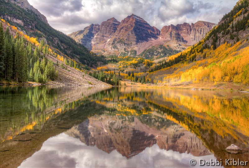
A classic fall image of the Maroon Bells. (Debbi Kibler)
October in Thornton can bring a wide variety of weather conditions, perfect for the photographer in all of us.
The month brings the changing of the colors at Colorado’s lower elevations and it is also is typically when we see our first freeze and first snow.
Couple those facts with our usual widely varying landscapes and wildlife and we have a month that is sure to bring in plenty of photo opportunities.
Slideshow updated November 1, 2015
To learn more about how to send your photo to us for inclusion in the slideshow, see below the slideshow.
Showcasing images captured by ThorntonWeather.com readers as well as some of our own, our monthly slideshow covers the entire gamut of weather-related imagery.
Sunsets, sunrises, wildlife and of course every type of weather condition are vividly depicted in images captured from yours and our cameras.
[flickr_set id=”72157659177525310″]
What is missing in the slideshow above? Your photo!
Our monthly photo slideshow is going to feature images that we have taken but more importantly images that you have captured. The photos can be of anything even remotely weather-related.
Landscapes, current conditions, wildlife, pets, kids. Whimsical, newsy, artsy. Taken at the zoo, some other area attraction, a local park, a national park or your backyard. You name it, we want to see and share it!
Images can be taken in Thornton, Denver or anywhere across the extraordinary Centennial State. We’ll even take some from out of state if we can tie it to Colorado somehow.
We’ll keep the criteria very open to interpretation with just about any image eligible to be shown in our slideshows.
What do you win for having your image in our slideshow? We are just a ‘mom and pop’ outfit and make no money from our site so we really don’t have the means to provide prizes. However you will have our undying gratitude and the satisfaction that your images are shared on the most popular website in Thornton.
To share you images with us and get them included in the slideshow just email them to us or share them with ThorntonWeather.com on any of the various social media outlets. Links are provided below.
The United States returns to Standard Time at 2:00am Sunday as Daylight Saving Time comes to an end.
The biannual ritual of changing our clocks to adjust for Daylight Saving Time occurs tonight providing yet another signal of the changing of seasons. The United States will ‘fall back’ one hour at 2:00am Sunday morning as we return to Standard Time.
The ritual of changing our clocks twice a year can be met with some resistance as some people struggle to adjust their body’s internal clock. Others actually like the return to standard time as they get to enjoy an extra hour of sleep.
The time change definitely has big effects on the dawning of daylight and how early it gets dark in the evening.
Sunrise on Saturday occurs at 7:27am but on Sunday it will be at 6:28am. Similarly, sunset will occur at 5:59pm on Saturday but on Sunday the sun will disappear over the horizon at 4:58pm.
For many this means that when they get home from work it will now be dark and outdoor activities will be significantly curtailed as a result.
Arizona and Hawaii are the only states that do not observe Daylight Saving Time and remain on Standard Time year round. The U.S. territories of Puerto Rico, American Samoa, Guam, Northern Mariana Islands, and the United States Virgin Islands also do not observe the event.
It won’t be all that long though before Daylight Saving Time returns. On March 13, 2016 we will ‘spring forward.’
Daylight Saving Time Schedule
The mandated beginning and end of Daylight Saving Time has changed in the United States over the years.
The most recent schedule was set by the Energy Policy Act of 2005 and took effect in 2007. We now ‘spring forward’ to begin Daylight Saving Time on the second Sunday in March and ‘fall back’ with the return to Standard Time on the first Sunday in November.
Keeping an eye on the sky since October 2006. ThorntonWeather.com is now beginning its 10th year of operation.
It is hard to believe but it was on October 25, 2006 the digital switch was thrown and the first bits of live weather data from our weather station were fed to the Internet. ThorntonWeather.com was born!
Since that date, we are extremely proud of what the site has become – an indispensable community resource for north Denver metro area residents, businesses and governmental agencies.
On the one year anniversary of the site’s launch, we were receiving on average 750 unique visitors a month. On the second anniversary that had grown to around 5,000 visitors a month. For 2015 we are on pace to average well over 25,000 per month!
The response has been absolutely overwhelming to say the least.
We launched the site simply because we wanted to know what was going on with the weather in Thornton and the north Denver metro area. We don’t live downtown, we don’t live at DIA and the differences in weather between Thornton and those other locations can be considerable. Apparently many of you agree!
Our site has not only grown in terms of visitors, but perhaps more importantly in terms of the amount of information available. Certainly we provide the basics of live weather conditions, radar and forecasts.
Did you know ThorntonWeather.com is a completely non-profit venture run by a Thornton resident? We are self-funded but do occasionally receive help from members of the community, something which allows us to keep things up and running. Learn more about how you can help here.
Far more than that, we now have educational information about various weather dangers, historical climate information, satellite imagery, webcams and so much more. Our news and blog section is continually updated with the latest news and information including items important to the community.
Put simply, there is no other media outlet in the state that provides as much weather news, information and content as we do!
Since our launch we have became very ‘social’ with a growing Facebook page, a Twitter feed and a presence on Google +. Interacting with our visitors is an integral part of our site and something we enjoy greatly.
Stay up to date with Thornton’s weather: Be sure to ‘like’ us on Facebook, follow us on Twitter and add us to your Google+ circles.
We’re just ‘weather geeks’ that love the weather and love our community. Running ThorntonWeather.com can be a bit expensive and it is time consuming to maintain and operate it but it is worth it.
We’d like to thank all of our visitors for your support in the past and we look forward to continuing to be the best, truly local source for Thornton weather.
A massive 7.5 magnitude earthquake hit Afghanistan Monday, with its effects felt in parts of Pakistan and India, as well. The earthquake’s epicenter hit Jarm, Afghanistan, a city about 150 miles from Kabul. More than 52 people were killed in Afghanistan and Pakistan, according to local news outlet Dawn, with Al Jazeera reporting casualty tolls higher… Continue reading Major Earthquake Rocks Southeast Asia→
October 25 to October 31: This week in Denver weather history
Halloween week is historically pretty eventful when it comes to weather. Wind is always a factor this time of year as gusty Chinook winds can come flying down the mountains and foothills and cause a great deal of damage. Snow of course also becomes more frequent as we get closer to our second snowiest month (November).
From the National Weather Service:
From the 24th to the 25th:
In 1921…rainfall totaled 0.35 inch overnight behind an apparent cold front. North winds were sustained to 40 mph with gusts to 46 mph on the 25th. Temperatures plunged from a high of 73 degrees on the 24th to a low of 39 degrees on the 25th.
In 1923…rain overnight changed to snow during the morning. The heavy snowfall accumulated to 12.0 inches before ending on the morning of the 25th. Post-frontal north winds were sustained to 22 mph with gusts to 23 mph on the 24th.
In 1997…one of the worst and deadliest blizzards of the decade developed over eastern Colorado as deep east to northeast flow associated with a vigorous upper level low pressure system over the four corners…combined with a strong arctic air mass over the central great plains. Snowfall totals across metro Denver ranged from 14 to 31 inches. The heaviest snowfall occurred in the foothills west and southwest of Denver where 2 to 4 feet of snow were measured. Sustained winds to 40 mph with gusts as high as 60 mph produced zero visibilities and extremely cold wind chill temperatures from 25 below to 40 below zero. Winds whipped the snow into drifts 4 to 10 feet deep. Several major and interstate highways were closed as travel became impossible. Red cross shelters were set up for hundreds of travelers who became stranded when they had to abandon their vehicles. Four people died in northeastern Colorado as a result of the blizzard. None of the deaths were in metro Denver. At Denver International Airport…4 thousand travelers were stranded when the airport was forced to shut down. At least 120 cars were abandoned along Pena Blvd….the only arterial leading into and out of dia. The blizzard cost air carriers at least 20 million dollars. Thousands of cattle died in the storm over northeastern Colorado…resulting in losses totaling 1.5 million dollars. Some of the more impressive snowfall totals included: 51 inches at Coal Creek Canyon; 48 inches at silver spruce ranch…near ward; 42 inches at Intercanyon…in the foothills southwest of Denver; 37 inches at Sedalia; 35 inches at aspen springs and Conifer in the foothills west of Denver; 31 inches at Eldorado Springs… Southeast Aurora…and Englewood; and 30 inches on Table Mesa in Boulder. Snowfall totaled 21.9 inches at the site of the former Stapleton International Airport…setting a new 24-hour snowfall record of 19.1 inches for the month. Snowfall totaled only 14 inches at Denver International Airport where north winds gusted to 39 mph on the 24th. High temperature of only 21 degrees on the 25th equaled the record low maximum for the date first set in 1873. Low temperature of only 3 degrees on the 26th set a new record minimum for the date.
On the 25th:
In 1925…a vigorous cold front produced north winds sustained to 42 mph with gusts to 52 mph. Post-frontal snowfall was only 0.4 inch during the late afternoon and early evening.
In 1959…northwest winds gusted to 55 mph at Stapleton Airport.
In 1997…the high temperature warmed to only 21 degrees… The record low maximum for the month. The same temperature also occurred on October 30…1991.
From the 25th to the 26th:
In 1996…4 to 6 inches of snow fell in the foothills west of Denver. Only 1.5 inches of snowfall were measured at the site of the former Stapleton International Airport on the 26th. This was the only measurable snow of the month at the site. The snowfall produced icy and snowpacked highways…which resulted in a 50-to 60-car pileup on I-25 south of metro Denver. West winds gusted to 33 mph at Denver International Airport.
In 2006…a winter storm brought heavy snowfall to metro Denver and the eastern foothills. Total snowfall ranged from 12 to 22 inches over the higher terrain and 6 to 12 inches across metro Denver. Northerly winds at sustained speeds of 20 to 30 mph with gusts as high as 47 mph at Denver International Airport whipped the snow into drifts 3 to 4 feet deep. Many tree limbs snapped under the weight of the heavy…wet snow which also downed power lines… Leaving thousands of residents without power. Storm total snowfall included: 25 inches near aspen springs…Conifer… And Evergreen; 23.5 inches near Rollinsville; 23 inches in Idaho Springs; 22.5 inches near Blackhawk; 21.5 inches near bailey; 19 inches near Bergen Park; 18 inches near Aspen Springs…Genesee… And Jamestown; 17 inches southwest of Boulder; 16 inches in Evergreen; and 15 inches near Georgetown and Perry Park. Snowfall totaled 5.3 inches in the Denver Stapleton area. At Denver International Airport…rain…including a thunderstorm… Changed to snow on the evening of the 25th after a high temperature of 70 degrees.
In 2010…a storm system brought heavy snow to the mountains west of Denver. Storm totals included: 24 inches at the Eisenhower Tunnel…18 inches at Loveland Ski Area; with 16 inches at Arapahoe Basin.
From the 25th to the 27th:
In 1897…a major storm dumped 13.5 inches of snowfall over downtown Denver. Rain changed to snow during the evening of the 25th and continued through mid-morning of the 27th. Most of the snow…12.0 inches… Fell on the 26th when north winds were sustained to 36 mph and gusts were as high as 46 mph. Temperatures during the storm were in the 20`s and lower 30`s. Precipitation (rain and melted snow) totaled 1.21 inches.
On the 26th:
In 1995…winds gusting from 100 to near 110 mph pounded the foothills northwest of Denver. At Nederland winds gusted to 100 mph and to 70 mph in Coal Creek Canyon. Atop Squaw Mountain west of Denver wind gusts to 108 mph were recorded. The strong winds downed some trees and caused power outages. West-northwest winds gusted to 47 mph at Denver International Airport.
In 2010…very strong winds during the day knocked down power lines in parts of Boulder. The downed electrical lines sparked a small brush fire near Columbine Elementary School. Strong wind gusts also damaged the tennis bubble at the Millennium Harvest House. In Northglenn, a tree was knocked down and caused minor damage to a mini-van parked nearby. Peak wind gusts included: 70 mph at Berthoud…67 mph at Rocky Mountain Metropolitan airport in Broomfield… 63 mph at the Rocky Flats National Wind Technology Center and 59 mph at the NCAR Mesa Laboratory…3 miles southwest of Boulder. West winds gusted to 43 mph at Denver International Airport.
In 2011…a powerful early season storm brought heavy snow to the Front Range and adjacent plains. The heavy…wet snow caused extensive downed large branches and in some cases…entire trees. Massive power outages occurred from Fort Collins and Greeley south to Denver and the surrounding metro area. Most of the trees still had their leaves…which helped to catch snow and down trees under the weight of the moisture laden snow. Nearly two hundred thousand utility customers along the Front Range were without heat and electricity for several hours. The Red Cross opened four temporary shelters overnight until the power could be restored. The outages also forced the closure of the Boulder criminal justice center the following day. The fallen trees and branches also caused extensive property damage to roofs and automobiles. In the Front Range mountains and foothills…storm totals included 19.8 inches…3 miles west of Jamestown; 18 inches…5 miles west of Copper; 13 inches… 3 miles north of Blackhawk and 3 miles south of Evergreen…4 miles east-northeast of Nederland and Lake Eldora; 12 inches at Berthoud SNOTEL. Across the urban corridor storm totals included: 11.5 inches in Boulder; 9.5 inches at the National Weather Service in Boulder; 9 inches…1 mile southwest of Westminster; 8.5 inches in Broomfield… Denver International Airport…Frederick and Louisville; 8 inches in Aurora…7 inches in Watkins; with 6 inches in Arvada.
From the 26th to the 27th:
In 1971…strong winds raked Boulder. At the National Bureau of Standards wind gusts to 62 mph were recorded…while in downtown Boulder winds peaked to 48 mph. At Stapleton International Airport…northwest winds gusted to 38 mph on the 26th and north winds gusted to 36 mph on the 27th.
In 1976…the first measurable snow of the season turned into a major storm. Traffic was halted for several hours on highways to the west of Denver where 8 to 12 inches of snow fell in the foothills. Snowfall totaled 7.2 inches at Stapleton International Airport where north winds gusted to 30 mph. Most of the snow…6.3 inches… Fell all day on the 26th. The greatest snow depth on the ground was 5 inches on the morning of the 27th.
On the 27th:
In 1980…the first snowfall of the season totaled only 1.5 inches with 0.10 inch of moisture at Stapleton International Airport where the maximum snow depth on the ground was only 1 inch due to melting. This was the only measurable precipitation of the month…making it the driest October since 1962 when only 0.03 inch of precipitation was measured.
In 1994…wind gusts to 70 mph were recorded atop squaw mountain…5 miles south of Idaho Springs… And at Rollinsville in the foothills southwest of Boulder. Northwest winds gusted to 28 mph at Stapleton International Airport.
From the 27th to the 28th:
In 1874…strong west winds in Boulder along with a reported tornado produced 150 dollars in damage.
In 1913…a strong cold front produced sustained northeast winds to 35 mph with gusts as high as 38 mph on the 27th. Overnight snowfall totaled 5.8 inches. Temperatures plunged to a low of 17 degrees on the morning of the 28th after a high of 60 degrees on the 27th.
From the 27th to the 30th:
In 2009…a powerful early season storm brought heavy snow to the Front Range. The combination of a deep northeasterly upslope flow coupled with abundant moisture and lift with the developing storm system produced an extended period of moderate to heavy snowfall. The heavy wet snow accumulated on trees and resulted in broken branches and scattered electrical outages. Interstates 70 and 76 were closed east of Denver. Numerous other roads and highways were shut down. The Red Cross set up numerous emergency shelters for stranded travelers. The blowing snow at Denver International Airport forced the cancellation of hundreds of flights. Schools were also closed. In the foothills storm totals included: 46 inches… 3 miles southeast of Pinecliffe; 42 inches…3 miles southwest of Conifer; 34 inches…3 miles north of Blackhawk; 30 inches at Aspen Springs and near Evergreen… 23 inches at Roxborough Park…and 20 inches… 3 miles south-southeast of Morrison. Across the urban corridor storm totals included: 25 inches in Highlands Ranch; 21.5 inches near Louisville…20.5 inches in Broomfield… 20 inches at Lafayette…17.5 inches in Boulder… 17 inches in Westminster…16.5 inches in Erie; 15.5 inches in Arvada and 5 miles west-northwest of Littleton…15 inches in Littleton…14 inches in Englewood… 13.5 inches in Lakewood and 6 miles north of Thornton; 13.3 inches at Denver International Airport…11 inches… 4 miles south of Denver; 10.5 inches…2 miles north of Cherry Hills Village and Niwot.
On the 28th:
In 1917…post-frontal snowfall totaled 6.5 inches in the city. North winds sustained to 30 mph with gusts to 33 mph caused the temperature to plunge from a high of 58 degrees to a low of 9 degrees by midnight.
In 1967…winds gusted to 65 mph in downtown Boulder… Causing minor damage. South winds gusted to 32 mph at Stapleton International Airport.
In 1991…the first major snow of the season hit metro Denver as a cold arctic air mass moved over the area. Snowfall amounts across northeast Colorado ranged from 3 to 10 inches with 4.4 inches of snowfall recorded at Stapleton International Airport where north winds gusted to 22 mph. The low temperature dipped to 13 degrees.
In 1993…high winds buffeted the Front Range foothills. A wind gust to 83 mph was recorded atop squaw mountain…35 miles west of Denver…and a gust to 76 mph occurred near Rollinsville southwest of Boulder.
From the 28th to the 29th:
In 1993…an upper level disturbance combined with a moist upslope flow to bring heavy snow to portions of metro Denver. Snowfall amounts ranged from 5.4 inches at Stapleton International Airport to 14 inches in Boulder. New snowfall totaled 8 inches at Gross Reservoir in the foothills 5 miles southwest of Boulder. On the 28th…north winds gusted to 30 mph at Stapleton International Airport where the temperature climbed to only 25 degrees on the 29th…equaling the record low maximum for the date.
From the 28th to the 30th:
In 1971…a vigorous cold front plunged temperatures from a high of 70 degrees on the 27th to record low levels on the 29th and 30th. Snowfall totaled 3.1 inches at Stapleton International Airport where north winds gusted to 23 mph. Some freezing drizzle also fell on the 28th. Record daily low maximum temperatures of 32 degrees on the 28th and 25 degrees on the 29th were established along with a daily record minimum of 13 degrees on the 30th.
From the 28th to the 31st:
In 1929…rain changed to snow on the afternoon of the 28th and continued until midday on the 30th followed by intermittent light snow which continued through the 31st. Snowfall over the four days totaled 16.2 inches in the city. Most of the snow…8.5 inches… Fell on the 29th with 6.1 inches on the 30th. Temperatures hovered in 20`s during most of the storm.
On the 29th:
In 1917…the all-time lowest recorded temperature in October…2 degrees below zero… occurred. This is also the earliest below zero reading of the season.
In 1939…the first measurable snow of the season totaled 5.6 inches in downtown Denver. Post-frontal northeast winds were sustained to 28 mph.
In 1961…heavy snowfall measured 6.0 inches at Stapleton Airport where northeast winds gusted to 30 mph.
In 1973…strong winds caused some damage to homes…stores… And utility lines along the foothills from metro Denver south.
In 1981…high winds buffeted the Front Range foothills with gusts to 55 mph in south Boulder.
In 1996…high winds gusting from 70 to around 100 mph blasted metro Denver. One man was killed when a strong wind gust overturned a pop-up camper onto him while he was trying to secure it. In addition…five people at the Rocky Flats Environmental Test Facility received minor injuries when several windshields were blown out of their cars…spraying glass onto the occupants. Several trees and power lines were also downed. Two 75-foot high pine trees were uprooted at the Mt. Olivet cemetery in Arvada. Property damage from the windstorm ran into the millions of dollars. The highest recorded wind gusts included: 101 mph at Jefferson County Airport near Broomfield…100 mph in Golden Gate Canyon… 96 mph in Coal Creek Canyon…and 87 mph at upper Table Mesa in Boulder. West-northwest winds gusted to 43 mph at Denver International Airport. Insured damage from the wind storm totaled 5.2 million dollars…the third most costly storm of record in Colorado at the time.
In 2003…strong Chinook winds developed in and near the Front Range foothills. Winds gusting to 80 mph in Boulder downed several trees and power lines…causing damage and triggering scattered electrical outages. The combination of strong winds…very dry fuel conditions… And downed power lines sparked two large wildfires. The overland wildfire in Boulder County…near Jamestown… Consumed nearly 3900 acres and destroyed 12 structures…including homes…trailers… And out-buildings. Preliminary damage estimates for the value of lost property was nearly one million dollars. In Douglas County…the Cherokee Ranch Wildfire consumed 1200 acres and destroyed 4 structures. The large smoke plumes from both fires were highly visible across metro Denver. West winds gusted to 45 mph at Denver International Airport.
It is a familiar refrain from climate change alarmists: This latest wildfire (or hurricane or tornado or rain event) is the worst we have ever seen and manmade climate change is to blame. The fact is though that these over-the-top claims rarely are true.
Certainly California has seen some devastating wildfires this season. Governor Jerry Brown was quick to jump on the ‘blame climate change’ bandwagon.
With the Rocky Fire still smoldering in northern California, the governor used his bully pulpit to push his agenda:
“California is burning,” the governor dramatically declared. “What the hell are you going to do about it?
“This is a wake-up call. We have to start coming to our senses. This is not a game of politics. We need to limit our carbon pollution. These are real lives and real people. This problem cannot be solved year by year.”
“The fires are changing…. The way this fire performed, it’s not the way it usually has been. Going in lots of directions, moving fast, even without hot winds.”
Governor Brown’s statements do sound dire and make one believe that the wildfires and their behavior are unprecedented. However, as the LA Times reported yesterday, the link between the blazes and climate change is tenuous at best.
But scientists who study climate change and fire behavior say their work does not show a link between this year’s wildfires and global warming, or support Brown’s assertion that fires are now unpredictable and unprecedented. There is not enough evidence, they say.
University of Colorado climate change specialist Roger Pielke said Brown is engaging in “noble-cause corruption.”
Pielke said it is easier to make a political case for change using immediate and local threats, rather than those on a global scale, especially given the subtleties of climate change research, which features probabilities subject to wide margins of error and contradiction by other findings.
“That is the nature of politics,” Pielke said, “but sometimes the science really has to matter.”
Historical fire suppression policies and land management are considered to be far larger concerns and are more likely to have contributed to the wildfires.
Wildfires are of course not the only natural disaster that gets blamed on climate change. Indeed, many have blamed the Golden State’s drought on global warming but there is little evidence to back the claim. In a study, NOAA said, “natural oceanic and atmospheric patterns are the primary drivers behind California’s ongoing drought.”
Despite the facts that show these events are cyclical and natural, you can be assured political leaders and activist scientists will continue to use them to push their climate change agenda.
Weather, natural disasters & climate news and information.


 The weather during the month of November in Denver metro area can offer just about anything. While it is normally a quiet month, it can be prone to extremes.