October 19th to October 25th - This week in Denver weather history.
Snow and wind seem to dominate a look back at Denver weather history for this week. Perhaps most notably, the October blizzard of 1997 occurred this week in history, one of the deadliest storms in Colorado history.
PUBLIC INFORMATION STATEMENT
NATIONAL WEATHER SERVICE DENVER CO
645 PM MDT SAT OCT 18 2008
…THIS WEEK IN METRO DENVER WEATHER HISTORY…
17-19 IN 1908…A MOIST…HEAVY…WET SNOWFALL TOTALED 13.0 INCHES IN
DOWNTOWN DENVER OVER THE 3 DAYS. RAIN FROM EARLY MORNING
ON THE 17TH CHANGED TO SNOW BY LATE AFTERNOON AND CONTINUED
THROUGH THE LATE MORNING OF THE 19TH. DUE TO TEMPERATURES
IN THE 30`S AND MELTING…THE MOST SNOW ON THE GROUND WAS
ONLY 5.0 INCHES AT 6:00 PM ON THE 18TH. NORTHWEST TO
NORTHEAST WINDS WERE SUSTAINED BETWEEN 12 AND 20 MPH DURING
THE STORM. PRECIPITATION TOTALED 1.82 INCHES.
18-23 IN 2003…AN EXTENDED WARM SPELL RESULTED IN 5 NEW TEMPERATURE
RECORDS. THE HIGH TEMPERATURE OF 84 DEGREES ON THE 18TH
EQUALED THE RECORD HIGH FOR THE DATE. HIGH TEMPERATURES
OF 86 DEGREES ON THE 19TH…83 DEGREES ON THE 21ST…AND 84
DEGREES ON THE 22ND WERE RECORD HIGHS FOR THE DATES. LOW
TEMPERATURE OF 49 DEGREES ON THE 23RD WAS A RECORD HIGH
MINIMUM FOR THE DATE. LOW TEMPERATURES DURING THE PERIOD
WERE IN THE 40`S AND LOWER 50`S.
October 12th to the 18th - This week in Denver weather history.
Looking back into the Denver weather history books shows Denver can receive just about any kind of weather this time of year. From heavy snow to gale force winds to 80 plus degree temperatures, it can all happen this week.
10-12 IN 1969…THE SECOND HEAVY SNOWSTORM IN LESS THAN A WEEK
DUMPED NEARLY A FOOT OF SNOW ACROSS METRO DENVER AND
PLUNGED THE AREA INTO EXTREMELY COLD TEMPERATURES FOR SO
EARLY IN THE SEASON. SNOWFALL TOTALED 11.0 INCHES AT
STAPLETON INTERNATIONAL AIRPORT. NORTH WINDS GUSTING TO
26 MPH PRODUCED DRIFTS UP TO 2 FEET DEEP. TEMPERATURES
DIPPED FROM A HIGH OF 52 DEGREES ON THE 10TH TO A RECORD
LOW FOR THE DATE OF 10 DEGREES ON THE 12TH. THERE WAS
ADDITIONAL DAMAGE TO TREES AND POWER AND TELEPHONE LINES
FROM HEAVY SNOW ACCUMULATIONS AND ICING. TRAVEL WAS
RESTRICTED OR BLOCKED BY DRIFTING SNOW IN BOTH THE
MOUNTAINS AND ON THE PLAINS EAST OF DENVER.
This week in Denver weather history - October 5th to October 11th
In our weekly look back at Denver weather history, we see a wide range of weather has occurred in the past. From thunderstorms to rain to big time snowstorms, we can and have seen it all.
3-5 IN 1984…THE REMNANTS OF PACIFIC HURRICANE POLO PRODUCED
HEAVY RAIN OVER NORTHEASTERN COLORADO. MOST LOCATIONS
RECEIVED BETWEEN 1.00 TO 2.50 INCHES OF RAIN…BUT 3.45
INCHES FELL IN LITTLETON. RAINFALL TOTALED 1.73 INCHES
AT STAPLETON INTERNATIONAL AIRPORT…WHERE NORTH WINDS
GUSTED TO 24 MPH.
4-5 IN 1997…UNUSUALLY WARM WEATHER RESULTED IN TWO TEMPERATURE
RECORDS. HIGH TEMPERATURE OF 87 DEGREES ON THE 4TH EXCEEDED
THE OLD RECORD SET IN 1922 BY ONE DEGREE. HIGH TEMPERATURE
OF 86 DEGREES ON THE 5TH EQUALED THE RECORD SET IN 1990 AND
PREVIOUS YEARS.
As part of a special “Best of” series on Examiner.com, I recently penned an article about what was one of the most significant storms in Denver history – the 1982 Christmas Eve blizzard. It is republished here as I thought everyone might like to check it out:
Looking back through history, Denver and Colorado have had some extraordinary weather stories. When looking to pick a “best” or most significant weather event, reaching far back into the history books one might choose the Georgetown blizzard of 1913 which dumped an astonishing 86 inches of snow or perhaps the Big Thompson Flood of 1976 which claimed 145 lives. More recently, there were the holiday storms of 2006 or the Windsor tornadoes from 2007. But, there is one storm that historically stands out not only because of its severity in terms of the weather but also because of the long lasting impact it caused in Denver and Colorado which is still being felt today – the Christmas Eve Blizzard of 1982. For those of you that didn’t live in Colorado then or are too young to remember, a trip through the history books shows why this storm was so significant. Those that do remember it have memories that will last a lifetime.
This week in Denver weather history - September 27- October 4
A new weekly feature for ThorntonWeather.com – This Week in Denver Weather History. The National Weather Service maintains a historical archives of weather history across the nation and makes it available to the public. ThorntonWeather.com will start publishing that information weekly.
So, let’s stroll down memory lane with This Week in Denver Weather History.
26-28 IN 1936…THE HEAVIEST SNOWFALL EVER RECORDED IN SEPTEMBER
AND THE HEAVIEST SNOWFALL EVER RECORDED SO EARLY IN THE
SEASON DUMPED A TOTAL OF 16.5 INCHES OF SNOW ON DOWNTOWN
DENVER AND 21.3 INCHES AT DENVER MUNICIPAL AIRPORT. THE
15.0 INCHES OF SNOW MEASURED FROM 6:00 PM ON THE 27TH TO
6:00 PM ON THE 28TH IS THE GREATEST 24 HOUR SNOWFALL EVER
RECORDED IN SEPTEMBER. THIS WAS THE FIRST SNOW OF THE
SEASON. THE SNOW WAS INTERMITTENT THROUGH THE 26TH…BUT
CONTINUOUS FROM EARLY AFTERNOON ON THE 27TH TO AROUND
MIDNIGHT ON THE 28TH…EXCEPT FOR A PERIOD OF RAIN DURING
THE AFTERNOON OF THE 28TH WHICH CONTRIBUTED TO A LOSS OF
DEPTH ON THE GROUND. THE GREATEST SNOW DEPTH ON THE GROUND
DOWNTOWN WAS 13 INCHES WITH 8 INCHES AT DENVER MUNICIPAL
AIRPORT. THERE WERE NO HIGH WINDS WITH THE STORM AND
TRAFFIC WAS INTERRUPTED FOR ONLY A SHORT PERIOD. THE
STORM PRODUCED PROPERTY DAMAGE ESTIMATED AT 7 MILLION
DOLLARS. WITH TREES AND SHRUBS IN FULL FOLIAGE…THE LEAVES
CAUGHT AND HELD THE HEAVY WATER-LADEN SNOW…UNTIL THE
BRANCHES SNAPPED FROM THE WEIGHT. MORE THAN 3000 WORKMEN
WERE CALLED TO REMOVE THE DEBRIS AND SNOW FROM THE CITY. THE
CITY FIREMEN WHO WERE OFF DUTY…AS WELL AS ALL THE RESERVES…
WERE ASKED TO REPORT TO THEIR STATIONS. ALL SCHOOLS IN THE
CITY REMAINED OPEN…BUT ATTENDANCE WAS ONLY 50 PERCENT OF
NORMAL. GRADE SCHOOL STUDENTS WERE SENT HOME AT NOON ON THE
28TH. THE EARLY STORM CAUGHT STOCKMEN WITH MANY CATTLE STILL
IN HIGHER RANGES. WARM WEATHER FOLLOWED THE SNOW…WHICH HAD
ALL MELTED BY THE END OF THE MONTH…EXCEPT FOR A FEW INCHES
IN SHELTERED PLACES.
August is usually one of nicer weather months as summer winds down and temperatures cool. The Democratic National Convention will be in Denver August 25th to August 28th and chances are the weather will be just fine. A look back at historical weather events on those days though shows some interesting things have occurred in Denver weather history.
Some of the highlights in Denver weather history include:
August 1875 saw grasshopper swarms in Denver.
August 25
In 1875 in the period from August 19th to the 20th grasshoppers appeared in great numbers in Denver. Weather records say the “streets were literally covered with them” and swarms were seen on each day. All gardens in the city were ruined as were many rural crops. News stories say that on the 30th the grasshoppers were so numbers as to “almost darken the sun.”
In 1910, the lowest temperatures every recorded in August – 40 degrees – was recorded on August 24, 25 and 26.
In 1951 a microburst produced a 50 mph gust of wind at Stapleton International Airport. In 1964 thunderstorm winds gusted to 59 mph.
More recently, in 1994, lightning struck a power pole in Louisville causing a two hour power outage.
August 26
The aforementioned grasshopper plague and low temperatures occurred on this date.
In 1944 one of the most destructive hail storms in the city caused nearly one million dollars in damage as it struck between 2:00 and 3:00pm. Hail from very small to 1 ½ inches was reported and covered the ground to depths up to six inches in some areas. Downtown Denver recorded 0.95 inch of rain and heavy hail. News reports of the day report people being cut by broken glass, people being stranded by flooded cars, sewers backing up as they were unable to handle the deluge, buildings being flooded, trees stripped, telephone poles downed and more. The next day the American Red Cross was designated by the War Department to grant any and all priorities needed to repair the damage.
In 1961 two workmen suffered a broken foot and bruises when severe winds blew in the walls of a warehouse under construction.
On the 26th and 27th in 1980, two thunderstorms hit Arvada and Westminster dumping 1.5 inches of rain in an hour. Streets were washed out and homes and cars sustained damage. Three homes in Arvada sustained damage from lightning.
August 27
The 1875 grasshopper invasion continued.
Lightning is always a danger in Colorado.
In 1967 a young woman that was horseback riding in west Denver was killed when she was struck by lightning; the horse died soon thereafter. Another woman and young man riding with her were injured when they were thrown from their horses. Lightning also did damage to houses in Arvada in 2003 and Parker in 2005.
1996 saw some excitement in the Fort Lupton area when 2 – 3 inches of rain fell in a 45 minute span. A local college suffered damage when its roof leaked. A weak F0 tornado was also reported in the area.
Not so long ago in 2002 large hail struck the metro area on this date. Hail as large as 2 inches was reported in Jefferson County as well as 1.5 inches in Golden and Lakewood, 1 ¼ inches in Nederland, and 1 inch hail in Elizabeth, Louviers, Rollinsville and Blackhawk.
2004 saw a cold spell hit the Denver area. That year on the 27th the high temperature only reached 55 degrees setting a record low maximum for the date. The low temperature of 48 tied the record low as well.
August 28
Yes, the grasshopper swarm in 1875 continued.
The cold spell in 2004 yielded a low temperature on this date of 42 degrees setting a record.
1968, lightning again reared its ugly head. One man was seriously injured while riding a roller coaster at Denver Amusement Park. An airline employee was injured by lightning while working on a plane at Stapleton International Airport. Also, lightning caused serious damage to a Denver house and minor damage to several others.
Also on this date…. In 2002 a thunderstorm produced ¾ inch hail in Parker and in 2005 lightning sparked a small fire near Jamestown.
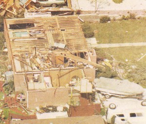
On June 3, 1981 a tornado struck Thornton in what is the worst twister to have struck the Denver metro area. Image courtesy the City of Thornton archives.
I always tell the story of me being in 6th grade at Hillcrest Elementary in Northglenn on June 3, 1981. Sitting at our desks the principal comes over the intercom and announces that all students need to get under their desks. I look outside and see that it is dark as night – at least it seemed to be to a scared 12 year old!
Not long after, a tornado touched down a few miles away along Washington Street in Thornton destroying 25 homes and injuring 53 people.
In a recent series on the history of Washington Street, the Northglenn-Thornton Sentinel revisited that day and the damage the tornado caused. It is fascinating reading whether you have lived here long enough to remember it or not.

 As part of a special “Best of” series on