With the landscape tinder dry and conditions ripe for wildfires, Adams County has announced a burn ban in all unincorporated areas. Effective immediately, absolutely no open burning is allowed.
[Adams County Sheriff’s Sgt. Paul] Gregory said the fire ban did not apply to fires within liquid fuels or gas stoves, fireplaces inside buildings and charcoal or propane grill fires at private residences. Fires within permanent fire grates in developed campgrounds are OK. So is burning household trash within a fireproof container that won’t let flame or burning material escape from the bottom of the container. Gregory said the container has to be in the center of an area that is 10 feet in diameter “from which all flammable material has been removed.”
The ban only applies to unincorporated areas of the county so is not applicable to Thornton residents within city limits. Click the image below for a look at the restrictions. To date we have not seen any fire ban ordered by the City of Thornton.
As the sun went down yesterday a thunderstorm moved over the Thornton area. It provided some brief, heavy rain which was very welcome given our drought stricken landscape. Accompanying the moisture was a good bit of lightning which lit up the post-sunset sky.
Our west facing webcam captured one bolt as it struck turning night into day for a brief instant.
A thunderstorm on June 23, 2013 delivered rain and a good bit of lightning. ThorntonWeather.com’s west facing camera happened to capture one bolt as it struck.
Under the influence of strong high pressure, the mercury soared in the Mile High City on Monday and two temperature records fell.
As measured at Denver International Airport, the mercury reached a high of 99 degrees at 2:53 p.m. This broke the previous record high temperature for June 10 of 97 degrees set in 1952.
Here in Thornton we were hot but not quite as hot. Our high temperature topped out at 97 degrees at 2:35 p.m. This is the highest temperature we have seen thus far this year and the highest reading in Thornton since July 21, 2012 (97.9 degrees).
If you thought the nighttime would bring relief from the heat, you were mistaken. Denver’s official “low” temperature on Monday was only 68 degrees. This set a new record high minimum for the date easily besting the previous record holder of 64 degrees last set in 1990. Thornton was just slightly cooler with a low for the date of 66.8 degrees.
There won’t be much of a break in the heat in the coming days. While it will be cooler than today, temperatures for the rest of the week are expected to continue to be well above normal. Get the latest forecast here.
Following on colder and wetter than normal weather in previous months, Thornton’s May returned us to drier and warmer than normal conditions.
The month started out with a bit of a wintry blast of cold temperatures and snow. In fact, Denver even set an all-time May low temperature on the 2nd of the month.
The cold and snow that started the month were probably overall the most notable feature of the month. The rest of May was not particularly extraordinary in any aspect.
Denver’s average temperature for the month was 57.9 degrees. This was 0.8 degrees above average. Here in Thornton we were just slightly cooler with an average temperature of 57.6 degrees.
Thornton’s temperatures ranged from a high of 89.2 degrees on the 14th down to a low of 20.7 degrees on the morning of the 2nd. Denver saw a maximum temperature of 88 and a low of 19 degrees.
Official Denver temperature records for the month included:
DAILY RECORDS:
DATE TEMPERATURE TYPE OF RECORD OLD RECORD YEAR LAST SET
MAY 2ND 19 DEGREES RECORD LOW 22 DEGREES 1954
MAY 14TH 87 DEGREES TIED RECORD HIGH 87 DEGREES 1996
MONTHLY RECORDS:
DATE TEMPERATURE TYPE OF RECORD OLD RECORD YEAR LAST SET
MAY 2ND 19 DEGREES TIED RECORD LOW 19 DEGREES MAY 3RD 1907
In terms of precipitation, Denver recorded only 0.82 inches, far below the average for May of 2.12 inches. Here in Thornton Mother Nature was far more generous as we recorded 2.35 inches.
The snow that started the month totaled 4.3 inches in Thornton, 3.4 inches in Denver. Both were well above the May average of 1.1 inches snowfall.
The unseasonably warm weather this week reached record setting levels today. At 1:55pm the temperature at Denver International Airport reached 87° tying the record high temperature for the date previously set on May 14, 1996.
Here in Thornton we were a couple of degrees warmer as the mercury climbed to 89°. This is the warmest temperature we have recorded since September 10 of last year (91°).
Don’t miss a thing when it comes to our ever changing weather! Be sure to ‘like’ us on Facebook, follow us on Twitter and add us to your Google+ circles.
Denver’s recent cold continued as this morning one low temperature record was broken, another tied.
In the wake of our May Day snowstorm, clear skies the following morning allowed temperatures to plummet and reach very winter-like levels. As the mercury bottomed out, Denver broke one low temperature record and tied another.
As measured at Denver International Airport, the temperature this morning dropped to 19 degrees at 6:41am. This easily breaks the previous record low temperature for May 2 of 22 degrees set in 1954.
Most notably, the 19 degree reading also tied the record for the lowest temperature ever recorded during the month of May since record keeping began in Denver in 1872. We have to go all the way back to May 3, 1907 to find a reading that low during May.
Here in Thornton we were quite cold as well although not quite as much as DIA. Our morning low temperature of 20.7 degrees was seen at 6:00am.
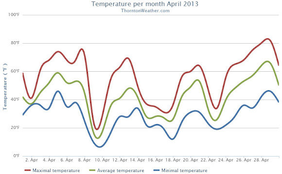
The cold and snowy start to May mimics what was seen during the month of April. Last month Denver recorded its fifth coldest and 11th snowiest April on record.
When we look back at April 2013 it will be remembered for two key things: the cold and the snow. By both measurements the month saw extremes with temperatures well below normal and well above normal snowfall, the third month in a row we experienced those conditions.
A series of storm systems moved through during April providing regular doses of cold and snow. Three systems from the 9th of the month through the 25th, each coming at the start of the workweeks, provided the notable conditions. Seventeen of those 18 days saw below normal temperatures.
Denver’s official average temperature for the month came in at 41.7 degrees. This was an impressive 5.7 degrees below the 1981 – 2000 historical average. This put April 2013 into the books as the fifth coldest April since recordkeeping began in Denver. Thornton was only slightly better with an April average temperature of 42.3 degrees.
On four days Denver failed to see high temperatures climb above freezing, Thornton registered three such days.
Five cold temperature records were setting during the month. Record lows were set on April 9th, April 10th and April 22nd. The record low was tied on April 16th. A record low maximum was recorded on the 9th as well.
Temperatures ranged from a high of 80 degrees on the 29th down to a low of 6 degrees on the 10th in Denver. Thornton’s temperatures were similar with a high of 81.7 degrees on the 29th and a low temperature for the month of 6.7 degrees on the 10th.
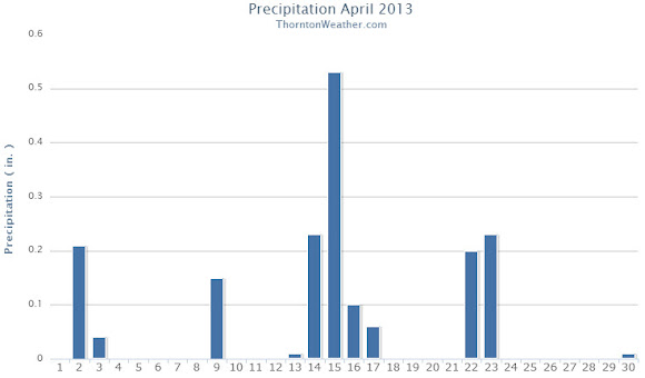
The precipitation was the second half of the April 2013 story with plenty of that falling, primarily in the form of snow.
Denver officially recorded 1.87 inches of liquid precipitation, just a bit above the April average of 1.71 inches. Thornton was just a touch drier with 1.77 inches of precipitation.
Snow was in abundance as Denver saw 20.4 inches of snowfall as measured at Denver International Airport. Thornton was trailing with 19.1 inches. Both marks were well above the Denver April normal of 6.8 inches. Denver’s measurement fell just short of making the list of 10 snowiest Aprils with April 2013 ranking as the 11th snowiest.
Thornton, Colorado April 2013 Temperatures.Thornton, Colorado April 2013 precipitation.
From the National Weather Service:
...THE DENVER CO CLIMATE SUMMARY FOR THE MONTH OF APRIL 2013...

CLIMATE NORMAL PERIOD 1981 TO 2010
CLIMATE RECORD PERIOD 1872 TO 2013

WEATHER         OBSERVED          NORMAL  DEPART  LAST YEAR`S
                 VALUE   DATE(S)  VALUE   FROM    VALUE  DATE(S)
                                          NORMAL
................................................................
TEMPERATURE (F)
RECORD
 HIGH              90   04/30/1992
 LOW               -2   04/02/1975
HIGHEST            80   04/29        83      -3       88  04/24
LOWEST              6   04/10        -2       8       24  04/07
AVG. MAXIMUM     54.7              61.5    -6.8     68.6
AVG. MINIMUM     28.7              33.3    -4.6     37.9
MEAN             41.7              47.4    -5.7     53.3
DAYS MAX >= 90      0               0.0     0.0        0
DAYS MAX <= 32      4               0.3     3.7        0
DAYS MIN <= 32     17              13.0     4.0        4
DAYS MIN <= 0       0               0.0     0.0        0
PRECIPITATION (INCHES)
RECORD
 MAXIMUM         8.24   1900
 MINIMUM         0.03   1963
TOTALS           1.87              1.71    0.16     1.39
DAILY AVG.       0.06              0.06    0.00     0.05
DAYS >= .01        13               9.1     3.9        8
DAYS >= .10         7               4.5     2.5        4
DAYS >= .50         0               0.9    -0.9        0
DAYS >= 1.00        0               0.5    -0.5        0
GREATEST
 24 HR. TOTAL    0.50   04/22 TO 04/23           04/26 TO 04/27

SNOWFALL (INCHES)
RECORDS
 TOTAL           33.8  1933
TOTALS           20.4               6.8

DEGREE_DAYS
HEATING TOTAL     690               529     161      352
 SINCE 7/1       5802              5731      71     5215
COOLING TOTAL       0                 1      -1        6
 SINCE 1/1          0                 1      -1        6

FREEZE DATES
RECORD
 EARLIEST     09/08/1962
 LATEST       06/08/2007
EARLIEST                        10/07
LATEST                          05/05
....................................................

WIND (MPH)
AVERAGE WIND SPEED              11.0
RESULTANT WIND SPEED/DIRECTION   1/016
HIGHEST WIND SPEED/DIRECTION    49/290    DATE  04/14
HIGHEST GUST SPEED/DIRECTION    55/350    DATE  04/08

SKY COVER
POSSIBLE SUNSHINE (PERCENT)   MM
AVERAGE SKY COVER           0.70
NUMBER OF DAYS FAIR            2
NUMBER OF DAYS PC             20
NUMBER OF DAYS CLOUDY          8

AVERAGE RH (PERCENT)     53

WEATHER CONDITIONS. NUMBER OF DAYS WITH
THUNDERSTORM              1     MIXED PRECIP               0
HEAVY RAIN                1     RAIN                       3
LIGHT RAIN               10     FREEZING RAIN              0
LT FREEZING RAIN          0     HAIL                       0
HEAVY SNOW                3     SNOW                       6
LIGHT SNOW                8     SLEET                      0
FOG                      12     FOG W/VIS <= 1/4 MILE      5
HAZE                     11

-  INDICATES NEGATIVE NUMBERS.
R  INDICATES RECORD WAS SET OR TIED.
MM INDICATES DATA IS MISSING.
T  INDICATES TRACE AMOUNT.
Denver recorded a record low temperature on the morning of April 23, the fifth cold temperature record of the month that has been tied or broken.
Just before midnight last night the mercury dropped to 21 degrees at Denver International Airport setting a record low temperature for the date of April 22. The breaks the previous record for the date of 22 degrees set 139 years ago in 1874.
Here in Thornton we couldn’t quite match that with a low temperature yesterday of 22.6 degrees.
Illustrating just how cold it was, the average low temperature for both yesterday’s and today’s date is 35 degrees. To date Denver’s average temperature during the month of April is an amazing 7.5 degrees below average.
This record is the fifth cold temperature weather record set or tied this month. Record low temperatures have previously been recorded on April 9, April 10 and April 16. Also, a record low maximum was measured on April 9.
Mother Nature can be a fickle lady as we are now seeing. While the calendar says spring, she is quite content to visit wintry weather on us once again.
As expected a three-day long event is occurring that will bring heavy, wet snow to the area and winter-like temperatures. While not unusual for this time of year, it certainly has many longing for the delayed arrival of spring.
We will be monitoring monitoring the storm very closely and posting regularly to our Facebook page and Twitter feed. You can follow along in real time below. We are also on Google+ here.
Denver set its fourth cold temperature record so far this month.
Our unseasonably cold April continues. Following a healthy show of snow yesterday temperatures dropped this morning to a low of 22 degrees as measured at Denver International Airport. This ties the record low for the date last set in 1999.
Here in Thornton we matched DIA’s number with a low of 22 degrees this morning. Both marks are far below the Denver low temperature average for April 16 of 33 degrees.
This is the fourth cold temperature related record set so far this month.


 Under the influence of strong high pressure, the mercury soared in the Mile High City on Monday and two temperature records fell.
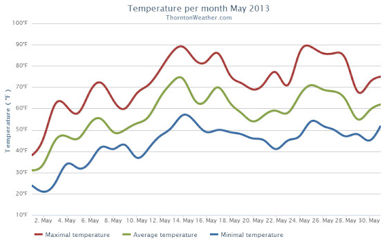


 Mother Nature can be a fickle lady as we are now seeing. While the calendar says spring, she is quite content to visit wintry weather on us once again.