As we begin the new year the winter chill begins to set in. While January can see its share of extremes, the month historically sees stable temperatures and is usually relatively dry.
January ranks as the second coldest month in Denver next to December with average temperatures remaining virtually the same from the start to the end of the month. In terms of snowfall, the month only ranks as the fourth snowiest and it is not uncommon for it to be quite dry.
What does January 2013 hold for us? Indications are that we may very well continue the recent pattern of below normal temperatures and relatively dry conditions.
Our recent blast of Arctic air sent the mercury tumbling and in the process broke two daily records for December 30th.
The official “high” temperature in Denver, as measured at DIA, reached only 1 degree at 1:23pm. This easily bested the record low high for the date of 8 degrees set in 1915. Thornton was slightly warmer than the airport with a high temperature of 2.4 degrees.
Additionally, at 9:23pm, the mercury plummeted to -19 degrees at DIA. This crushes the old record low temperature for December 30 of -11 degrees set in 1898. Here in Thornton we did not get quite as cold with a low temperature reading of -12.1 degrees occurring at 10:50pm.
Stay up to date with Thornton’s weather: Be sure to ‘like’ us on Facebook, follow us on Twitter and add us to your Google+ circles.
December 14, 2014 – Ducks and geese seek high ground in Thornton. (Tony’s Takes)
The month of December can offer everything from bone dry conditions to bone chilling cold and monstrous snowstorms. The weather and wildlife all afford an abundance of photo opportunities as our December photo slideshow shows.
Leaves have fallen from trees now and the landscape can sometimes look quite stark. However it only takes a quick shot of snow to change that picture greatly. Throw in gorgeous sunrises and sunsets, plenty of wildlife big and small, kids playing and much more and the month can be quite colorful and eventful.
Slideshow updated December 29, 2014
To learn more about how to send your photo to us for inclusion in the slideshow, see below the slideshow.
Showcasing images captured by ThorntonWeather.com readers as well as some of our own, our monthly slideshow covers the entire gamut of weather-related imagery.
Sunsets, sunrises, wildlife and of course every type of weather condition are vividly depicted in images captured from yours and our cameras.
[flickr_set id=”72157649883515106″]
What is missing in the slideshow above? Your photo!
Our monthly photo slideshow is going to feature images that we have taken but more importantly images that you have captured. The photos can be of anything even remotely weather-related.
Landscapes, current conditions, wildlife, pets, kids. Whimsical, newsy, artsy. Taken at the zoo, some other area attraction, a local park, a national park or your backyard. You name it, we want to see and share it!
Images can be taken in Thornton, Denver or anywhere across the extraordinary Centennial State. We’ll even take some from out of state if we can tie it to Colorado somehow.
We’ll keep the criteria very open to interpretation with just about any image eligible to be shown in our slideshows.
What do you win for having your image in our slideshow? We are just a ‘mom and pop’ outfit and make no money from our site so we really don’t have the means to provide prizes. However you will have our undying gratitude and the satisfaction that your images are shared on the most popular website in Thornton.
To share you images with us and get them included in the slideshow just email them to us or share them with ThorntonWeather.com on any of the various social media outlets. Links are provided below.
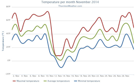
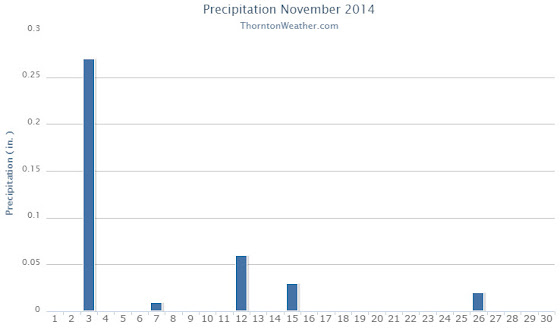
The month of November this year was one that saw some widely varying temperatures from comfortable fall readings to bone chilling cold. Precipitation ran light and while we saw our first measurable snows for the season, it was still dry.
With a high pressure ridge above, the month started out quite nice. A cold front moved through on the third and not only cooled things down, but also brought the bulk of our precipitation for the month in the form of rain.
We then saw a week of unseasonably warm conditions that lasted through the 10th. After that, the bottom fell out and the mercury plunged. Five of the next six days failed to climb above freezing as bone-chilling cold more akin to January was seen. We did manage to record more than two inches of snow over the same period.
A largely seasonal weather pattern then settled in with most of the next nine days having readings not too far from average. Three of the last four days of the month then brought back very mild conditions.
Thornton’s overall average temperature for the month was 35.1 degrees. This was well below the long term November average for Denver of 38.3 degrees. Out at the airport, official Denver readings were a bit warmer with an average of 36.2 degrees.
Thornton’s warmest reading in November came on the 29th with maximum of 72.5 degrees. The coldest was -8.8 degrees on the morning of the 13th. Denver’s maximum was similar to ours at 72 degrees but its coldest was a bit further down there at -14 degrees.
Five temperature records were set for the month, only one was for a warm reading. That came on the 9th with a record high minimum.
On the other hand, demonstrating just how significant the cold blast in the middle of the month was, Denver set four cold temperature related records for the month. These included record low maximums on the 11th and 12th and record lows on the 12th and 13th.
In terms of precipitation, Thornton finished below average while Denver was slightly above. The November average is 0.61 inches. Here in Thornton we had a mere 0.39 inches while DIA recorded 0.76.
November is one of our snowiest months but that was certainly not the case this year. While the long term average is 8.7 inches, Thornton recorded only 3.0 inches and Denver 4.0 inches.
November 2014 temperature summary for Thornton, Colorado. (ThorntonWeather.com)November 2014 precipitation summary for Thornton, Colorado. (ThorntonWeather.com)
From the National Weather Service:
CLIMATE REPORT
NATIONAL WEATHER SERVICE BOULDER, CO
144 AM MST MON DEC 1 2014

...................................

...THE DENVER CO CLIMATE SUMMARY FOR THE MONTH OF NOVEMBER 2014...

CLIMATE NORMAL PERIOD 1981 TO 2010
CLIMATE RECORD PERIOD 1872 TO 2014

WEATHER         OBSERVED          NORMAL  DEPART  LAST YEAR`S
                 VALUE   DATE(S)  VALUE   FROM    VALUE  DATE(S)
                                          NORMAL
................................................................
TEMPERATURE (F)
RECORD
 HIGH              80   11/08/2006
 LOW              -18   11/29/1877
HIGHEST            72   11/29        73       7       71  11/13
                        11/01
LOWEST            -14   11/13         6      -8       12  11/21
AVG. MAXIMUM     50.6              52.1    -1.5     55.1
AVG. MINIMUM     21.8              24.5    -2.7     26.7
MEAN             36.2              38.3    -2.1     40.9
DAYS MAX >= 90      0               0.0     0.0        0
DAYS MAX <= 32      5               2.3     2.7        2
DAYS MIN <= 32     22              23.4    -1.4       25
DAYS MIN <= 0       4               0.6     3.4        0
PRECIPITATION (INCHES)
RECORD
 MAXIMUM         3.21   1946
 MINIMUM            T   1899
                        1901
                        1949
TOTALS           0.76              0.61    0.15     0.27
DAILY AVG.       0.03              0.02    0.01     0.01
DAYS >= .01         6               4.7     1.3        3
DAYS >= .10         3               1.6     1.4        1
DAYS >= .50         0               0.0     0.0        0
DAYS >= 1.00        0               0.0     0.0        0
GREATEST
 24 HR. TOTAL    0.30   11/03 TO 11/03           11/21 TO 11/21

SNOWFALL (INCHES)
RECORDS
 TOTAL           42.6   1946
TOTALS            4.0               8.7

DEGREE_DAYS
HEATING TOTAL     857               801      56      715
 SINCE 7/1       1254              1382    -128     1323
COOLING TOTAL       0                 0       0        0
 SINCE 1/1        701               769     -68      999

FREEZE DATES
RECORD
 EARLIEST     09/08/1962
 LATEST       06/08/2007
EARLIEST                        10/07
LATEST                          05/05
..................................................

WIND (MPH)
AVERAGE WIND SPEED              10.1
RESULTANT WIND SPEED/DIRECTION   3/228
HIGHEST WIND SPEED/DIRECTION    43/040    DATE  11/10
HIGHEST GUST SPEED/DIRECTION    54/040    DATE  11/10

SKY COVER
POSSIBLE SUNSHINE (PERCENT)   MM
AVERAGE SKY COVER           0.60
NUMBER OF DAYS FAIR            4
NUMBER OF DAYS PC             21
NUMBER OF DAYS CLOUDY          5

AVERAGE RH (PERCENT)     53

WEATHER CONDITIONS. NUMBER OF DAYS WITH
THUNDERSTORM              1     MIXED PRECIP               1
HEAVY RAIN                1     RAIN                       2
LIGHT RAIN                2     FREEZING RAIN              0
LT FREEZING RAIN          0     HAIL                       0
HEAVY SNOW                1     SNOW                       3
LIGHT SNOW                7     SLEET                      0
FOG                       8     FOG W/VIS <= 1/4 MILE      1
HAZE                      5

-  INDICATES NEGATIVE NUMBERS.
R  INDICATES RECORD WAS SET OR TIED.
MM INDICATES DATA IS MISSING.
T  INDICATES TRACE AMOUNT.
The month of December brings with it the official start of winter and oftentimes, colder and snowier weather conditions. It however can also offer unseasonably warm temperatures and bone dry conditions.
Through November, the snow season along the Colorado Front Range has been dismal. With a mere 4.0 inches of snow having been recorded in Denver (3.0 in Thornton), seasonal snowfall is 9.0 inches below normal.
December can prove to be a rebound month and help bolster those numbers. However precipitation can be hit or miss as while monster snowstorms are possible, we have also seen starkly dry years.
Current long range forecasts point to a warm start to the month followed by seasonal conditions.
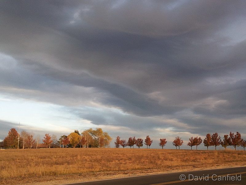
November 7, 2014 – Gorgeous clouds at sunrise. (David Canfield)
Typically November is a quiet weather month with plenty of nice, fall days but it can also turn wet with plenty of snow and moisture. Between the widely varying weather conditions and our normally gorgeous scenery, photo opportunities abound.
Many of the leaves have fallen by now and those that haven’t will be gone by the end of the month as colder temperatures and snow take their toll. The change in seasons does bring an increase in wildlife activity including the return of bald eagles to our area.
Slideshow updated November 30, 2014
To learn more about how to send your photo to us for inclusion in the slideshow, see below the slideshow.
Showcasing images captured by ThorntonWeather.com readers as well as some of our own, our monthly slideshow covers the entire gamut of weather-related imagery.
Sunsets, sunrises, wildlife and of course every type of weather condition are vividly depicted in images captured from yours and our cameras.
What is missing in the slideshow above? Your photo!
Our monthly photo slideshow is going to feature images that we have taken but more importantly images that you have captured. The photos can be of anything even remotely weather-related.
Landscapes, current conditions, wildlife, pets, kids. Whimsical, newsy, artsy. Taken at the zoo, some other area attraction, a local park, a national park or your backyard. You name it, we want to see and share it!
Images can be taken in Thornton, Denver or anywhere across the extraordinary Centennial State. We’ll even take some from out of state if we can tie it to Colorado somehow.
We’ll keep the criteria very open to interpretation with just about any image eligible to be shown in our slideshows.
What do you win for having your image in our slideshow? We are just a ‘mom and pop’ outfit and make no money from our site so we really don’t have the means to provide prizes. However you will have our undying gratitude and the satisfaction that your images are shared on the most popular website in Thornton.
To share you images with us and get them included in the slideshow just email them to us or share them with ThorntonWeather.com on any of the various social media outlets. Links are provided below.
Yet another cold weather record fell this morning as the mercury dropped.
As measured at Denver International Airport, the low temperature this morning plunged to -14 degrees. This easily bested the record low temperature for November 13 of -3 degrees set in 1916.
Here in Thornton the mercury didn’t fall quite as far. Our morning low was -8.8 degrees.
Our bone-chilling blast of cold air continued its record-setting ways on Wednesday as two cold temperature records fell.
The official high temperature for the day only reached 6 degrees in Denver as measured at Denver International Airport. This easily bested the previous record low maximum for the date of 9 degrees set in 1916. Here in Thornton we were slightly warmer with a high of 8.4 degrees.
Additionally, clearing skies late in the day aided in sending the mercury plunging after dark leading to the second record.
Before midnight the temperature dropped to a miserable -13 degrees at DIA. This shattered the previous record low temperature for November 12 of -4 degrees set 132 years ago in 1882. Thornton managed to stay quite a bit warmer, dropping only to -4.7 degrees just before midnight.
The Mile High City will also be setting a record low temperature for November 13. The old record of -3 degrees was set in 1916. We will have to see how cold it gets in the early morning hours to see what the final number ends up being.
Stay up to date with Thornton’s weather: Be sure to ‘like’ us on Facebook, follow us on Twitter and add us to your Google+ circles.
New record low maximum temperature set in Denver today.
The high temperature in the Mile High City topped out at 16 degrees at 12:46pm today. This crushed the old record for the date of 19 degrees set 98 years ago in 1916. Here in Thornton we were only slightly warmer today with a high of 17 degrees.
Looking ahead, more records may fall in the next 48 hours or so.
Tomorrow’s record low max of 9 degrees, also set in 1916, could fall with current forecasts calling for a high of only 7 degrees. Also, with low temperatures tomorrow night forecast to drop to -5 degrees, we could set a record low temperature for November 13 (-3 degrees in 1916).
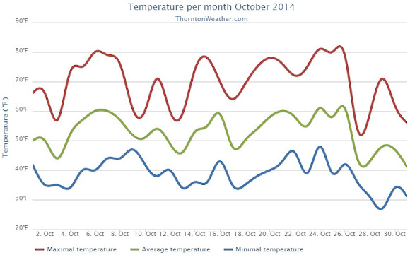
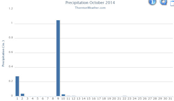
Generally pleasant, unseasonably warm temperatures were the highlight of October 2014 in Thornton. The month was also notable for its distinct lack of snow.
We started out the first few days of the month with cooler than normal conditions and a good shot of rain on the first. We rebounded quickly though as high pressure built and warmer weather returned including an 80 degree temperature reading on the 6th. Four out of five days between the 9th and 13th were cooler than normal but then warmer temperatures dominated through to the 26th of the month. The final days saw cooler conditions for the most part.
Overall, Thornton’s average temperature for the month was 52.7 degrees. This was a good ways above the Denver long term average for October of 50.9 degrees.
Out at the airport, Denver’s official average was even warmer at 55.2 degrees. This was close to making the top 10 list of warmest Octobers as number 10 is 55.4 degrees (1910).
Thornton’s warmest reading was 81 degrees on the 24th and its coldest was a chilly 27.1 degrees on the morning of the 28th. Denver saw its warmest reading of 83 degrees on the 15th and its coldest of 29 degrees on the 27th.
Denver set or tied four temperature records during the month. A new record high maximum was set for the 15th (83 degrees) and 24th (82 degrees). The record high for the 25th was tied (80 degrees) and the record high minimum for the 26th was tied (49 degrees).
In terms of precipitation, Thornton saw above average rainfall in its bucket while Denver was below. In all, 1.43” fell in Thornton although the vast majority of that was on two days (the 1st and 9th). Denver International Airport recorded only 0.52 inches. Denver’s average for October is 1.02 inches.
Neither Thornton nor Denver recorded any snowfall during the month. On average the Mile High City sees 4.0 inches of the white stuff.
Thornton, Colorado October 2014 temperature summary.Thornton, Colorado October 2014 precipitation summary.
From the National Weather Service:
CLIMATE REPORT
NATIONAL WEATHER SERVICE BOULDER, CO
804 AM MDT SAT NOV 1 2014

...................................

...THE DENVER CO CLIMATE SUMMARY FOR THE MONTH OF OCTOBER 2014...

CLIMATE NORMAL PERIOD 1981 TO 2010
CLIMATE RECORD PERIOD 1872 TO 2014

WEATHER         OBSERVED          NORMAL  DEPART  LAST YEAR`S
                 VALUE   DATE(S)  VALUE   FROM    VALUE  DATE(S)
                                          NORMAL
................................................................
TEMPERATURE (F)
RECORD
 HIGH              90   10/01/1892
 LOW               -2   10/29/1917
HIGHEST            83   10/15        83       0       79  10/08
LOWEST             29   10/27        22       7       27  10/16
                                                          10/05
AVG. MAXIMUM     69.7              65.3     4.4     60.0
AVG. MINIMUM     40.7              36.6     4.1     35.5
MEAN             55.2              50.9     4.3     47.7
DAYS MAX >= 90      0               0.0     0.0        0
DAYS MAX <= 32      0               0.4    -0.4        0
DAYS MIN <= 32      4               8.5    -4.5       12
DAYS MIN <= 0       0               0.0     0.0        0
PRECIPITATION (INCHES)
RECORD
 MAXIMUM         4.17   1969
 MINIMUM            T   1934
TOTALS           0.52              1.02   -0.50     0.72
DAILY AVG.       0.02              0.03   -0.01     0.02
DAYS >= .01         5               5.3    -0.3        8
DAYS >= .10         2               2.4    -0.4        3
DAYS >= .50         0               0.5    -0.5        0
DAYS >= 1.00        0               0.1    -0.1        0
GREATEST
 24 HR. TOTAL    0.26   10/09 TO 10/10           10/18 TO 10/18

SNOWFALL (INCHES)
RECORDS
 TOTAL           31.2   1969
TOTALS            0.0               4.0

DEGREE_DAYS
HEATING TOTAL     296               440    -144      525
 SINCE 7/1        394               581    -187      608
COOLING TOTAL       0                 5      -5        0
 SINCE 1/1        701               769     -68      999

FREEZE DATES
RECORD
 EARLIEST     09/08/1962
 LATEST       06/08/2007
EARLIEST      10/03             10/07
LATEST                          05/05
.....................................................

WIND (MPH)
AVERAGE WIND SPEED              9.1
RESULTANT WIND SPEED/DIRECTION   3/197
HIGHEST WIND SPEED/DIRECTION    35/020    DATE  10/02
HIGHEST GUST SPEED/DIRECTION    44/010    DATE  10/02

SKY COVER
POSSIBLE SUNSHINE (PERCENT)   MM
AVERAGE SKY COVER           0.50
NUMBER OF DAYS FAIR           11
NUMBER OF DAYS PC             17
NUMBER OF DAYS CLOUDY          3

AVERAGE RH (PERCENT)     49

WEATHER CONDITIONS. NUMBER OF DAYS WITH
THUNDERSTORM              0     MIXED PRECIP               0
HEAVY RAIN                1     RAIN                       1
LIGHT RAIN                8     FREEZING RAIN              0
LT FREEZING RAIN          0     HAIL                       0
HEAVY SNOW                0     SNOW                       0
LIGHT SNOW                0     SLEET                      0
FOG                       4     FOG W/VIS <= 1/4 MILE      0
HAZE                      8

-  INDICATES NEGATIVE NUMBERS.
R  INDICATES RECORD WAS SET OR TIED.
MM INDICATES DATA IS MISSING.
T  INDICATES TRACE AMOUNT.

.....OCTOBER 2014 WARMER AND DRIER THAN AVERAGE.....

OCTOBER 2014 STARTED OUT COOLER THAN NORMAL AS AN UPPER LEVEL TROUGH
OF LOW PRESSURE MOVED ACROSS THE CENTRAL AND NORTHERN ROCKY MOUNTAIN
STATES. THIS SYSTEM BROUGHT SOME LIGHT RAIN TO DENVER ON THE FIRST.
WARMER TEMPERATURES MOVED INTO NORTH CENTRAL AND NORTHEASTERN
COLORADO BY THE 5TH AS UPPER LEVEL HIGH PRESSURE BUILT OVER THE
WESTERN UNITED STATES. COOLER TEMPERATURES AND PRECIPITATION MOVED
INTO THE FRONT RANGE OF COLORADO ON THE 9TH AS A WEAK UPPER LEVEL
TROUGH AND ASSOCIATED COLD FRONT MOVED ACROSS THE REGION. UPPER
LEVEL HIGH PRESSURE REBUILT OVER THE REGION ON THE 14TH...WITH A 13
DAY STRETCH OF ABOVE NORMAL TEMPERATURES AT DENVER INTERNATIONAL
AIRPORT FROM THE 14TH THROUGH THE 26TH. THE TEMPERATURE REACHED OR
EXCEEDED THE 80 DEGREE MARK ON ON THE 15TH, 24TH AND 25TH. ANOTHER
UPPER LEVEL STORM SYSTEM AND COLD FRONT BROUGHT COOLER TEMPERATURES
TO NORTHEASTERN COLORADO ON THE 27TH AND 28TH...WITH TEMPERATURES
RETURNING TO SLIGHTLY ABOVE NORMAL VALUES THE LAST FEW DAYS OF THE
MONTH.

TEMPERATURES:

THE AVERAGE TEMPERATURE AT DENVER INTERNATIONAL AIRPORT FOR THE
MONTH OF OCTOBER WAS 55.2 DEGREES F WHICH WAS 4.3 DEGREES ABOVE
NORMAL. OCTOBER OF 1950 WAS THE WARMEST OCTOBER ON RECORD...WITH AN
AVERAGE TEMPERATURE OF 59.9 DEGREES F.  THE COLDEST OCTOBER ON
RECORD WAS 39.0 DEGREES F BACK IN 1969. THERE WERE NO DAYS IN WHICH
THE MAXIMUM TEMPERATURE EXCEEDED 90 DEGREES. THE HIGHEST TEMPERATURE
OF THE MONTH WAS 83 DEGREES WHICH OCCURRED ON THE 15TH. THE COLDEST
TEMPERATURE OF THE MONTH WAS 29 DEGREES OCCURRED ON THE MORNING OF
THE 27TH.

DAILY RECORDS:

DATE      TEMPERATURE    TYPE OF RECORD    OLD RECORD   YEAR LAST SET

OCT 15TH  83 DEGREES     RECORD HIGH MAX   82 DEGREES       2011
OCT 24TH  82 DEGREES     RECORD HIGH MAX   80 DEGREES       2011
OCT 25TH  80 DEGREES     TIED HIGH MAX     80 DEGREES       2007
OCT 26TH  49 DEGREES     TIED HIGH MIN     49 DEGREES       1927

PRECIPITATION:

PRECIPITATION FOR THE MONTH OF OCTOBER AT DENVER INTERNATIONAL
AIRPORT WAS 0.52 INCHES...WHICH IS 0.50 INCHES BELOW THE NORMAL OF
1.02 INCHES. THERE WERE 4 DAYS WITH MEASURABLE PRECIPITATION. ON THE
9TH...0.25 INCHES OF PRECIPITATION FELL WHICH IS THE GREATEST DAILY
AMOUNT FOR THE MONTH.

TEN WETTEST OCTOBER`S IN DENVER WEATHER HISTORY SINCE 1872:

4.17 INCHES 1969
3.92 INCHES 1892
3.72 INCHES 1942
3.50 INCHES 1923
3.47 INCHES 1984
3.05 INCHES 1914
3.03 INCHES 2007
2.84 INCHES 1947
2.62 INCHES 1957
2.46 INCHES 1959, 1960

TEN DRIEST OCTOBER`S IN DENVER WEATHER HISTORY SINCE 1872:

 T   INCHES 1934
0.01 INCHES 1933
0.05 INCHES 1944, 1962
0.06 INCHES 1948, 1954, 1988
0.08 INCHES 2001, 2003
0.10 INCHES 1980
0.12 INCHES 1876, 1938, 1950
0.17 INCHES 1907
0.18 INCHES 1952, 1964
0.19 INCHES 1879, 1894, 1927

TEN SNOWIEST OCTOBER`S IN DENVER WEATHER HISTORY SINCE 1872:

31.2 INCHES 1969
22.7 INCHES 1906
22.1 INCHES 1997
17.8 INCHES 1923
17.2 INCHES 2009
16.4 INCHES 1897
16.2 INCHES 1929
14.0 INCHES 1889
13.8 INCHES 1905
13.6 INCHES 1908

THERE WERE 3 DAYS IN WHICH THUNDER WAS OBSERVED AT DENVER
INTERNATIONAL AIRPORT...NO DAYS WITH HAIL AND NO DAYS WITH DENSE FOG
WITH A VISIBILITY AT OR BELOW 1/4 MILE DURING THE MONTH. A PEAK WIND
OF 44 MPH FROM A NORTHERLY DIRECTION WAS RECORDED ON THE 2ND.
Weather, natural disasters & climate news and information.
 As we begin the new year the winter chill begins to set in. While January can see its share of extremes, the month historically sees stable temperatures and is usually relatively dry.
 Our recent blast of Arctic air sent the mercury tumbling and in the process broke two daily records for December 30th.
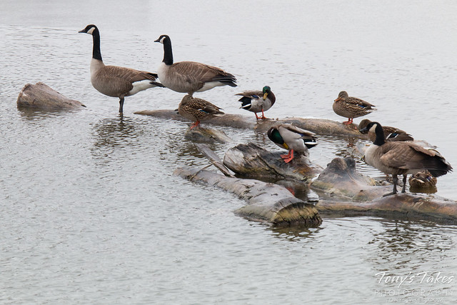
 The month of December brings with it the official start of winter and oftentimes, colder and snowier weather conditions. It however can also offer unseasonably warm temperatures and bone dry conditions.