Category Archives: Thornton Weather

Denver sets record low temperature for May 10

Record Cold TemperaturesTo go along with our Mother’s Day snow, we also have seen some cold – record-setting cold in fact.
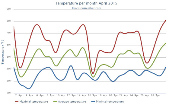
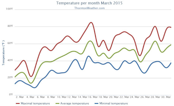
Denver’s official low temperature, as measured at Denver International Airport, dropped to 27 degrees this morning.  That ties the record low for today’s date set previously in 1946.

Here in Thornton we were just a little bit warmer with a low of 28 degrees this morning.

In terms of snowfall, Denver reported 4.0 inches at DIA as of 7:00am this morning.  Here in Thornton we received 5.1 inches.

Looking ahead, the record low for May 11 is 28 degrees (also in 1946).  With clearing skies later today and into tonight, it wouldn’t be surprising to see that mark tied or broken tomorrow AM.

Stay up to date with Thornton’s weather: Be sure to ‘like’ us on Facebook, follow us on Twitter and add us to your Google+ circles.

April 2015 weather recap: Thornton sees warmer, wetter than normal conditions

We began the month of April in the need of moisture and while we didn’t do much to bolster our snowfall numbers, rain proved to be a big help.  Temperatures were relatively stable but did end up a bit above average.

The first half of the month offered mostly dry conditions and warmer than normal temperatures.  The only real exception was a light snowfall on the 2nd and 3rd of the month.  Otherwise we saw virtually no precipitation for the first 15 days of April.

The latter half however saw a shift in the weather pattern courtesy of a number of storm systems that moved through.  These led to cooler temperatures and some nice shots of precipitation.

A system on the 15th and 16th brought only 3.9 inches of snowfall but a healthy 1.68 inches of liquid precipitation from snowmelt and rain.  We then remained mostly dry up until the 26th when another good shot of rain arrived.

Thornton’s average temperature for April 2015 was 49.0 degrees, a good bit above the long term April average of 47.4 degrees.  Out at the airport, Denver saw similar readings to ours with an average of 48.7 degrees.

Temperatures in Thornton ranged from a low of 24.0 degrees on the morning of the 4th up to a high of 80.7 degrees on the 30th.  Denver’s coldest reading was 27 degrees on the 3rd and its warmest came on the 30th with a temperature of 79 degrees.

In terms of precipitation, Thornton saw 2.68 inches of precipitation for the month.  Officially, as measured at DIA, Denver took a very similar 2.65 inches into their bucket.  Both readings were a good ways above the April average of 1.71 inches.

Snowfall failed to be anything extraordinary.  Both Thornton and Denver saw 5.3 inches of the white stuff, a good bit below the average of 6.8 inches.

Click here to view Thornton’s April 2015 climate report.

Thornton, Colorado temperatur?e summary for April 2015. (ThorntonW?eather.com?)
Thornton, Colorado precipitat?ion summary for April 2015. (ThorntonW?eather.com?)

From the National Weather Service:

CLIMATE REPORT
NATIONAL WEATHER SERVICE BOULDER, CO
552 AM MDT FRI MAY 1 2015

...................................

...THE DENVER CO CLIMATE SUMMARY FOR THE MONTH OF APRIL 2015...

CLIMATE NORMAL PERIOD 1981 TO 2010
CLIMATE RECORD PERIOD 1872 TO 2015

WEATHER         OBSERVED          NORMAL  DEPART  LAST YEAR`S
                 VALUE   DATE(S)  VALUE   FROM    VALUE  DATE(S)
                                          NORMAL
................................................................
TEMPERATURE (F)
RECORD
 HIGH              90   04/30/1992
 LOW               -2   04/02/1975
HIGHEST            79   04/30                         80  04/22
LOWEST             27   04/03                         18  04/14
AVG. MAXIMUM     62.1              61.5     0.6     62.8
AVG. MINIMUM     35.3              33.3     2.0     35.2
MEAN             48.7              47.4     1.3     49.0
DAYS MAX >= 90      0               0.0     0.0        0
DAYS MAX <= 32      0               0.3    -0.3        0
DAYS MIN <= 32      7              13.0    -6.0       10
DAYS MIN <= 0       0               0.0     0.0        0 
PRECIPITATION (INCHES) 
RECORD 
 MAXIMUM         8.24   1900 
 MINIMUM         0.03   1963 
TOTALS           2.65              1.71    0.94     1.24 
DAILY AVG.       0.09              0.06    0.03     0.04 
DAYS >= .01         9               9.1    -0.1        6
DAYS >= .10         6               4.5     1.5        5
DAYS >= .50         2               0.9     1.1        0
DAYS >= 1.00        1               0.5     0.5        0
GREATEST
 24 HR. TOTAL    1.41   04/16 TO 04/17           04/02 TO 04/03

SNOWFALL (INCHES)
RECORDS
TOTAL            33.8   1933
TOTALS            5.3               6.8

DEGREE_DAYS
HEATING TOTAL     481               529     -48      472
 SINCE 7/1       5205              5731    -526     5730
COOLING TOTAL       0                 1      -1        0
 SINCE 1/1          0                 1      -1        0

FREEZE DATES
RECORD
 EARLIEST     09/08/1962
 LATEST       06/08/2007
EARLIEST                        10/07
LATEST                          05/05
....................................................

WIND (MPH)
AVERAGE WIND SPEED              10.7
HIGHEST WIND SPEED/DIRECTION    41/350    DATE  04/15
HIGHEST GUST SPEED/DIRECTION    52/280    DATE  04/12

SKY COVER
POSSIBLE SUNSHINE (PERCENT)   MM
AVERAGE SKY COVER           0.60
NUMBER OF DAYS FAIR            7
NUMBER OF DAYS PC             16
NUMBER OF DAYS CLOUDY          7

AVERAGE RH (PERCENT)     58

WEATHER CONDITIONS. NUMBER OF DAYS WITH
THUNDERSTORM              6     MIXED PRECIP               0
HEAVY RAIN                2     RAIN                       7
LIGHT RAIN               11     FREEZING RAIN              0
LT FREEZING RAIN          0     HAIL                       1
HEAVY SNOW                1     SNOW                       3
LIGHT SNOW                4     SLEET                      0
FOG                      10     FOG W/VIS <= 1/4 MILE      5
HAZE                      3

-  INDICATES NEGATIVE NUMBERS.
R  INDICATES RECORD WAS SET OR TIED.
MM INDICATES DATA IS MISSING.
T  INDICATES TRACE AMOUNT.

April 2015 top shots: Monthly photo slideshow

A total lunar eclipse was one of the highlights of April 2015. (Patrick Martin)

April can be a tricky month weather-wise with everything from mild temperatures to snow to severe weather being possible.  The good thing about that is that it provides plenty of chances for great photos!

April marks a transition between winter and summer for most of the country but for Denver it is especially true as we can see a stunning variety of weather.  The proverbial April showers are certainly a possibility for Denver. Snow? Tornadoes? Thunderstorms? You bet – all can happen!

Throw in our usual wildlife plus the wide variety of birds that return to the Centennial State for the spring and summer and there is a lot going on.

  • Slideshow updated April 30, 2015. To learn more about how to send your photo to us for inclusion in the slideshow, see below the slideshow.

Showcasing images captured by ThorntonWeather.com readers as well as some of our own, our monthly slideshow covers the entire gamut of weather-related imagery.

Sunsets, sunrises, wildlife and of course every type of weather condition are vividly depicted in images captured from yours and our cameras.

[flickr_set id=”72157649591335084″]

What is missing in the slideshow above?  Your photo!

Our monthly photo slideshow is going to feature images that we have taken but more importantly images that you have captured.  The photos can be of anything even remotely weather-related.

Landscapes, current conditions, wildlife, pets, kids.  Whimsical, newsy, artsy.  Taken at the zoo, some other area attraction, a local park, a national park or your backyard.  You name it, we want to see and share it!

Images can be taken in Thornton, Denver or anywhere across the extraordinary Centennial State.  We’ll even take some from out of state if we can tie it to Colorado somehow.

We’ll keep the criteria very open to interpretation with just about any image eligible to be shown in our slideshows.

What do you win for having your image in our slideshow?  We are just a ‘mom and pop’ outfit and make no money from our site so we really don’t have the means to provide prizes.  However you will have our undying gratitude and the satisfaction that your images are shared on the most popular website in Thornton.

To share you images with us and get them included in the slideshow just email them to us or share them with ThorntonWeather.com on any of the various social media outlets.  Links are provided below.

So come on, get those camera’s rolling!

March 2015 weather recap: Dry conditions, warm temperatures month’s biggest feature

The month of March was relatively uneventful and lacked any sort of real weather drama.  What was notable was the dry conditions and unseasonably warm temperatures that dominated for the most part.

March started out considerably colder than normal with the first five days of the month seeing temperatures around 20 degrees below normal.  A light shot of snow was recorded on the fourth of the month, a reading that would be our biggest snowfall for the period.

Temperatures began to turn warmer on the sixth with above normal readings recorded through the 16th of the month.  We even managed two 80+ degree days on the 15th and 16th.

Denver actually saw its earliest 80 degree reading in history on the 16th.  The previous earliest 80 degree reading occurred on March 18, 1907.

Unsettled conditions interrupted the warmth on the 25th with a light snowfall and colder temperatures.

We then bounced right back to the dry, mild conditions for the balance of the month.

Thornton’s average temperature for the month came in at 44.9 degrees.  This was well above the long term Denver average of 40.4 degrees.  Out at DIA, the Mile High City’s reading was very similar at 45.0 degrees.

Temperatures in Thornton ranged from a high of 82.6 degrees on the 16th down to a low of 9.2 degrees on the 5th of the month.  At the airport, Denver’s maximum for the month of 81 degrees came on the 16th with its lowest of 2 degrees on the 5th.

Denver officially broke two temperature records in March 2015.  On March 6th the high temperature of 79 degrees broke the record high for the date (previously 76 degrees set in 2013).  Also, on the 16th, the high temperature reading of 81 degrees was a record (previously 75 degrees in 2012).

In terms of precipitation, the rain bucket totals fell well short of the March average of 0.92 inch.  Here in Thornton a mere 0.49 inches was recorded while Denver saw quite a bit more with a measurement of 0.79 inches.

March is historically our snowiest month but that was certainly not the case in 2015.  Thornton snowfall totally only 2.8 inches and Denver was at 2.9 inches. Both were well below the average of 10.7 inches.

Click here to view Thornton’s March 2015 climate report.

Thornton, Colorado March 2015 Temperature Summary. (ThorntonWeather.com)
Thornton, Colorado March 2015 Precipitation Summary. (ThorntonWeather.com)
CLIMATE REPORT
NATIONAL WEATHER SERVICE BOULDER, CO
633 AM MDT WED APR 1 2015

...................................

...THE DENVER CO CLIMATE SUMMARY FOR THE MONTH OF MARCH 2015...

CLIMATE NORMAL PERIOD 1981 TO 2010
CLIMATE RECORD PERIOD 1872 TO 2015

WEATHER         OBSERVED          NORMAL  DEPART   LAST YEAR`S
                 VALUE   DATE(S)  VALUE   FROM    VALUE  DATE(S)
                                          NORMAL
................................................................
TEMPERATURE (F)
RECORD
 HIGH              84   03/26/1971
 LOW              -11   03/28/1886
HIGHEST            81   03/16/2015                    73  03/09
LOWEST              2   03/05/2015                     4  03/02
AVG. MAXIMUM     58.9              54.4     4.5     55.8
AVG. MINIMUM     31.2              26.4     4.8     25.9
MEAN             45.0              40.4     4.6     40.9
DAYS MAX >= 90      0               0.0     0.0        0
DAYS MAX <= 32      2               1.9     0.1        2
DAYS MIN <= 32     12              23.6   -11.6       23
DAYS MIN <= 0       0               0.1    -0.1        0 
PRECIPITATION (INCHES)
 RECORD
  MAXIMUM         4.56   1983
  MINIMUM         0.03   2012 
TOTALS           0.79              0.92   -0.13     0.83 
DAILY AVG.       0.03              0.03    0.00     0.03 
DAYS >= .01         5               5.9    -0.9        9
DAYS >= .10         3               2.4     0.6        2
DAYS >= .50         0               0.3    -0.3        0
DAYS >= 1.00        0               0.1    -0.1        0
GREATEST
 24 HR. TOTAL    0.34   03/19 TO 03/19

SNOWFALL (INCHES)
TOTALS            2.9              10.7

DEGREE_DAYS
HEATING TOTAL     611               763    -152      739
 SINCE 7/1       4724              5202    -478     5258
COOLING TOTAL       0                 0       0        0
 SINCE 1/1          0                 0       0        0

FREEZE DATES
RECORD
 EARLIEST     09/08/1962
 LATEST       06/08/2007
EARLIEST                        10/07
LATEST                          05/05
........................................................

WIND (MPH)
AVERAGE WIND SPEED              9.9
RESULTANT WIND SPEED/DIRECTION   3/198
HIGHEST WIND SPEED/DIRECTION    36/260    DATE  03/23
HIGHEST GUST SPEED/DIRECTION    45/260    DATE  03/23

SKY COVER
AVERAGE SKY COVER           0.50
NUMBER OF DAYS FAIR           12
NUMBER OF DAYS PC             12
NUMBER OF DAYS CLOUDY          7

AVERAGE RH (PERCENT)     51

WEATHER CONDITIONS. NUMBER OF DAYS WITH
THUNDERSTORM              0     MIXED PRECIP               0
HEAVY RAIN                0     RAIN                       1
LIGHT RAIN                5     FREEZING RAIN              0
LT FREEZING RAIN          0     HAIL                       0
HEAVY SNOW                0     SNOW                       4
LIGHT SNOW                3     SLEET                      0
FOG                       7     FOG W/VIS <= 1/4 MILE      4
HAZE                      4

-  INDICATES NEGATIVE NUMBERS.
R  INDICATES RECORD WAS SET OR TIED.
MM INDICATES DATA IS MISSING.
T  INDICATES TRACE AMOUNT.

March 2015 top shots: Monthly photo slideshow

Snow covers a Thornton yard early in the month of March. (LE Worley)

The month of March is the start of meteorological spring and while conditions do begin warming, winter weather is certainly out of the question.  From hot to cold, snow to rain, the conditions can be very conducive to great pictures as we see in our slideshow.

March in Denver typically means frequent and rapid weather changes. The days grow longer and we start enjoying more sunshine and sometimes summer-like weather. However, on occasion arctic air masses can still force their way south into Colorado dropping temperatures quickly and markedly.

With the active wildlife, increased outdoor activities by us humans, and of course the weather, March imagery contains a wide variety of subjects and extremes.

  • Slideshow updated March 29, 2015. To learn more about how to send your photo to us for inclusion in the slideshow, see below the slideshow.

Showcasing images captured by ThorntonWeather.com readers as well as some of our own, our monthly slideshow covers the entire gamut of weather-related imagery.

Sunsets, sunrises, wildlife and of course every type of weather condition are vividly depicted in images captured from yours and our cameras.

[flickr_set id=”72157651267455221″]

What is missing in the slideshow above?  Your photo!

Our monthly photo slideshow is going to feature images that we have taken but more importantly images that you have captured.  The photos can be of anything even remotely weather-related.

Landscapes, current conditions, wildlife, pets, kids.  Whimsical, newsy, artsy.  Taken at the zoo, some other area attraction, a local park, a national park or your backyard.  You name it, we want to see and share it!

Images can be taken in Thornton, Denver or anywhere across the extraordinary Centennial State.  We’ll even take some from out of state if we can tie it to Colorado somehow.

We’ll keep the criteria very open to interpretation with just about any image eligible to be shown in our slideshows.

What do you win for having your image in our slideshow?  We are just a ‘mom and pop’ outfit and make no money from our site so we really don’t have the means to provide prizes.  However you will have our undying gratitude and the satisfaction that your images are shared on the most popular website in Thornton.

To share you images with us and get them included in the slideshow just email them to us or share them with ThorntonWeather.com on any of the various social media outlets.  Links are provided below.

So come on, get those camera’s rolling!

Denver sees second day in a row of record-setting warmth

Record setting high temperatures in Thornton.Following on yesterday’s record high temperature, we repeated today with another, even warmer reading that broke the record for the date.

As measured at Denver International Airport, the Mile High City topped out at 81 degrees. This crushes the old record high temperature for March 16 of 75 degrees set in 2012.

Here in Thornton we were actually a little bit warmer at 82.6 degrees.  That is the warmest temperature we have seen since way back on September 27 of last year.

Yesterday Denver saw a high of 79 degrees (80 degrees in Thornton) which broke the old record for that date of 76 degrees.

Stay up to date with Thornton’s weather: Be sure to ‘like’ us on Facebook, follow us on Twitter and add us to your Google+ circles.

Denver sets record high temperature for March 15

Record setting high temperatures in Thornton.Spring may officially be five days away but you wouldn’t know it from today’s weather.  The mercury climbed steadily under sunny skies and Denver set a high temperature record.

As measured at Denver International Airport, the Mile High City topped out at 79 degrees.  This easily bested the old mark of 76 degrees set in 2013.

Here in Thornton we were one degree warmer reaching 80 degrees.  This was Thornton’s warmest temperature reading since October 25 of last year.

Another high temperature record is in danger of falling tomorrow as well.  The record high for March 16 is 75 degrees set in 2012.  Forecast highs for the day are right at that same mark.

Stay up to date with Thornton’s weather: Be sure to ‘like’ us on Facebook, follow us on Twitter and add us to your Google+ circles.

National Weather Service announces storm spotter training dates for 2015

On June 3, 1981 a tornado struck Thornton in what is the worst twister to have struck the Denver metro area. Are you ready should disaster strike again? Image courtesy the City of Thornton archives.

Severe weather is a fact of life in Colorado – from blizzards to tornadoes we can and do see it all.  Each year the weather is responsible for claiming lives in our state and across the nation and the threat is very real.  Storm spotter training allows you to learn how to protect yourself and your family while providing a public service.

Education is key to knowing how to protect you and your family.  Whether you want to be an official storm spotter or maybe just want to learn more about severe weather, storm spotter training can provide you an incredible opportunity to learn.

The National Weather Service Denver / Boulder office has announced a series of Skywarn storm spotter training dates for Colorado for the 2015 season.

The storm spotter program is a nationwide program with more than 280,000 trained spotters.  These volunteers report weather hazards to their local National Weather Service office providing vital information when severe strikes.  Data from spotters include severe wind, rain, snow measurements, thunderstorms and hail and of course tornadoes.

Storm spotters are part of the ranks of citizens who form the Nation’s first line of defense against severe weather. There can be no finer reward than to know that their efforts have given communities the precious gift of time–seconds and minutes that can help save lives.

By completing one of these training classes you can become an official storm spotter.  When severe weather strikes, you can report it by calling a special toll free number or submit your report via the National Weather Service’s website.

These are great sessions for anyone wanting to learn more about the severe weather we experience in Colorado, whether you want to be an official spotter or not.  All training is free.  Topics include:

  • Basics of thunderstorm development
  • Fundamentals of storm structure
  • Identifying potential severe weather features
  • Information to report
  • How to report information
  • Basic severe weather safety

To learn more about the program, see here: http://www.crh.noaa.gov/bou/awebphp/spotter.php

Below are the dates, times and locations announced thus far with the first occurring on Sunday, February 16.  We will try to keep this updated but you can click here for any new dates on the National Weather Service website.

Schedule updated 3/8/15:

March, 2015 – Upcoming
Day City, State Time Location
10 Denver, CO(Denver County) 7:00pm MDT Denver Police District #3
1625 South University Blvd
Denver, CO
Contact Information: DenverCERT@Denvergov.org
16 Holyoke, CO(Phillips County) 1:00pm MDT Phillips County Events Center
22505 US Highway 385, Holyoke, CO 80734
Contact Information: Bob.Heldenbrand@phillipscounty.co
16 Holyoke , CO(Phillips County) 6:30pm MDT Phillips County Events Center
22505 US Highway 385, Holyoke, CO 80734
Contact Information: Bob.Heldenbrand@phillipscounty.co
17 Haxtun, CO(Phillips County) 6:30pm MDT Haxtun Volunteer Fire Dept
101 North Colorado Haxtun, CO 80731
Contact Information: Bob.Heldenbrand@phillipscounty.co
19 Highlands Ranch, CO(Douglas County) 7:00pm MDT annual Douglas County ARES spotter training Douglas County Sheriff Substation
9250 Zotos Drive, Highlands Ranch, CO 80129
Contact Information: W0RDR@live.com
26 Frederick, CO(Weld County) 6:00pm MDT 8426 Kosmerl Place, Frederick, CO 80504
Contact Information: sstair@fffd.us
26 Parker, CO 6:30pm MDT Rattlesnake Fire Department 46220 Coal Creek Drive, Parker, CO 80138
Contact Information: brandon.lenderink@elbertcounty-co.gov
28 Fort Collins, CO(Larimer County) 8:00am MDT note: annual ARES spotter training…Fort Collins Police Community Room 2221 South Timberline Road
Fort Collins, CO 80525
Contact Information: w0mbh@hotmail.com
30 Akron, CO(Washington County) 6:30pm MDT Washington County Event Center, 551 West 2nd, Akron, CO 80720.
Contact Information: mmccaleb@co.washington.co.us
31 Greeley, CO(Weld County) 6:30pm MDT (Weld County Administration building 1150 “O” Street Greeley, CO 80632
Contact Information: gmarquez@co.weld.co.us
April, 2015 – Upcoming
Day City, State Time Location
02 Hugo, CO(Lincoln County) 2:00pm MDT 103 3rd Avenue
Hugo, CO 80821
United States
Contact Information: lclanduse@lincolncountyco.us
02 Hugo, CO(Lincoln County) 6:30pm MDT Lincoln County Courthouse
103 3rd Avenue
Hugo, CO 80821
Contact Information: lclanduse@lincolncountyco.us
06 loveland, CO(Larimer County) 9:00am MDT Police Institute Room – 810 E. 10th street Loveland, CO
Contact Information: Pat.Mialy@cityofloveland.org
06 Fort Collins, CO(Larimer County) 7:00pm MDT Fort Collins Police Community Room 2221 South Timberline Road
Fort Collins, CO 80525
Contact Information: migavin@poudre-fire.org
07 Fort Morgan, CO(Morgan County) 6:30pm MDT ***NOTE*** date change
American Legion Building, 16913 Morgan County Road
17.10 (Nelson Road)
Fort Morgan Co.
Contact Information: senfante@co.morgan.co.us
09 Aurora, CO(Arapahoe County) 6:30pm MDT Cherry Creek Schools Education Support Facility, 5416 South Rivera Way, Centennial, CO
Contact Information: training@arapahoeares.org
11 Longmont, CO(Boulder County) 10:00am MDT LifeBridge Christian Church
10345 Ute Highway, Longmont, CO
Contact Information: http://www.longmontcolorado.gov/departments/depar
13 Sterling, CO(Logan County) 6:30pm MDT Sterling Public Library community room, 420 North 5th St. in Sterling.
Contact Information: donaldson@logancountyco.gov
20 Aurora, CO(Aurora County) 6:00pm MDT Aurora Central Library
14949 E Alameda Pkwy, Aurora, CO 80012.
Contact Information: acox@auroragov.org
21 Kiowa, CO(Elbert County) 6:30pm MDT Kiowa County Building
215 Comanche Street, Kiowa, CO 80117.
Contact Information: brandon.lenderink@elbertcounty-co.gov
23 Westminister, CO(Adams County) 3:30pm MDT 3645 West 112th Avenue
Westminster, CO 80031 room TBA
Contact Information: rachel.humphrey@frontrange.edu
23 Westminister, CO(Adams County) 7:00pm MDT 3645 West 112th Avenue
Westminster, CO 80031 room TBA
Contact Information: rachel.humphrey@frontrange.edu
25 Commerce City, CO(Adams County) 10:00am MDT 4201 east 72nd, Commerce City.
Contact Information: r1@rampartsar.com
28 Parker , CO(Parker County) 6:30pm MDT Parker Police Station
18600 Lincoln Meadows Pkwy
Parker, CO 80134
Contact Information: gjones@parkeronline.org

Stay up to date with Thornton’s weather: Be sure to ‘like’ us on Facebook, follow us on Twitter and add us to your Google+ circles.

Spring forward: Daylight Saving Time to begin

The United States begins Daylight Savings Time at 2:00am on Sunday, March 8, 2015.

The biannual ritual of changing our clocks to adjust for Daylight Savings Time occurs this Saturday night providing yet another signal of the changing of seasons.  The United States will ‘spring forward’ one hour at 2:00am Sunday morning as we begin Daylight Savings Time.

The ritual of changing our clocks twice a year can be met with some resistance as some people struggle to adjust their body’s internal clock.  The start of Daylight Savings Time can be particularly problematic given the one hour less sleep people receive on the night of the change.

However, longer days as we head into the milder months are a very real benefit and for many worth the inconvenience of a lost hour of sleep.  The time change definitely has big effects on how much daylight we enjoy during our normal waking hours.

On Saturday, prior to the change, sunset will occur at 5:56pm but on Sunday the sun won’t disappear over the horizon until 6:57pm.  This affords folks more time in the evening to get started on those spring-time chores and allows us to get outside and enjoy the warming weather.

The March Equinox is also on the horizon.  Spring officially begins at 4:45pm on March 20.

This year Daylight Savings Time will come to an end on November 1.

Some of the recent history of Daylight Savings Time (from Wikipedia):

Daylight saving time in the United States was first observed in 1918. Most areas of the United States currently observe daylight saving time, with the exceptions being the states of Arizona and Hawaii along with the territories of Puerto Rico, American Samoa, Guam, and the Northern Mariana Islands.

From 1987 to 2006, daylight saving time in the United States began on the first Sunday of April and ended on the last Sunday of October. The time was adjusted at 2:00 AM (0200) local time (as it still is done now).

Since 2007, daylight saving time starts on the second Sunday of March and ends on the first Sunday of November, with all time changes taking place at 2:00 AM (0200) local time. In 2011, daylight saving time began on March 13 and will end on November 6.

Daylight Savings Time Schedule

Year DST Begins 2 a.m.
(Second Sunday in March)
DST Ends 2 a.m.
(First Sunday in November)
2015 8 March 2015 1 November 2015
2016 13 March 2016 6 November 2016
2017 12 March 2017 5 November 2017
2018 11 March 2018 4 November 2018
2019 10 March 2019 3 November 2019
2020 8 March 2020 1 November 2020

March preview: Snowiest month also typically brings much warmer temperatures

The month of February was quite generous in terms of snowfall pushing our seasonal total thus far above normal.  The month of March usually offers healthy snowfall giving us an opportunity to add to those numbers.  While there is good snow potential in March, the month also typically brings much warmer temperatures.

March is historically Denver’s snowiest month and brings about 20% of our annual snowfall.  Heavy, wet spring snow storms can oftentimes bring the entire month’s snowfall total in one monstrous snow.

We also start the transition to spring and severe weather season and the month typically brings our first thunderstorms of the year.  Temperatures climb throughout the month and by the end our average daytime highs are near 60 degrees.

For a complete look at what lies ahead in March 2014, click here.