Change is of course the one constant in Denver’s weather but come July, things actually get pretty consistent.
The standard formula for a day in July is a sunny morning, clouds developing in the late morning and early afternoon. Come mid-afternoon, thunderstorms are rolling off of the foothills and into the metro area and the eastern plains. These storms do occasionally reach severe status containing hail, gusty winds and heavy downpours of rain.
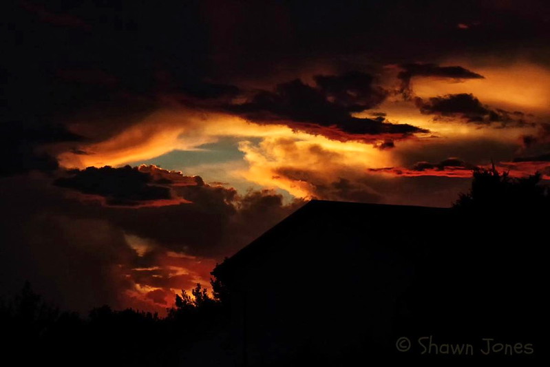
June 5, 2016 – A stunning Thornton sunset. (Shawn Jones)
The month of June typically sees springtime severe weather reach its height of activity in northeastern Colorado.
This affords the opportunity to capture extraordinary images of amazing weather phenomena from monstrous supercell thunderstorms to heavy rain, hail and even tornadoes.
Slideshow updated June 30, 2016
Showcasing images captured by ThorntonWeather.com readers as well as some of our own, our monthly slideshow covers the entire gamut of weather and nature related imagery.
Sunsets, sunrises, wildlife and of course every type of weather condition are vividly depicted. June brings some very dynamic weather and the photos are a great way to see the stunning variety.
To learn more about how to send your photo to us for inclusion in the slideshow, see below the slideshow.
[flickr_set id=”72157668976345302″]
What is missing in the slideshow above? Your photo!
Our monthly photo slideshow is going to feature images that we have taken but more importantly images that you have captured. The photos can be of anything even remotely weather-related.
Landscapes, current conditions, wildlife, pets, kids. Whimsical, newsy, artsy. Taken at the zoo, some other area attraction, a local park, a national park or your backyard. You name it, we want to see and share it!
Images can be taken in Thornton, Denver or anywhere across the extraordinary Centennial State. We’ll even take some from out of state if we can tie it to Colorado somehow.
We’ll keep the criteria very open to interpretation with just about any image eligible to be shown in our slideshows.
What do you win for having your image in our slideshow? We are just a ‘mom and pop’ outfit and make no money from our site so we really don’t have the means to provide prizes. However you will have our undying gratitude and the satisfaction that your images are shared on the most popular website in Thornton.
To share you images with us and get them included in the slideshow just email them to us or share them with ThorntonWeather.com on any of the various social media outlets. Links are provided below.
Thornton, Colorado monthly and seasonal snowfall totals from the 2006 / 2007 season to the the 2015 / 2016 season. Click for larger view. (ThorntonWeather.com)
To say we had a lot of snow this past season would be a bit of an understatement. Our total came in at more than 2 feet higher than historical average for Thornton and Denver.
In all, Thornton received 85.7 inches of snowfall for the 2015 / 2016 season. That total eclipses the 10-year Thornton average of 58.0 inches and Denver’s official 30-year average (1981 – 2010) of 55.3 inches.
The measurement is also Thornton’s highest snowfall total of the past 10 years since ThorntonWeather.com came into existence. The next highest seasonal total is the 72.9 inches received during the 2006 / 2007 season.
Thornton saw five months with above normal snowfall. Most notable was November which received nearly 10 inches more than normal and March with 18.9 inches more than average.
Denver’s official seasonal total was well above normal as well. Out at Denver International Airport where the measurements are taken, The National Weather Service reported 72.8 inches.
It is likely if the Mile High City’s measurements were still done at a location in the city, the total would have been a good bit higher.
Thornton saw overall weather conditions not too far out of line with what we expect for the month of May. Temperatures were a good bit below normal however while precipitation came in right near average.
The month started out a bit chilly and we received our first and only snow for the month on the first. Warmer weather returned right away though and lasted until the 7th of the month when severe weather arrived to the Colorado plains. Tornadoes and large hail were seen to our east and northeast but we received only a bit of rain and some small hail.
Cooler weather conditions lasted for a few days before we warmed up for two days on the 12th and 13th. That was short-lived however and once again things cooled down quite a bit with the 16th and 17th of the month seeing high temperatures only in the mid to upper 40s and a healthy shot of rain.
The final 11 days of the month saw temperatures near or above normal for the most part. Stormy weather returned on the 24th as afternoon thunderstorms brought marble sized hail to Thornton. Eastern Adams County and Washington County saw tornadoes and large, damaging hail. Six of those last 11 days of the month did bring measurable precipitation.
Thornton saw a monthly average temperature of 54.2 degrees. This was well below Denver’s 30 year average for the month of May of 57.1 degrees. Out at DIA where Denver’s official measurements are taken, the Mile High City was similarly cool with a monthly average of 54.4 degrees.
Temperatures in Thornton ranged from a high of 85.6 degrees on the 21st down to a below freezing low of 24.9 degrees on the 2nd. Out at the airport, the warmest reading was 83 degrees and the lowest 28 degrees, both on the same dates as our warmest / coldest temperatures.
In terms of precipitation, Denver averages 2.12 inches during the month of May. Thornton saw 2.07 inches in our rain bucket while DIA recorded 2.38 inches.
The only snow during May 2016 in Thornton came on the first of the month when 0.3 inches fell. Denver officially recorded only a trace. Average snowfall for the month of May in Denver is 1.1 inches.
May 2016 temperature summary for Thornton, Colorado. (ThorntonWeather.com)May 2016 precipitation summary for Thornton, Colorado. (ThorntonWeather.com)
From the National Weather Service:
CLIMATE REPORT
NATIONAL WEATHER SERVICE DENVER/BOULDER CO
244 AM MDT WED JUN 1 2016

...THE DENVER CO CLIMATE SUMMARY FOR THE MONTH OF MAY 2016...

CLIMATE NORMAL PERIOD 1981 TO 2010
CLIMATE RECORD PERIOD 1872 TO 2016

WEATHER         OBSERVED          NORMAL  DEPART  LAST YEAR`S
                 VALUE   DATE(S)  VALUE   FROM    VALUE  DATE(S)
                                          NORMAL
................................................................
TEMPERATURE (F)
RECORD
 HIGH              95   05/26/1942
 LOW               19   05/02/2013
                        05/03/1907
                        01/01/2000
HIGHEST            83   05/21        95     -12       85  05/31
LOWEST             28   05/02        19       9       27  05/10
                                                          05/09
AVG. MAXIMUM     66.9              71.5    -4.6     63.3
AVG. MINIMUM     41.9              42.7    -0.8     42.7
MEAN             54.4              57.1    -2.7     53.0
DAYS MAX >= 90      0               0.8    -0.8        0
DAYS MAX <= 32      0               0.0     0.0        0
DAYS MIN <= 32      3               1.9     1.1        3
DAYS MIN <= 0       0               0.0     0.0        0

PRECIPITATION (INCHES)
RECORD
 MAXIMUM         8.57   1876
 MINIMUM         0.06   1974
TOTALS           2.38              2.12    0.26     3.76
DAILY AVG.       0.08              0.07    0.01     0.12
DAYS >= .01        13               9.4     3.6       19
DAYS >= .10         4               4.8    -0.8       10
DAYS >= .50         1               1.2    -0.2        2
DAYS >= 1.00        1               0.2     0.8        1
GREATEST
 24 HR. TOTAL    1.38   05/26 TO 05/27           05/08 TO 05/09
                                                          05/09 TO 05/09
SNOWFALL (INCHES)
RECORDS
 TOTAL             MM   MM
TOTALS              T               1.1

DEGREE_DAYS
HEATING TOTAL     326               265      61      367
 SINCE 7/1       5556              5996    -440     5572
COOLING TOTAL       3                21     -18        4
 SINCE 1/1          3                22     -19        4

FREEZE DATES
RECORD
 EARLIEST     09/08/1962
 LATEST       06/08/2007
EARLIEST                        10/07
LATEST                          05/05
..........................................................

WIND (MPH)
AVERAGE WIND SPEED              10.2
RESULTANT WIND SPEED/DIRECTION   2/154
HIGHEST WIND SPEED/DIRECTION    39/200    DATE  05/08
HIGHEST GUST SPEED/DIRECTION    47/300    DATE  05/29

SKY COVER
POSSIBLE SUNSHINE (PERCENT)   MM
AVERAGE SKY COVER           0.60
NUMBER OF DAYS FAIR            4
NUMBER OF DAYS PC             18
NUMBER OF DAYS CLOUDY          9

AVERAGE RH (PERCENT)     60

WEATHER CONDITIONS. NUMBER OF DAYS WITH
THUNDERSTORM             13     MIXED PRECIP               0
HEAVY RAIN                1     RAIN                       5
LIGHT RAIN               17     FREEZING RAIN              0
LT FREEZING RAIN          0     HAIL                       2
HEAVY SNOW                0     SNOW                       1
LIGHT SNOW                1     SLEET                      0
FOG                      10     FOG W/VIS <= 1/4 MILE      2
HAZE                      3

-  INDICATES NEGATIVE NUMBERS.
R  INDICATES RECORD WAS SET OR TIED.
MM INDICATES DATA IS MISSING.
T  INDICATES TRACE AMOUNT.
Springtime means not only is the weather active, so too is the wildlife. Great Horned Owl owlets in Thornton. (Shannon Dizmang)
Colorado’s famously highly variable weather seems to showcase itself during the month of May when a variety of weather conditions can be seen. This provides a prime opportunity for photos of everything weather to flora to fauna.
The month of May can bring extremes. Snow is not entirely uncommon during the month but more common is severe weather, particularly in the latter half of the month. Thunderstorms become more frequent and their associated hazards – lightning, wind, hail and tornadoes – are usual visitors. Providing additional subjects for pictures are the emerging spring flowers and our abundant wildlife.
Slideshow updated May 31, 2016. To learn more about how to send your photo to us for inclusion in the slideshow, see below the slideshow.
Showcasing images captured by ThorntonWeather.com readers as well as some of our own, our monthly slideshow covers the entire gamut of weather-related imagery.
Sunsets, sunrises, wildlife and of course every type of weather condition are vividly depicted in images captured from yours and our cameras.
[flickr_set id=”72157667503622900″]
What is missing in the slideshow above? Your photo!
Our monthly photo slideshow is going to feature images that we have taken but more importantly images that you have captured. The photos can be of anything even remotely weather-related.
Landscapes, current conditions, wildlife, pets, kids. Whimsical, newsy, artsy. Taken at the zoo, some other area attraction, a local park, a national park or your backyard. You name it, we want to see and share it!
Images can be taken in Thornton, Denver or anywhere across the extraordinary Centennial State. We’ll even take some from out of state if we can tie it to Colorado somehow.
We’ll keep the criteria very open to interpretation with just about any image eligible to be shown in our slideshows.
What do you win for having your image in our slideshow? We are just a ‘mom and pop’ outfit and make no money from our site so we really don’t have the means to provide prizes. However you will have our undying gratitude and the satisfaction that your images are shared on the most popular website in Thornton.
To share you images with us and get them included in the slideshow just email them to us or share them with ThorntonWeather.com on any of the various social media outlets. Links are provided below.
Colorado’s famously highly variable weather seems to showcase itself during the month of May when a variety of weather conditions can be seen.
Winter-like temperatures and snow are possible as are mid-summer like temperatures or the more typical spring severe weather.
As the month starts out in 2016 we see snow but then warmer, milder weather is expected to arrive for the balance of the first week of the month. Long range forecasts lean toward overall cooler and wetter than normal conditions.
However the month can bring extremes. Snow is not entirely uncommon during the month, oftentimes causing damage to newly bloomed trees. More common however is severe weather, particularly in the latter half of the month. Thunderstorms become more frequent and their associated hazards – lightning, wind, hail and tornadoes – are usual visitors.
Coming off a very snowy and cold March, Thornton saw a relatively seasonal April 2016. Temperatures were right near normal but we did see a healthier than average dose of snow and precipitation.
The month started out quite mild. In fact 13 of the first 14 days saw above average high temperatures. That changed quickly though at the middle of the month when a storm system brought cold and snow to the Front Range. While most of the white stuff fell to our south, Thornton managed respectable totals over the 16th and 17th of the month.
We then returned to mild weather but only for a few days as a series of low pressure systems passed through the state. The final three days of the month saw well-below average high temperatures and periods of rain and snow.
Thornton saw an average temperature for the month of 48.0 degrees. Out at the airport where Denver’s official measurements are kept, the monthly average was a bit cooler at 47.2 degrees. Both were quite close to the April long term average of 47.4 degrees.
Temperatures in Thornton ranged from a maximum of 78.3 degrees on the 22nd down to a low of 21.9 degrees on the first of the month. DIA saw a maximum of 77 degrees on the 22nd and 23rd and a low of 25 degrees on the first.
In terms of precipitation, Denver’s long term April average is 1.71 inches. On this front, both Thornton and Denver came out above normal. We saw 2.47 inches of liquid precipitation in our bucket in Thornton while Denver recorded 2.56 inches.
Snowfall was above the 8.9 inch April average in Thornton and Denver. Thornton however only bested it by a half inch with a total of 9.4 inches for the month. Out at the airport, 15.6 inches was recorded.
Thornton, Colorado’s April 2016 temperature summary. (ThorntonWeather.com)Thornton, Colorado’s April 2016 precipitation summary. (ThorntonWeather.com)
CLIMATE REPORT
NATIONAL WEATHER SERVICE DENVER/BOULDER CO
244 AM MDT SUN MAY 1 2016

...THE DENVER CO CLIMATE SUMMARY FOR THE MONTH OF APRIL 2016...

CLIMATE NORMAL PERIOD 1981 TO 2010
CLIMATE RECORD PERIOD 1872 TO 2016

WEATHER         OBSERVED          NORMAL  DEPART  LAST YEAR`S
                 VALUE   DATE(S)  VALUE   FROM    VALUE  DATE(S)
                                          NORMAL
................................................................
TEMPERATURE (F)
RECORD
 HIGH              90   04/30/1992
 LOW               -2   04/02/1975
HIGHEST            77   04/23        90     -13       79  04/30
                        04/22
                        04/14
LOWEST             25   04/01        -2      27       27  04/03
AVG. MAXIMUM     59.4              61.5    -2.1     62.1
AVG. MINIMUM     35.1              33.3     1.8     35.3
MEAN             47.2              47.4    -0.2     48.7
DAYS MAX >= 90      0               0.0     0.0        0
DAYS MAX <= 32      0               0.3    -0.3        0
DAYS MIN <= 32     11              13.0    -2.0        7
DAYS MIN <= 0 0 0.0 0.0 0 PRECIPITATION (INCHES) RECORD MAXIMUM 8.24 1900 MINIMUM 0.03 1963 TOTALS 2.56 1.71 0.85 2.65 DAILY AVG. 0.09 0.06 0.03 0.09 DAYS >= .01        10               9.1     0.9        9
DAYS >= .10         6               4.5     1.5        6
DAYS >= .50         2               0.9     1.1        2
DAYS >= 1.00        1               0.5     0.5        1
GREATEST
 24 HR. TOTAL    1.22   04/15 TO 04/16           04/16 TO 04/17
                                                          04/17 TO 04/17
                                                          04/17 TO 04/17
 STORM TOTAL       MM                                 MM
 (MM/DD(HH))            MM                    04/17(00) TO 04/17(00)
                                                 04/17(00) TO 04/17(00)7
                                                 04/17(00) TO 04/17(00)7

SNOWFALL (INCHES)
TOTALS           15.6               8.9    6.7

DEGREE_DAYS
HEATING TOTAL     526               529      -3      481
 SINCE 7/1       5230              5731    -501     5205
COOLING TOTAL       0                 1      -1        0
 SINCE 1/1          0                 1      -1        0

FREEZE DATES
RECORD
 EARLIEST     09/08/1962
 LATEST       06/08/2007
EARLIEST      04/01             10/07
LATEST                          05/05
........................................................

WIND (MPH)
AVERAGE WIND SPEED              10.9
RESULTANT WIND SPEED/DIRECTION   2/243
HIGHEST WIND SPEED/DIRECTION    43/300    DATE  04/05
HIGHEST GUST SPEED/DIRECTION    53/300    DATE  04/05

SKY COVER
POSSIBLE SUNSHINE (PERCENT)   MM
AVERAGE SKY COVER           0.60
NUMBER OF DAYS FAIR            6
NUMBER OF DAYS PC             15
NUMBER OF DAYS CLOUDY          9

AVERAGE RH (PERCENT)     55

WEATHER CONDITIONS. NUMBER OF DAYS WITH
THUNDERSTORM              0     MIXED PRECIP               0
HEAVY RAIN                0     RAIN                       2
LIGHT RAIN                6     FREEZING RAIN              0
LT FREEZING RAIN          0     HAIL                       0
HEAVY SNOW                1     SNOW                       5
LIGHT SNOW                8     SLEET                      0
FOG                       9     FOG W/VIS <= 1/4 MILE      4
HAZE                      1

-  INDICATES NEGATIVE NUMBERS.
R  INDICATES RECORD WAS SET OR TIED.
MM INDICATES DATA IS MISSING.
T  INDICATES TRACE AMOUNT.
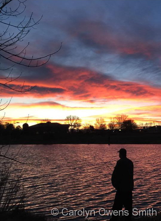
A picture perfect evening in Adams County. (Carolyn Owens Smith)
April can be a tricky month weather-wise with everything from mild temperatures to snow to severe weather being possible. The good thing about that is that it provides plenty of chances for great photos!
April marks a transition between winter and summer for most of the country but for Denver it is especially true as we can see a stunning variety of weather.
The proverbial April showers are certainly a possibility for Denver. Snow? Tornadoes? Thunderstorms? You bet – all can happen!
Throw in our usual wildlife plus the wide variety of birds that return to the Centennial State for the spring and summer and there is a lot going on.
Slideshow updated April 23, 2016.
To learn more about how to send your photo to us for inclusion in the slideshow, see below the slideshow.
Showcasing images captured by ThorntonWeather.com readers as well as some of our own, our monthly slideshow covers the entire gamut of weather-related imagery.
Sunsets, sunrises, wildlife and of course every type of weather condition are vividly depicted in images captured from yours and our cameras.
[flickr_set id=”72157666986103395″]
What is missing in the slideshow above? Your photo!
Our monthly photo slideshow is going to feature images that we have taken but more importantly images that you have captured. The photos can be of anything even remotely weather-related.
Landscapes, current conditions, wildlife, pets, kids. Whimsical, newsy, artsy. Taken at the zoo, some other area attraction, a local park, a national park or your backyard. You name it, we want to see and share it!
Images can be taken in Thornton, Denver or anywhere across the extraordinary Centennial State. We’ll even take some from out of state if we can tie it to Colorado somehow.
We’ll keep the criteria very open to interpretation with just about any image eligible to be shown in our slideshows.
What do you win for having your image in our slideshow? We are just a ‘mom and pop’ outfit and make no money from our site so we really don’t have the means to provide prizes. However you will have our undying gratitude and the satisfaction that your images are shared on the most popular website in Thornton.
To share you images with us and get them included in the slideshow just email them to us or share them with ThorntonWeather.com on any of the various social media outlets. Links are provided below.
We will enjoy one mild day this week and today is it. After this, it goes downhill with unsettled, cooler conditions for the balance.
Today starts out with mostly sunny skies and calm, mild conditions. Temperatures will be climbing to a high of around 73 degrees, a good bit above the average for the date of 64 degrees.
Winds will be a bit breezy this afternoon and the latter part of the afternoon and into the evening brings a chance for showers and thunderstorms. Right now we expect most of these storms to be high-based and bring primarily wind.
Looking ahead, low pressure is going to reign for the balance of the workweek and through the weekend. Temperatures are going to generally be about 10 degrees below normal and each day will feature opportunities for showers, maybe even just a touch of snow even early tomorrow morning and Wednesday morning. Get a complete look at the extended weather forecast here.
Mother Nature played a somewhat cruel trick on the Colorado Front Range. The week started with mild temperatures and a definite feeling of spring in the air. She closed out the week with a significant snowstorm and plenty of cold.
The long-expected storm arrived on the evening of Friday the 15th with rain. Overnight into the early morning of the 16th, the rain continued, heavy at times. In the early morning hours, as temperatures dropped, the rain changed to snow and would continue virtually non-stop through the morning of the 17th.
Thornton’s snowfall totals were certainly at the lower end of what was reported in the Denver metro area. We saw 7.3 inches, much of which melted as fast as it fell. Other locations not far to the west and south were pushing a foot and locations in the foothills and Palmer Divide saw nearly two feet.
The time lapse video begins at midnight on the morning of the 16th and continues through noon on the 17th.
Weather, natural disasters & climate news and information.