Whew! Is this September or July? As expected the mercury kept on climbing today and did indeed get into record-setting territory.
At 1:53pm the temperature at Denver International Airport where the Mile High City’s official records are kept reached 97 degrees. This easily bests the previous record high for the date of 95 degrees set in 1995.
Additionally the reading tied the record for hottest September temperature. Six other times in the past the mercury reached 97 degrees during September occurring on September 1, 1995, September 4, 1960, September 4, 1995, September 5, 1899, September 5, 2013, and September 6, 2013.
Here in Thornton, we were actually warmer than DIA (a rarity). Temperatures here topped out at 98.5 degrees at 1:20pm.
While above normal temperatures (but not record-setting) are expected for tomorrow, we do expect to see a significant cool down Tuesday then see things bounce back to readings a bit above normal for the balance of the week. See the extended forecast here.
Following on what was a cool but dry August, some are certainly hoping for a bit of precipitation. The month can bring plenty of rain and even our first snow of the season but more often than not, it is one of the most pleasant along the Colorado Front Range.
As temperatures start to drop, September usually reminds us that summer is at an end and fall is now here. Sunshine is predominant though as the month actually has the highest percentage of sun out of any month. Sunny days and clear, cool nights are the standard weather pattern for the month.
The month can bring extremes however. We will of course forever remember 2013’s devastating floods brought on by record-setting rain. Longtime residents might remember September 1971 which brought over 17 inches of snowfall.
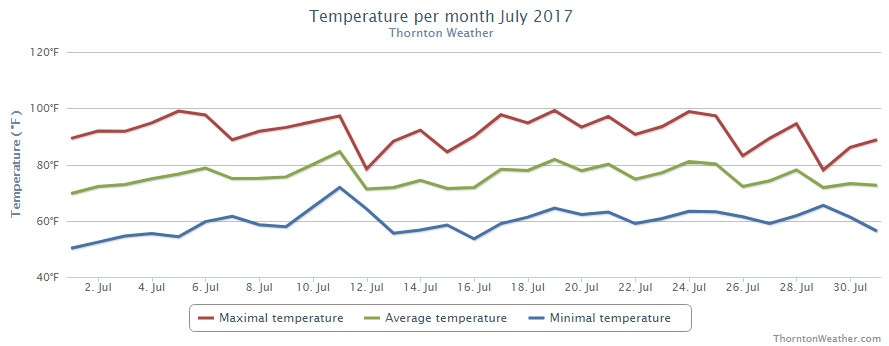
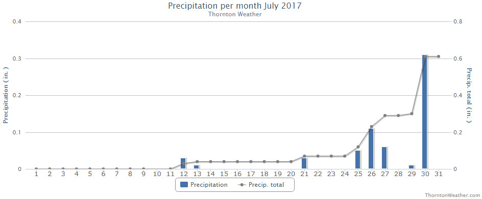
The month of July might have seemed quite hot but in fact mercury readings were right near normal. What likely caused the misconception is the fact that we saw far less than normal rain.
High pressure did dominate for much of the month and while monsoonal flow did bring rain to eastern Colorado, it largely missed our area. The Palmer Divide and southeastern Colorado were beneficiaries for much of the month but for us it wasn’t until the last week that we saw relief.
Thornton’s average temperature for the month came in at 74.1 degrees. This is almost exactly matches Denver’s long-term July average of 74.2 degrees. Out at DIA where the Mile High City’s official temperatures are taken, it shows a far warmer month with an average of 76.4 degrees.
Temperatures here ranged from a maximum of 99.2 degrees on the 19th down to a low of 50.1 degrees on the morning of the 1st. Out at the airport, their highest reading was actually 100 degrees seen on the 6th and again on the 19th. The low out there was 51 degrees on the 1st.
On average Denver receives 2.16 inches of precipitation during July. Both Thornton and Denver fell far short of that mark. We managed to record 0.61 inches in our bucket during the month, more than half of which fell on the second to last day of the month. At DIA, Denver recorded 0.47 inches.
Thornton, Colorado’s July 2017 temperature summary. (ThorntonWeather.com)Thornton, Colorado’s July 2017 precipitation summary. (ThorntonWeather.com)
From the National Weather Service:
CLIMATE REPORT
NATIONAL WEATHER SERVICE DENVER/BOULDER CO
656 AM MDT TUE AUG 1 2017

...................................

...THE DENVER CO CLIMATE SUMMARY FOR THE MONTH OF JULY 2017...

CLIMATE NORMAL PERIOD 1981 TO 2010
CLIMATE RECORD PERIOD 1872 TO 2017

WEATHER         OBSERVED          NORMAL  DEPART  LAST YEAR`S
                 VALUE   DATE(S)  VALUE   FROM    VALUE  DATE(S)
                                          NORMAL
................................................................
TEMPERATURE (F)
RECORD
 HIGH             105   07/20/2005
 LOW               42   07/04/1903
                        07/31/1873
HIGHEST           100   07/19        99      -5      102  07/10
                        07/06
LOWEST             51   07/01        51       9       51  07/12
AVG. MAXIMUM     91.5              89.4     2.1     92.0
AVG. MINIMUM     61.3              58.9     2.4     60.5
MEAN             76.4              74.2     2.2     76.2
DAYS MAX >= 90     20              16.0     4.0       22
DAYS MAX <= 32      0               0.0     0.0        0
DAYS MIN <= 32      0               0.0     0.0        0
DAYS MIN <= 0 0 0.0 0.0 0
PRECIPITATION (INCHES)
RECORD
 MAXIMUM 6.41 1965
 MINIMUM 0.01 1901
TOTALS 0.47 2.16 -1.69 1.07
DAILY AVG. 0.02 0.07 -0.05 0.03
DAYS >= .01         6               8.3    -2.3        6
DAYS >= .10         3               4.3    -1.3        4
DAYS >= .50         0               1.4    -1.4        1
DAYS >= 1.00        0               0.7    -0.7        0
GREATEST
 24 HR. TOTAL    0.15   07/21 TO 07/21           07/01 TO 07/01
                                                          06/30 TO 07/01
                                                          07/01 TO 07/01

SNOWFALL (INCHES)
RECORDS TOTAL      0.0
 TOTALS            0.0 2017         0.0

DEGREE_DAYS
HEATING TOTAL       0                 6      -6        0
 SINCE 7/1          0                 6      -6        0
COOLING TOTAL     360               289      71      356
 SINCE 1/1        533               444      89      544

FREEZE DATES
RECORD
 EARLIEST     09/08/1962
 LATEST       06/08/2007
EARLIEST                        10/07
LATEST                          05/05
..................................................

WIND (MPH)
AVERAGE WIND SPEED              9.6
RESULTANT WIND SPEED/DIRECTION   3/204
HIGHEST WIND SPEED/DIRECTION    45/120    DATE  07/15
HIGHEST GUST SPEED/DIRECTION    53/120    DATE  07/15

SKY COVER
POSSIBLE SUNSHINE (PERCENT)   MM
AVERAGE SKY COVER           0.50
NUMBER OF DAYS FAIR            6
NUMBER OF DAYS PC             21
NUMBER OF DAYS CLOUDY          4

AVERAGE RH (PERCENT)     45

WEATHER CONDITIONS. NUMBER OF DAYS WITH
THUNDERSTORM              9     MIXED PRECIP               0
HEAVY RAIN                0     RAIN                       3
LIGHT RAIN                9     FREEZING RAIN              0
LT FREEZING RAIN          0     HAIL                       0
HEAVY SNOW                0     SNOW                       0
LIGHT SNOW                0     SLEET                      0
FOG                       3     FOG W/VIS <= 1/4 MILE      1
HAZE                      3

-  INDICATES NEGATIVE NUMBERS.
R  INDICATES RECORD WAS SET OR TIED.
MM INDICATES DATA IS MISSING.
T  INDICATES TRACE AMOUNT.
As summer vacations wind down and families prepare to send their kids back to school in August, Colorado weather also starts to settle down. The chances for severe weather decrease markedly during August and by the end of the month daytime temperatures are dropping quite a bit as well.
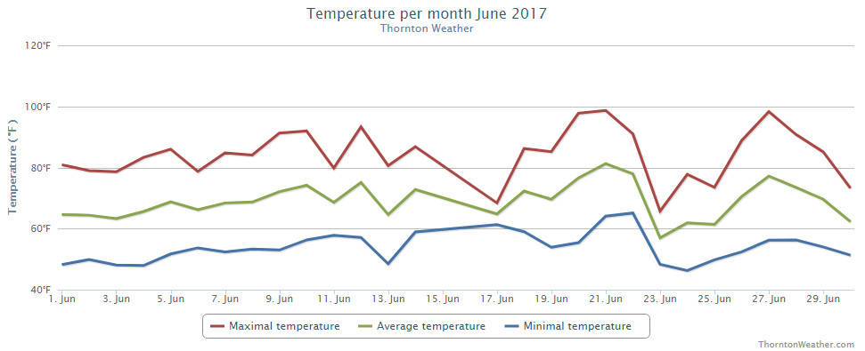
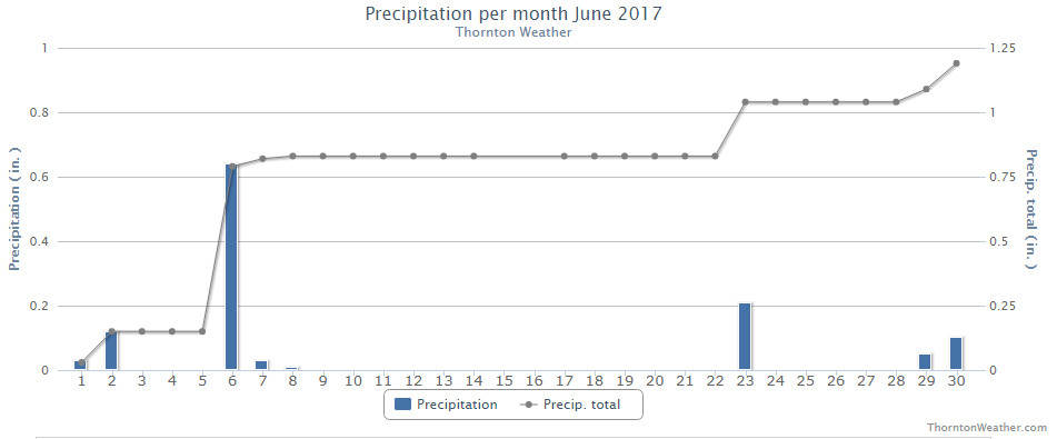
High pressure was the general rule for much of the month of June 2017. This resulted in overall average temperatures that were warmer than normal and precipitation that fell a good ways short of average.
The month was largely short on weather excitement, beyond the temps and lack of precipitation. The National Weather Service said that 23 of the 30 days saw above normal temperature readings. Denver recorded only five days with precipitation while in Thornton we saw eight.
Thornton saw an overall average monthly temperature of 69.2 degrees. Out at DIA where Denver’s official measurements are taken, the Mile High City was close with an average of 69.5 degrees. Both locations’ readings were well above the long term June average of 67.4 degrees.
Temperatures in Thornton ranged from a high of 98.7 degrees on the 21st down to a low of 46.3 degrees on the morning of the 24th. Denver saw a maximum of 99 degrees on the 20th and a low of 42 degrees on the 13th.
In terms of precipitation, Denver averages 1.98 inches during the month of June. Thornton fell short of the mark with 1.20 inches falling into our rain bucket while Denver’s reading was far worse with a mere 0.33 inches falling there.
Neither Thornton nor Denver saw any snowfall during the month.
Thornton, Colorado’s June 2017 temperature summary. (ThorntonWeather.com)Thornton, Colorado’s June 2017 precipitation summary. (ThorntonWeather.com)
From the National Weather Service:
CLIMATE REPORT
NATIONAL WEATHER SERVICE DENVER/BOULDER CO
729 AM MDT SAT JUL 1 2017

...................................

...THE DENVER CO CLIMATE SUMMARY FOR THE MONTH OF JUNE 2017...

CLIMATE NORMAL PERIOD 1981 TO 2010
CLIMATE RECORD PERIOD 1872 TO 2017

WEATHER         OBSERVED          NORMAL  DEPART  LAST YEAR`S
                 VALUE   DATE(S)  VALUE   FROM    VALUE  DATE(S)
                                          NORMAL
................................................................
TEMPERATURE (F)
RECORD
 HIGH             105   06/26/2012
                        06/25/2012
  LOW              30   06/02/1951

HIGHEST            99   06/20        96       3       98  06/21
LOWEST             42   06/13        42       0       49  06/02
AVG. MAXIMUM     85.5              82.4     3.1     85.5
AVG. MINIMUM     53.6              52.3     1.3     56.2
MEAN             69.5              67.4     2.1     70.8
DAYS MAX >= 90      9               7.9     1.1       12
DAYS MAX <= 32      0               0.0     0.0        0
DAYS MIN <= 32      0               0.0     0.0        0
DAYS MIN <= 0 0 0.0 0.0 0
PRECIPITATION (INCHES)
RECORD
 MAXIMUM 4.96 1882
 MINIMUM T 1890
TOTALS 0.33 1.98 -1.65 1.62
DAILY AVG. 0.01 0.07 -0.06 0.05
DAYS >= .01         5               8.4    -3.4        7
DAYS >= .10         2               4.6    -2.6        4
DAYS >= .50         0               1.4    -1.4        1
DAYS >= 1.00        0               0.3    -0.3        0
GREATEST
 24 HR. TOTAL    0.13   06/29 TO 06/29           06/13 TO 06/13

SNOWFALL (INCHES)
RECORD            0.5 1953
 TOTAL            0.0 2017          0.0

DEGREE_DAYS
HEATING TOTAL      25                62     -37        4
 SINCE 7/1       5109              6058    -949     5560
COOLING TOTAL     167               133      34      185
 SINCE 1/1        173               155      18      188

FREEZE DATES
RECORD
 EARLIEST     09/08/1962
 LATEST       06/08/2007
EARLIEST      04/01             10/07
LATEST        05/04             05/05
....................................................

WIND (MPH)
AVERAGE WIND SPEED              10.1
RESULTANT WIND SPEED/DIRECTION   2/135
HIGHEST WIND SPEED/DIRECTION    44/270    DATE  06/27
HIGHEST GUST SPEED/DIRECTION    66/270    DATE  06/27

SKY COVER
POSSIBLE SUNSHINE (PERCENT)   MM
AVERAGE SKY COVER           0.50
NUMBER OF DAYS FAIR            6
NUMBER OF DAYS PC             22
NUMBER OF DAYS CLOUDY          2

AVERAGE RH (PERCENT)     47

WEATHER CONDITIONS. NUMBER OF DAYS WITH
THUNDERSTORM             10     MIXED PRECIP               0
HEAVY RAIN                2     RAIN                       2
LIGHT RAIN                8     FREEZING RAIN              0
LT FREEZING RAIN          0     HAIL                       0
HEAVY SNOW                0     SNOW                       0
LIGHT SNOW                0     SLEET                      0
FOG                       3     FOG W/VIS <= 1/4 MILE      0
HAZE                      1

-  INDICATES NEGATIVE NUMBERS.
R  INDICATES RECORD WAS SET OR TIED.
MM INDICATES DATA IS MISSING.
T  INDICATES TRACE AMOUNT.
Hail pounds north Denver in our first severe weather of the season on May 8, 2017. (Ed Dalton)
Colorado’s famously highly variable weather seems to showcase itself during the month of May when a variety of weather conditions can be seen. This provides a prime opportunity for photos of everything weather to flora to fauna.
The month of May can bring extremes. Snow is not entirely uncommon during the month but more common is severe weather, particularly in the latter half of the month. Thunderstorms become more frequent and their associated hazards – lightning, wind, hail and tornadoes – are usual visitors. Providing additional subjects for pictures are the emerging spring flowers and our abundant wildlife.
Slideshow updated June 1, 2017. To learn more about how to send your photo to us for inclusion in the slideshow, see below the slideshow.
Showcasing images captured by ThorntonWeather.com readers as well as some of our own, our monthly slideshow covers the entire gamut of weather-related imagery.
Sunsets, sunrises, wildlife and of course every type of weather condition are vividly depicted in images captured from yours and our cameras.
[flickr_set id=”72157683626294335″]
What is missing in the slideshow above? Your photo!
Our monthly photo slideshow is going to feature images that we have taken but more importantly images that you have captured. The photos can be of anything even remotely weather-related.
Landscapes, current conditions, wildlife, pets, kids. Whimsical, newsy, artsy. Taken at the zoo, some other area attraction, a local park, a national park or your backyard. You name it, we want to see and share it!
Images can be taken in Thornton, Denver or anywhere across the extraordinary Centennial State. We’ll even take some from out of state if we can tie it to Colorado somehow.
We’ll keep the criteria very open to interpretation with just about any image eligible to be shown in our slideshows.
What do you win for having your image in our slideshow? We are just a ‘mom and pop’ outfit and make no money from our site so we really don’t have the means to provide prizes. However you will have our undying gratitude and the satisfaction that your images are shared on the most popular website in Thornton.
To share you images with us and get them included in the slideshow just email them to us or share them with ThorntonWeather.com on any of the various social media outlets. Links are provided below.
The month of April had a bit of a mixed bag for Thornton. While we saw temperatures above normal and snowfall below normal, precipitation actually ended up right near Denver’s long term average.
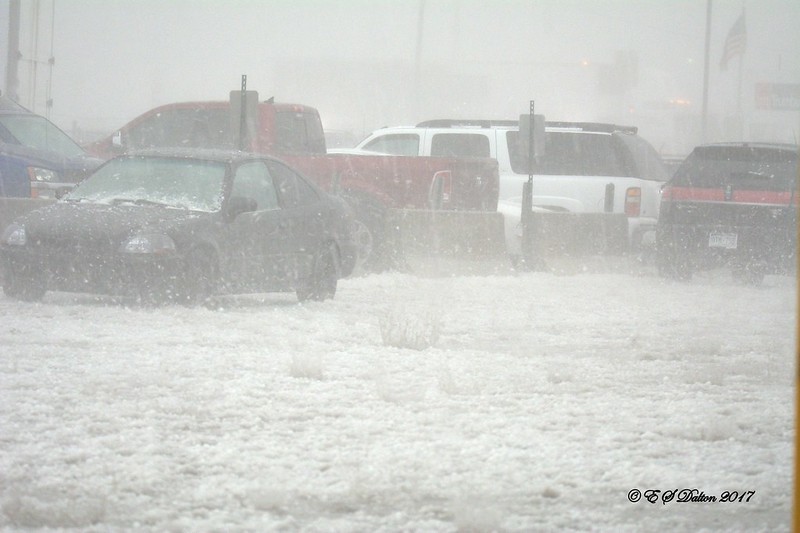
We started out cool on the first day of the month, warmed up for two days, then were delivered our first snowfall of the month on the fourth day. From there we saw a string of above normal temperatures, some far above, that lasted almost uninterrupted for two weeks.
Some rain finally fell for the three days beginning the 20th and temperatures cooled a bit. Then, on the 28th, we received our second and final snowfall of the month and followed it up with a very cold day before rebounding on the final day of the month.
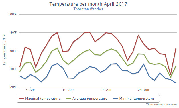
Thornton saw an average temperature during April 2017 of 49.6 degrees. This was a good ways above Denver’s long term average for the month of 47.4 degrees. Out at the airport, they were cooler with an average of 48.9 degrees.
Thornton’s temperatures ranged from a maximum of 80.3 degrees on the 14th down to a low of 24.1 degrees on the morning of the 30th. Denver saw similar extremes of 79 degrees, also on the 14th, and a low of 24 degrees on the 10th.
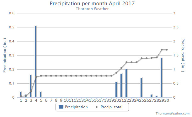
In terms of precipitation, Denver averages 1.71 inches during April. Thornton was right there with the average at 1.70 inches in our rain bucket. At DIA, things were quite a bit drier with only 0.98 inches being recorded.
Snowfall lagged behind average for the month, especially at the average. Denver recorded only 2.5 inches officially while here in Thornton we came in at 5.8 inches. Once again this highlights the problems with having Denver’s official measurements kept so far from where they were taken historically and far away from population.
Thornton, Colorado temperature summary for April 2017. (ThorntonWeather.com)Thornton, Colorado precipitation summary for April 2017. (ThorntonWeather.com)
From the National Weather Service:
CLIMATE REPORT
NATIONAL WEATHER SERVICE DENVER/BOULDER CO
244 AM MDT MON MAY 1 2017

...................................

...THE DENVER CO CLIMATE SUMMARY FOR THE MONTH OF APRIL 2017...

CLIMATE NORMAL PERIOD 1981 TO 2010
CLIMATE RECORD PERIOD 1872 TO 2017

WEATHER         OBSERVED          NORMAL  DEPART  LAST YEAR`S
                 VALUE   DATE(S)  VALUE   FROM    VALUE  DATE(S)
                                          NORMAL
................................................................
TEMPERATURE (F)
RECORD
 HIGH              90   04/30/1992
 LOW               -2   04/02/1975
HIGHEST            79   04/14        90     -11       77  04/23
                        04/13                             04/22
                                                          04/14
LOWEST             24   04/10        -2      26       25  04/01
AVG. MAXIMUM     63.2              61.5     1.7     59.4
AVG. MINIMUM     34.5              33.3     1.2     35.1
MEAN             48.9              47.4     1.5     47.2
DAYS MAX >= 90      0               0.0     0.0        0
DAYS MAX <= 32      1               0.3     0.7        0
DAYS MIN <= 32     15              13.0     2.0       11
DAYS MIN <= 0 0 0.0 0.0 0
PRECIPITATION (INCHES)
RECORD
 MAXIMUM 8.24 1900
 MINIMUM 0.03 1963
TOTALS 0.98 1.71 -0.73 2.56
DAILY AVG. 0.03 0.06 -0.03 0.09
DAYS >= .01        10               9.1     0.9       10
DAYS >= .10         5               4.5     0.5        6
DAYS >= .50         0               0.9    -0.9        2
DAYS >= 1.00        0               0.5    -0.5        1
GREATEST
 24 HR. TOTAL    0.22   04/29 TO 04/29           04/15 TO 04/16
                                                          04/16 TO 04/16
                                                          04/16 TO 04/16
 STORM TOTAL       MM                                 MM
 (MM/DD(HH))            MM                    04/16(00) TO 04/16(00)
                                                 04/16(00) TO 04/16(00)6
                                                 04/16(00) TO 04/16(00)6

SNOWFALL (INCHES)
RECORDS
 TOTAL             MM   MM
TOTALS            2.5               6.8

DEGREE_DAYS
HEATING TOTAL     478               529     -51      526
 SINCE 7/1       4803              5731    -928     5230
COOLING TOTAL       0                 1      -1        0
 SINCE 1/1          0                 1      -1        0

FREEZE DATES
RECORD
 EARLIEST     09/08/1962
 LATEST       06/08/2007
EARLIEST      04/01             10/07
LATEST                          05/05
.......................................................

WIND (MPH)
AVERAGE WIND SPEED              11.6
RESULTANT WIND SPEED/DIRECTION   1/121
HIGHEST WIND SPEED/DIRECTION    44/300    DATE  04/09
HIGHEST GUST SPEED/DIRECTION    56/300    DATE  04/09

SKY COVER
POSSIBLE SUNSHINE (PERCENT)   MM
AVERAGE SKY COVER           0.60
NUMBER OF DAYS FAIR            6
NUMBER OF DAYS PC             17
NUMBER OF DAYS CLOUDY          7

AVERAGE RH (PERCENT)     53

WEATHER CONDITIONS. NUMBER OF DAYS WITH
THUNDERSTORM              0     MIXED PRECIP               0
HEAVY RAIN                1     RAIN                       1
LIGHT RAIN               10     FREEZING RAIN              0
LT FREEZING RAIN          0     HAIL                       0
HEAVY SNOW                1     SNOW                       3
LIGHT SNOW                7     SLEET                      0
FOG                      10     FOG W/VIS <= 1/4 MILE      4
HAZE                      2

-  INDICATES NEGATIVE NUMBERS.
R  INDICATES RECORD WAS SET OR TIED.
MM INDICATES DATA IS MISSING.
T  INDICATES TRACE AMOUNT.
April 30 to May 6: This week in Denver weather history
May can bring a variety of conditions from snow and cold to severe thunderstorms and flooding rains. Looking back at this week in Denver weather history we see where all of those events have made an appearance in our past.
From the National Weather Service:
29-30
In 1964…several weeks of dry weather and windy conditions across the Great Plains to the east caused noticeable suspended dust to invade metro Denver. At Stapleton International Airport east winds gusted to 28 mph and visibility was reduced to 5 miles.
In 1989…a late season snowstorm dropped 2 to 4 inches of snow across metro Denver with 6 to 12 inches in the foothills. Snowfall totaled 3.9 inches at Stapleton International Airport where northeast winds gusted to 23 mph and the greatest snow depth on the ground was 2 inches due to melting.
In 1991…a pacific storm dumped heavy wet snow across metro Denver. The foothills were hit the hardest where snowfall amounts ranged from 16 inches at Evergreen to 5 inches at Idaho Springs. Lower elevations of metro Denver received 5 to 9 inches of snowfall with 5 inches in Boulder and 7.0 inches at Stapleton International Airport where northeast winds gusted to 25 mph. The weight of the snow caused power lines to fall and tree limbs to snap…producing power outages in parts of Denver…Aurora…and Westminster.
In 1999…heavy snow fell overnight in the foothills above 7500 feet elevation. Snowfall totals included: 13 inches near Rollinsville…10 inches near Evergreen…8 inches at Blackhawk and Nederland…and 7 inches at Conifer. Only rain fell across the city with 2.13 inches recorded at Denver International Airport.
29-2
In 1954…a major storm dumped 10.1 inches of snowfall at Stapleton Airport. Most of the snow…7.5 inches…fell on the 29th and 30th. The maximum snow depth on the ground was 5 inches on the 30th due to melting. No strong winds accompanied the storm.
30
In 1896…northwest winds were sustained to 55 mph with gusts as high as 64 mph in the city.
In 1960…the minimum temperature dipped to 22 degrees at Stapleton Airport. The sub-freezing cold damaged fruit trees and some other crops in the area.
In 1967…west winds gusted to 51 mph at Stapleton International Airport. Winds were strong and gusty across all of metro Denver.
In 1972…hail 1/2 to 3/4 inches in diameter fell at Stapleton International Airport. Northwest winds gusted to 35 mph.
In 1980…a cold air funnel touched down several times near Louisville.
In 1983…mothball-size hail fell in Wheat Ridge.
In 1992…the all-time highest recorded temperature in April… 90 degrees…occurred. This is also the earliest 90 degree reading for the season. In addition…the temperature dipped to a low of only 56 degrees…setting a record high minimum for the date.
In 1995…hail…up to 3/4 inch in diameter…fell at Denver International Airport. The hail was soft…lasted for only 8 to 10 minutes…and caused no damage.
In 2002…drought conditions started to have an effect on greater metro Denver. April…normally the third snowiest month of the year in Denver averaging just over 9 inches of snow…ended with only a trace of snow…ranking the month… Along with previous Aprils…the 2nd least snowiest on record. The month ended with only 0.23 inch of liquid precipitation making the month the 3rd driest on record. Mountain snowpack was less than half of normal for this time of year. A statewide drought emergency was declared by the governor.
In 2003…a small tornado touched down 10 miles east of Hudson… But did no damage. Hail as large as 3/4 inch in diameter fell in Aurora near Cherry Creek.
In 2004…post-frontal upslope flow produced light snowfall across metro Denver. Snowfall was 4.0 inches at Denver Stapleton…while the temperature hovered in the lower 30’s all day. The high temperature was only 33 degrees…a record low maximum for the date. The low temperature of 30 degrees was not a record. North winds gusted to 20 mph at Denver International Airport.
30-1
In 1980…to the west of Denver…heavy rain changing to snow buried the foothills above 7 thousand feet in 4 to 8 inches of snow. Precipitation in the foothills ranged from 1 to 3 inches…which caused some local flooding. Rain fell at lower elevations. Rainfall at Stapleton International Airport totaled 1.05 inches from the storm.
1
In 1902…northwest winds were sustained to 68 mph with gusts as high as 74 mph in the city during the early morning. The apparent very strong Chinook winds warmed the temperature to a high of 78 degrees.
In 1912…south winds were sustained to 42 mph with gusts as high as 58 mph. South to southwest winds were strong all afternoon.
In 1935…a moderate duststorm blew into the city at around 2:00 pm on northwest winds sustained to 17 mph with gusts to 19 mph. Later in the afternoon…the dust receded to the east in advance of a rainstorm from the west.
In 1988…very strong winds behind a vigorous cold front produced a blinding dust storm that closed I-70 east of Denver. Northeast winds over metro Denver peaked to 45 mph at Stapleton International Airport…but only kicked up some blowing dust. The temperature plunged from a high of 76 degrees at midday to 36 degrees at midnight as light rain changed to light snow.
In 1991…3/4 inch diameter hail fell at Standley Lake in northwest metro Denver.
In 1999…heavy snow developed in the foothills above 7 thousand feet elevation. Snow totals included: 10 inches at Rollinsville…7 inches near conifer…and 6 inches atop Crow Hill. Rain fell across metro Denver.
1-2
In 1903…post-frontal rain changed to light snow overnight… But totaled only 2.0 inches. This was the last snow of the season. Northeast winds were sustained to 45 mph with gusts to 48 mph on the 1st.
1-5
In 1898…snowfall totaled 15.5 inches in downtown Denver. Most of the snow…6.2 inches…fell on the 3rd. Most of the snow melted as it fell. The greatest snow depth on the ground was only 2.5 inches on the 3rd at 8:00 pm. This was the only snowfall during the month. Northeast winds were sustained to 22 mph on the 1st.
2
In 1874…strong winds upset two railroad passenger coaches near Georgetown. The baggage was retrieved and placed in a heavy…large wagon. The passengers then seated themselves on top of the baggage. Another strong gust of wind upset the wagon. The driver’s shoulder was dislocated…and a passenger’s leg was badly injured. In Denver…northwest winds increased and blew in gusts and heavy winds were observed on the ridge tops. On the Kansas Pacific R.R. east of Denver…the wind was so strong that it blew the train back several lengths…which caused the train to be about 7 hours late arriving in the city.
In 1901…south winds were sustained to 50 mph with gusts to 60 mph from an apparent thunderstorm with hail.
In 1944…snowfall of 8.3 inches was accompanied by a thunderstorm. This was the last snowfall of the season and the only snow of the month. Northwest winds were sustained to 25 mph.
In 1955…southwest winds at speeds of 37 mph with gusts as high as 58 mph caused some blowing dust at Stapleton Airport.
In 1983…1 inch diameter hail fell a few miles south of Bennett.
In 1984…3/4 inch diameter hail fell in Northglenn.
In 1988…I-70 east of Denver was closed for the second straight day…this time due to snow and blowing snow producing up to 2 foot drifts. While only 2 to 4 inches of snow fell across metro Denver…Strasburg…just east of Denver…received a foot of snow. North winds peaked to 51 mph at Stapleton International Airport where snowfall totaled only 1.3 inches.
In 1995…lightning struck a house in Westminster sparking an attic fire.
2-3
In 1979…heavy rain changed to snow on the 2nd. Snowfall totaled 3.9 inches at Stapleton International Airport… Where northwest winds gusted to 26 mph. The greatest depth of snow on the ground was only 1 inch at midday on the 2nd due to melting. Total precipitation for the 2 days was 1.65 inches.
2-4
In 1987…a slow moving storm brought rain…wind…and snow to metro Denver. Rainfall totaled 1.04 inches at Stapleton International Airport where north winds gusted to 48 mph on the 3rd. The foothills received 5 to 10 inches of snow.
2-5
In 2001…a very slow moving pacific storm system became parked near the four corners region…which allowed heavy snow to develop above 6500 feet in the foothills with a mix of rain and snow over lower elevations of metro Denver. Snowfall totals included: 21 inches atop Crow Hill and at Idaho Springs; 19 inches near Blackhawk; and 18 inches in Coal Creek Canyon…Genesee…and 11 miles southwest of Morrison. Snowfall totaled 6.2 inches at the site of the former Stapleton International Airport. Precipitation (rain and melted snow) totaled 2.09 inches at Denver International Airport where north winds gusted to 30 mph on the 2nd.
3
In 1898…heavy snowfall of 6.2 inches fell over downtown Denver. Most of the snow melted as it fell. The greatest snow depth on the ground was 2.5 inches during the evening.
In 1907…the all-time lowest recorded temperature in the month of May…19 degrees…occurred.
In 1925…an apparent microburst produced sustained northeast winds to 44 mph with gusts to 52 mph. Rainfall was only 0.01 inch in downtown Denver.
In 1981…lightning struck 9 golfers at the south suburban golf course. None were injured seriously.
In 1983…hail 1 1/2 inches in diameter fell at Green Mountain west of Lakewood…with 3/4 inch stones reported in Lakewood.
In 1986…a thunderstorm wind gust to 51 mph was recorded at Stapleton International Airport.
Colorado’s famously highly variable weather seems to showcase itself during the month of May when a variety of weather conditions can be seen.
Winter-like temperatures and snow are possible as are mid-summer like temperatures or the more typical spring severe weather.
As the month starts out in 2017 we see pretty typical conditions with a few cool, possibly damp days, before warming up to above normal levels. Long range forecasts lean toward possibly wetter than normal conditions for the month overall but no overriding factors determining where temperatures will end.
The month can bring extremes. Snow is not entirely uncommon during the month, oftentimes causing damage to newly bloomed trees. More common however is severe weather, particularly in the latter half of the month. Thunderstorms become more frequent and their associated hazards – lightning, wind, hail and tornadoes – are usual visitors.
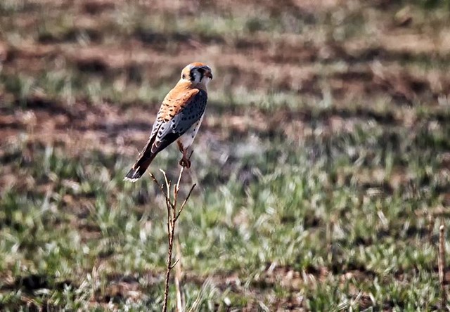
An American Kestrel enjoys a warm, early April day at the Rocky Mountain Arsenal. (Shawn Jones)
April can be a tricky month weather-wise with everything from mild temperatures to snow to severe weather being possible. The good thing about that is that it provides plenty of chances for great photos!
April marks a transition between winter and summer for most of the country but for Denver it is especially true as we can see a stunning variety of weather.
The proverbial April showers are certainly a possibility for Denver. Snow? Tornadoes? Thunderstorms? You bet – all can happen!
Throw in our usual wildlife plus the wide variety of birds that return to the Centennial State for the spring and summer and there is a lot going on.
Slideshow updated April 29, 2017.
To learn more about how to send your photo to us for inclusion in the slideshow, see below the slideshow.
Showcasing images captured by ThorntonWeather.com readers as well as some of our own, our monthly slideshow covers the entire gamut of weather-related imagery.
Sunsets, sunrises, wildlife and of course every type of weather condition are vividly depicted in images captured from yours and our cameras.
[flickr_set id=”72157682120146046″]
What is missing in the slideshow above? Your photo!
Our monthly photo slideshow is going to feature images that we have taken but more importantly images that you have captured. The photos can be of anything even remotely weather-related.
Landscapes, current conditions, wildlife, pets, kids. Whimsical, newsy, artsy. Taken at the zoo, some other area attraction, a local park, a national park or your backyard. You name it, we want to see and share it!
Images can be taken in Thornton, Denver or anywhere across the extraordinary Centennial State. We’ll even take some from out of state if we can tie it to Colorado somehow.
We’ll keep the criteria very open to interpretation with just about any image eligible to be shown in our slideshows.
What do you win for having your image in our slideshow? We are just a ‘mom and pop’ outfit and make no money from our site so we really don’t have the means to provide prizes. However you will have our undying gratitude and the satisfaction that your images are shared on the most popular website in Thornton.
To share you images with us and get them included in the slideshow just email them to us or share them with ThorntonWeather.com on any of the various social media outlets. Links are provided below.
 Whew! Is this September or July? As expected the mercury kept on climbing today and did indeed get into record-setting territory.
 Following on what was a cool but dry August, some are certainly hoping for a bit of precipitation. The month can bring plenty of rain and even our first snow of the season but more often than not, it is one of the most pleasant along the Colorado Front Range.