The weather during the month of November in Denver metro area can offer just about anything. While it is normally a quiet month, it can be prone to extremes.
November has historically been one of Denver’s snowiest months and major snowstorms are not entirely uncommon. However conditions can also be quite dry.
Temperatures during the month continue to cool as we get closer to winter and by the end of the month the low temperatures routinely dip to 20 degrees or below. At times it can in fact bring conditions more like what we see in January.
A gorgeous sunrise as seen at the Rocky Mountain Arsenal kicks off the second day of the month. (Bill Hutchinson)
October in Thornton can bring a wide variety of weather conditions, perfect for the photographer in all of us.
The month brings the changing of the colors at Colorado’s lower elevations and it is also is typically when we see our first freeze and first snow.
Couple those facts with our usual widely varying landscapes and wildlife and we have a month that is sure to bring in plenty of photo opportunities.
Slideshow updated October 31, 2018
To learn more about how to send your photo to us for inclusion in the slideshow, see below the slideshow.
Showcasing images captured by ThorntonWeather.com readers as well as some of our own, our monthly slideshow covers the entire gamut of weather-related imagery.
Sunsets, sunrises, wildlife and of course every type of weather condition are vividly depicted in images captured from yours and our cameras.
[flickr_set id=”72157702277411875″]
What is missing in the slideshow above? Your photo!
Our monthly photo slideshow is going to feature images that we have taken but more importantly images that you have captured. The photos can be of anything even remotely weather-related.
Landscapes, current conditions, wildlife, pets, kids. Whimsical, newsy, artsy. Taken at the zoo, some other area attraction, a local park, a national park or your backyard. You name it, we want to see and share it!
Images can be taken in Thornton, Denver or anywhere across the extraordinary Centennial State. We’ll even take some from out of state if we can tie it to Colorado somehow.
We’ll keep the criteria very open to interpretation with just about any image eligible to be shown in our slideshows.
What do you win for having your image in our slideshow? We are just a ‘mom and pop’ outfit and make no money from our site so we really don’t have the means to provide prizes. However you will have our undying gratitude and the satisfaction that your images are shared on the most popular website in Thornton.
To share you images with us and get them included in the slideshow just email them to us or share them with ThorntonWeather.com on any of the various social media outlets. Links are provided below.
According to the National Weather Service, Denver’s official low temperature this morning, as measured at Denver International Airport, dipped to 18 degrees. This set a new record low for the date beating the previous record of 20 degrees set in 1970.
Here in Thornton, we matched the DIA number with a low of 18 degrees coming at 3:19am.
Don’t miss a thing when it comes to our ever-changing weather! Be sure to ‘like’ us on Facebook, follow us on Twitter and add us to your Google+ circles.
The potent storm system that impacted us Saturday night through Sunday brought some snow but the most notable feature was the cold. In fact, it was record setting.
The National Weather Service reports that the high temperature for Sunday, October 14 was only 27 degrees. This absolutely destroys the old record low maximum for the date of 36 degrees set in 1969.
Here in Thornton, we saw our high reading just a touch warmer at 28 degrees.
Monday morning will see the temperature plunge and likely bring a record setting low as well. After that, we do expect to see a gradual warming trend through the coming weekend.
Don’t miss a thing when it comes to our ever-changing weather! Be sure to ‘like’ us on Facebook, follow us on Twitter and add us to your Google+ circles.
With the first full month of fall here, October usually brings one of the quietest weather months in the Denver area with plenty of mild, sunny days and clear, cool nights.
October is historically the second sunniest month and conditions are generally calm.
However we also will usually see our first taste of winter during the month with the first freeze and first snowfall of the season.
Temperatures as well will start to drop and by the end of the month the average nighttime lows are below freezing.
Don’t miss a thing when it comes to our ever-changing weather! Be sure to ‘like’ us on Facebook, follow us on Twitter and add us to your Google+ circles.
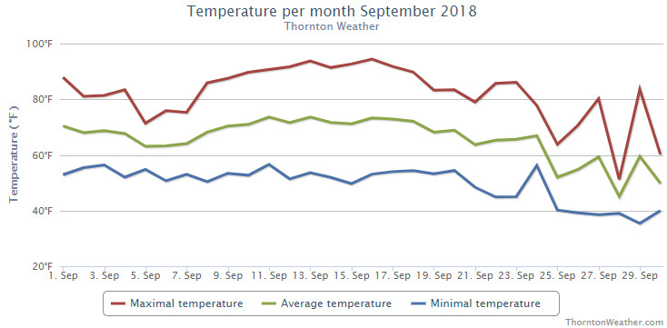
High pressure was a recurring theme for the month of September in 2018. This was the driving force behind many days with above normal temperatures and a mere three days with precipitation.
The ridge seemed to show little movement in the month keeping moisture at bay and any cooler air to the north. The middle of the month in particular bore the brunt of this feature when we saw a string of nine days of 90 degree or higher readings.
Thornton’s average temperature for the month came in at 64.8 degrees. Denver’s long term average for the month is 63.4 degrees so we were a good bit above that.
Out at DIA where the Mile High City’s official measurements are kept, it was considerably warmer with an average this year 67.8 degrees. That puts the month in the books as the sixth warmest September on record – with the asterisk that should always comes with Denver’s stats since the station moved to the airport.
Thornton saw its warmest temperature of 94.4 degrees on the 16th of the month and its coldest of 35.3 degrees on the 29th. Denver saw its maximum for the month of 96 degrees on the 13th and its coldest reading of 36 degrees on the 29th.
Officially, Denver saw four records tied or broken. On the 10th the record high of 93 degrees was tied, a 93 degree reading on the 11th broke the record high for the date and a high of 94 degrees on the 14th was tied the record high. Lastly, a record high minimum of 64 degrees was set on the morning of the 13th.
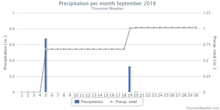
In terms of precipitation, Denver averages 0.96 inches during September. In Thornton, we saw 1.02 inches fall in the bucket with virtually all of that coming on two days. Denver was much drier with only 0.18 inches.
Thornton, Colorado’s September 2018 temperature summary. (ThorntonWeather.com)Thornton, Colorado’s September 2018 precipitation summary. (ThorntonWeather.com)
CLIMATE REPORT
NATIONAL WEATHER SERVICE DENVER/BOULDER CO
303 PM MDT MON OCT 1 2018

...................................

...THE DENVER CO CLIMATE SUMMARY FOR THE MONTH OF SEPTEMBER 2018...

CLIMATE NORMAL PERIOD 1981 TO 2010
CLIMATE RECORD PERIOD 1872 TO 2018

WEATHER         OBSERVED          NORMAL  DEPART  LAST YEAR`S
                 VALUE   DATE(S)  VALUE   FROM    VALUE  DATE(S)
                                          NORMAL
................................................................
TEMPERATURE (F)
RECORD
 HIGH              97   09/03/2017
                        09/06/2013
                        09/05/2013
 LOW               17   09/29/1985
HIGHEST            96   09/13        91       5       97  09/03
LOWEST             36   09/29        35       1       40  09/20
                        09/25
AVG. MAXIMUM     82.7              78.5     4.2     79.0
AVG. MINIMUM     52.8              48.3     4.5     51.3
MEAN             67.8              63.4     4.4     65.1
DAYS MAX >= 90      9               3.4     5.6        9
DAYS MAX <= 32      0               0.0     0.0        0
DAYS MIN <= 32      0               0.8    -0.8        0
DAYS MIN <= 0 0 0.0 0.0 0 PRECIPITATION (INCHES) RECORD MAXIMUM 5.61 2013 MINIMUM T 1892 1944 TOTALS 0.18 0.96 -0.78 1.26 DAILY AVG. 0.01 0.03 -0.02 0.04 DAYS >= .01         5               6.5    -1.5        6
DAYS >= .10         0               3.3    -3.3        2
DAYS >= .50         0               0.6    -0.6        1
DAYS >= 1.00        0               0.1    -0.1        0
GREATEST
 24 HR. TOTAL    0.08   09/19

SNOWFALL (INCHES)
 TOTAL            0.0
RECORD
 TOTAL           17.2  1971         1.3

DEGREE_DAYS
HEATING TOTAL      69               125     -56      122
 SINCE 7/1         78               141     -63      130
COOLING TOTAL     160                76      84      131
 SINCE 1/1       1022               764     258      880

FREEZE DATES
RECORD
 EARLIEST     09/08/1962
 LATEST       06/08/2007
EARLIEST                        10/07
LATEST                          05/05
.................................................................

WIND (MPH)
AVERAGE WIND SPEED              9.7
RESULTANT WIND SPEED/DIRECTION   3/170
HIGHEST WIND SPEED/DIRECTION    37/270    DATE  09/19
HIGHEST GUST SPEED/DIRECTION    49/270    DATE  09/19

SKY COVER
AVERAGE SKY COVER           0.40
NUMBER OF DAYS FAIR           13
NUMBER OF DAYS PC             13
NUMBER OF DAYS CLOUDY          4

AVERAGE RH (PERCENT)     43

WEATHER CONDITIONS. NUMBER OF DAYS WITH
THUNDERSTORMS             5   MIXED PRECIP           0
HEAVY RAIN                0   MODERATE RAIN          0
LIGHT RAIN                9   FREEZING RAIN          0
LT FREEZING RAIN          0   HAIL                   0
HEAVY SNOW                0   SNOW                   0
LIGHT SNOW                0   FOG W/VIS <=1/4 MILE   3
FOG                       5   HAZE                   2

-  INDICATES NEGATIVE NUMBERS.
R  INDICATES RECORD WAS SET OR TIED.
MM INDICATES DATA IS MISSING.
T  INDICATES TRACE AMOUNT.
September 30 to October 6: This week in Denver weather history
Our look back at this week in Denver weather history shows what has historically been a relatively quiet week. However that isn’t to say there aren’t events of note including days with severe thunderstorms, including one date that brought multiple tornadoes.
Be sure to scroll down to the bottom to check out video of one of the tornadoes that struck near Brighton on October 4, 2004.
From the National Weather Service:
30
In 1898…south winds were sustained to 41 mph with gusts to 54 mph.
In 1940…a late season thunderstorm in the city caused one lightning death.
In 1944…the month ended with a trace of rain on this date and for the month. A trace of rain also occurred on the 4th…9th…and 10th. There was no measurable precipitation for the month. The total of a trace of precipitation for the month equaled the driest September on record first set in 1892.
In 2009…a trained spotter in Coal Creek Canyon…recorded a peak wind gust to 88 mph.
30-1
In 1959…heavy snowfall totaled 5.9 inches at Stapleton Airport. Winds were light.
1
In 1892…the highest temperature ever recorded in October… 90 degrees…occurred. This is also the latest 90 degree reading of the season.
In 1898…southwest winds were sustained to 40 mph with gusts to 49 mph in the city.
In 1927…a trace of snow was the only snow of the month… Ranking the year…amongst several other years…the second least snowiest on record.
In 1971…a wind gust to 90 mph was recorded at Buckley Field in Aurora. The severe winds caused damage in northeast metro Denver. A brick wall of a bowling alley was blown down…the roof was blown off a garage…and some business signs were damaged. A man in the bowling alley was injured by flying glass. Northwest winds gusted to 43 mph at Stapleton International Airport.
In 1994…unusually strong thunderstorms for so late in the season pummeled metro Denver with large hail. The largest hail…2 inches in diameter…fell at Buckley Field. Hail 1 3/4 inches in diameter fell 7 miles northeast of Boulder and at Niwot. Hail 3/4 to 1 1/2 inches in diameter fell in Boulder…Arvada…wheat Ridge…Edgewater…capitol hill and northwest Denver…Bennett…and Strasburg. Hail of unknown size damaged a Boeing 737 aircraft and injured both pilots at Stapleton International Airport when the windshield was broken out on takeoff. Half inch diameter hail fell at Stapleton International Airport where northwest winds gusted to 40 mph and rainfall totaled 0.82 inch.
In 2009…strong downslope winds near the foothills produced a peak wind gust to 84 mph at the national wind technology center near Rocky Flats.
In 2014…severe thunderstorms produced wind gusts to 60 mph across parts of Arapahoe and Denver Counties. The intense wind gusts downed trees and power lines which caused a power outage near the Denver Technology Center. At Denver International Airport…a peak wind gust to 37 mph was measured from the northwest.
2
In 1903…southwest winds were sustained to 42 mph with gusts as high as 60 mph. The strong Chinook winds warmed the temperature to a high of 78 degrees.
In 1910…an apparent dry microburst produced sustained northeast winds to 43 mph.
In 1934…a trace of rain was the only precipitation of the month. This was the driest October on record.
3
In 1875…very dense haze hid the mountains from view as observed from the city.
In 1933…rainfall of just 0.01 inch was the only precipitation of the month. This was the second driest October on record.
In 1954…the low temperature cooled to only 60 degrees…the all-time record high minimum for the month October.
3-4
In 1969…the first snowfall of the season totaled 16.0 inches at Stapleton International Airport. There was a thunder snow shower on the evening of the 3rd…but otherwise little wind with the storm. The greatest snow depth on the ground was 8 inches due to melting. Heavy wet snow accumulated on trees…which were still in full leaf…and caused widespread damage from broken limbs and downed utility lines.
Wildlife is still quite active along the Front Range and flowers will hold on to their petals for at least the first part of the month. Then of course there is the weather which you never know what to expect. Thunderstorms, heavy rain, and even snow are a possibility.
Slideshow updated September 30, 2018
To learn more about how to send your photo to us for inclusion in the slideshow, see below the slideshow.
Showcasing images captured by ThorntonWeather.com readers as well as some of our own, our monthly slideshow covers the entire gamut of weather-related imagery.
Sunsets, sunrises, wildlife and of course every type of weather condition are vividly depicted in images captured from yours and our cameras.
[flickr_set id=”72157700963292955″]
What is missing in the slideshow above? Your photo!
Our monthly photo slideshow is going to feature images that we have taken but more importantly images that you have captured. The photos can be of anything even remotely weather-related.
Landscapes, current conditions, wildlife, pets, kids. Whimsical, newsy, artsy. Taken at the zoo, some other area attraction, a local park, a national park or your backyard. You name it, we want to see and share it!
Images can be taken in Thornton, Denver or anywhere across the extraordinary Centennial State. We’ll even take some from out of state if we can tie it to Colorado somehow.
We’ll keep the criteria very open to interpretation with just about any image eligible to be shown in our slideshows.
What do you win for having your image in our slideshow? We are just a ‘mom and pop’ outfit and make no money from our site so we really don’t have the means to provide prizes. However you will have our undying gratitude and the satisfaction that your images are shared on the most popular website in Thornton.
To share you images with us and get them included in the slideshow just email them to us or share them with ThorntonWeather.com on any of the various social media outlets. Links are provided below.
Rocky Mountain National Park is a prime spot for viewing the fall foliage. (Tony’s Takes)
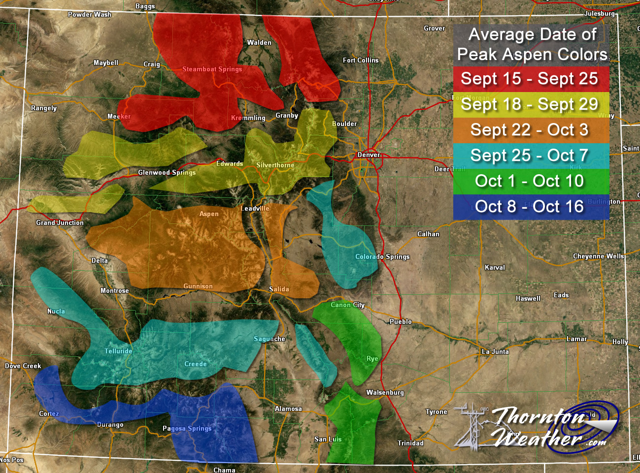
This time of year many folks start thinking about heading to the hills west of Denver in search of gold – fall foliage gold.
Where to go? Below are five of ThorntonWeather.com’s favorite ones near Denver – plus a few further out and some bonus ideas. After that, we will tell you where you can find a great website that provides regular updates on viewing conditions.
I-70 Corridor – If you’re looking for the easiest route, then this one is for you. Simply head west on I-70 about 110 miles to Avon. Between Vail and Avon, both sides of I-70 are lined beautifully with aspen.
Rocky Mountain National Park – One of the most popular summer destinations in the state is of course also a prime spot to view aspen in all their glory. Once in the park head toward Bear Lake. Glacier Gorge Junction provides a beautiful spot and you of course also get to enjoy all the splendor that Rocky Mountain National Park has to offer. Extend your viewing by taking Trail Ridge Road all the way through to the west side of the park and the Grand Lake and Granby area.
Peak to Peak Highway – This little road trip can be a dual purpose trip – gambling and fall foliage viewing! Take U.S. 6 through Clear Creek Canyon and then 119 through Blackhawk and Central City. You can of course stop there if your wallet is fat enough and donate some money to the casinos. From there continue on 119 toward Nederland. Take highway 72 toward Ward and Allenspark. There you will find more golden aspen than you can imagine, all with the Continental Divide nearby.
Colorado Fall Foliage – Average Date of Peak Aspen Colors. Click for larger view. (ThorntonWeather.com)
Poudre Valley Canyon – Heading north on I-25 take Colorado 14 west and into Poudre Canyon and Roosevelt National Forest. As you continue west you will come very near timberline as you come to Cameron Pass. Amazing views abound!
Guanella Pass – This is a nice, relatively short drive from Denver. From C470 take 85 through Bailey and Conifer, a nice drive unto itself. When you come to the town of Grant, take the Guanella Pass Scenic and Historic Byway north to Georgetown. The air is pretty thin along the way as you climb in excess of 11,500 views through the Pike and Arapahoe National Forests.
A couple other possibilities further from the Front Range:
Leadville / Aspen – From Denver take I-70 west to Copper Mountain and then Colorado 91 south over Freemont Pass to Leadville. Along the way there are plenty of viewing opportunities and Leadville is a nice little town to make a stop. From here you can take Highway 24 north back through Minturn and Vail. To extend the drive, take Highway 24 south to Colorado 82 and head toward Aspen. You can stop by the Maroon Bells in White River National Forest to view some of the most photographed mountains in Colorado.
Cottonwood Pass – From Denver take Highway 285 to Buena Vista. Head west on Main Street for seven miles then west on County Road 344 / Colorado 82. From there you start the climb up Cottonwood Pass with absolutely stunning views from the top. If you are up for it, you can continue down the west side of the pass into the Taylor Park area. Be forewarned though that the western half of the pass is unpaved and twisty. Editor’s note: The west side of Cottonwood Pass is closed until sometime this fall so that it can be paved.
Honorable mentions worth considering:
Boreas Pass between Breckenridge and Como (County Road 10)
Kenosha Pass on Highway 285 between Bailey and Fairplay
Independence Pass (Colorado 82 between Aspen and Twin Lakes)
Colorado 103 from Evergreen to Echo Lake. Throw in a drive up Mount Evans for a bonus.
If you do head out, be sure to send us your pictures for inclusion in our monthly photo slideshows!
And down goes another record! We didn’t expect it to get quite as hot as it did but Mother Nature gave the mercury a little extra push into record-setting territory today.
Denver’s official high temperature, as measured at DIA, came in at 96 degrees today. This tied the record high temperature for September 13 set in 1990 and 1895.
Here in Thornton, we were just a touch cooler as is the norm with a high of 94 degrees.
We wish we could say we were done with the 90+ degree readings for the season but that does not appear to be the case.
Currently it looks like we will be at or a bit above the 90 degree mark through Monday. It may be the end of next week before we see any appreciable cooling. Check out the extended forecast here.
Weather, natural disasters & climate news and information.

 The weather during the month of November in Denver metro area can offer just about anything. While it is normally a quiet month, it can be prone to extremes.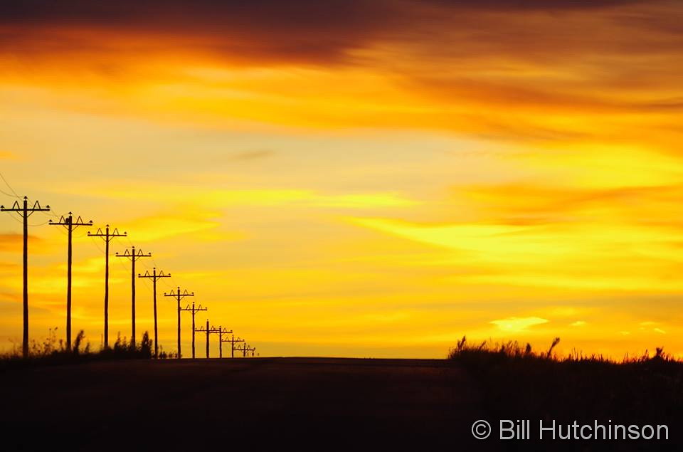

 With the first full month of fall here, October usually brings one of the quietest weather months in the Denver area with plenty of mild, sunny days and clear, cool nights.