Well, that was fun, eh? Well, probably not for those stuck in traffic when the snowstorm hit this morning.
The storm over-performed big time, far exceeding forecasts. Upslope flow pushed the system against the mountains and kept it in place over the Front Range.
Our east webcam captures it all in a time lapse.
Snow begins at about 3:00am and continued through much of the morning. By the end of the day though, blue skies returned and the snow was melting. We recorded 4.2 inches here but know many spots, particularly to the west, got more.
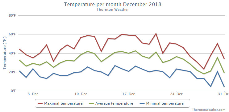
Thornton’s December was lacking in terms of any sort of real weather drama. Temperatures were relatively mild for much of the month and precipitation was fleeting.
Above normal temperatures were the general rule for the first part of the month. It was only the last week of the month when Arctic air arrived and we saw temperatures drop considerably. We saw only two measurable snow events, neither of which amounted to much.
Overall, Thornton’s average temperature for the month was 30.8 degrees. This was nearly a full degree above Denver’s long term December average of 30.0 degrees. Out at DIA where the Mile High City’s official measurements are taken, it was a good bit warmer with an average of 32.5 degrees.
Temperatures in Thornton ranged from a high of 60.6 degrees on the 21st down to a low of 4.5 degrees on the morning of the 29th. Denver’s warmest reading of 63 degrees also came on the 21st and its coldest, 0 degrees, on the 31st.
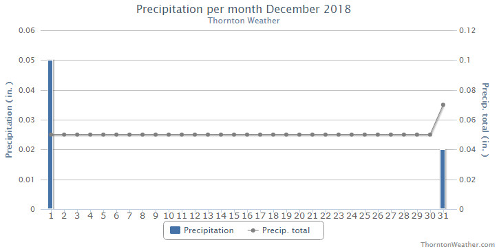
Denver averages 0.35 inches of precipitation during December. Thornton fell well short with a mere 0.07 inches. Out at the airport, even less was realized with 0.03 being recorded. This puts December 2018 into the books as one of the driest Decembers ever recorded.
Thornton recorded a mere 0.9 inches of snow during the month, the majority of which fell on the last day of the month. Denver saw 0.5 inches, all on the 31st. Both fall well short of the long term Denver average for December snowfall of 8.5 inches and put December 2018 on the list of the ten least snowy Decembers recorded.
Ten least snowy December’s in Denver weather history:
TRACE – 1905, 1906, 2002
0.1 – 1928
0.4 – 1890
0.5 – 1935, 2018
0.6 – 1995
0.7 – 1977, 1895
Thornton, Colorado’s December 2018 Temperature Summary. (ThorntonWeather.com)Thornton, Colorado’s December 2018 Precipitation Summary. (ThorntonWeather.com)
CLIMATE REPORT
NATIONAL WEATHER SERVICE DENVER/BOULDER CO
936 AM MST TUE JAN 1 2019

...................................

...THE DENVER CO CLIMATE SUMMARY FOR THE MONTH OF DECEMBER 2018...

CLIMATE NORMAL PERIOD 1981 TO 2010
CLIMATE RECORD PERIOD 1872 TO 2018

WEATHER         OBSERVED          NORMAL  DEPART  LAST YEAR`S
                 VALUE   DATE(S)  VALUE   FROM    VALUE  DATE(S)
                                          NORMAL
................................................................
TEMPERATURE (F)
RECORD
 HIGH              79   12/05/1939
 LOW              -25   12/22/1990
                        12/24/1876
HIGHEST            63   12/21        62       1       69  12/12
LOWEST              0   12/31        -4       4       -4  12/24
AVG. MAXIMUM     46.1              42.8     3.3     48.3
AVG. MINIMUM     18.8              17.1     1.7     18.0
MEAN             32.5              30.0     2.5     33.2
DAYS MAX >= 90      0               0.0     0.0        0
DAYS MAX <= 32      4               5.8    -1.8        4
DAYS MIN <= 32     31              29.4     1.6       28
DAYS MIN <= 0       1               2.0    -1.0        1

PRECIPITATION (INCHES)
RECORD
 MAXIMUM         5.21   1913
 MINIMUM         0.00   1881
TOTALS           0.03              0.35   -0.32     0.21
DAILY AVG.       0.00              0.01   -0.01     0.01
DAYS >= .01         1               4.1    -3.1        4
DAYS >= .10         0               1.1    -1.1        1
DAYS >= .50         0               0.1    -0.1        0
DAYS >= 1.00        0               0.0     0.0        0
GREATEST
 24 HR. TOTAL    0.03   12/31 TO 12/31

SNOWFALL (INCHES)
TOTALS            0.5               8.5

DEGREE_DAYS
HEATING TOTAL     999              1086     -87      979
 SINCE 7/1       2372              2468     -96     2150
COOLING TOTAL       0                 0       0        0
 SINCE 1/1       1026               769     257      881

FREEZE DATES
RECORD
 EARLIEST     09/08/1962
 LATEST       06/08/2007
EARLIEST                        10/07
LATEST                          05/05
.................................................................

WIND (MPH)
AVERAGE WIND SPEED              9.6
RESULTANT WIND SPEED/DIRECTION   2/222
HIGHEST WIND SPEED/DIRECTION    39/010    DATE  12/12
HIGHEST GUST SPEED/DIRECTION    53/010    DATE  12/12

SKY COVER
POSSIBLE SUNSHINE (PERCENT)   MM
AVERAGE SKY COVER           0.50
NUMBER OF DAYS FAIR            6
NUMBER OF DAYS PC             22
NUMBER OF DAYS CLOUDY          3

AVERAGE RH (PERCENT)     51

-  INDICATES NEGATIVE NUMBERS.
R  INDICATES RECORD WAS SET OR TIED.
MM INDICATES DATA IS MISSING.
T  INDICATES TRACE AMOUNT.
As we begin the new year the winter chill begins to set in. While January can see its share of extremes, the month historically sees stable temperatures and is usually relatively dry.
January ranks as the second coldest month in Denver next to December with average temperatures remaining virtually the same from the start to the end of the month.
In terms of snowfall, the month only ranks as the fourth snowiest and it is not uncommon for it to be quite dry.
What does January 2019 hold for us? Follow the link to find out.
A beautiful sunset over downtown Denver to start the month of December. (Alisa H)
The month of December can offer everything from bone dry conditions to bone chilling cold and monstrous snowstorms. The weather and wildlife all afford an abundance of photo opportunities as our December photo slideshow shows.
Leaves have fallen from trees now and the landscape can sometimes look quite stark. However it only takes a quick shot of snow to change that picture greatly. Throw in gorgeous sunrises and sunsets, plenty of wildlife big and small, kids playing and much more and the month can be quite colorful and eventful.
Slideshow updated December 31, 2018
To learn more about how to send your photo to us for inclusion in the slideshow, see below the slideshow.
Showcasing images captured by ThorntonWeather.com readers as well as some of our own, our monthly slideshow covers the entire gamut of weather-related imagery.
Sunsets, sunrises, wildlife and of course every type of weather condition are vividly depicted in images captured from yours and our cameras.
[flickr_set id=”72157702984201741″]
What is missing in the slideshow above? Your photo!
Our monthly photo slideshow is going to feature images that we have taken but more importantly images that you have captured. The photos can be of anything even remotely weather-related.
Landscapes, current conditions, wildlife, pets, kids. Whimsical, newsy, artsy. Taken at the zoo, some other area attraction, a local park, a national park or your backyard. You name it, we want to see and share it!
Images can be taken in Thornton, Denver or anywhere across the extraordinary Centennial State. We’ll even take some from out of state if we can tie it to Colorado somehow.
We’ll keep the criteria very open to interpretation with just about any image eligible to be shown in our slideshows.
What do you win for having your image in our slideshow? We are just a ‘mom and pop’ outfit and make no money from our site so we really don’t have the means to provide prizes. However you will have our undying gratitude and the satisfaction that your images are shared on the most popular website in Thornton.
To share you images with us and get them included in the slideshow just email them to us or share them with ThorntonWeather.com on any of the various social media outlets. Links are provided below.
Winter officially begins at 9:28am MST on Thursday, December 21, 2017. (NOAA)
Astronomical winter arrives in Thornton Friday afternoon and with the solstice also comes the shortest day of the year.
Winter officially begins at 3:23pm MST on Friday, December 21.
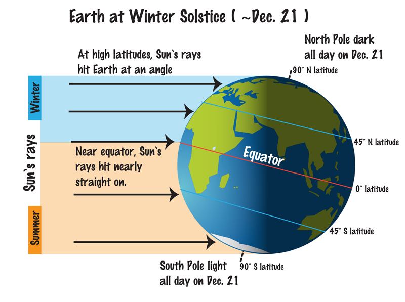
The Winter Solstice occurs when the North Pole is tilted at its furthest from the sun – 23.5 degrees away. This results in the shortest day of the year in the Northern Hemisphere.
Here in Denver, with sunrise at 7:17am and sunset at 4:38pm, our day Friday will be 9 hours, 21 minutes and 16 seconds long.
The following day, Saturday, it will be one second longer and each day from now through to the Summer Solstice in June will get gradually longer as well.
While we have a short day today, it is nothing like what will be experienced in the Arctic Circle. Areas north of there to the North Pole will have no direct sunlight at all. Conversely, areas south of the Antarctic Circle toward the South Pole will have 24 hours of daylight and have a midnight sun.
Did you know that there is a difference between the astronomical seasons that we are discussing here and meteorological seasons?
Meteorological seasons differ slightly and are geared toward matching the calendar with the annual temperature cycle. This is done primarily for meteorological observing and forecasting and in many ways it is more logical than the astronomical seasons.
For the Northern Hemisphere, the meteorological spring covers the months of March, April and May. Summer brings the hottest months of the year and so meteorological summer is June, July and August. Meteorological fall then is September, October and November followed by the coldest months of December, January and February as meteorological winter.
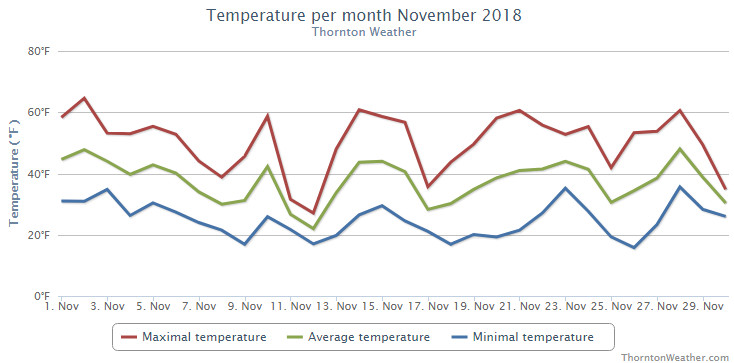
Thornton’s month of November saw us get a real taste of what is to come for the next few months. Temperatures cooled considerably and we saw a decent bit of snow although not as much as normal.
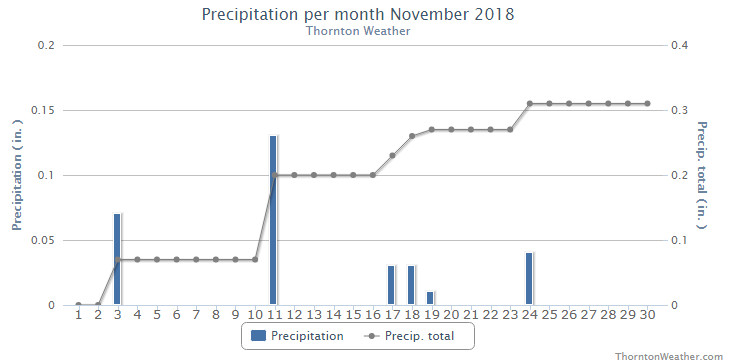
The first five days of the month started out relatively mild but then we saw a series of systems interrupt the calm. Temperatures turned colder and on the 11th and 12th we received a nice little snowfall. We briefly warmed up then saw some light rain on the 18th and 19th and then once again warmed back up. The month closed out with a chilly day and some light snow.
Thornton saw an overall average temperature for the month of 36.8 degrees. This was a good bit colder than Denver’s long term average for the month of 38.3 degrees. Out at DIA where Denver’s official measurements are taken, it was a good bit warmer with an average of 37.8 degrees.
Temperatures for us ranged from a high of 64.7 degrees on the 2nd of the month down to a cold low of 15.7 degrees on the morning of the 26th. Denver’s high of 65 degrees on the 2nd matched ours but their coldest reading of 10 on the 12th was notably colder than our lowest reading.
November’s long term precipitation average in Denver is 0.61 inches. Thornton managed about half that in our bucket with 0.31 inches with Denver close to us at 0.35 inches.
Snowfall was respectable but not notable. Thornton recorded 6.3 inches of the white stuff while Denver, as usual, lagged with 4.5 inches. Both measurements were below Denver’s long term November average of 8.7 inches.
Thornton, Colorado’s November 2018 temperature summary. (ThorntonWeather.com)Thornton, Colorado’s November 2018 precipitation summary. (ThorntonWeather.com)
CLIMATE REPORT
NATIONAL WEATHER SERVICE DENVER/BOULDER CO
929 AM MST MON DEC 3 2018

...................................

...THE DENVER CO CLIMATE SUMMARY FOR THE MONTH OF NOVEMBER 2018...

CLIMATE NORMAL PERIOD 1981 TO 2010
CLIMATE RECORD PERIOD 1872 TO 2018

WEATHER         OBSERVED          NORMAL  DEPART  LAST YEAR`S
                 VALUE   DATE(S)  VALUE   FROM    VALUE  DATE(S)
                                          NORMAL
................................................................
TEMPERATURE (F)
RECORD
 HIGH              81   11/27/2017
 LOW              -18   11/29/1877
HIGHEST            65   11/02        73      -8       81  11/27
LOWEST             10   11/12        -6      16       22  11/15
                                                          11/12
AVG. MAXIMUM     50.6              52.1    -1.5     61.1
AVG. MINIMUM     25.0              24.5     0.5     29.4
MEAN             37.8              38.3    -0.5     45.3
DAYS MAX >= 90      0               0.0     0.0        0
DAYS MAX <= 32      2               2.3    -0.3        0
DAYS MIN <= 32     27              23.4     3.6       22
DAYS MIN <= 0       0               0.6    -0.6        0

PRECIPITATION (INCHES)
RECORD
 MAXIMUM         3.21   1946
 MINIMUM            T   1899
                        1901
                        1949
TOTALS           0.35              0.61   -0.26     0.29
DAILY AVG.       0.01              0.02   -0.01     0.01
DAYS >= .01         6               4.7     1.3        3
DAYS >= .10         1               1.6    -0.6        1
DAYS >= .50         0               0.0     0.0        0
DAYS >= 1.00        0               0.0     0.0        0
GREATEST
 24 HR. TOTAL    0.17   11/11 TO 11/11           11/17 TO 11/17

SNOWFALL (INCHES)
RECORDS
TOTAL             4.5               8.7
RECORD NOVEMBER  42.5  1946

DEGREE_DAYS
HEATING TOTAL     808               801       7      586
 SINCE 7/1       1373              1382      -9     1171
COOLING TOTAL       0                 0       0        0
 SINCE 1/1       1026               769     257      881

FREEZE DATES
RECORD
 EARLIEST     09/08/1962
 LATEST       06/08/2007
EARLIEST                        10/07
LATEST                          05/05
.................................................................

WIND (MPH)
AVERAGE WIND SPEED              9.8
RESULTANT WIND SPEED/DIRECTION   2/225
HIGHEST WIND SPEED/DIRECTION    48/330    DATE  11/24
HIGHEST GUST SPEED/DIRECTION    62/320    DATE  11/24

SKY COVER
POSSIBLE SUNSHINE (PERCENT)   MM
AVERAGE SKY COVER           0.50
NUMBER OF DAYS FAIR            8
NUMBER OF DAYS PC             16
NUMBER OF DAYS CLOUDY          6

AVERAGE RH (PERCENT)     56

WEATHER CONDITIONS. NUMBER OF DAYS WITH
THUNDERSTORMS             0      MIXED PRECIP       0
HEAVY RAIN                0      RAIN               0
LIGHT RAIN                2      FREEZING RAIN      0
LIGHT FREEZING RAIN       1      HAIL               0
HEAVY SNOW                0      SNOW               3
LIGHT SNOW                9      SLEET              0
FOG                       8      DENSE FOG          2
HAZE                      2

-  INDICATES NEGATIVE NUMBERS.
R  INDICATES RECORD WAS SET OR TIED.
MM INDICATES DATA IS MISSING.
T  INDICATES TRACE AMOUNT.
November brought Thornton cooler than normal temperatures and a bit more snow than usual. What will December hold for us?
The month of December brings with it the official start of winter and oftentimes, colder and snowier weather conditions.
It however can also offer unseasonably warm temperatures and bone dry conditions. Given our recent mild and dry weather, we are certainly hoping for a change in the coming month.
Overall December’s monthly mean temperature of 30.0 degrees (1981 – 2010 averages) makes it our coldest month. Snow is always on everyone’s mind this time of year but December is only our 3rd snowiest month behind March and November with an average of 8.5 inches of the white stuff.
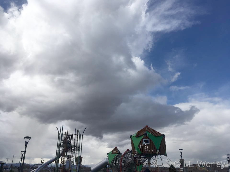
Cool clouds over Thornton on an unsettled day. (LE Worley)
Typically November is a quiet weather month with plenty of nice, fall days but it can also turn wet with healthy doses of snow and moisture. The wide variety of conditions can create picturesque scenes ranging from blue skies and snow-capped mountains to a wintry wonderland in the metro area.
November is the second snowiest month of the year so winter conditions are not unusual. Typically though, these bouts of cold are short-lived and normal daytime conditions are pleasant.
Outdoor activities continue to be quite popular during the month. The cooling temperatures do oftentimes lead to an increase in wildlife activity.
All of the above help lead to a month in which a wide variety of scenes, flora and fauna can be captured.
Slideshow updated November 28, 2018
To learn more about how to send your photo to us for inclusion in the slideshow, see below the slideshow.
Showcasing images captured by ThorntonWeather.com readers as well as some of our own, our monthly slideshow covers the entire gamut of weather-related imagery.
Sunsets, sunrises, wildlife and of course every type of weather condition are vividly depicted in images captured from yours and our cameras.
[flickr_set id=”72157699958645692″]
What is missing in the slideshow above? Your photo!
Our monthly photo slideshow is going to feature images that we have taken but more importantly images that you have captured. The photos can be of anything even remotely weather-related.
Landscapes, current conditions, wildlife, pets, kids. Whimsical, newsy, artsy. Taken at the zoo, some other area attraction, a local park, a national park or your backyard. You name it, we want to see and share it!
Images can be taken in Thornton, Denver or anywhere across the extraordinary Centennial State. We’ll even take some from out of state if we can tie it to Colorado somehow.
We’ll keep the criteria very open to interpretation with just about any image eligible to be shown in our slideshows.
What do you win for having your image in our slideshow? We are just a ‘mom and pop’ outfit and make no money from our site so we really don’t have the means to provide prizes. However you will have our undying gratitude and the satisfaction that your images are shared on the most popular website in Thornton.
To share you images with us and get them included in the slideshow just email them to us or share them with ThorntonWeather.com on any of the various social media outlets. Links are provided below.
Weather Geek Stuff is a great place to shop for gifts for weather enthusiasts, weather geeks and weather lovers.
Not everyone gets excited about blizzards, tornadoes, hurricanes and other types of extreme weather but many folks out there are passionate about Mother Nature. Weather Geek Stuff is an online shop just for those whose hearts race with the thrill of severe weather and they are offering special deals through the holiday season.
Weather Geek Stuff is an online store that provides a host of clothing items and novelties just for weather buffs. From the store’s custom ‘Weather Geek’ and ‘Weather Diva’ logoed merchandise to items imprinted with amusing weather warnings signs as well as Skywarn storm spotter logos, there is something there sure to please any weather lover.
Weather Geek Stuff’s merchandise was shown on the Weather Channel as a recommended gift so you know the quality is good. Stu Ostro, Weather Channel’s Senior Director of Weather Communications even sports a ‘Weather Geek’ t-shirt on his Twitter profile.
Kids and dogs aren’t left out of the weather fun either. There is a wide variety of clothing items sized just right for the little ones from babies to bigger kids. Canine companions as well can get shirts and bowls emblazoned with a weather-related logo.
The selection goes far beyond clothing too. Water bottles, clocks, mugs, bags and other novelties are part of the store’s offerings. For the tech types, cases for iPhones and iPads are available. Recently added products include laptop skins, clipboards and throw blankets.
Weather Geek Stuff is owned and operated by the same folks that run ThorntonWeather.com. We provide ThorntonWeather.com as a no-cost service to the community and use the minimal amount of money made from Weather Geek Stuff to support the costs of running this website and the associated equipment. So remember, if you have a weather buff on your shopping list, by buying from Weather Geek Stuff you are supporting ThorntonWeather.com! You can also donate directly to fund the site here.
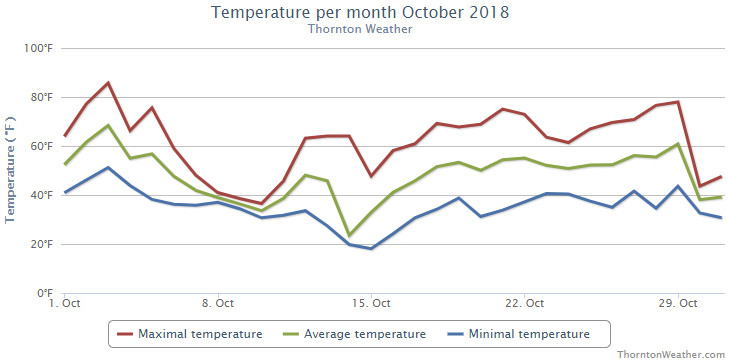
Fall arrived in earnest during the month of October 2018 as temperatures cooled considerably and we saw our first snowfall of the season.
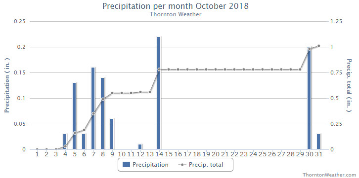
The first two weeks of the month were notable for seeing 12 of 17 days with below normal temperatures. Five days in a row with measurable rain came from the 4th to the 9th and then on the 14th we saw that first snowfall.
The latter half of the month warmed up with above normal mercury readings being seen on all but the last two days of the October. That same stretch of mild days also was one in which we saw no precipitation.
While the overall warm end of the month helped, we still saw overall monthly temperature readings well below normal.
Thornton’s average monthly temperature came in at 47.0 degrees. This is in comparison to Denver’s long term October average of 50.9 degrees, a near 4 degree difference. Out at Denver International Airport where the Mile High City’s official readings are taken, it was a bit warmer with an average for the month of 49.2 degrees.
Here, we ranged from a high of 85.7 degrees on the 3rd down to a low of 18.1 degrees on the morning of the 15th. Denver saw a max of 86 degrees and a low of 18 degrees, each on the same days as our max and min.
Denver set two temperature records during the month. The high temperature of only 27 degrees on the 14th set a new record low maximum for the date. This easily bested the old record of 36 degrees set in 1969. A record low temperature reading of 18 degrees on the 15th topped the previous record low for the date of 20 degrees set in 1970.
In terms of precipitation, Thornton recorded 1.01 inches between rain and snow melt. Denver was very similar with a total of 0.99 inches. Both measurements were close to the long term Denver average of 1.02 inches for the month.
Thornton saw a relatively minimal 2.8 inches of snowfall, all on the 14th. Denver recorded a bit more of the white stuff with 3.2 inches. Both were short of the October average of 4.0 inches.
Thornton, Colorado’s October 2018 temperature summary. (ThorntonWeather.com)Thornton, Colorado’s October 2018 precipitation summary. (ThorntonWeather.com)
...THE DENVER CO CLIMATE SUMMARY FOR THE MONTH OF OCTOBER 2018...

CLIMATE NORMAL PERIOD 1981 TO 2010
CLIMATE RECORD PERIOD 1872 TO 2018

WEATHER         OBSERVED          NORMAL  DEPART  LAST YEAR`S
                 VALUE   DATE(S)  VALUE   FROM    VALUE  DATE(S)
                                          NORMAL
................................................................
TEMPERATURE (F)
RECORD
 HIGH              90   10/01/1892
 LOW               -2   10/29/1917
HIGHEST            86   10/03        83       3       84  10/25
LOWEST             18   10/15        22      -4       13  10/27
AVG. MAXIMUM     61.6              65.3    -3.7     64.5
AVG. MINIMUM     36.8              36.6     0.2     35.7
MEAN             49.2              50.9    -1.7     50.1
DAYS MAX >= 90      0               0.0     0.0        0
DAYS MAX <= 32      1               0.4     0.6        0
DAYS MIN <= 32      7               8.5    -1.5       11
DAYS MIN <= 0       0               0.0     0.0        0

PRECIPITATION (INCHES)
RECORD
 MAXIMUM         4.17   1969
 MINIMUM            T   1934
TOTALS           0.99              1.02   -0.03     0.96
DAILY AVG.       0.03              0.03    0.00     0.03
DAYS >= .01         9               5.3     3.7        5
DAYS >= .10         3               2.4     0.6        4
DAYS >= .50         0               0.5    -0.5        0
DAYS >= 1.00        0               0.1    -0.1        0
GREATEST
 24 HR. TOTAL    0.31   10/07 TO 10/07           10/09 TO 10/09

SNOWFALL (INCHES)
RECORDS
TOTAL             3.2               4.0
RECORD NOVEMBER  38.9  1969

DEGREE_DAYS
HEATING TOTAL     487               440      47      455
 SINCE 7/1        565               581     -16      585
COOLING TOTAL       4                 5      -1        1
 SINCE 1/1       1026               769     257      881

FREEZE DATES
RECORD
 EARLIEST     09/08/1962
 LATEST       06/08/2007
EARLIEST      10/10             10/07
LATEST                          05/05
.................................................................

WIND (MPH)
AVERAGE WIND SPEED              9.7
RESULTANT WIND SPEED/DIRECTION   2/186
HIGHEST WIND SPEED/DIRECTION    39/360    DATE  10/29
HIGHEST GUST SPEED/DIRECTION    49/360    DATE  10/29

SKY COVER
POSSIBLE SUNSHINE (PERCENT)   MM
AVERAGE SKY COVER           0.60
NUMBER OF DAYS FAIR            7
NUMBER OF DAYS PC             16
NUMBER OF DAYS CLOUDY          8

AVERAGE RH (PERCENT)     59

WEATHER CONDITIONS. NUMBER OF DAYS WITH
THUNDERSTORMS             5      MIXED PRECIP       2
HEAVY RAIN                0      RAIN               3
LIGHT RAIN               12      FREEZING RAIN      0
LIGHT FREEZING RAIN       0      HAIL               0
HEAVY SNOW                0      SNOW               3
LIGHT SNOW                6      SLEET              0
FOG                      11      DENSE FOG          4
HAZE                      2

-  INDICATES NEGATIVE NUMBERS.
R  INDICATES RECORD WAS SET OR TIED.
MM INDICATES DATA IS MISSING.
T  INDICATES TRACE AMOUNT.
Weather, natural disasters & climate news and information.

 As we begin the new year the winter chill begins to set in. While January can see its share of extremes, the month historically sees stable temperatures and is usually relatively dry.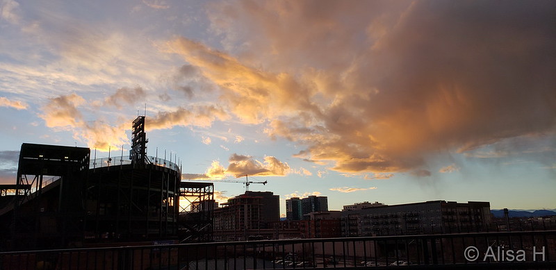
 November brought Thornton cooler than normal temperatures and a bit more snow than usual. What will December hold for us?