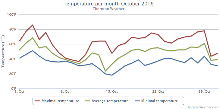
Fall arrived in earnest during the month of October 2018 as temperatures cooled considerably and we saw our first snowfall of the season.
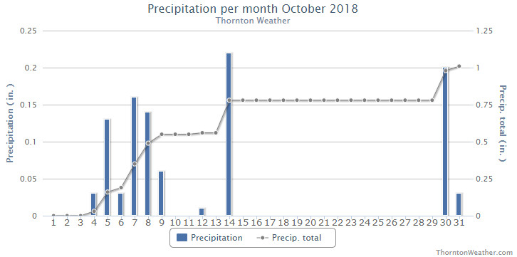
The first two weeks of the month were notable for seeing 12 of 17 days with below normal temperatures. Five days in a row with measurable rain came from the 4th to the 9th and then on the 14th we saw that first snowfall.
The latter half of the month warmed up with above normal mercury readings being seen on all but the last two days of the October. That same stretch of mild days also was one in which we saw no precipitation.
While the overall warm end of the month helped, we still saw overall monthly temperature readings well below normal.
Thornton’s average monthly temperature came in at 47.0 degrees. This is in comparison to Denver’s long term October average of 50.9 degrees, a near 4 degree difference. Out at Denver International Airport where the Mile High City’s official readings are taken, it was a bit warmer with an average for the month of 49.2 degrees.
Here, we ranged from a high of 85.7 degrees on the 3rd down to a low of 18.1 degrees on the morning of the 15th. Denver saw a max of 86 degrees and a low of 18 degrees, each on the same days as our max and min.
Denver set two temperature records during the month. The high temperature of only 27 degrees on the 14th set a new record low maximum for the date. This easily bested the old record of 36 degrees set in 1969. A record low temperature reading of 18 degrees on the 15th topped the previous record low for the date of 20 degrees set in 1970.
In terms of precipitation, Thornton recorded 1.01 inches between rain and snow melt. Denver was very similar with a total of 0.99 inches. Both measurements were close to the long term Denver average of 1.02 inches for the month.
Thornton saw a relatively minimal 2.8 inches of snowfall, all on the 14th. Denver recorded a bit more of the white stuff with 3.2 inches. Both were short of the October average of 4.0 inches.
Click here to view Thornton’s October 2018 climate report.
...THE DENVER CO CLIMATE SUMMARY FOR THE MONTH OF OCTOBER 2018...

CLIMATE NORMAL PERIOD 1981 TO 2010
CLIMATE RECORD PERIOD 1872 TO 2018

WEATHER         OBSERVED          NORMAL  DEPART  LAST YEAR`S
                 VALUE   DATE(S)  VALUE   FROM    VALUE  DATE(S)
                                          NORMAL
................................................................
TEMPERATURE (F)
RECORD
 HIGH              90   10/01/1892
 LOW               -2   10/29/1917
HIGHEST            86   10/03        83       3       84  10/25
LOWEST             18   10/15        22      -4       13  10/27
AVG. MAXIMUM     61.6              65.3    -3.7     64.5
AVG. MINIMUM     36.8              36.6     0.2     35.7
MEAN             49.2              50.9    -1.7     50.1
DAYS MAX >= 90      0               0.0     0.0        0
DAYS MAX <= 32      1               0.4     0.6        0
DAYS MIN <= 32      7               8.5    -1.5       11
DAYS MIN <= 0       0               0.0     0.0        0

PRECIPITATION (INCHES)
RECORD
 MAXIMUM         4.17   1969
 MINIMUM            T   1934
TOTALS           0.99              1.02   -0.03     0.96
DAILY AVG.       0.03              0.03    0.00     0.03
DAYS >= .01         9               5.3     3.7        5
DAYS >= .10         3               2.4     0.6        4
DAYS >= .50         0               0.5    -0.5        0
DAYS >= 1.00        0               0.1    -0.1        0
GREATEST
 24 HR. TOTAL    0.31   10/07 TO 10/07           10/09 TO 10/09

SNOWFALL (INCHES)
RECORDS
TOTAL             3.2               4.0
RECORD NOVEMBER  38.9  1969

DEGREE_DAYS
HEATING TOTAL     487               440      47      455
 SINCE 7/1        565               581     -16      585
COOLING TOTAL       4                 5      -1        1
 SINCE 1/1       1026               769     257      881

FREEZE DATES
RECORD
 EARLIEST     09/08/1962
 LATEST       06/08/2007
EARLIEST      10/10             10/07
LATEST                          05/05
.................................................................

WIND (MPH)
AVERAGE WIND SPEED              9.7
RESULTANT WIND SPEED/DIRECTION   2/186
HIGHEST WIND SPEED/DIRECTION    39/360    DATE  10/29
HIGHEST GUST SPEED/DIRECTION    49/360    DATE  10/29

SKY COVER
POSSIBLE SUNSHINE (PERCENT)   MM
AVERAGE SKY COVER           0.60
NUMBER OF DAYS FAIR            7
NUMBER OF DAYS PC             16
NUMBER OF DAYS CLOUDY          8

AVERAGE RH (PERCENT)     59

WEATHER CONDITIONS. NUMBER OF DAYS WITH
THUNDERSTORMS             5      MIXED PRECIP       2
HEAVY RAIN                0      RAIN               3
LIGHT RAIN               12      FREEZING RAIN      0
LIGHT FREEZING RAIN       0      HAIL               0
HEAVY SNOW                0      SNOW               3
LIGHT SNOW                6      SLEET              0
FOG                      11      DENSE FOG          4
HAZE                      2

-  INDICATES NEGATIVE NUMBERS.
R  INDICATES RECORD WAS SET OR TIED.
MM INDICATES DATA IS MISSING.
T  INDICATES TRACE AMOUNT.
 The weather during the month of November in Denver metro area can offer just about anything. While it is normally a quiet month, it can be prone to extremes.

 With the first full month of fall here, October usually brings one of the quietest weather months in the Denver area with plenty of mild, sunny days and clear, cool nights.