April marks a transition between winter and summer for most of the country but for Denver it is especially true as we can see a stunning variety of weather.
The proverbial April showers are certainly a possibility for Denver. Snow? Tornadoes? Thunderstorms? You bet – all can happen!
For good measure throw in a chance for hail and even dust storms and April gives every type of weather condition you could like – or hate.
A bald eagle takes flight over Adams County. (Bill Hutchinson)
The month of March is the start of meteorological spring and while conditions do begin warming, winter weather is certainly out of the question. From hot to cold, snow to rain, the conditions can be very conducive to great pictures as we see in our slideshow.
March in Denver typically means frequent and rapid weather changes. The days grow longer and we start enjoying more sunshine and sometimes summer-like weather. However, on occasion arctic air masses can still force their way south into Colorado dropping temperatures quickly and markedly.
With the active wildlife, increased outdoor activities by us humans, and of course the weather, March imagery contains a wide variety of subjects and extremes.
Slideshow updated March 28, 2019. To learn more about how to send your photo to us for inclusion in the slideshow, see below the slideshow.
Showcasing images captured by ThorntonWeather.com readers as well as some of our own, our monthly slideshow covers the entire gamut of weather-related imagery.
Sunsets, sunrises, wildlife and of course every type of weather condition are vividly depicted in images captured from yours and our cameras.
[flickr_set id=”72157707169706485″]
What is missing in the slideshow above? Your photo!
Our monthly photo slideshow is going to feature images that we have taken but more importantly images that you have captured. The photos can be of anything even remotely weather-related.
Landscapes, current conditions, wildlife, pets, kids. Whimsical, newsy, artsy. Taken at the zoo, some other area attraction, a local park, a national park or your backyard. You name it, we want to see and share it!
Images can be taken in Thornton, Denver or anywhere across the extraordinary Centennial State. We’ll even take some from out of state if we can tie it to Colorado somehow.
We’ll keep the criteria very open to interpretation with just about any image eligible to be shown in our slideshows.
What do you win for having your image in our slideshow? We are just a ‘mom and pop’ outfit and make no money from our site so we really don’t have the means to provide prizes. However you will have our undying gratitude and the satisfaction that your images are shared on the most popular website in Thornton.
To share you images with us and get them included in the slideshow just email them to us or share them with ThorntonWeather.com on any of the various social media outlets. Links are provided below.
RECORD EVENT REPORT
NATIONAL WEATHER SERVICE DENVER/BOULDER CO
305 PM MDT THU MAR 14 2019
…RECORD NON-THUNDERSTORM WIND SPEED AND LOW PRESSURE SET AT DENVER…
THE COLORADO CLIMATE CENTER AND NATIONAL WEATHER SERVICE IN BOULDER HAVE DETERMINED THAT NEW RECORDS HAVE BEEN SET FOR NON-THUNDERSTORM WIND SPEED AND LOW SEA LEVEL PRESSURE AT DENVER INTERNATIONAL AIRPORT DURING THE HISTORIC BLIZZARD OF MARCH 13 2019.
THE HIGHEST WIND SPEED MEASURED DURING THE BLIZZARD WAS 80 MPH AT 1112 AM MDT. THIS IS THE SECOND HIGHEST WIND SPEED EVER RECORDED AT DENVER INTERNATIONAL AIRPORT. THE HIGHEST WIND EVER RECORDED AT DENVER INTERNATIONAL AIRPORT WAS 97 MPH ON JUNE 18 2013, WHEN A TORNADO STRUCK THE MEASURING EQUIPMENT.
THE LOWEST PRESSURE RECORDED ON MARCH 13 WAS 979.01 MILLIBARS AT 843 AM MDT, ADJUSTED TO SEA LEVEL. THE PREVIOUS LOW PRESSURE AT DENVER INTERNATIONAL AIRPORT WAS 979.9 ON FEBRUARY 25 1998. THE RECORD LOW SEA LEVEL PRESSURE AT THE FORMER STAPLETON AIRPORT WAS 976.3 MILLIBARS ON FEBRUARY 9, 1960.
RECORDS BEGAN AT DENVER INTERNATIONAL AIRPORT (KDEN) ON MARCH 1 1995.
Today, March 12, 2019, we saw our warmest temperatures in more than a month. Tomorrow, we are expecting a significant storm that may bring blizzard conditions. That is springtime in Colorado!
The National Weather Service has issued a Blizzard Warning which will be in effect from 10:00am Wednesday until midnight Wednesday. Road conditions are expected to deteriorate and school and business closings seem likely. Power outages are another concern with the wind and heavy snow that is expected.
Throughout the period we will of course be monitoring the system and posting regularly to our Facebook page and Twitter feed. You can follow along in real time below. We are also on Google+ here.
We may have changed the calendar to March but it seems like we are receiving weather more common for January. The bone-chilling cold of recent weeks has continued and the Mile High City set two temperature records in as many days.
Yesterday, as measured at Denver International Airport, the Mile High City saw a high temperature of only 6 degrees. This easily broke the record for the coldest maximum (high) temperature for March 3rd. The previous record was 14 degrees set in 1978.
Thornton was slightly warmer yesterday with a high of 8 degrees.
Also of note, yesterday’s low temperature reading in Denver of -6 degrees, while not a record low for the date, was the coldest temperature reading in March since -7 degrees was recorded on March 2, 1960.
This morning, the mercury at DIA dropped to -5 degrees. That bested the record low temperature for March 4th of -3 degrees last set in 1978. Similarly, Thornton saw a low of -5 degrees.
Warmer weather is on its way but the warm up will be slow as the Arctic air and snow cover lingers. For what lies ahead, see the extended weather forecast here.
The month of March in Denver is usually one that is welcomed heartily by residents. We begin to shake off the cold of winter with warmer temperatures and calmer conditions. That does not mean we are done with snow and cold by any means.
March usually offers healthy snowfall giving us an opportunity to add to our seasonal totals. While there is good snow potential in March, the month also typically brings much warmer temperatures.
March is historically Denver’s snowiest month and brings about 20% of our annual snowfall. Heavy, wet spring snow storms can oftentimes bring the entire month’s snowfall total in one monstrous snow.
We also start the transition to spring and severe weather season and the month typically brings our first thunderstorms of the year. Temperatures climb throughout the month and by the end our average daytime highs are near 60 degrees.
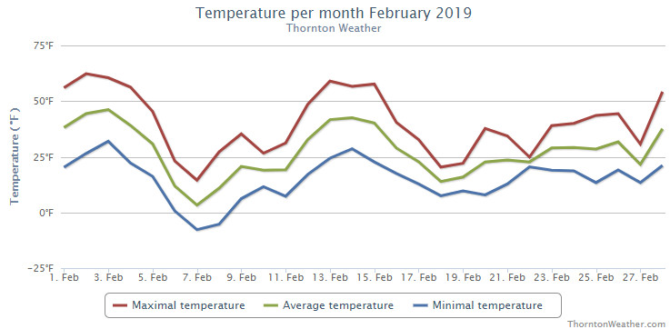
Cold and snow. Those were certainly the operative words for the month of February 19. Thornton recorded its coldest February in the past 12 years and its snowiest month overall since March 2016.
Mild temperatures started things off for the first four days of the month and fooled us into thinking of an early spring. Those dreams were soon crushed though as the first extended period of below normal temperatures arrived on the 6th. Six straight days of below normal temperatures then arrived as did our first shot of snow for the month.
We rebounded briefly for a four day period from the 12th to the 15th with mild temperatures. Once again though, the mercury plunged delivering 13 straight days of below normal temperatures and five days of measurable snowfall.
Thornton recorded an average temperature for the month of 26.3 degrees. This was our coldest February since ThorntonWeather.com came online in 2007 – by more than two degrees. Out at Denver International Airport where the Mile High City’s official readings are taken it was slightly warmer with an average of 28.0 degrees. Both were well below Denver’s long term February average of 32.5 degrees for February.
While certainly cold, neither average reading for the month could crack Denver’s list of top 10 coldest Februarys.
Thornton saw its warmest mercury reading for the month of 62.3 degrees on the second. Its coldest reading of -7.7 degrees came on the 7th of the month. Denver saw a maximum of 65 degrees on the 3rd and its low of -11 degrees on the 7th.
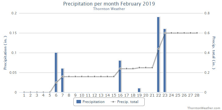
February is usually a dry month with Denver averaging 0.37 inches of liquid precipitation. Thornton recorded 0.60 inches this year while Denver saw 0.72 inches.
Similarly, snow was a good bit above normal for February as well. Thornton saw 11.2 inches of the white stuff while out at the airport 13.4 inches was recorded.
Thornton, Colorado’s temperature summary for February 2019. (ThorntonWeather.com)Thornton, Colorado’s precipitation summary for February 2019. (ThorntonWeather.com)
CLIMATE REPORT
NATIONAL WEATHER SERVICE DENVER/BOULDER CO
555 AM MST FRI MAR 1 2019

...................................

...THE DENVER CO CLIMATE SUMMARY FOR THE MONTH OF FEBRUARY 2019...

CLIMATE NORMAL PERIOD 1981 TO 2010
CLIMATE RECORD PERIOD 1872 TO 2019

WEATHER         OBSERVED          NORMAL  DEPART  LAST YEAR`S
                 VALUE   DATE(S)  VALUE   FROM    VALUE  DATE(S)
                                          NORMAL
................................................................
TEMPERATURE (F)
RECORD
 HIGH              80   02/10/2017
 LOW              -25   02/01/1951
                        02/08/1936
HIGHEST            65   02/03
LOWEST            -11   02/07
AVG. MAXIMUM     40.8              46.2    -5.4     44.4
AVG. MINIMUM     15.3              18.9    -3.6     15.4
MEAN             28.0              32.5    -4.5     29.9
DAYS MAX >= 90      0               0.0     0.0        0
DAYS MAX <= 32      8               3.9     4.1        6
DAYS MIN <= 32     26              26.9    -0.9       26
DAYS MIN <= 0       3               1.3     1.7        3

PRECIPITATION (INCHES)
RECORD
 MAXIMUM         2.01   1934
 MINIMUM         0.01   1970
TOTALS           0.72              0.37    0.35     0.31
DAILY AVG.       0.03              0.01    0.02     0.01
DAYS >= .01         6               5.3     0.7        5
DAYS >= .10         3               0.7     2.3        2
DAYS >= .50         0               0.0     0.0        0
DAYS >= 1.00        0               0.0     0.0        0
GREATEST
 24 HR. TOTAL    0.41   02/22

             OBSERVED            NORMAL   DEPART   LAST YEAR`S
SNOWFALL (INCHES)
TOTAL            13.4               5.7      7.7     6.2
RECORD FEB       22.4   2015
SEASON TOTAL     27.8              35.2

DEGREE_DAYS
HEATING TOTAL    1029               908     121      975
 SINCE 7/1       4417              4439     -22     4057
COOLING TOTAL       0                 0       0        0
 SINCE 1/1          0                 0       0        0

FREEZE DATES
RECORD
 EARLIEST     09/08/1962
 LATEST       06/08/2007
EARLIEST                        10/07
LATEST                          05/05
.................................................................

WIND (MPH)
AVERAGE WIND SPEED              9.5
RESULTANT WIND SPEED/DIRECTION   1/176
HIGHEST WIND SPEED/DIRECTION    35/060    DATE  02/14
HIGHEST GUST SPEED/DIRECTION    42/070    DATE  02/14

SKY COVER
POSSIBLE SUNSHINE (PERCENT)   MM
AVERAGE SKY COVER           0.60
NUMBER OF DAYS FAIR            3
NUMBER OF DAYS PC             20
NUMBER OF DAYS CLOUDY          5

AVERAGE RH (PERCENT)     66

WEATHER CONDITIONS. NUMBER OF DAYS WITH
THUNDER        0   FREEZING RAIN    0      LIGHT SNOW    14
MIXED PRECIP   0   LGT FR RAIN      0      ICE PELLETS    0
HEAVY RAIN     0   HAIL             0      FOG           17
RAIN           0   HEAVY SNOW       2      HEAVY FOG     11
LIGHT RAIN     0   MODERATE SNOW    3      HAZE           8

-  INDICATES NEGATIVE NUMBERS.
R  INDICATES RECORD WAS SET OR TIED.
MM INDICATES DATA IS MISSING.
T  INDICATES TRACE AMOUNT.
February 4, 2019 – A bison and bird boop noses on a mild winter day. (Jessica Fey)
February signifies the start of the climb toward warmer temperatures for the year. Cold and snow though do intrude but, coupled with milder conditions, there are lots of photo opportunities as can be seen in our monthly slideshow.
The month is one of our least snowiest of the year but it isn’t unusual to see the landscape blanketed in white. Warming temperatures through the month can bring the onset of spring fever and gives residents the opportunity to enjoy some prolonged time outdoors on the mild days.
Cold or mild, snowy or dry, our scenery is almost always gorgeous – and photo worthy.
Slideshow updated February 27, 2019
To learn more about how to send your photo to us for inclusion in the slideshow, see below the slideshow.
Showcasing images captured by ThorntonWeather.com readers as well as some of our own, our monthly slideshow covers the entire gamut of weather-related imagery.
Sunsets, sunrises, wildlife and of course every type of weather condition are vividly depicted in images captured from yours and our cameras.
[flickr_set id=”72157676280611747″]
What is missing in the slideshow above? Your photo!
Our monthly photo slideshow is going to feature images that we have taken but more importantly images that you have captured. The photos can be of anything even remotely weather-related.
Landscapes, current conditions, wildlife, pets, kids. Whimsical, newsy, artsy. Taken at the zoo, some other area attraction, a local park, a national park or your backyard. You name it, we want to see and share it!
Images can be taken in Thornton, Denver or anywhere across the extraordinary Centennial State. We’ll even take some from out of state if we can tie it to Colorado somehow.
We’ll keep the criteria very open to interpretation with just about any image eligible to be shown in our slideshows.
What do you win for having your image in our slideshow? We are just a ‘mom and pop’ outfit and make no money from our site so we really don’t have the means to provide prizes. However you will have our undying gratitude and the satisfaction that your images are shared on the most popular website in Thornton.
To share you images with us and get them included in the slideshow just email them to us or share them with ThorntonWeather.com on any of the various social media outlets. Links are provided below.
February in Colorado typically brings to an end an extended period when average temperatures are at their lowest. Winter begins to loosen its grip and temperatures get warmer but precipitation is not a particularly common event during the month.
Thus far our snow season has been relatively dismal with the seasonal total in Thornton more than 10 inches below average. In the high country, the snowpack is not faring much better. February is only our sixth snowiest month so we may not see much snowfall for the balance of the month.
Temperatures however do usually see a nice rebound during the month. Average high temperatures climb from an average of 44 degrees at the start to 50 degrees by the end of February.
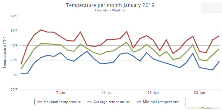
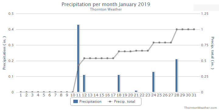
Finally! Our winter thus far had been quite dry so seeing some precipitation in January was a very welcome change. Temperatures were just a bit above normal.
Overall, the month was short on any sort of real weather drama with no major storms or particularly notable temperature extremes. However, a series of storm systems did give us a bit of a roller coaster of weather with five different snow events over the month.
January started out with a very cold New Year’s Day but soon saw warmer temperatures arrive. Our first snow came on the 11th and 12th. This was followed by some smaller events and finally our biggest snowfall of the month on the 28th.
Thornton’s average temperature for the month came in at 31.3 degrees. This was a bit warmer than Denver’s long term overage for January of 30.7 degrees. Out at DIA where Denver’s official readings are taken, it was a bit warmer with an average of 32.0 degrees.
Our mercury readings ranged from a low of 2.2 degrees on the 1st and the 2nd to a high of 61.1 degrees a few days later on the 4th. Denver’s lowest reading was 5 degrees below zero on the first and its warmest of 62 degrees came on the 4th.
In terms of precipitation, Denver averages 0.41 inches of liquid precipitation during January. Thornton easily bested that with an even 1 inch in our bucket. Denver was above average as well with 0.75 inches.
Snowfall in Thornton saw above normal levels with a total for the month of 10.9 inches. Denver, as usual, lagged with 6.2 inches of the white stuff. The 30 year average for Denver for January is 7.0 inches.
Thornton, Colorado’s January 2019 temperature summary. (ThorntonWeather.com)Thornton, Colorado’s January 2019 precipitation summary. (ThorntonWeather.com)
CLIMATE REPORT
NATIONAL WEATHER SERVICE DENVER/BOULDER CO
1026 AM MST FRI FEB 1 2019

...................................

...THE DENVER CO CLIMATE SUMMARY FOR THE MONTH OF JANUARY 2019...

CLIMATE NORMAL PERIOD 1981 TO 2010
CLIMATE RECORD PERIOD 1872 TO 2019

WEATHER         OBSERVED          NORMAL  DEPART  LAST YEAR`S
                 VALUE   DATE(S)  VALUE   FROM    VALUE  DATE(S)
                                          NORMAL
................................................................
TEMPERATURE (F)
RECORD
 HIGH              76   01/27/1888
 LOW              -29   01/09/1875
HIGHEST            62   01/04        76     -14       68  01/09
LOWEST             -5   01/01       -29      24       -4  01/16
AVG. MAXIMUM     44.6              44.0     0.6     49.2
AVG. MINIMUM     19.5              17.4     2.1     20.1
MEAN             32.0              30.7     1.3     34.7
DAYS MAX >= 90      0               0.0     0.0        0
DAYS MAX <= 32      6               5.5     0.5        3
DAYS MIN <= 32     29              29.4    -0.4       28
DAYS MIN <= 0       1               1.7    -0.7        2

PRECIPITATION (INCHES)
RECORD
 MAXIMUM         2.35   1883
 MINIMUM         0.01   1933
                        1934
                        1952
TOTALS           0.75              0.41    0.34     0.54
DAILY AVG.       0.02              0.01    0.01     0.02
DAYS >= .01         6               4.1     1.9        5
DAYS >= .10         2               0.9     1.1        2
DAYS >= .50         0               0.0     0.0        0
DAYS >= 1.00        0               0.0     0.0        0
GREATEST
 24 HR. TOTAL    0.45   01/11 TO 01/11           01/21 TO 01/21

OBSERVED          NORMAL  DEPART  LAST YEAR`S

SNOWFALL (INCHES)
TOTALS            6.2               7.0
RECORD           24.3  1992

DEGREE_DAYS
HEATING TOTAL    1016              1063     -47      932
 SINCE 7/1       3388              3531    -143     3082
COOLING TOTAL       0                 0       0        0
 SINCE 1/1          0                 0       0        0

FREEZE DATES
RECORD
 EARLIEST     09/08/1962
 LATEST       06/08/2007
EARLIEST                        10/07
LATEST                          05/05
.................................................................

WIND (MPH)
AVERAGE WIND SPEED              9.9
RESULTANT WIND SPEED/DIRECTION   4/214
HIGHEST WIND SPEED/DIRECTION    40/290    DATE  01/07
HIGHEST GUST SPEED/DIRECTION    54/350    DATE  01/22

SKY COVER
POSSIBLE SUNSHINE (PERCENT)   MM
AVERAGE SKY COVER           0.50
NUMBER OF DAYS FAIR           10
NUMBER OF DAYS PC             17
NUMBER OF DAYS CLOUDY          4

AVERAGE RH (PERCENT)     58


-  INDICATES NEGATIVE NUMBERS.
R  INDICATES RECORD WAS SET OR TIED.
MM INDICATES DATA IS MISSING.
T  INDICATES TRACE AMOUNT.
Weather, natural disasters & climate news and information.
 April marks a transition between winter and summer for most of the country but for Denver it is especially true as we can see a stunning variety of weather.
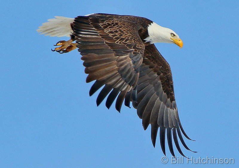
 Today, March 12, 2019, we saw our warmest temperatures in more than a month. Tomorrow, we are expecting a significant storm that may bring blizzard conditions. That is springtime in Colorado!


 February in Colorado typically brings to an end an extended period when average temperatures are at their lowest. Winter begins to loosen its grip and temperatures get warmer but precipitation is not a particularly common event during the month.