
 The storm for today didn’t quite set up as expected so its arrival was delayed and we aren’t expecting quite as much out of it at this point. At this time Thornton is seeing primarily rain showers with a few snow flakes mixed in. That rain and snow mix will continue off and on throughout the day and we could see some minor accumulations of snow on grassy areas but that will melt quickly. The weekend is still looking to be great with temperatures slightly above normal getting into the low 60’s.
Category Archives: Thornton Weather
Seasonal Wednesday, Changes Arrive at Night
Wednesday should be a nice day with temperatures right around the average of 57 degrees. Change is in the air though as before midnight we should start seeing rain which will turn to snow as the temperature drops overnight. As Thursday dawns, we’ll have wet conditions with snow showers for a good part of the daylight hours and a high of around 40. Total accumulations for the event will range from an inch to three inches but with as warm as it has been the snow won’t stick to much beyond some on the grassy areas.
Friday and into the weekend look for seasonal temperatures and maybe above the average. All in all it should be a nice weekend. The first part of next week is still a bit muddled between the models with some showing a chance for precipitation on Monday and Tuesday. Stay tuned for more information as it gets closer.
April Weather Preview – Something for Everyone
 April marks a transition between winter and summer for most of the country but for Denver it is especially true as we can see a stunning variety of weather. The proverbial April showers are certainly a possibility for Denver. Snow? Tornadoes? Thunderstorms? You bet – all can happen! For good measure throw in a chance for hail and even dust storms and April gives every type of weather condition you could like – or hate. Click here to read our April 2008 weather preview.
Surprise Snow on Easter Eve
 Last night / this morning we had a bit of a surprise as the forecasted snow that was only supposed to amount to 1/2 inch quickly turned into 3.7 inches on the ground early this morning. Yesterday afternoon and early evening we started observing some upslope conditions with strong winds from the northeast and begain wondering if the passing front could bring more than forecast. The snow started falling in earnest around 8:00pm, tapered off around 9:30 then at 12:30 this morning more started falling. All in all a pleasant surprise.
For Easter morning things will be a bit chilly, particularly for those heading to sunrise services. Sunrise is at 6:57am and in Thornton at that time the mercury will be a mere 23 degrees. We’ll have clear skies today though and warm up pretty quickly to 43 by noon as we head for a high of 51. For the first part of the week we will see above normal temperatures in the upper 60’s Monday through Wednesday which is great for those on Spring Break this week.
We here at ThorntonWeather.com wish you and yours a happy and blessed Easter!
NOAA: Increased Flood Risk, Minimal Drought
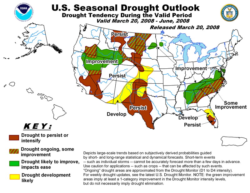
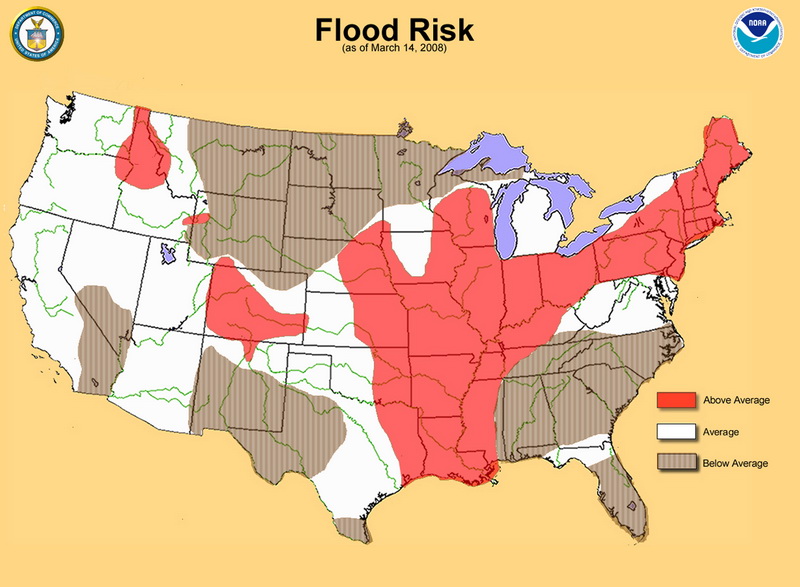
Yesterday NOAA released its spring drought and flood risk predictions and in it are some good and bad news for Colorado.
 First, the good news. With the extraordinary amount of snow the mountains have experienced this winter, the chances of drought are negligible for most of the state. The southeastern corner of Colorado however could see some risk.
Second, the bad news. With all that snow comes a risk of flooding. The danger could be especially great if we experience a warmer than normal spring and the mountain runoff occurs too quickly. Most of the state, with the exception of the northeast corner, runs above normal risks of flooding this spring. Locations in the mountains of Colorado have 150 to 200 percent of average water contained in snowpack leading to a higher than normal flood potential. Flooding is the number one weather killer in the country so everyone needs to be aware of the dangers this presents!
For more information, please see NOAA’s report here.
NWS Storm Spotter Training in March & April
 Updated 3/21 @ 9:30am – ThorntonWeather.com attended the recent training in Westminster and found it to be very worthwhile. Most of the topics covered related to severe thunderstorms, how to recognize the various types, the potential for tornadoes, and more. If you are interested in attending one of these sessions, please follow the link below. There are more sessions in the coming weeks in the north metro area.
3/17/08 @ 12:56pm – The National Weather Service will be conducting storm spotter training this Wednesday and Thursday at Front Range Community College. The Colorado All-Season Spotter Team (CAST) is a volunteer spotter network which provides real-time weather information year round to forecasters at the National Weather Service in Boulder, Colorado.
These are great sessions for anyone wanting to learn more about the severe weather we experience in Colorado. All training is free. Topics include:
To learn more about the program, see here: http://www.crh.noaa.gov/bou/awebphp/spotter.php
To view more information on this week’s training as well as future dates, see here: http://www.crh.noaa.gov/bou/?n=spot_training
Heavy Snow Warning Cancelled – Storm Recap
 Updated Monday, 3/17, 9:50am – The National Weather Service has cancelled the Heavy Snow Warning for the Denver metro area. Light snow early this morning should come to an end in most areas by late this morning and little additional snow accumulation is anticipated. We should see gradual warming with dry and seasonal temperatures at least until Friday.
Updated Monday, 3/17, 6:00am, Heavy Snow Warning Remains in Effect – Well, thus far the storm hasn’t quite shaped up as it was expected to, at least in the Denver metro area. The one component that is really missing for heavy snowfall is a good, strong upslope wind. Upslope winds have a northeasterly / easterly component and are what typically is required for us to see big snows and that just hasn’t happened – at least not enough of one. Things started out strong yesterday evening with some good snow falling around 8:00pm but it didn’t last long.
Western Kansas on the other hand appears to be bearing the brunt of the storm with a mix of blowing snow and thunderstorms. Indeed, our lightning detector was picking up a number of strikes out there during the 5:00am hour although that has since dissipated.
Looking at the rest of today, we do still remain under a Heavy Snow Warning until 3:00pm although if things don’t change, that could be lifted sooner. Radar does show moisture coming up from the south of the metro area and forecasts still call for an additional 3 to 5 inches possible this morning. However, with the temperatures staying near freezing, much of that will melt rather than accumulate.
Updated 3/16, 5:15pm – It is looking more and more like this storm will be a reality. The National Weather Service has upgraded the advisory to a Heavy Snow Warning that goes into effect at midnight tonight and runs through 3:00pm tomorrow. Current projections are still a bit flakey and show that we will receive anywhere from 4 to 12 inches of snow by the time the storm moves out tomorrow afternoon. As is typical in Colorado and especially with spring storms, we could even see sunshine by the end of the day tomorrow.
A heavy snow warning means severe winter weather conditions are expected or occurring. Significant amounts of snow are forecast that will make travel dangerous if not impossible. Only travel in an emergency. If you must…keep an extra flashlight…food…and water in your vehicle in case of an emergency.
3/16/08, 4:27am, Snow Last Night, Heavy Snow Warning In Effect For Tonight – Thornton woke up to a bit of a surprise this morning with some of the white stuff on the ground – just shy of half an inch at ThorntonWeather.com. The forecast did say there was a chance but it was pretty slim so it wasn’t really expected. It is a typical spring snow with lots of good moisture in it so it is welcome. We should be mostly dry for most of the daylight hours today but the structure of the system is such that some thunder could be heard today – a bit of a herald of the spring thunderstorms that will be coming soon. Heading into late afternoon and this evening things will change.
The Pacific storm we have been waiting for is on its way and the National Weather Service has issued a Winter Storm Watchthat goes into effect late tonight and runs through Monday morning. The track of this system is still a bit uncertain so the forecasts and models are hedging their bets a bit. 🙂 Current models are across the board for precipitation totals and locations so it is tough to say what we are going to end up with. At the current time we would expect Thornton to see 3 to 7 inches of snow by the time the storm moves out tomorrow.
Remember that a Winter Storm Watch means there is a potential for a hazardous winter event in and close to our area. Significant snow accumulations may occur that could impact travel. Tomorrow morning’s commute could be a bit ugly so plan on leaving for work early.
Flaky Weather Ahead
Colorado in the spring! Quite an array of weather across the state ahead for the coming days. The northern and central mountains are getting pounded with snow where Winter Storm Warnings are in effect through Friday night. One to two feet of snow is expected up there as our record snowpack continues to build.
On the Front Range, while the statewide snowpack is still well above-average, Denver is about 5 inches behind for the seasonal winter average and about 9 inches below the monthly average. However, we have a pretty active weather pattern expected for the next week that could eat away at that deficit. March is usually our snowiest month so the potential is there for some good storms in the coming weeks.
Scattered rain and snow showers are possible throughout today and this weekend. The big storm we were hoping to see Sunday night and into Monday looks to be pushing south into New Mexico but will cause us to be a bit unsettled through Tuesday at least. Stay tuned to ThorntonWeather.com for the latest!
Beautiful Tuesday, Cooler Wednesday, Big Snow Monday?
 We’re in the typical rollercoaster weather pattern that we usually see in the spring. Tuesday was beautiful with a high of 68 degrees in Thornton. Today will be a bit cooler as we reach 62 or so and that cooling trend should continue into the weekend. A small disturbance could bring some minor snow accumulations to the area on Friday.
Looking a bit further ahead, big changes could be in store for Sunday night and into Monday. We are currently tracking a major Pacific storm system that is working its way west and if it tracks over the state, significant snowfall could result. This far out the models are pretty inconsistent – some show it hitting us, others show it tracking much farther south into New Mexico.
Snow This Morning – Roads Very Slick
Updated 3/5/08 @ 9:12am – The snow has tapered off a bit this morning and the worst of it has subsided. However, we can expect to have flurries on and off throughout the day and into this evening with maybe an inch total accumulation in Thornton. Southern and western suburbs can expect up to three inches.
March 05, 2008 @ 06:07 – A small storm front has moved into the metro area this morning with a bit of snow and wind. This precipitation coupled with cold temperatures has made the roads quite slick. As usual, Thornton did a good job prepping their streets but our experience this morning shows other municipalities and CDOT didn’t do as good of a job. Please be careful out there!
The storm is showing a bit more of an upslope condition so we will see a bit more snow than what was originally expected. Looks for about an inch of accumulation in Thornton; more as you head further south.