Category Archives: Severe Weather

Breaking weather situation – Tornado watches and warnings posted

Live Thornton, Colorado weather image.

 Update, 5:15pm – The Tornado Watch for Adams County has been discontinued.  

We did see a number of tornadoes reported in Colorado so far today, mostly in the southeastern part of the start.  

In northeastern Colorado, two tornadoes were reported. One was reported at 3:28pm 9 miles southwest of Deer Trail in Elbert County. The second at 3:38pm two miles north of Leader in Adams County.

A very, very wet weather pattern will continue through Saturday and the chance for severe weather remains.  Be sure to stay tuned to ThorntonWeather.com! 

Update, 4:30pm: The Tornado Watch for Denver, Boulder, Broomfield and Jefferson Counties has been dropped. However, they remain in effect until 8:00pm for Adams, Arapahoe, Morgan, Washington, Weld, Elbert and Lincoln Counties. 

Two tornadoes have been reported so far. The first was at 3:28pm nine miles southwest of Deer Trail. The second was 10 minutes later at 3:38pm two miles west of Leader. No damage reports at this time. 

Original story, 3:30pm: Yesterday brought our first Severe Thunderstorm Warning of the season and today the situation gets more serious with Tornado Watches and Warnings being posted.  The severe weather threat looks to continue through the afternoon.  

A Tornado Watch has been issued for much of the Front Range including all of Adams, Arapahoe, Boulder, Broomfield, Denver, Douglas, Jefferson, Morgan, and Weld Counties.  This watch includes the entire Denver metro area including Thornton.   

Remember that a Tornado Watch means conditions are favorable for the development of severe thunderstorms producing tornadoes in and close to the watch area.   

Showers and thunderstorms are expected to continue to develop across the Front Range this afternoon and evening.  These are expected to include heavy rain, strong winds, hail and possibly hail.  Residents need to take immediate precautions to protect themselves.  

Remember, Thornton and Adams County do NOT have any type of weather warning system for residents – no sirens, text alerts, etc.  You should have your own NOAA weather radio or stay tuned to local media (and ThorntonWeather.com of course) for all the latest when severe weather strikes.  

Statewide tornado drill to occur in Colorado on Wednesday

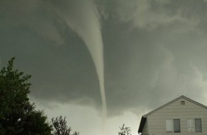
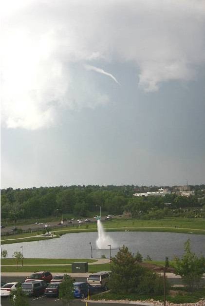
This funnel cloud was seen from the Thornton Civic Center (looking north) on June 10, 2009. Image courtesy Lisa Wilson, the City of Thornton.

If you happen to be outside or listening to broadcast media this morning, don’t be surprised to hear a tornado warning / siren. As part of Severe Weather Awareness Week, the National Weather Service will be conducting a statewide tornado test around 9:15am.

The service is urging all government agencies, schools, businesses, broadcast media and emergency management agencies to participate in this important drill.

This is a good time for citizens to ensure they are prepared and know what to do when a tornado strikes. As we saw with last year’s tornado activity and in 2008 with the Windsor tornado, twisters can and do strike the Denver area. Preparation and planning are critical to ensuring you and your family remain safe.

It is perhaps most fitting that Colorado saw its first tornado of 2010 yesterday. The twister which struck in Kit Carson County 11 miles south-southwest of Bethune caused no damage. However, it serves as an important reminder.

Will you hear tornado sirens in Thornton?  Unfortunately not.  The city does not have a warning system in place.  Find out why.

Do you know what to do when a tornado strikes?  Learn what you can do to protect you and your family here.

85 years ago today – The nation’s deadliest tornado

A Chicago Herald Examiner headline covering the Great Tri-State Tornado of 1925. (Wikipedia)  Follow the link below for images of the destruction.
A Chicago Herald Examiner headline covering the Great Tri-State Tornado of 1925. (Wikipedia) Follow the link below for images of the destruction.

News reports portray a dreary start to March 18, 1925 with heavy rain in the morning but nothing that would foretell the disaster that was to come. Before the day was over, parts of Missouri, Illinois and Indiana would be torn asunder and nearly 700 people would be dead.

Today marks the 85th anniversary of what we now call the Tri-State Tornado. The deadly twister was of the likes that had never been seen before – and hasn’t been seen since. That morning, the U.S. Weather Bureau’s forecast called for “rains and strong shifting winds.” Nothing that would indicate the horror that was to come.

The first reports of the tornado happened at 1:01pm near Ellington, Missouri. As it moved to the northeast the twister tore through the towns of Annapolis, Redford, Cornwall, Biehle, and Frohna. By the time it exited Missouri, 11 people were dead.

Illinois bore the brunt of the tornado as it continued on its deadly path. It crossed the Mississippi River and tore through Gorham, Johnston City, Murphysboro, De Soto, Hurst-Bush and a half dozen other Illinois towns. Entire towns were reduced to rubble, over a thousand people were injured and 613 people in the state were dead.

Far from over, the twister crossed into Indiana where the towns of Griffin, Owensville, and Princeton were hit. 71 people are thought to have died in the state.

The horror finally came to an end at 4:30pm, three and a half hours after it started. The tornado dissipated southwest of Petersburg, Indiana but not until after it had covered a path of at least 219 miles and left death and destruction the entire way. From southeastern Missouri, completely across southern Illinois and into southwestern Indiana, the tornado was the longest tracking twister ever recorded.

For more about the deadly tornado, maps of the path and images of the aftermath, read the complete story on the Natural Disasters Examiner.

Tornado claims the life of an elderly man in Arkansas; First tornado fatality of the year

Radar image of the tornado in White County, Arkansas. Two other twisters were reported in the state Wednesday, one that claimed the life of an elderly man. (NWS)

Tornadoes tore through Arkansas late yesterday and claimed the first tornado victim of 2010. One person was reported dead and three injured as the series of storms moved across the state.

The first twister of the night struck at 6:28pm local time in Saline County. That tornado damaged nearly two dozen homes but no injuries were reported.

The National Weather Service reported a second tornado was spawned out of a storm cell near Center Hill in White County. Nine homes were damaged and one person was injured.

The deadly twister was the third of the night which struck near Pearson in Cleburne County just after 9:00pm. Renee Preslar, spokeswoman for the Arkansas Department of Emergency Management, said that twister killed an elderly man and injured two others.

Thus far there has been a distinct lack of tornadoes reported in 2010. There were 41 twisters reported in January, slightly above the three year average for January of 37. That was followed by only one twister in February, the fewest in the month since record-keeping began in 1950.

There have been seven tornadoes reported thus far in March, all of which occurred in the last 48 hours.

Be sure to check out the Natural Disasters Examiner for all the latest on disasters from tornadoes and hurricanes to earthquakes and tsunamis!

Severe Weather Reports for Wedneday, March 10, 2010 (SPC)
Severe weather reports from the Storm Prediction Center for Wednesday, March 10, 2010

Rogue waves kill two on Mediterranean cruise

This screen capture from amateur video shows one of the massive waves crashing into the cruise ship Louis Majesty.

Massive rogue waves struck the cruise ship Louis Majesty in the Mediterranean on Wednesday killing two and injuring more than a dozen passengers. The waves, at least 25 feet in height, broke windows and flooded cabins on the ship carrying 2,000 people.

The Louis Majesty was traveling from Barcelona to Genoa on the last day of a 10-day cruise of the western Mediterranean when the waves struck. Reports indicate that three massive waves broke windshields on the front of the ship and sent water over the decks.

Two deaths were reported as a result of the waves and both died at the scene. The victims were a 52-year-old Italian man and a 69-year-old German man from North Rhine Westphalia.

Fourteen injuries were reported, most minor and none life-threatening. Two of those had serious injuries including a 62-year-old woman who broke both of her legs.

Passenger Claude Cremex of Marseille, France told the Associated Press, “It was spectacular. A lot of water came in. Many cabins were flooded.”

Exactly where the accident occurred was still unclear. Most reports said the ship was sailing near the French Mediterranean port of Marseille but others placed it off the coast of Cabo de San Sebastian, Spain near Palafrugell.

Reports are that there were high winds in the area the ship was traveling through and automated buoy data indicates significant wave action at the time. A buoy operated by Meteo France in the area recorded waves to 21 feet high and winds in excess of 40 mph.

The 680 foot ship is owned and operated by Louis Cruises and had 1,350 passengers and 580 crew members on board at the time of the accident. The nearly 41,000 ton ship is “the most stylish and biggest ship in the fleet” according to Louis Cruises.

No tornadoes reported in February for the first time on record

For the first time since at least 1950, no tornadoes were recorded during the month of February. (Chris Foltz, NOAA)

While there was plenty of notable weather last month in the United States including the severe winter storms in the northeast, tornadoes were not one weather phenomena anyone had to worry about.

According to the National Weather Service, there were no twisters reported during February 2010 – the first time since record keeping began in 1950 that February did not have any. The previous low number of tornadoes in February was 2 in 2002.

Harold Brooks, a meteorologist with the National Severe Storms Laboratory, said the last time the United States went a calendar month without a tornado was January 2003. Through yesterday it has been 36 days since the last twister struck on the 24th of January in Tennessee.

Brooks cautions against reading too much into the statistic. He said it tells us, “Somewhere between a little and nothing at all.”

Most years that start out slow in terms of tornado events end average or below average Brooks said. However, he also points to 2003 when the year started out 45 days without a tornado but by the middle of May the season was above normal.

For the complete story including what Dr. Greg Forbes of the Weather Channel had to say, please check out the rest of the story on the Denver Weather Examiner.

2010 storm spotter training dates announced

Last year's "Summer of Storms" should serve as a reminder of the severe weather threat in Denver.

Remember last year’s “Summer of Storms” that saw a seemingly endless parade of hail, funnel clouds and tornadoes visit the Front Range?  The severe weather threat in Colorado is real and it can turn deadly in an instant. 

Education is key to knowing how to protect you and your family.  Whether you want to be an official storm spotter or maybe just want to learn more about severe weather, storm spotter training can provide you an incredible opportunity to learn. 

The National Weather Service Denver / Boulder office has announced a series of storm spotter training dates for Colorado for the 2010 season. 

The storm spotter program is a nationwide program with more than 280,000 trained spotters.  These volunteers report weather hazards to their local National Weather Service office providing vital information when severe strikes.  Data from spotters include severe wind, rain, snow measurements, thunderstorms and hail and of course tornadoes. 

Storm spotters are part of the ranks of citizens who form the Nation’s first line of defense against severe weather. There can be no finer reward than to know that their efforts have given communities the precious gift of time–seconds and minutes that can help save lives.

By completing one of these training classes you can become an official storm spotter.  When severe weather strikes, you can report it by calling a special toll free number or submit your report via the National Weather Service’s website.

These are great sessions for anyone wanting to learn more about the severe weather we experience in Colorado, whether you want to be an official spotter or not.  All training is free.  Topics include:

  • Basics of thunderstorm development
  • Fundamentals of storm structure
  • Identifying potential severe weather features
  • Information to report
  • How to report information
  • Basic severe weather safety

To learn more about the program, see here: http://www.crh.noaa.gov/bou/awebphp/spotter.php

Below are the dates, times and locations announced thus far.  There is one this coming weekend in north Denver, two in Westminster in March and one in Commerce City in April – all are great opportunities for Thornton residents.  Click here to go to the NWS site for the latest.

 
February, 2010 – Upcoming
Day City, State Time Location
14 Denver, CO(Denver County) 1:00pm MST note: Following National Storm Chaser conference.
There is a charge for the conference, spotter training is free.
Red Lion Hotel Central
4040 Quebec Street
Denver, CO 80216
  Contact Information: Robert.Glancy@noaa.gov
 
March, 2010 – Upcoming
Day City, State Time Location
08 Holyoke, CO(Philllips County) 10:00am MDT Phillips County Fairgrounds
Event Center
Holyoke, CO
  Contact Information: philcoadmin@pctelcom.coop
08 Julesburg, CO(Sedgwick County) 6:00pm MST Julesburg Fire Department
  Contact Information: sedgwickcooem@yahoo.com
09 Haxtun, CO(Phillips County) 6:30pm MST Haxtun Volunteer Fire Dept.
  Contact Information: jdavis@pctelcom.coop
16 Westminster, CO(Adams County) 2:30pm MDT Front Range Community College
3645 West 112th Ave.
room TBD
Westminster, CO 80031
  Contact Information: Robert.Glancy@noaa.gov
16 Westminster, CO(Adams County) 6:30pm MDT Front Range Community College
3645 West 112th Ave.
room TBD
Westminster, CO 80031
  Contact Information: Robert.Glancy@noaa.gov
29 Sterling, CO(Logan County) 6:30pm MDT Sterling Fire Department
420 Oak Street
Sterling, CO
  Contact Information: Owens@Sterlingcolo.com
31 Akron, CO(Washington County) 6:30pm MDT rescheduled…
Washington County Fairgrounds Event Center, Akron
  Contact Information: mmccaleb@co.washington.co.us
 
April, 2010 – Upcoming
Day City, State Time Location
01 Anton, CO(Washington County) 6:30pm MDT Southwest Washington VFD, Anton station
  Contact Information: mmccaleb@co.washington.co.us
06 Agate, CO(Elbert County) 6:30pm MDT Agate School.
  Contact Information: cory.stark@elbertcounty-co.gov
08 Fort Morgan, CO(Morgan County) 7:00pm MDT TBD
  Contact Information: senfante@co.morgan.co.us
15 Castle Rock, CO(Douglas County) 6:30pm MDT TBD
  Contact Information: fsantaga@dcsheriff.net
23 Commerce City, CO(Adams County) 1:00pm MDT 4201 East 72nd Avenue
Commerce City, CO
  Contact Information: RNewman@co.adams.co.us
29 Parker, CO(Douglas County) 7:00pm MDT South Metro Fire Parkglenn HQ
10235 Parkglenn Way
Room A & B
Parker, CO
  Contact Information: kc0mht@msn.com

Discovery Channel’s Storm Chasers premieres Sunday

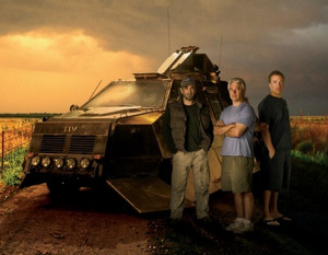
Sean Casey, Josh Wurman, Reed Timmer next to Storm Chasers vehicle, TIV2. (Discovery Channel)

Storm Chasers is the Discover Channel’s hit show that tracks a team of tornado chasers across Tornado Alley as they hunt for twisters. Entering its third season, the season premiere is this Sunday, October 18th at 8:00pm MDT.

This season the team features a number of changes over year’s past. Josh Wurman and his team of scientists manning the DOW (Doppler On Wheels) radar returns but now he is participating in the VORTEX2 project as well. Sean Casey and the TIV2 (Tornado Intercept Vehicle) return as well.

Last season’s new addition, the TornadoVideos.net team with Reed Timmer, join with an impressive new piece of hardware – the Dominator. Lastly, world renowned storm chaser Tim Samaras joins the show as he continues on his lifelong hunt and scientific quest.

Here is a preview video for the coming season.  Be sure to tune in on Sunday!

Summer 2009 in review – The summer of storms

This funnel cloud was seen from the Thornton Civic Center (looking north) on June 10th.  Image courtesy Lisa Wilson, the City of Thornton.
This funnel cloud was seen from the Thornton Civic Center (looking north) on June 10th. Image courtesy Lisa Wilson, the City of Thornton.

As summer 2009 comes to a close, it is perhaps most fitting that fall arrives with nearly winter-like weather. We ushered in the summer a month early with a record setting high temperature and soon followed that up with a near constant stream of severe weather for weeks. In fact, most of the events during what was a very active summer season actually occurred in the weeks leading up to the official start of summer.

Even though the official start of summer was a month away, May 19th seemed to be an unofficial start as the mercury climbed to 90 degrees that day setting a new record for the date. The very next day in perhaps what was a sign of things to come, a tornado touched down in Mesa County – only the ninth to strike in that county since 1950.

On May 24th, the first of many severe weather days arrived bringing rain totals of more than an inch to some areas of the Front Range and a funnel cloud over Aurora. As the afternoon progressed the severe weather continued and three tornadoes had been reported in the metro area.

After a couple weeks of relative calm, the severe weather once again appeared and on June 7th funnel clouds and tornadoes seemed to be appearing everywhere. From the north metro area in Broomfield to Aurora, most of the Front Range had some sort of direct severe weather threat. Most notably,the Southlands Shopping Center was struck by an EF1 tornado where extensive damage to the mall occurred.

There's more to this story on the Denver Weather Examiner's site!All of that was only a start to what was a very eventful summer for Thornton and Denver!  Read the rest of this story on Examiner.com!

Denver storm costs $350 million – Second most in state history

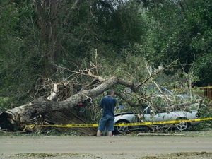
A man surveys damage to a vehicle struck by a fallen tree after last week's storms. The June 20th hail and wind storm has racked up costs of $350 million in insurance claims.  Image courtesy Becki Mullen.
A man surveys damage to a vehicle struck by a fallen tree after last week's storms. The June 20th hail and wind storm has racked up costs of $350 million in insurance claims. Image courtesy Becki Mullen.

Last week’s hail and wind storm that brought destruction to the west Denver suburbs of Wheat Ridge and Arvada caused $350 million in insured damage according to the Rocky Mountain Insurance Information Association (RMIIA).  The end result is a storm that now ranks as the second costliest in state history and adds to an already expensive summer storm season.

The July 20th storm has thus far resulted in 52,400 claims, 19,500 of which were for automobile damage and 32,900 were homeowner claims.  RMIIA says that damage would have been much higher had the storm struck during daylight hours when more people and vehicles were on the road instead of in their homes and garages. 

Massive trees were uprooted, power poles snapped, windows shattered, and automobiles dented beyond repair when the storm brought winds in excess of 60 mph and golf ball sized hail to the area.  Two tornadoes also briefly touched down near Castle Rock and Englewood although they were not responsible for significant damage.  90,000 people lost power during the storm and Xcel Energy deployed more than 200 people into the field to restore electricity. 

There's more to this story on the Denver Weather Examiner's site!For all the details, including amazing images and video of the damage, view the complete story on Examiner.com.