The storm we’ve been keeping an eye on is heading our way and there will definitely be a big change in temperatures. This will bring an end to the very mild weather we have been experiencing and by mid-day Tuesday the front will arrive and the mercury will drop quickly – expect Tuesday’s high temperature to arrive mid-morning and drop from there.
By Tuesday’s afternoon rush hour snow should be falling although unfortunately it doesn’t look like there will be a lot of accumulation. Flurries will continue through Tuesday night into Wednesday with modest accumulations. Heading into Wednesday our high temp will be near freezing and will stay there through most of the holiday weekend. Thanksgiving will definitely be a cold one and anyone heading out on “Black Friday” to get started on Christmas shopping better be bundled up!
Stay tuned to ThorntonWeather.com for more information on this developing system as it becomes available.
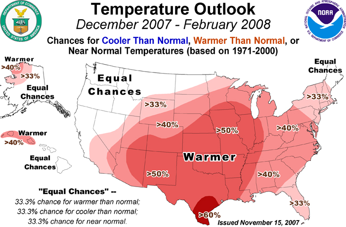
NOAA released its final 90 day winter forecast and little changed from earlier predictions. For Colorado that means the likelihood of warmer than normal temperatures, particularly in the southern part of the state. In terms of precipitation, they foresee equal chances for normal, above and below normal moisture while southern Colorado remains dry.
“Although we are expecting a warmer than normal winter, we do believe there will be fluctuations of warm weather and typical winter weather throughout the season,” said Edward O’Lenic, chief, forecast operations, NOAA Climate Prediction Center. “We encourage people to review winter weather risks for their particular area and information available online to help keep them safe when events do occur.”
The metro area is going through a bit of a dry spell with it having been 25 days (and counting) since our last measurable precipitation. Relief may be on the way toward the middle of next week. The National Weather Service’s outlook says:
“The jet stream will switch from a westerly flow to a northerly flow Tuesday. This flow will persist into next weekend. This will bring much cooler temperatures and a good chance for snow. There is still quite a bit of uncertainty when the periods of snow will occur. Currently the best chance for snow will be Tuesday night and Wednesday.“
Of course forecasting a weather event like this four or five days away is pretty hard. Current indications show the storm arriving around midday Tuesday and hanging around through Wednesday morning. Computer models are saying less than 6″ of snow is expected across northeastern Colorado while the majority of the precipitation heads southeast onto the plains. Stay tuned for more information as it gets closer!
Klaus Wolter predicts that the La Nina pattern that seems to be setting in will drive the jet stream north thus causing Colorado to stay dry. He says, “”I am very concerned that Colorado … might see regions of drought develop by spring.” To read more, click here to read the story in the Rocky Mountain News.
November is actually Denver’s second snowiest month so the potential is there for a good bit of moisture. Temperatures can vary widely with Denver having seen a record high of 80 degrees and a record low of -18. Forecast models right now show above normal temperatures can be expected for the month with an indeterminate amount of moisture. For more on what to expect and what Denver has seen in November in the past, check out the Climatological Preview for November.
Weather, natural disasters & climate news and information.

 November is actually Denver’s second snowiest month so the potential is there for a good bit of moisture. Temperatures can vary widely with Denver having seen a record high of 80 degrees and a record low of -18. Forecast models right now show above normal temperatures can be expected for the month with an indeterminate amount of moisture. For more on what to expect and what Denver has seen in November in the past, check out the