The Internet has an incredible amount of information out there. Weather websites abound, some better than others. Everyone of course knows about the local TV station websites that provide a quick, glossed over look at the weather but what if you want to know more? These five sites are great places for more in depth information.
 Weather Underground – Like many weather sites, the Weather Underground is a one stop shop for everything weather. All of the standard stuff like conditions and forecasts from around the U.S. and the globe are here. A few things set it apart from others though. First are the weather maps that you see when you visit their main page – temperature, dew point, wind, satellite, fronts and more are all easily accessible. The second and most unique feature is the network of Personal Weather Stations (PWS) that provide data to the Weather Underground. Clicking on the “Personal Weather Stations” link toward the top right of their site allows you to select a state and then view data from one of thousands of weather stations operated by weather enthusiasts. Look at the Colorado list and you will almost certainly be able to find a station within a couple of miles of your home. You can then view real time conditions for that station thus providing you with a more accurate view of the conditions where you live – not 20 miles away at Denver International Airport or downtown.
 National Weather Service (NWS) – Unbeknownst to most folks is that the United States’ government run weather service is quite unique in the world. No country has a government department with the resources of our own National Weather Service. On weather.gov you will find a dizzying array of information from weather conditions and radar to climatological and severe weather information. In terms of sheer amount of information available, it is second to none. Where it does suffer however is in usability – it just isn’t always that easy to find what you are looking for. It is there though and well worth spending some time investigating. Also be sure to check out our local Denver / Boulder Weather Forecast Office for information specific to Colorado.
 Weather Channel – By far the most “commercial” of weather websites, this is the online arm of the TV station of the same name. Surprisingly the depth of information isn’t as great as one might expect considering its name and reputation but it is still a good site to remember. I would consider this a good “consumer” weather website for someone just wanting the no frills basics without all the details. One neat new feature is the weather maps that the Weather Channel now provides via Google Maps. Click here to view them. Using this map you can zoom in on an area of the country and view current conditions. The neatest thing though is the overlays that you can add to the map including cloud cover and radar.
 National Oceanic & Atmospheric Administration (NOAA) – This government agency is a one stop shop for all things related to the climate. Like their website says, “Our reach goes from the surface of the sun to the depths of the ocean floor as we work to keep citizens informed of the changing environment around them.” NOAA operates everything from satellites that monitor the sun and the Earth from space to more terrestrial monitoring of our climate and environment. Long term forecasting and data analysis provide the public, government and researchers with information vital to understanding the world in which we live. Like many government sites, there is a ton of information here but you do have to hunt for it a bit.
 ThorntonWeather.com – Of course I have to plug my own website! There are hundreds of personal weather stations across the state and many provide their data free to the Internet public. With data from my own weather station coupled with the many freely available resources on the Internet, my website is a bit of a one stop weather information center, particularly for those living in the north metro area. Everything you need in a weather website is there – current conditions, forecasts, radar, maps, weather news, climatological information, historical data, education and even lightning detection. Be sure to check it out – you will probably be surprised just how much is readily available to a weather enthusiast! Two other metro area personal weather station websites that are run by fellow weather geeks that I help maintain are ArvadaWx.com for those on the west side of town and ReunionWeather.com for those to the northeast.

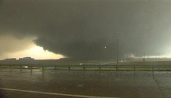 UPDATE, 1:13pm – Severe damage appears to have been caused by the first tornado to strike today. The Greeley Tribune is reporting one possible tornado death near the missile silo park near Colo. 257 near 10th Street in west Greeley. Reports are that old town Windsor has been heavily damaged.
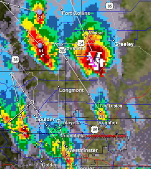 At 11:30am radar showed a tornado touching down three miles east of Milliken (about 45 miles north of Denver). The radar image at the right shows the cell in its early stages with a tornado signature. Reports indicate that there have been no injuries but officials have closed Highway 85 at Highway 60 after two semi-trailers were blown over in that area. Power is reported out in Greeley.
 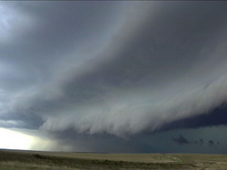 After three consecutive days with temperatures over 85, change is in the air. Low pressure is intensifying over the foothills this afternoon and as a result the chance of thunderstorms is on the increase.
 For those that have seen the
  This past weekend a deadly spate of tornadoes struck Oklahoma and Missouri, killing at least 22 people. More than a third of those died in cars despite the fact that vehicles are one of the worst possible places to be when a twister strikes.
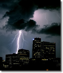 Lightning is the number two weather killer in the United States (behind floods). Here is Colorado we seem to be particularly blind to the dangers the phenomenom presents as we are ranked #2 in the U.S. for lightning related deaths. Over the years, a number of myths have developed about severe weather safety and lightning in particular. Here’s a few that you may want to keep in mind:
  The one constant about May weather is change. Colorado natives and those that have lived here long enough know that Denver and Colorado weather changes considerably throughout the year. The month of May almost seems to pack an entire year of weather conditions into 31 days. You name it, it can happen.

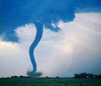
 A Red Flag Warning has been issued for most of the state as warm temperatures and low humidities have increased the danger of fires getting out of control. This was witnessed first hand last week with the four wildfires in southern Colorado that quickly got out of hand.
 Time to get outside this weekend! The forecast looks absolutely beautiful with a high of 76 expected on Saturday and 72 on Sunday. This is why we all love Colorado.