The fall colors on the Colorado Front Range are a bit of a mixed bag this year but are about as good as they will get right now. Two days after work this week I took my drone out to a couple spots to capture the scenery along the South Platte River. Sit back, make it full screen, and enjoy the view.
Category Archives: Colorado Weather
Leaf peeping 2025: When and where to see the fall colors

This time of year many folks start thinking about heading to the hills west of Denver in search of gold – fall foliage gold.
Where to go? Below are five of ThorntonWeather.com’s favorite ones near Denver – plus a few further out and some bonus ideas. After that, we will tell you where you can find a great website that provides regular updates on viewing conditions.
- Images from last year’s fall colors:
I-70 Corridor – If you’re looking for the easiest route, then this one is for you. Simply head west on I-70 about 110 miles to Avon. Between Vail and Avon, both sides of I-70 are lined beautifully with aspen.
Rocky Mountain National Park – One of the most popular summer destinations in the state is of course also a prime spot to view aspen in all their glory. Once in the park head toward Bear Lake. Glacier Gorge Junction provides a beautiful spot and you of course also get to enjoy all the splendor that Rocky Mountain National Park has to offer. Extend your viewing by taking Trail Ridge Road all the way through to the west side of the park and the Grand Lake and Granby area.
Peak to Peak Highway – This little road trip can be a dual purpose trip – gambling and fall foliage viewing! Take U.S. 6 through Clear Creek Canyon and then 119 through Blackhawk and Central City. You can of course stop there if your wallet is fat enough and donate some money to the casinos. From there continue on 119 toward Nederland. Take highway 72 toward Ward and Allenspark. There you will find more golden aspen than you can imagine, all with the Continental Divide nearby.

Poudre Valley Canyon – Heading north on I-25 take Colorado 14 west and into Poudre Canyon and Roosevelt National Forest. As you continue west you will come very near timberline as you come to Cameron Pass. Amazing views abound!
Guanella Pass – This is a nice, relatively short drive from Denver. From C470 take 85 through Bailey and Conifer, a nice drive unto itself. When you come to the town of Grant, take the Guanella Pass Scenic and Historic Byway north to Georgetown. The air is pretty thin along the way as you climb in excess of 11,500 views through the Pike and Arapahoe National Forests.
A couple other possibilities further from the Front Range:
Leadville / Aspen – From Denver take I-70 west to Copper Mountain and then Colorado 91 south over Freemont Pass to Leadville. Along the way there are plenty of viewing opportunities and Leadville is a nice little town to make a stop. From here you can take Highway 24 north back through Minturn and Vail. To extend the drive, take Highway 24 south to Colorado 82 and head toward Aspen. You can stop by the Maroon Bells in White River National Forest to view some of the most photographed mountains in Colorado.
Cottonwood Pass – From Denver take Highway 285 to Buena Vista. Head west on Main Street for seven miles then west on County Road 344 / Colorado 82. From there you start the climb up Cottonwood Pass with absolutely stunning views from the top. If you are up for it, you can continue down the west side of the pass into the Taylor Park area.
Honorable mentions worth considering:
- Boreas Pass between Breckenridge and Como (County Road 10)
- Kenosha Pass on Highway 285 between Bailey and Fairplay
- Independence Pass (Colorado 82 between Aspen and Twin Lakes)
- Colorado 103 from Evergreen to Echo Lake. Throw in a drive up Mount Evans for a bonus.
If you do head out, be sure to send us your pictures for inclusion in our monthly photo slideshows!
- Email: info@ThorntonWeather.com
- Facebook: https://www.facebook.com/ThorntonWeather
- X: @ThorntonWeather (https://twitter.com/thorntonweather)
For more information:
Farmers’ Almanac winter forecast predicts “chill, snow, repeat”

The Farmers’ Almanac released its 2025 – 2026 winter outlook and if it were to bear out, Colorado could be in for some harsh, wintry weather.
The publication portends a “very cold, snowy” winter for the north central plains. It says the region is, “set for a classic winter wonderland.”
Founded in 1818, the Farmers’ Almanac’s forecasts use a “tried-and-true formula that adapts to the mysteries of nature and the ever-changing world in which we live. The basis of our prediction method was developed by our founding editor according to correlations between celestial events, and various meteorological conditions.”
Of course, long range forecasts this far out, no matter who is making them, have to be taken with a grain of salt. However, as Thornton has seen four straight snow seasons with below normal levels of the white stuff, a change might be welcome.
National Weather Service completes damage assessments of May 18 tornadoes

The National Weather Service has completed their damage assessments of this past Sunday’s tornadoes in Arapahoe and Adams counties. The service tallied four twisters, three rated EF-2 and one EF-1.
The largest of the twisters, northeast of Bennett, hit an estimated peak wind speed of 112 mph. Its damage path was nearly five miles long and at times, 400 yards wide. It was on the ground for 15 minutes.
A second twister before that one started in Arapahoe County and ended in Adams. It saw max winds of 125 mph, a path just over 5 miles long and a maximum width of 200 yards.
Details on the twisters are:
Public Information Statement…CORRECTED
National Weather Service Denver/Boulder CO
1153 AM MDT Wed May 21 2025
…NWS Damage Survey for 05/18/25 Tornado Event…
Overview…Four tornadoes occurred just to the south and east of metro Denver in the early afternoon of Sunday, May 18th. The first tornado that produced damage in northwest Elbert County was an uncharacteristically strong landspout, as well at the last tornado that occurred northeast of Bennett. The other two tornadoes were more strongly associated with a parent thunderstorm, known as a supercell.
The following information is for four separate tornado tracks surveyed on May 19th. The first is for the initial tornado, rated EF2, in and near the Elkhorn neighborhood of extreme northwest Elbert County, Colorado. The second is an EF1 that occurred south of Manila Village. The third and fourth tornadoes were both ranked EF2. These tornadoes tracked just to the west and north of Bennett, Colorado. They were two separate tornadoes, and were both on the ground at the same time between 140 pm and 146 pm. All data is preliminary and subject to change as new information is received.
.Elkhorn Ranch…
Rating: EF2
Estimated Peak Wind: 125 mph
Path Length /statute/: 0.94 miles
Path Width /maximum/: 50 yards
Fatalities: 0
Injuries: 0
Start Date: 05/18/2025
Start Time: 01:07 PM MDT
Start Location: 6 SSW Oea Building / Elbert County / CO
Start Lat/Lon: 39.5584 / -104.6226
End Date: 05/18/2025
End Time: 01:12 PM MDT
End Location: 5 SSW Oea Building / Arapahoe County / CO
End Lat/Lon: 39.5693 / -104.6123
.Manila Rd…
Rating: EF1
Estimated Peak Wind: 95 mph
Path Length /statute/: 2.53 miles
Path Width /maximum/: 75 yards
Fatalities: 0
Injuries: 0
Start Date: 05/18/2025
Start Time: 01:23 PM MDT
Start Location: 2 NE Oea Building / Arapahoe County / CO
Start Lat/Lon: 39.6614 / -104.5519
End Date: 05/18/2025
End Time: 01:32 PM MDT
End Location: 4 SSW Manila Village / Arapahoe County / CO
End Lat/Lon: 39.6917 / -104.527
.Bennett…
Rating: EF2
Estimated Peak Wind: 125 mph
Path Length /statute/: 5.09 miles
Path Width /maximum/: 200 yards
Fatalities: 0
Injuries: 0
Start Date: 05/18/2025
Start Time: 01:30 PM MDT
Start Location: 3 SSE Manila Village / Arapahoe County / CO
Start Lat/Lon: 39.7191 / -104.4948
End Date: 05/18/2025
End Time: 01:46 PM MDT
End Location: 1 NNW Bennett / Adams County / CO
End Lat/Lon: 39.7706 / -104.4394
.NE Bennett…
Rating: EF2
Estimated Peak Wind: 112 mph
Path Length /statute/: 4.62 miles
Path Width /maximum/: 400 yards
Fatalities: 0
Injuries: 0
Start Date: 05/18/2025
Start Time: 01:40 PM MDT
Start Location: 2 NNE Bennett / Adams County / CO
Start Lat/Lon: 39.7838 / -104.4074
End Date: 05/18/2025
End Time: 01:55 PM MDT
End Location: 6 NNE Bennett / Adams County / CO
End Lat/Lon: 39.8397 / -104.379
&&
EF Scale: The Enhanced Fujita Scale classifies tornadoes into the
following categories:
EF0…..65 to 85 mph
EF1…..86 to 110 mph
EF2…..111 to 135 mph
EF3…..136 to 165 mph
EF4…..166 to 200 mph
EF5…..>200 mph
NOTE:
The information in this statement is preliminary and subject to
change pending final review of the events and publication in
NWS Storm Data.
Dashcam video captures tornado ripping apart house in Colorado
Two confirmed tornadoes struck just east of Denver Sunday. The National Weather Service has given both twisters a preliminary rating of EF2 with winds between 111 and 135mph. As many as 36 structures, a dozen of which were homes, were damaged.
Some absolutely stunning photos and videos have emerged from the event but arguably none more scary than this one. Taken by Fer Romo’s dashcam, it shows the person fleeing in a truck as the tornado in Elbert County rips about a home.
National Weather Service geographical feature map
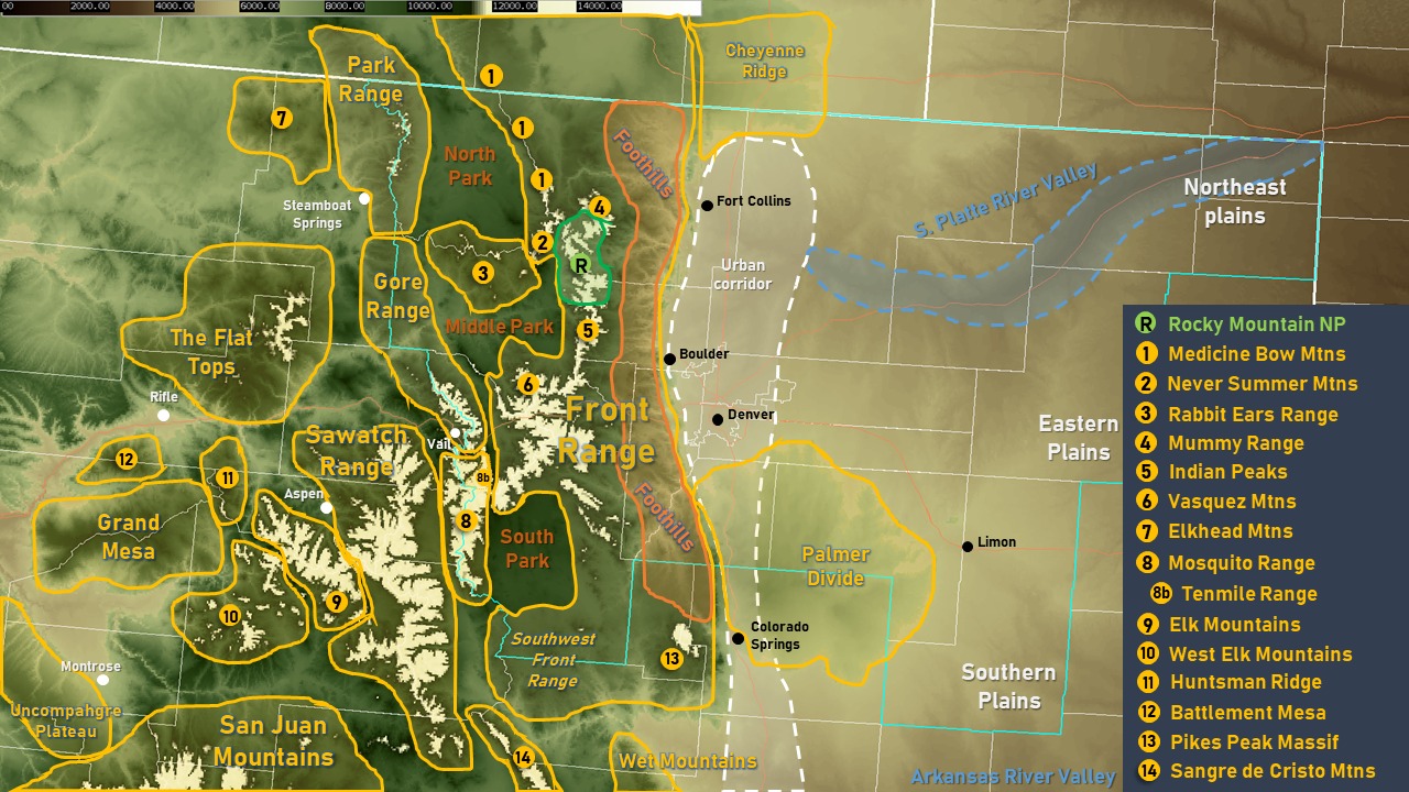
Flat Tops? Middle Park? Palmer Divide? Where the heck are those? Certainly some of the common geographical features / locations you see in a weather forecast are easily recognized but some are lesser known.
The Denver / Boulder office of the National Weather Service created a very handy map that shows where the most common geographical features are located in northeastern Colorado. It is a fantastic resource to knowing these locations. Learn them and you will be a Colorado pro in no time!
NOAA’s fall outlook predicts warmer and drier than normal conditions for Colorado

Tired of the heat of summer? Well, don’t power off that air conditioner just yet.
NOAA’s Climate Prediction Center’s autumn outlook for September, October and November, if accurate, would have us continue the above normal, drier than normal conditions of recent months.
The forecast gives above normal chances for most of the contiguous United States to see above average temperatures. For Colorado, the Four Corners region has the greatest chance at a likeliness of 60 to 70 percent. Most of the state, including the Front Range, is at a 50 to 60% chance.
In terms of precipitation, a good chunk of the nation has good chances to see below normal levels. The vast majority of Colorado is being given a 40 to 50% probability of below normal levels.

100 years ago – Colorado’s deadliest tornado on record
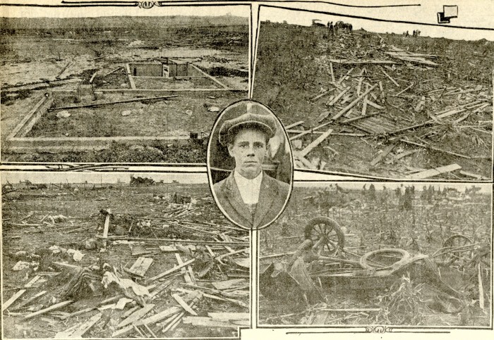
The National Weather Service did a fantastic writeup about this devastating event on August 10, 1924 that claimed the lives of 11 people, 9 of which were children. It is a fascinating read. Check it out here.
From Microsoft Copilot:
The 1924 Thurman Tornado is the deadliest tornado in Colorado’s history. Here are some key details:
- Date and Location: The tornado struck on August 10, 1924, in Thurman, Colorado, a small community in Washington County12.
- Intensity: It was rated an F4 tornado, with winds exceeding 210 mph (340 km/h)3.
- Path and Damage: The tornado traveled approximately 8 miles with a width of 200 yards, demolishing nearly every building in its path12.
- Casualties: The tornado killed 11 people, including 9 children, and injured 7 others123. Most of the fatalities occurred at the farm of Henry Kuhns, where a gathering of 27 people was taking place12.
The tornado remains a significant event in Colorado’s weather history due to its devastating impact on the small community.
Winter Weather Preparedness Week recap
As we have talked about this week, winter weather can be dangerous and downright deadly. However, being prepared helps to ensure that you and your family remain safe when the snow starts to fly or other winter weather conditions occur.
It is very easy to ignore the dangers of weather – no matter the season – and find yourself saying, “I wish I would have….” Now is the time to think about how you can prepare for these conditions, before it is too late and you find yourself wishing you had.
In this sixth and final message in a series on Winter Weather Preparedness from the National Weather Service, ThorntonWeather.com reviews the topics we covered this week and directs you to the previous articles and other resources to help you get ready.
PUBLIC INFORMATION STATEMENT
NATIONAL WEATHER SERVICE BOULDER CO
600 AM MDT SAT OCT 22 2022
Enjoy the great outdoors in Colorado this winter season, but watch the weather.
The National Weather Service issues a variety of winter weather, outlooks, watches, warnings, and advisories, covered earlier during this Winter Weather Preparedness Week. Safety tips were also passed along.
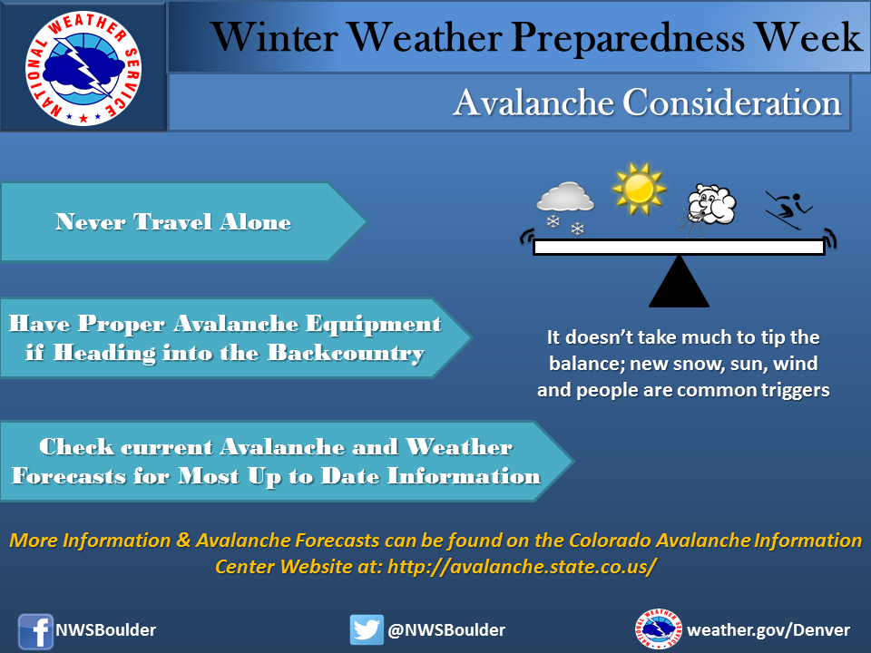
Avalanche safety – Be prepared or die
")
As snow starts to fall, many Coloradoans and out of state visitors will take advantage of it and head to the mountains for a variety of outdoor activities. Whether skiing, snowshoeing, or hiking, anyone who spends time outdoors in the high country needs to be aware of the danger avalanches present. On average six people die in Colorado every year from avalanches and being prepared is an essential survival skill.
In this fifth in a series on Winter Weather Preparedness from the National Weather Service, ThorntonWeather.com helps you understand avalanches, where they occur, how to protect yourself and where to go for more information. If you are headed to the high country, be sure to check out our Avalanche Information & Forecast page.
PUBLIC INFORMATION STATEMENT
NATIONAL WEATHER SERVICE DENVER CO
600 AM MDT FRI OCT 21 2022
Avalanches – Are you prepared?
Thousands of avalanches occur each winter in the mountains of Colorado. With the enormous popularity of winter sports in Colorado, this poses a risk to skiers, snowboarders, snowmobilers, and people traveling in the backcountry. On average 6 people die in Avalanches in the state of Colorado every year. Anyone who travels into the high country in the winter should be prepared for avalanches And know how to avoid them.
The most important thing to know is how to get information on current avalanche conditions. Check the Colorado Avalanche Information Center website at http://avalanche.state.co.us/ for the current avalanche forecast and the National Weather Service website http://www.weather.gov for the current weather forecast in your area. Knowing the current and future conditions will help you make good decisions in the backcountry.
Winter Weather Education Series
| Intro | Winter Weather Preparedness Week |
| Part 1 | Winter travel safety |
| Part 2 | Watches…warnings…and advisories |
| Part 3 | High winds |
| Part 4 | Wind chill temperatures and hypothermia |
| Part 5 | Avalanche safety |
| Review | Winter Weather Preparedness Week review |
A little information about avalanche safety can go a long way. Most avalanches occur during or just after snowstorms on a slopes between 30 to 45 degrees. A significant snowfall may result in an unstable snowpack. By waiting at least 36 hours after a big snow or wind storm before you go into the mountains the Snow may become more stable and less likely to avalanche. If you stay in valleys away from avalanche chutes, in stands of dense trees, or on gentle slopes you can decrease the risk of being caught in an avalanche.
If you are a skier or snowboarder at a commercial ski area the risk from avalanches is lower than in the backcountry. Ski patrols work to reduce the chance of an avalanche on open slopes. Respect the rules of the ski area, stay on open slopes, and do not stray out of bounds or into closed areas. The avalanche risk is higher outside of the ski area boundaries.
If you want to enjoy the great outdoors in areas prone to avalanches…You can reduce the danger by following a few simple rules:
- Check the current avalanche forecast to get information on current and forecast avalanche conditions. Also check the latest weather forecast to see if conditions are likely to change while you are in the backcountry.
- Never travel alone. Always have one or more companions. Even small avalanches can be fatal. If you are alone and get trapped, you may not be found until spring.
- If crossing a slope that may be prone to avalanches, do it one person at a time. You want to minimize the impact on your party if an avalanche is accidentally released.
- In avalanche country, all members of your party should carry avalanche rescue equipment including an avalanche beacon, shovel and probe pole. This increases your chances of a successful rescue and finding your friends alive.
Avalanche conditions in Colorado are monitored and forecasted by the Colorado Avalanche Information Center, CAIC. You can get more information on avalanches, avalanche forecasts, avalanchesafety and request a safety class from CAIC. Go to their website…Http://www.colorado.gov/avalanche or call the center at 303-499-9650.
Winter Weather Preparedness Week continues through Saturday. Now is the time to get prepared for winter so you can safely enjoy the outdoors and travel safely when the snow flies.