October and November brought Thornton cooler than normal temperatures and a good bit more snow than usual. What will December hold for us?
The month of December brings with it the official start of winter and oftentimes, colder and snowier weather conditions.
It however can also offer unseasonably warm temperatures and bone dry conditions. Given our recent mild and dry weather, we are certainly hoping for a change in the coming month.
Overall December’s monthly mean temperature of 30.0 degrees (1981 – 2010 averages) makes it our coldest month. Snow is always on everyone’s mind this time of year but December is only our 3rd snowiest month behind March and November with an average of 8.5 inches of the white stuff.
We knew today would be the warmest day of the weekend and not only did that hold true, it was a record setting performance.
As measured at DIA, Denver’s high temperature today reached 77 degrees (as of this writing). That bested the record high temperature for November 9th of 76 degrees set in 1927.
Here in Thornton, we were a bit warmer with a high of 79 degrees.
The weather during the month of November in Denver metro area can offer just about anything. While it is normally a quiet month, it can be prone to extremes.
November has historically been one of Denver’s snowiest months and major snowstorms are not entirely uncommon. However conditions can also be quite dry.
Temperatures during the month continue to cool as we get closer to winter and by the end of the month the low temperatures routinely dip to 20 degrees or below. At times it can in fact bring conditions more like what we see in January.
There is little doubt that when folks’ memories go back October 2019’s weather, they will remember the snow and even more so, the cold. Numerous cold temperature records were broken and the month ended up as one of the coldest Octobers on record.
Things started off cool for the first few days and a bit of precipitation. We then warmed up and dried out, seeing our warmest temperatures of the month on the 7th, 8th and 9th. From there, it was mostly downhill.
The evening of the 9th saw a powerful storm system and cold front move across northeastern Colorado. Temperatures plummeted and we saw our first snowfall of the season. Denver officially saw a 70 degree temperature change from the 9th to the 10th, tying the period for the second largest two-day temperature swing in Denver history.
High pressure returned on the 12th and we warmed up and dried out again. Cool but non-dramatic conditions arrived for the 18th through the 23rd. We then saw our second snowfall on the 24th of the month.
A brief rebound saw us warm up and enjoy a day of warmer than normal temperatures on the 26th. Once again, Mother Nature dropped the hammer with cold and snow returning on the 27th. The final five days of the month saw us receive two shots of snow and temperatures more akin to what we would expect to see in January.
Overall, Thornton’s average temperature for the month was 42.8 degrees. This was far below the long term Denver average for October of 50.9 degrees and was Thornton’s second coldest October since ThorntonWeather.com came online in the fall of 2006.
Out at Denver International Airport where the Mile High City’s official measurements are taken, it was slightly warmer with an average of 43.7 degrees. That made the month the fourth coldest October in Denver weather history.
Denver saw six cold weather daily temperature records fall. Among them were a record low of 13 degrees on the 10th, a record low on the 11th, record low maximums on the 28th and the 29th, and then two more record low temperatures on the 30th and 31st.
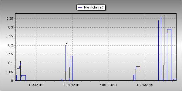
In terms of precipitation, Denver averages 1.02 inches of liquid during the month of October. Thornton bested that handily with 1.54 inches in our rain bucket. At DIA, it was drier with only 0.91 inches officially.
Snow was abundant in Thornton and Denver. Thornton received 17.6 inches of the white stuff while Denver came in at 12.5 inches. The Denver measurement made the month the 12th snowiest in Denver weather history.
Thornton, Colorado’s October 2019 Temperature Summary.Thornton, Colorado’s October 2019 Precipitation Summary.
CLIMATE REPORT
NATIONAL WEATHER SERVICE DENVER/BOULDER CO
230 PM MDT FRI NOV 1 2019

...................................

...THE DENVER CO CLIMATE SUMMARY FOR THE MONTH OF OCTOBER 2019...

CLIMATE NORMAL PERIOD 1981 TO 2010
CLIMATE RECORD PERIOD 1872 TO 2019

WEATHER         OBSERVED          NORMAL  DEPART  LAST YEAR`S
                 VALUE   DATE(S)  VALUE   FROM    VALUE  DATE(S)
                                          NORMAL
................................................................
TEMPERATURE (F)
RECORD
 HIGH              90   10/01/1892
 LOW               -2   10/29/1917
HIGHEST            83   10/09        83       0       86  10/03
LOWEST              3   10/30        22     -19       18  10/15
AVG. MAXIMUM     58.5              65.3    -6.8     61.5
AVG. MINIMUM     28.9              36.6    -7.7     36.8
MEAN             43.7              50.9    -7.2     49.2
DAYS MAX >= 90      0               0.0     0.0        0
DAYS MAX <= 32      5               0.4     4.6        1
DAYS MIN <= 32     18               8.5     9.5        7
DAYS MIN <= 0       0               0.0     0.0        0
PRECIPITATION (INCHES)
RECORD
 MAXIMUM 4.17 1969
 MINIMUM T 1934
 TOTALS          0.91              1.02   -0.11     0.99
DAILY AVG.       0.03              0.03    0.00     0.03
DAYS >= .01         9               5.3     3.7        9
DAYS >= .10         4               2.4     1.6        3
DAYS >= .50         0               0.5    -0.5        0
DAYS >= 1.00        0               0.1    -0.1        0
GREATEST
 24 HR. TOTAL    0.22   10/29 TO 10/29

SNOWFALL (INCHES)
RECORDS
 TOTAL           12.5               4.0
RECORD OCTOBER   31.2   1969

DEGREE_DAYS
HEATING TOTAL     653               440     213      487
 SINCE 7/1        675               581      94      565
COOLING TOTAL       1                 5      -4        4
 SINCE 1/1        916               769     147     1026

FREEZE DATES
RECORD
 EARLIEST     09/08/1962
 LATEST       06/08/2007
EARLIEST      10/09             10/07
LATEST                          05/05
.................................................................

WIND (MPH)
AVERAGE WIND SPEED              10.0
RESULTANT WIND SPEED/DIRECTION   1/209
HIGHEST WIND SPEED/DIRECTION    46/040    DATE  10/09
HIGHEST GUST SPEED/DIRECTION    57/030    DATE  10/09

SKY COVER
POSSIBLE SUNSHINE (PERCENT)   MM
AVERAGE SKY COVER           0.40
NUMBER OF DAYS FAIR           13
NUMBER OF DAYS PC             13
NUMBER OF DAYS CLOUDY          5

AVERAGE RH (PERCENT)     51


-  INDICATES NEGATIVE NUMBERS.
R  INDICATES RECORD WAS SET OR TIED.
MM INDICATES DATA IS MISSING.
T  INDICATES TRACE AMOUNT.
For the second month in a row, Thornton saw temperatures well above normal and precipitation well below average. While the first half of 2019 started out cool and wet, the second appears to be headed the opposite direction.
High pressure was the dominating feature for the month. This served to keep precipitation away and colder air to our north.
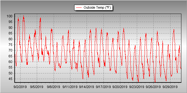
The result was clear and served to make September 2019 one of the warmest Septembers on record. In fact, it was Denver’s second warmest September on record. Thornton wasn’t as warm but here too, it was our second warmest September since Thornton Weather launched 13 years ago.
Overall, Thornton saw an average temperature for the month of 67.0 degrees. This was well above Denver’s long term average temperature for September of 63.4 degrees. Out at DIA where the Mile High City’s official measurements are taken, it was even warmer with an average of 69.3 degrees for the month.
Temperatures in Thornton ranged from a high of 101 degrees on the 1st and 2nd down to a low of 41.7 degrees on the morning of the 26th. Denver’s maximum temperature for the month of 100 degrees came on the 2nd and its coldest of 40 degrees on the 22nd.
Denver’s 100 degree reading on the 2nd was not only a record high for the date, but it also was the latest in the year a 100 degree reading has ever been recorded. The old record was August 16th in 2002. Record high temperatures of 98 degrees were also recorded on the 1st and 5th.
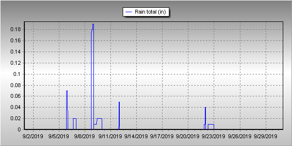
In terms of precipitation, Denver averages 0.96 inches during September. Thornton and Denver recorded identical totals in September 2019 of 0.41 inches, less than half of the average.
Thornton, Colorado’s September 2019 temperature summary. (ThorntonWeather.com)Thornton, Colorado’s September 2019 precipitation summary. (ThorntonWeather.com)
CLIMATE REPORT
NATIONAL WEATHER SERVICE DENVER/BOULDER CO
826 AM MDT TUE OCT 1 2019

...................................

...THE DENVER CO CLIMATE SUMMARY FOR THE MONTH OF SEPTEMBER 2019...

CLIMATE NORMAL PERIOD 1981 TO 2010
CLIMATE RECORD PERIOD 1872 TO 2019

WEATHER         OBSERVED          NORMAL  DEPART  LAST YEAR`S
                 VALUE   DATE(S)  VALUE   FROM    VALUE  DATE(S)
                                          NORMAL
................................................................
TEMPERATURE (F)
RECORD
 HIGH             100   09/02/2019
 LOW               17   09/29/1985

HIGHEST           100R  09/02        91       9       96  09/13
LOWEST             40   09/22        35       5       36  09/29
                                                          09/25
AVG. MAXIMUM     85.5              78.5     7.0     82.7
AVG. MINIMUM     53.2              48.3     4.9     52.8
MEAN             69.3              63.4     5.9     67.8
DAYS MAX >= 90      5               3.4     1.6        9
DAYS MAX <= 32      0               0.0     0.0        0
DAYS MIN <= 32      0               0.8    -0.8        0
DAYS MIN <= 0       0               0.0     0.0        0

PRECIPITATION (INCHES)
RECORD
 MAXIMUM         5.61   2013
 MINIMUM            T   1892
                        1944
TOTALS           0.41              0.96   -0.55     0.18
DAILY AVG.       0.01              0.03   -0.02     0.01
DAYS >= .01         3               6.5    -3.5        5
DAYS >= .10         2               3.3    -1.3        0
DAYS >= .50         0               0.6    -0.6        0
DAYS >= 1.00        0               0.1    -0.1        0
GREATEST
 24 HR. TOTAL    0.26   09/08 TO 09/08

SNOWFALL (INCHES)
RECORD SEPTEMBER 17.2   1971
 TOTAL            0.0               1.3

DEGREE_DAYS
HEATING TOTAL      22               125    -103       69
 SINCE 7/1         22               141    -119       78
COOLING TOTAL     158                76      82      160
 SINCE 1/1        915               764     151     1022

FREEZE DATES
RECORD
 EARLIEST     09/08/1962
 LATEST       06/08/2007
EARLIEST                        10/07
LATEST                          05/05
.................................................................

WIND (MPH)
AVERAGE WIND SPEED              10.3
RESULTANT WIND SPEED/DIRECTION   3/165
HIGHEST WIND SPEED/DIRECTION    43/260    DATE  09/08
HIGHEST GUST SPEED/DIRECTION    56/260    DATE  09/08

SKY COVER
POSSIBLE SUNSHINE (PERCENT)   MM
AVERAGE SKY COVER           0.40
NUMBER OF DAYS FAIR           14
NUMBER OF DAYS PC             15
NUMBER OF DAYS CLOUDY          1

AVERAGE RH (PERCENT)     45

-  INDICATES NEGATIVE NUMBERS.
R  INDICATES RECORD WAS SET OR TIED.
MM INDICATES DATA IS MISSING.
T  INDICATES TRACE AMOUNT.
With the first full month of fall here, October usually brings one of the quietest weather months in the Denver area with plenty of mild, sunny days and clear, cool nights.
October is historically the second sunniest month and conditions are generally calm.
However we also will usually see our first taste of winter during the month with the first freeze and first snowfall of the season.
Temperatures as well will start to drop and by the end of the month the average nighttime lows are below freezing.
Don’t miss a thing when it comes to our ever-changing weather! Be sure to ‘like’ us on Facebook, follow us on Twitter and add us to your Google+ circles.
Only five days into the month of September and the heat has records falling left and right.
Today, at 2:05pm, the temperature at Denver International Airport where Denver’s official readings are taken, reached 98 degrees. This topped the previous record high for September 5 of 97 degrees set in 2013 and 1899.
Here in Thornton we were actually warmer with a high of 99 degrees coming at 2:58pm.
Today’s record comes on the heels of record highs on the 1st and the 2nd of the month.
The 100 degree high of the 2nd was also the latest 100 degree reading ever recorded in Denver and also the warmest September temperature on record.
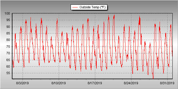
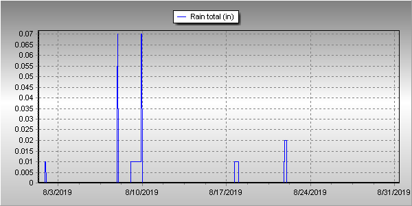
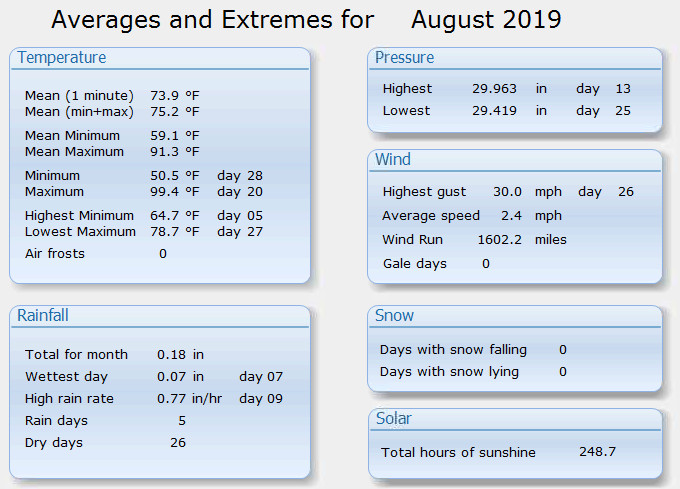
The month of August usually brings respectable amounts of precipitation and by the latter part of the month, cooler temperatures. Mother Nature however had other plans last month keeping the heat on and the moisture at bay.
A dry, westerly flow was dominant for much of the month. While there were a few cool fronts and PM thunderstorms, these failed to amount to much at all and were a rarity.
Thornton saw 21 days of 90 degree or higher readings during the month. Only five days saw precipitation and three of those were in virtually negligible amounts.
Thornton’s overall average temperature for the month was 73.9 degrees. This makes it the warmest August since ThorntonWeather.com came online 13 years ago. The reading was a good ways above the long-term Denver average for the month of 72.5 degrees.
At DIA, where Denver’s official temperatures are recorded, it was even warmer with an average of 75.4 degrees. This put August 2019 into the books tying August 2007 as the warmest August ever recorded in the Mile High City.
One temperature record was set in Denver during the month when on the 19th, the high temperature topped out at 99 degrees. This topped the old record high for the date of 97 degrees.
In terms of precipitation, Denver averages 1.69 inches during the month of August. This year, Thornton recorded a paltry 0.18 inch during the month. Denver fared a bit better with 0.58 inches. Both were clearly far short of average and Thornton’s was the least amount of precipitation received in August since ThorntonWeather.com came online 13 years ago.
Thornton, Colorado’s August 2019 temperature summary. (ThorntonWeather.com)Thornton, Colorado’s August 2019 precipitation summary. (ThorntonWeather.com)Thornton, Colorado’s August 2019 weather summary. (ThorntonWeather.com)
CLIMATE REPORT
NATIONAL WEATHER SERVICE DENVER/BOULDER CO
910 AM MDT SUN SEP 1 2019

...................................

...THE DENVER CO CLIMATE SUMMARY FOR THE MONTH OF AUGUST 2019...

CLIMATE NORMAL PERIOD 1981 TO 2010
CLIMATE RECORD PERIOD 1872 TO 2019

WEATHER         OBSERVED          NORMAL  DEPART  LAST YEAR`S
                 VALUE   DATE(S)  VALUE   FROM    VALUE  DATE(S)
                                          NORMAL
................................................................
TEMPERATURE (F)
RECORD
 HIGH             105   08/08/1878
 LOW               40   08/26/1910
                        08/25/1910
                        08/24/1910

HIGHEST            99   08/19
LOWEST             51   08/28

AVG. MAXIMUM     90.5              87.2     3.3     86.8
AVG. MINIMUM     60.2              57.9     2.3     58.0
MEAN             75.4              72.5     2.9     72.4
DAYS MAX >= 90     18              11.5     6.5       11
DAYS MAX <= 32      0               0.0     0.0        0
DAYS MIN <= 32      0               0.0     0.0        0
DAYS MIN <= 0 0 0.0 0.0 0
PRECIPITATION (INCHES)
 RECORD MAXIMUM 5.85 1979
 MINIMUM 0.02 1924
TOTALS 0.58 1.69 -1.11 0.93
DAILY AVG. 0.02 0.05 -0.03 0.03
DAYS >= .01         3               8.6    -5.6        7
DAYS >= .10         1               4.3    -3.3        2
DAYS >= .50         0               1.2    -1.2        0
DAYS >= 1.00        0               0.3    -0.3        0
GREATEST
 24 HR. TOTAL    0.46   08/08 TO 08/08           08/14 TO 08/14

SNOWFALL (INCHES)
TOTALS            0.0               0.0

DEGREE_DAYS
HEATING TOTAL       0                10     -10        9
 SINCE 7/1          0                16     -16        9
COOLING TOTAL     326               244      82      247
 SINCE 1/1        757               688      69      862

FREEZE DATES
RECORD
 EARLIEST     09/08/1962
 LATEST       06/08/2007
EARLIEST                        10/07
LATEST                          05/05
.................................................................

WIND (MPH)
AVERAGE WIND SPEED              9.3
RESULTANT WIND SPEED/DIRECTION   2/155
HIGHEST WIND SPEED/DIRECTION    40/020    DATE  08/20
HIGHEST GUST SPEED/DIRECTION    56/020    DATE  08/20

SKY COVER
POSSIBLE SUNSHINE (PERCENT)   MM
AVERAGE SKY COVER           0.50
NUMBER OF DAYS FAIR            9
NUMBER OF DAYS PC             21
NUMBER OF DAYS CLOUDY          1

AVERAGE RH (PERCENT)     50

-  INDICATES NEGATIVE NUMBERS.
R  INDICATES RECORD WAS SET OR TIED.
MM INDICATES DATA IS MISSING.
T  INDICATES TRACE AMOUNT.
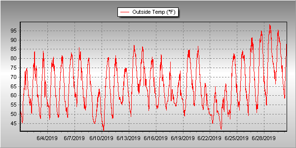
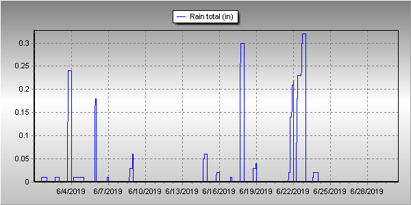
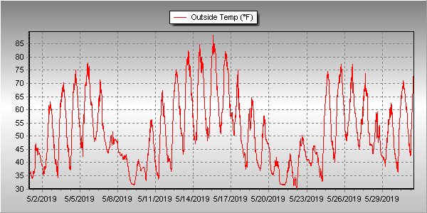
Unsettled would be a good word to sum up Thornton’s weather for June 2019. We experienced a series of troughs and fronts that kept things unsettled and suppressed temperatures. That however did not translate into a great deal of precipitation.
Cooler than normal temperatures were seen across much of the month. Even the later part of June saw some days with high temperatures only in the 60s.
It wasn’t even until the 26th of the month that Denver and Thornton recorded their first 90 degree day of the year. This was in fact the fifth latest occurrence of a 90 degree day in Denver and the latest since 1982.
Thornton’s average temperature for the month came in at 65.7 degrees. This made the month the second coolest June Thornton has recorded in 13 years. Denver saw a virtually identical average of 65.6 degrees. Both readings were below the long term Denver average for June of 67.4 degrees.
Temperatures in Thornton ranged from a high of 98.5 degrees of the 28th of the month down to a low of 40.7 degrees on the morning of the 10th. Denver’s highest reading of 96 degrees came on the 29th and its coolest of 42 degrees on the 10th.
Denver averages 1.98 inches of precipitation during the month of June. This year, Thornton fell short of the mark while Denver exceeded it. Here in Thornton we tallied 1.51 inches while Denver saw 2.24 inches.
Thornton, Colorado’s June 2019 temperature summary. (ThorntonWeather.com)Thornton, Colorado’s June 2019 precipitation summary. (ThorntonWeather.com)
CLIMATE REPORT
NATIONAL WEATHER SERVICE DENVER/BOULDER CO
1129 AM MDT MON JUL 1 2019

...................................

...THE DENVER CO CLIMATE SUMMARY FOR THE MONTH OF JUNE 2019...

CLIMATE NORMAL PERIOD 1981 TO 2010
CLIMATE RECORD PERIOD 1872 TO 2019

WEATHER         OBSERVED          NORMAL  DEPART  LAST YEAR`S
                 VALUE   DATE(S)  VALUE   FROM    VALUE  DATE(S)
                                          NORMAL
................................................................
TEMPERATURE (F)
RECORD
 HIGH             105   06/28/2018
                        06/26/2012
                        06/25/2012
 LOW               30   06/02/1951
HIGHEST            96   06/29       104      -8      105  06/28
                        06/28
LOWEST             42   06/10        30      12       44  06/02
                        06/09
AVG. MAXIMUM     80.1              82.4    -2.3     88.8
AVG. MINIMUM     51.2              52.3    -1.1     56.0
MEAN             65.6              67.4    -1.8     72.4
DAYS MAX >= 90      5               7.9    -2.9       16
DAYS MAX <= 32      0               0.0     0.0        0
DAYS MIN <= 32      0               0.0     0.0        0
DAYS MIN <= 0       0               0.0     0.0        0

PRECIPITATION (INCHES)
RECORD
 MAXIMUM         4.96   1882
 MINIMUM            T   1890
TOTALS           2.24              1.98    0.26     0.43
DAILY AVG.       0.07              0.07    0.00     0.01
DAYS >= .01        12               8.4     3.6        5
DAYS >= .10         6               4.6     1.4        2
DAYS >= .50         1               1.4    -0.4        0
DAYS >= 1.00        0               0.3    -0.3        0
GREATEST
 24 HR. TOTAL    0.97   06/18 TO 06/18

SNOWFALL (INCHES)
RECORDS
 TOTAL             MM   MM
TOTALS            0.0               0.0

DEGREE_DAYS
HEATING TOTAL      62                62       0        9
 SINCE 7/1       6281              6058     223     5410
COOLING TOTAL      87               133     -46      241
 SINCE 1/1         92               155     -63      289

FREEZE DATES
RECORD
 EARLIEST     09/08/1962
 LATEST       06/08/2007
EARLIEST      10/10             10/07
LATEST        05/22             05/05
.................................................................

WIND (MPH)
AVERAGE WIND SPEED              9.7
RESULTANT WIND SPEED/DIRECTION   3/182
HIGHEST WIND SPEED/DIRECTION    43/180    DATE  06/02
HIGHEST GUST SPEED/DIRECTION    56/200    DATE  06/02

SKY COVER
POSSIBLE SUNSHINE (PERCENT)   MM
AVERAGE SKY COVER           0.60
NUMBER OF DAYS FAIR            1
NUMBER OF DAYS PC             26
NUMBER OF DAYS CLOUDY          3

AVERAGE RH (PERCENT)     54

WEATHER CONDITIONS. NUMBER OF DAYS WITH
  0
  5
  0
  1
  0
  0
  1
HAZE                      2

-  INDICATES NEGATIVE NUMBERS.
R  INDICATES RECORD WAS SET OR TIED.
MM INDICATES DATA IS MISSING.
T  INDICATES TRACE AMOUNT.
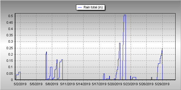
There is little doubt that looking back on the month the most notable feature was the cool, sometimes chilly, temperatures. Denver in fact saw one of its coldest on record. Precipitation for Thornton lagged but Denver itself was quite wet.
A seemingly endless series of storm systems impacted the state through the month. Overall, the first week was seasonal and dry. Temperatures then cooled for a couple of days and delivered us a light shot of snow. We rebounded with a series of 80 degree days from the 13th to the 16 before once again chilling out.
From the 18th to the 23rd, temperatures remained below normal and on the 21st we received a respectable 3.3 inches of snow. Temperatures during that period dropped to below freezing three times.
The balance of the month continued the roller coaster with a few mild days followed by cooler ones.
Thornton’s overall average monthly temperature for May came in at 51.9 degrees. This made it the coldest May since ThorntonWeather.com came online 13 years ago.
Out at DIA where Denver’s official measurements are taken, the month was comparable with a 51.6 degree average. That made May 2019 the seventh coldest May on record and the coldest since 1995.
Highs ranged in Thornton from a maximum of 89 degrees on the 15th down to a lowest reading of 29.8 degrees on the 22nd. Denver’s highest reading of 83 degrees and its coldest of 30 degrees came on the same dates.
Three temperature records were officially set in Denver. The record low for May 21st of 31 degrees was tied. Also on that day, a record low maximum of 39 degrees was set. The old record was 40 degrees set in 1891. Lastly, the low on the 22nd of 30 degrees broke the record low reading for the date of 32 degrees set in 1930.
In terms of precipitation, Denver averages 2.12 inches during the month. Thornton came close to matching that with 2.03 inches. Out at the airport, it was wetter with 3.23 inches being recorded.
Thornton saw a total of 4.1 inches of snow for the month while Denver saw a bit less at 3.9 inches. Both were well above the May average of 1.1 inches.
May 2019 temperature summary for Thornton, Colorado.May 2019 precipitation summary for Thornton, Colorado.
CLIMATE REPORT
NATIONAL WEATHER SERVICE DENVER/BOULDER CO
753 AM MDT SAT JUN 1 2019

...................................

...THE DENVER CO CLIMATE SUMMARY FOR THE MONTH OF MAY 2019...

CLIMATE NORMAL PERIOD 1981 TO 2010
CLIMATE RECORD PERIOD 1872 TO 2019

WEATHER         OBSERVED          NORMAL  DEPART  LAST YEAR`S
                 VALUE   DATE(S)  VALUE   FROM    VALUE  DATE(S)
                                          NORMAL
................................................................
TEMPERATURE (F)
RECORD
 HIGH              95   05/26/1942
 LOW               19   05/02/2013
                        05/03/1907
HIGHEST            83   05/15
LOWEST             30   05/22
                        05/01

AVG. MAXIMUM     63.9              71.5    -7.6     75.4
AVG. MINIMUM     39.2              42.7    -3.5     47.5
MEAN             51.6              57.1    -5.5     61.4
DAYS MAX >= 90      0               0.8    -0.8        4
DAYS MAX <= 32      0               0.0     0.0        0
DAYS MIN <= 32      7               1.9     5.1        0
DAYS MIN <= 0 0 0.0 0.0 0 PRECIPITATION (INCHES) RECORD MAXIMUM 8.57 1876 MINIMUM 0.06 1974 TOTALS 3.23 2.12 1.11 1.86 DAILY AVG. 0.10 0.07 0.03 0.06 DAYS >= .01        14               9.4     4.6        8
DAYS >= .10         7               4.8     2.2        5
DAYS >= .50         3               1.2     1.8        0
DAYS >= 1.00        1               0.2     0.8        0
GREATEST
 24 HR. TOTAL    1.07   05/20 TO 05/20

SNOWFALL (INCHES)
TOTALS            3.9   2019        1.1 (NCEI 1981-2018 AVG)
RECORD           15.5   1898

DEGREE_DAYS
HEATING TOTAL     414               265     149      151
 SINCE 7/1       6219              5996     223     5401
COOLING TOTAL       5                21     -16       46
 SINCE 1/1          5                22     -17       48

FREEZE DATES
RECORD
 EARLIEST     09/08/1962
 LATEST       06/08/2007
EARLIEST                        10/07
LATEST                          05/05
.................................................................

WIND (MPH)
AVERAGE WIND SPEED              10.0
RESULTANT WIND SPEED/DIRECTION   1/090
HIGHEST WIND SPEED/DIRECTION    35/310    DATE  05/17
HIGHEST GUST SPEED/DIRECTION    50/310    DATE  05/17

SKY COVER
POSSIBLE SUNSHINE (PERCENT)   MM
AVERAGE SKY COVER           0.60
NUMBER OF DAYS FAIR            3
NUMBER OF DAYS PC             16
NUMBER OF DAYS CLOUDY         12

AVERAGE RH (PERCENT)     64

-  INDICATES NEGATIVE NUMBERS.
R  INDICATES RECORD WAS SET OR TIED.
MM INDICATES DATA IS MISSING.
T  INDICATES TRACE AMOUNT.
Weather, natural disasters & climate news and information.


 The weather during the month of November in Denver metro area can offer just about anything. While it is normally a quiet month, it can be prone to extremes.
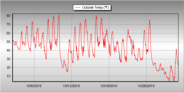
 With the first full month of fall here, October usually brings one of the quietest weather months in the Denver area with plenty of mild, sunny days and clear, cool nights.