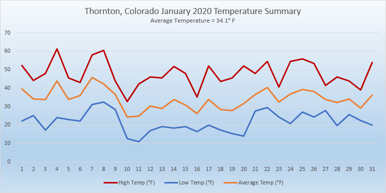
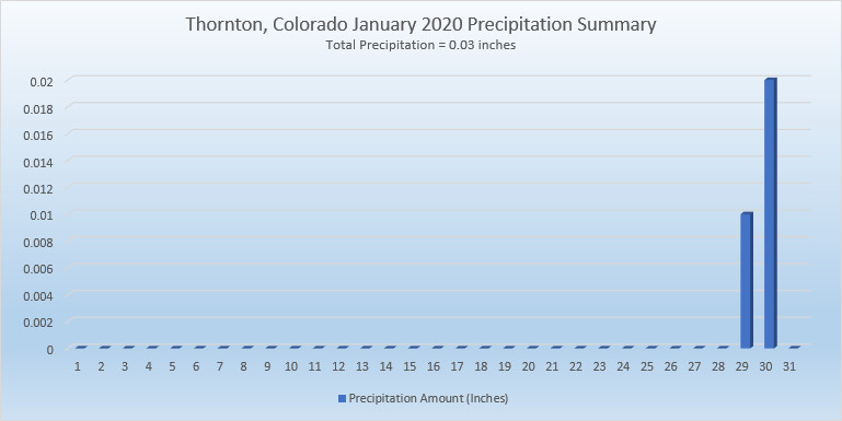
As we begin the new year the winter chill begins to set in. While January can see its share of extremes, the month historically sees stable temperatures and is usually relatively dry.
January ranks as the second coldest month in Denver next to December with average temperatures remaining virtually the same from the start to the end of the month.
In terms of snowfall, the month only ranks as the fourth snowiest and it is not uncommon for it to be quite dry.
What does January 2020 hold for us? Follow the link to find out.
Winter officially begins at 9:28am MST on Thursday, December 21, 2017. (NOAA)
Astronomical winter arrives in Thornton Saturday evening and with the solstice also comes the shortest day of the year.
Winter officially begins at 9:19pm MST on Saturday, December 21, 2019.
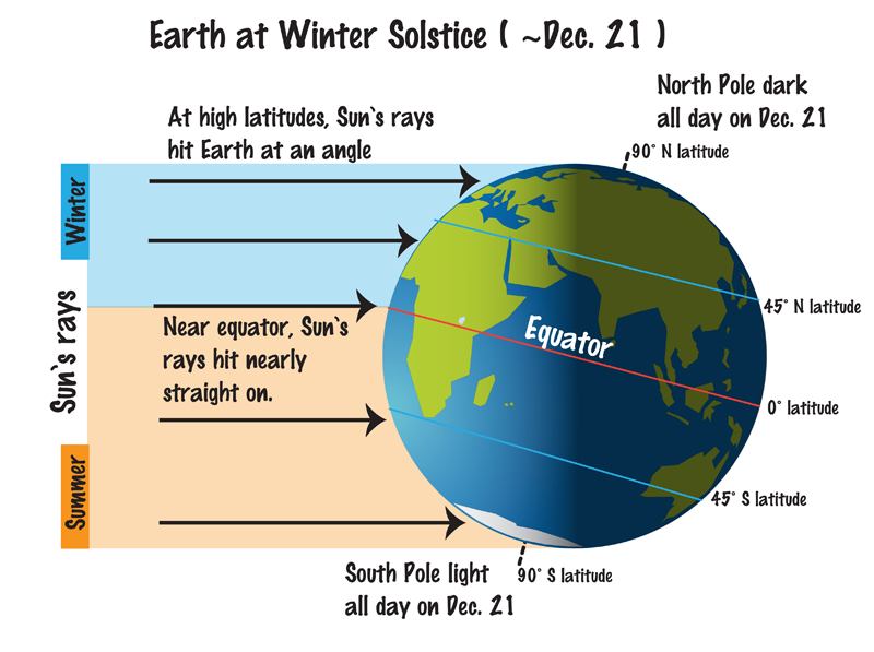
The Winter Solstice occurs when the North Pole is tilted at its furthest from the sun – 23.5 degrees away. This results in the shortest day of the year in the Northern Hemisphere.
Here in Denver, with sunrise at 7:17am and sunset at 4:38pm, our day Saturday will be 9 hours, 21 minutes and 16 seconds long.
The following day, Sunday, it will be about a second longer and each day from now through to the Summer Solstice in June will get gradually longer as well.
While we have a short day on the solstice, it is nothing like what will be experienced in the Arctic Circle. Areas north of there to the North Pole will have no direct sunlight at all. Conversely, areas south of the Antarctic Circle toward the South Pole will have 24 hours of daylight and have a midnight sun.
Did you know that there is a difference between the astronomical seasons that we are discussing here and meteorological seasons?
Meteorological seasons differ slightly and are geared toward matching the calendar with the annual temperature cycle. This is done primarily for meteorological observing and forecasting and in many ways it is more logical than the astronomical seasons.
For the Northern Hemisphere, the meteorological spring covers the months of March, April and May. Summer brings the hottest months of the year and so meteorological summer is June, July and August. Meteorological fall then is September, October and November followed by the coldest months of December, January and February as meteorological winter.
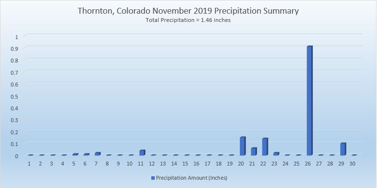
For the second month in a row, Mother Nature kept us cold and delivered a healthy dose of snow. Thornton experienced its second coldest November of the past 13 years and the snowiest of the past 13 years.
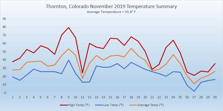
The month started out chilly but soon saw things stabilize and turn seasonal. Then, the 8th and 9th offered up our two warmest days of the month with readings of 71 and 79 degrees respectively. We quickly chilled out and saw our first snowfall of the month on the 9th although it was minimal.
From the 12th to the 19th, weather was relatively calm and temperatures for the most part warmer than normal.
After that, things went downhill with most of the balance of the month seeing temperatures well below normal. Light snow on the 20th, 21st and 22nd was followed by our most significant storm of the season on the 26th.
Thornton saw an overall overage temperature for November of 35.6 degrees. This was a good ways below the long term Denver average for the month of 38.3 degrees. Out at Denver International Airport where Denver’s official measurements are taken, the average temperature for the month was 36.2 degrees.
Temperatures in Thornton ranged from a high of 79 degrees on the 9th down to a low of 2 degrees on the 27th. Out at the airport, Denver saw its warmest reading of 77 degrees on the 9th also and its coldest temperature of -2 degrees on the 27th. The high temperature on the 9th was a record high for the date.
A generous amount of precipitation was received with Thornton recording 1.46 inches of rain and snowmelt. Denver lagged a bit with 1.31 inches. Both readings were well above the long term Denver average of 0.61 inches for November.
In terms of snowfall, the Mile High City averages 8.7 inches in November. Thornton’s reading of 16.7 inches and Denver’s of 13.7 inches easily bested the average.
CLIMATE REPORT
NATIONAL WEATHER SERVICE DENVER/BOULDER CO
905 AM MST SUN DEC 1 2019
...................................
...THE DENVER CO CLIMATE SUMMARY FOR THE MONTH OF NOVEMBER 2019...
CLIMATE NORMAL PERIOD 1981 TO 2010
CLIMATE RECORD PERIOD 1872 TO 2019
WEATHER OBSERVED NORMAL DEPART LAST YEAR`S
VALUE DATE(S) VALUE FROM VALUE DATE(S)
NORMAL
................................................................
TEMPERATURE (F)
RECORD
HIGH 81 11/27/2017
LOW -18 11/29/1877
HIGHEST 77 11/09 73 4 65 11/02
LOWEST -2 11/27 -6 4 10 11/12
AVG. MAXIMUM 49.7 52.1 -2.4 50.6
AVG. MINIMUM 22.7 24.5 -1.8 25.0
MEAN 36.2 38.3 -2.1 37.8
DAYS MAX >= 90 0 0.0 0.0 0
DAYS MAX <= 32 7 2.3 4.7 2
DAYS MIN <= 32 25 23.4 1.6 27
DAYS MIN <= 0 1 0.6 0.4 0
PRECIPITATION (INCHES)
RECORD
MAXIMUM 3.21 1946
MINIMUM T 1899
1901
1949
TOTALS 1.31 0.61 0.70 0.35
DAILY AVG. 0.04 0.02 0.02 0.01
DAYS >= .01 8 4.7 3.3 6
DAYS >= .10 4 1.6 2.4 1
DAYS >= .50 1 0.0 1.0 0
DAYS >= 1.00 0 0.0 0.0 0
GREATEST
24 HR. TOTAL 0.80 11/26 TO 11/26 11/11 TO 11/11
SNOWFALL (INCHES)
RECORDS
TOTAL 13.7 8.7
RECORD NOVEMBER 42.5 1946
DEGREE_DAYS
HEATING TOTAL 860 801 59 808
SINCE 7/1 1535 1382 153 1373
COOLING TOTAL 0 0 0 0
SINCE 1/1 916 769 147 1026
FREEZE DATES
RECORD
EARLIEST 09/08/1962
LATEST 06/08/2007
EARLIEST 10/07
LATEST 05/05
.................................................................
WIND (MPH)
AVERAGE WIND SPEED 9.3
RESULTANT WIND SPEED/DIRECTION 2/197
HIGHEST WIND SPEED/DIRECTION 37/020 DATE 11/16
HIGHEST GUST SPEED/DIRECTION 48/010 DATE 11/16
SKY COVER
POSSIBLE SUNSHINE (PERCENT) MM
AVERAGE SKY COVER 0.50
NUMBER OF DAYS FAIR 7
NUMBER OF DAYS PC 18
NUMBER OF DAYS CLOUDY 5
AVERAGE RH (PERCENT) 65
- INDICATES NEGATIVE NUMBERS.
R INDICATES RECORD WAS SET OR TIED.
MM INDICATES DATA IS MISSING.
T INDICATES TRACE AMOUNT.
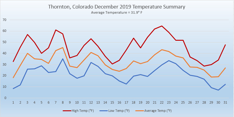
October and November brought Thornton cooler than normal temperatures and a good bit more snow than usual. What will December hold for us?
The month of December brings with it the official start of winter and oftentimes, colder and snowier weather conditions.
It however can also offer unseasonably warm temperatures and bone dry conditions. Given our recent mild and dry weather, we are certainly hoping for a change in the coming month.
Overall December’s monthly mean temperature of 30.0 degrees (1981 – 2010 averages) makes it our coldest month. Snow is always on everyone’s mind this time of year but December is only our 3rd snowiest month behind March and November with an average of 8.5 inches of the white stuff.
We knew today would be the warmest day of the weekend and not only did that hold true, it was a record setting performance.
As measured at DIA, Denver’s high temperature today reached 77 degrees (as of this writing). That bested the record high temperature for November 9th of 76 degrees set in 1927.
Here in Thornton, we were a bit warmer with a high of 79 degrees.
The weather during the month of November in Denver metro area can offer just about anything. While it is normally a quiet month, it can be prone to extremes.
November has historically been one of Denver’s snowiest months and major snowstorms are not entirely uncommon. However conditions can also be quite dry.
Temperatures during the month continue to cool as we get closer to winter and by the end of the month the low temperatures routinely dip to 20 degrees or below. At times it can in fact bring conditions more like what we see in January.
There is little doubt that when folks’ memories go back October 2019’s weather, they will remember the snow and even more so, the cold. Numerous cold temperature records were broken and the month ended up as one of the coldest Octobers on record.
Things started off cool for the first few days and a bit of precipitation. We then warmed up and dried out, seeing our warmest temperatures of the month on the 7th, 8th and 9th. From there, it was mostly downhill.
The evening of the 9th saw a powerful storm system and cold front move across northeastern Colorado. Temperatures plummeted and we saw our first snowfall of the season. Denver officially saw a 70 degree temperature change from the 9th to the 10th, tying the period for the second largest two-day temperature swing in Denver history.
High pressure returned on the 12th and we warmed up and dried out again. Cool but non-dramatic conditions arrived for the 18th through the 23rd. We then saw our second snowfall on the 24th of the month.
A brief rebound saw us warm up and enjoy a day of warmer than normal temperatures on the 26th. Once again, Mother Nature dropped the hammer with cold and snow returning on the 27th. The final five days of the month saw us receive two shots of snow and temperatures more akin to what we would expect to see in January.
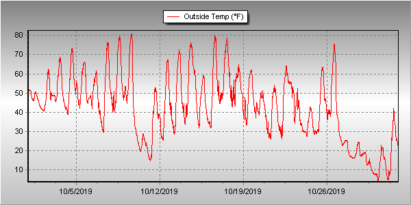
Overall, Thornton’s average temperature for the month was 42.8 degrees. This was far below the long term Denver average for October of 50.9 degrees and was Thornton’s second coldest October since ThorntonWeather.com came online in the fall of 2006.
Out at Denver International Airport where the Mile High City’s official measurements are taken, it was slightly warmer with an average of 43.7 degrees. That made the month the fourth coldest October in Denver weather history.
Denver saw six cold weather daily temperature records fall. Among them were a record low of 13 degrees on the 10th, a record low on the 11th, record low maximums on the 28th and the 29th, and then two more record low temperatures on the 30th and 31st.
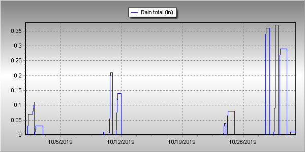
In terms of precipitation, Denver averages 1.02 inches of liquid during the month of October. Thornton bested that handily with 1.54 inches in our rain bucket. At DIA, it was drier with only 0.91 inches officially.
Snow was abundant in Thornton and Denver. Thornton received 17.6 inches of the white stuff while Denver came in at 12.5 inches. The Denver measurement made the month the 12th snowiest in Denver weather history.
Thornton, Colorado’s October 2019 Temperature Summary.Thornton, Colorado’s October 2019 Precipitation Summary.
CLIMATE REPORT
NATIONAL WEATHER SERVICE DENVER/BOULDER CO
230 PM MDT FRI NOV 1 2019
...................................
...THE DENVER CO CLIMATE SUMMARY FOR THE MONTH OF OCTOBER 2019...
CLIMATE NORMAL PERIOD 1981 TO 2010
CLIMATE RECORD PERIOD 1872 TO 2019
WEATHER OBSERVED NORMAL DEPART LAST YEAR`S
VALUE DATE(S) VALUE FROM VALUE DATE(S)
NORMAL
................................................................
TEMPERATURE (F)
RECORD
HIGH 90 10/01/1892
LOW -2 10/29/1917
HIGHEST 83 10/09 83 0 86 10/03
LOWEST 3 10/30 22 -19 18 10/15
AVG. MAXIMUM 58.5 65.3 -6.8 61.5
AVG. MINIMUM 28.9 36.6 -7.7 36.8
MEAN 43.7 50.9 -7.2 49.2
DAYS MAX >= 90 0 0.0 0.0 0
DAYS MAX <= 32 5 0.4 4.6 1
DAYS MIN <= 32 18 8.5 9.5 7
DAYS MIN <= 0 0 0.0 0.0 0
PRECIPITATION (INCHES)
RECORD
MAXIMUM 4.17 1969
MINIMUM T 1934
TOTALS 0.91 1.02 -0.11 0.99
DAILY AVG. 0.03 0.03 0.00 0.03
DAYS >= .01 9 5.3 3.7 9
DAYS >= .10 4 2.4 1.6 3
DAYS >= .50 0 0.5 -0.5 0
DAYS >= 1.00 0 0.1 -0.1 0
GREATEST
24 HR. TOTAL 0.22 10/29 TO 10/29
SNOWFALL (INCHES)
RECORDS
TOTAL 12.5 4.0
RECORD OCTOBER 31.2 1969
DEGREE_DAYS
HEATING TOTAL 653 440 213 487
SINCE 7/1 675 581 94 565
COOLING TOTAL 1 5 -4 4
SINCE 1/1 916 769 147 1026
FREEZE DATES
RECORD
EARLIEST 09/08/1962
LATEST 06/08/2007
EARLIEST 10/09 10/07
LATEST 05/05
.................................................................
WIND (MPH)
AVERAGE WIND SPEED 10.0
RESULTANT WIND SPEED/DIRECTION 1/209
HIGHEST WIND SPEED/DIRECTION 46/040 DATE 10/09
HIGHEST GUST SPEED/DIRECTION 57/030 DATE 10/09
SKY COVER
POSSIBLE SUNSHINE (PERCENT) MM
AVERAGE SKY COVER 0.40
NUMBER OF DAYS FAIR 13
NUMBER OF DAYS PC 13
NUMBER OF DAYS CLOUDY 5
AVERAGE RH (PERCENT) 51
- INDICATES NEGATIVE NUMBERS.
R INDICATES RECORD WAS SET OR TIED.
MM INDICATES DATA IS MISSING.
T INDICATES TRACE AMOUNT.
For the second month in a row, Thornton saw temperatures well above normal and precipitation well below average. While the first half of 2019 started out cool and wet, the second appears to be headed the opposite direction.
High pressure was the dominating feature for the month. This served to keep precipitation away and colder air to our north.
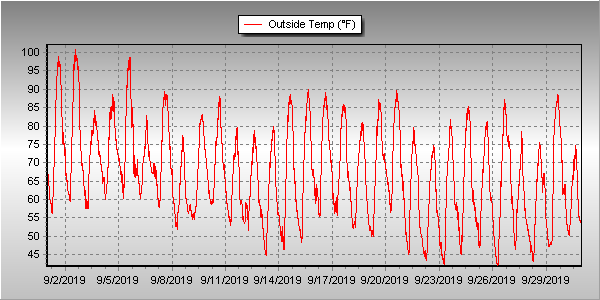
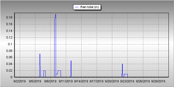
The result was clear and served to make September 2019 one of the warmest Septembers on record. In fact, it was Denver’s second warmest September on record. Thornton wasn’t as warm but here too, it was our second warmest September since Thornton Weather launched 13 years ago.
Overall, Thornton saw an average temperature for the month of 67.0 degrees. This was well above Denver’s long term average temperature for September of 63.4 degrees. Out at DIA where the Mile High City’s official measurements are taken, it was even warmer with an average of 69.3 degrees for the month.
Temperatures in Thornton ranged from a high of 101 degrees on the 1st and 2nd down to a low of 41.7 degrees on the morning of the 26th. Denver’s maximum temperature for the month of 100 degrees came on the 2nd and its coldest of 40 degrees on the 22nd.
Denver’s 100 degree reading on the 2nd was not only a record high for the date, but it also was the latest in the year a 100 degree reading has ever been recorded. The old record was August 16th in 2002. Record high temperatures of 98 degrees were also recorded on the 1st and 5th.
In terms of precipitation, Denver averages 0.96 inches during September. Thornton and Denver recorded identical totals in September 2019 of 0.41 inches, less than half of the average.
Thornton, Colorado’s September 2019 temperature summary. (ThorntonWeather.com)Thornton, Colorado’s September 2019 precipitation summary. (ThorntonWeather.com)
CLIMATE REPORT
NATIONAL WEATHER SERVICE DENVER/BOULDER CO
826 AM MDT TUE OCT 1 2019
...................................
...THE DENVER CO CLIMATE SUMMARY FOR THE MONTH OF SEPTEMBER 2019...
CLIMATE NORMAL PERIOD 1981 TO 2010
CLIMATE RECORD PERIOD 1872 TO 2019
WEATHER OBSERVED NORMAL DEPART LAST YEAR`S
VALUE DATE(S) VALUE FROM VALUE DATE(S)
NORMAL
................................................................
TEMPERATURE (F)
RECORD
HIGH 100 09/02/2019
LOW 17 09/29/1985
HIGHEST 100R 09/02 91 9 96 09/13
LOWEST 40 09/22 35 5 36 09/29
09/25
AVG. MAXIMUM 85.5 78.5 7.0 82.7
AVG. MINIMUM 53.2 48.3 4.9 52.8
MEAN 69.3 63.4 5.9 67.8
DAYS MAX >= 90 5 3.4 1.6 9
DAYS MAX <= 32 0 0.0 0.0 0
DAYS MIN <= 32 0 0.8 -0.8 0
DAYS MIN <= 0 0 0.0 0.0 0
PRECIPITATION (INCHES)
RECORD
MAXIMUM 5.61 2013
MINIMUM T 1892
1944
TOTALS 0.41 0.96 -0.55 0.18
DAILY AVG. 0.01 0.03 -0.02 0.01
DAYS >= .01 3 6.5 -3.5 5
DAYS >= .10 2 3.3 -1.3 0
DAYS >= .50 0 0.6 -0.6 0
DAYS >= 1.00 0 0.1 -0.1 0
GREATEST
24 HR. TOTAL 0.26 09/08 TO 09/08
SNOWFALL (INCHES)
RECORD SEPTEMBER 17.2 1971
TOTAL 0.0 1.3
DEGREE_DAYS
HEATING TOTAL 22 125 -103 69
SINCE 7/1 22 141 -119 78
COOLING TOTAL 158 76 82 160
SINCE 1/1 915 764 151 1022
FREEZE DATES
RECORD
EARLIEST 09/08/1962
LATEST 06/08/2007
EARLIEST 10/07
LATEST 05/05
.................................................................
WIND (MPH)
AVERAGE WIND SPEED 10.3
RESULTANT WIND SPEED/DIRECTION 3/165
HIGHEST WIND SPEED/DIRECTION 43/260 DATE 09/08
HIGHEST GUST SPEED/DIRECTION 56/260 DATE 09/08
SKY COVER
POSSIBLE SUNSHINE (PERCENT) MM
AVERAGE SKY COVER 0.40
NUMBER OF DAYS FAIR 14
NUMBER OF DAYS PC 15
NUMBER OF DAYS CLOUDY 1
AVERAGE RH (PERCENT) 45
- INDICATES NEGATIVE NUMBERS.
R INDICATES RECORD WAS SET OR TIED.
MM INDICATES DATA IS MISSING.
T INDICATES TRACE AMOUNT.

With the first full month of fall here, October usually brings one of the quietest weather months in the Denver area with plenty of mild, sunny days and clear, cool nights.
October is historically the second sunniest month and conditions are generally calm.
However we also will usually see our first taste of winter during the month with the first freeze and first snowfall of the season.
Temperatures as well will start to drop and by the end of the month the average nighttime lows are below freezing.
Don’t miss a thing when it comes to our ever-changing weather! Be sure to ‘like’ us on Facebook, follow us on Twitter and add us to your Google+ circles.
Only five days into the month of September and the heat has records falling left and right.
Today, at 2:05pm, the temperature at Denver International Airport where Denver’s official readings are taken, reached 98 degrees. This topped the previous record high for September 5 of 97 degrees set in 2013 and 1899.
Here in Thornton we were actually warmer with a high of 99 degrees coming at 2:58pm.
Today’s record comes on the heels of record highs on the 1st and the 2nd of the month.
The 100 degree high of the 2nd was also the latest 100 degree reading ever recorded in Denver and also the warmest September temperature on record.
Weather, natural disasters & climate news and information.