
Wind and big time snowstorms can visit the Mile High City this time of year and we see many such events in our look back at this week in Denver weather history. Probably most notable, the Blizzard of 1913, the Mile High City’s biggest snowstorm in history.
- Stay up to date with Thornton’s weather: ‘Like’ us on Facebook, follow us on Twitter and add us to your Google+ circles
From the National Weather Service:
1-5
In 1913…the 1st marked the start of the heaviest 5-day total snowfall in the city’s history. During this period snowfall totaled 45.7 inches. Starting on the 1st…snow fell intermittently for 3 days and accumulated a little over 8 inches. On the 4th and 5th…an additional 37.4 inches of snow fell. At Georgetown in the foothills west of Denver even more snow fell…86 inches over the 5 days with the most…63 inches…on the 4th. In Colorado…snowfall was heavy along the eastern slopes of the mountains from the Palmer Divide north. High winds during the storm caused heavy drifting…which blocked all transportation. Snow cover of an inch or more from the storm persisted for 60 consecutive days from the 1st through January 29…1914. Additional snowfall in December and January prolonged the number of days. This is the third longest period of snow cover on record in the city.
2-3
In 1955…snowfall totaled only 2.9 inches at Stapleton Airport. This was the only measurable snowfall of the month.
In 1973…post-frontal heavy snowfall totaled 7.6 inches at Stapleton International Airport where northeast winds gusting to 37 mph caused some blowing snow.
In 1990…strong downslope winds raked the eastern foothills and most of metro Denver. A wind gust to 87 mph was recorded at Rollinsville with wind gusts to 58 mph in Arvada and 55 mph in Lakewood. West winds gusted to 48 mph at Stapleton International Airport on the 2nd.
In 1997…heavy snow fell in the foothills. Conifer received 10 inches of new snow. Snowfall totaled only 2.4 inches at the site of the former Stapleton International Airport on the 1st…2nd…and 3rd. North winds gusted to 24 mph at Denver International Airport on the 2nd.
2-4
In 1909…post-frontal snowfall totaled 6.1 inches in downtown Denver. Most of the snow…5.9 inches…fell between 6:00 pm on the 2nd and 6:00 pm on the 3rd. North winds were sustained to 18 mph on both the 2nd and 3rd.
2-17
In 1939…more than 2 weeks of unseasonably warm weather made the month the 3rd warmest on record. Seven daily temperature records were set…including the all time record high temperature for the month of 79 degrees on the 5th. Daytime highs were balmy with 14 days in the 60’s and 70’s. Low temperatures dipped to freezing or below on only 5 days. The period was dry with only a trace of snow on the 12th.
3
In 1977…high winds continued in Boulder and were clocked from 74 to 90 mph…causing only minor damage. Northwest winds gusted to 33 mph at Stapleton International Airport where the strong Chinook winds warmed the temperature to a high of 63 degrees.
In 1985…wind gusts to 78 mph were clocked at Table Mesa in Boulder. Winds gusted to 70 mph at Echo Lake west of Denver.
In 2011…Another round of snow developed in and near the Front Range Foothills. The heaviest snowfall occurred in the foothills of Boulder and northern Jefferson Counties. Storm totals included: 13 inches…7 miles southwest of Boulder; 10.5 inches…4 miles east-northeast of Nederland; 10 inches at Genesee; 9.5 inches…4 miles west-northwest of Boulder; 9 inches at Gross Reservoir and 4 miles east of Pinecliffe. Around the Urban Corridor…storm totals ranged from 3 to 8 inches…heaviest in and around Boulder.
3-4
In 1968…strong Chinook winds in Boulder gusting to 52 mph downtown caused 7 thousand dollars in damage. Flying debris damaged cars…houses…and other property in Boulder. West winds gusted to 49 mph late on the 3rd and to 45 mph on the 4th at Stapleton International Airport where the temperature climbed to a high of 60 degrees on the 4th.
In 1970…strong winds whistled through Boulder. Sustained winds of 40 mph with gusts to 70 mph were recorded at the National Bureau of Standards in Boulder. Wind gusts to 50 mph occurred in downtown Denver. No damage was reported. On the 3rd…northwest winds gusted to 40 mph at Stapleton International Airport where the Chinook winds warmed the temperature to a high of 66 degrees on the 4th.
In 1999…heavy snow fell over the foothills and metro Denver. The heaviest snowfall occurred in the foothills south of I-70 and near the Palmer Divide. Snowfall totals included: 25 inches near Tiny Town; 18 inches at Conifer; 15 inches near Evergreen; 14 inches at Chief Hosa…8 miles west of Castle Rock…and near Blackhawk; 12 inches at Pine Junction and 8 miles south of Sedalia; 11 inches atop Floyd Hill and in Roxborough; and 10 inches at Castle Rock. Around metro Denver…snowfall totals included: 10 inches at Highlands Ranch…9 inches at Parker…and 8 inches in Aurora and Wheat Ridge. Elsewhere around the metro area…snowfall generally ranged from 3 to 5 inches. Only 3.2 inches of snow fell at the site of the former Stapleton International Airport. North winds gusted to 32 mph at Denver International Airport on the 3rd.
In 2007…high winds developed in and near the Front Range foothills. Peak wind reports included: 88 mph atop Niwot Ridge; 87 mph atop mines peak; 80 mph…3 miles southeast of Jamestown; 78 mph at Longmont; 74 mph at Table Mesa. A few power outages occurred in Longmont as broken branches downed power lines. Northwest winds gusted to 38 mph at Denver International Airport on the 4th.
In 2013…a storm system brought heavy snow to parts of the Front Range Foothills. Storm totals included: 12 inches…7 miles west-southwest of Evergreen; 10.5 inches…3 miles north of Bailey; 9.5 inches…3 miles west of Jamestown and 5 miles northeast of Ward; 9 inches in Bailey…8.5 inches… 3 miles north of Conifer.
3-15
In 1972…a protracted cold spell held an icy grip on metro Denver when maximum temperatures never reached above freezing for 10 consecutive days from the 3rd through the 12th and minimum temperatures dipped below zero on eleven consecutive days from the 5th through the 15th. Daily low temperature records were set with 15 degrees below zero on the 5th…17 degrees below zero on the 6th… And 18 degrees below zero on the 10th. Daily record low maximum readings were set with 3 degrees on the 6th and 6 degrees on the 9th. The very cold temperatures were caused by 3 to 5 inches of snow cover and a Canadian air mass.
Continue reading December 3 to December 9: This week in Denver weather history
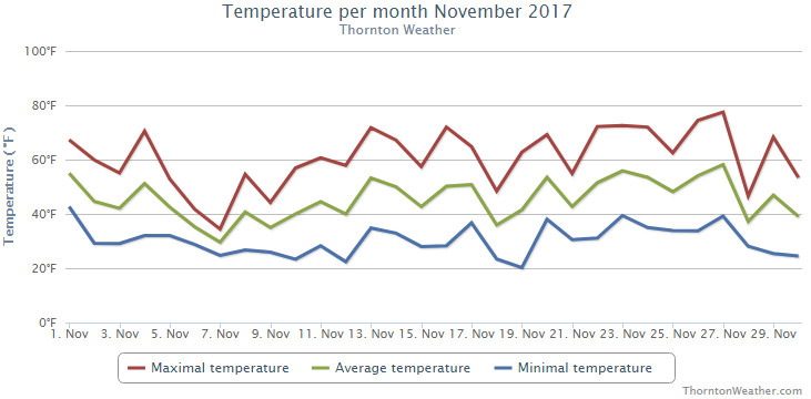
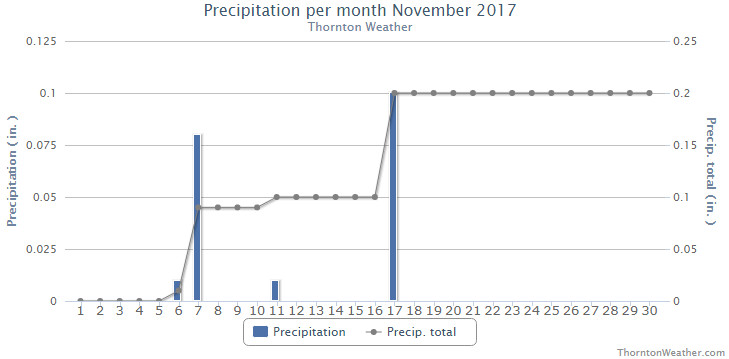
 November proved to be an extraordinarily warm and dry month. Does December have hope for relief?


