|
All posts by Thornton Weather
Paleontologists: Thornton’s dinosaur is in fact a torosaurus, not a triceratops
![The dinosaur fossil recently found in Thornton is in fact this creature - a torosaurus, not a triceratops as originally thought. (By Nobu Tamura (http://spinops.blogspot.com) (Own work) CC BY 3.0 (http://creativecommons.org/licenses/by/3.0)], via Wikimedia Commons)](https://upload.wikimedia.org/wikipedia/commons/9/95/Torosaurus_BW.jpg)
Thornton’s now famous dinosaur bones that were discovered at a construction site have been identified as a different prehistoric creature than originally thought.
Scientists with the Denver Museum of Nature and Science told CBS4 that they are actually remnants of a torosaurus, not a triceratops.
Dr. Joe Sertich, Curator of Dinosaurs at the museum, told the news station that the key in figuring out what it was came in the frill.
Sertich said, “I came in here and the preparators had cleaned off this part of the shield, the frill behind the head and I don’t think the preparators realized what this part was. This was a complete window opening in the frill.”
Sertich noted that the fact it is a torosaurus is in some ways even more exciting due to the rarity of that creature. This is in fact the only example of the torosaurus found in North America.
“This adds a really important single individual to a really rare dinosaur,” Sertich explained. “This is probably the most complete skull of a torosaurus.”
Watch the video of the report below.
December 3 to December 9: This week in Denver weather history

Wind and big time snowstorms can visit the Mile High City this time of year and we see many such events in our look back at this week in Denver weather history. Probably most notable, the Blizzard of 1913, the Mile High City’s biggest snowstorm in history.
- Stay up to date with Thornton’s weather: ‘Like’ us on Facebook, follow us on Twitter and add us to your Google+ circles
From the National Weather Service:
1-5
In 1913…the 1st marked the start of the heaviest 5-day total snowfall in the city’s history. During this period snowfall totaled 45.7 inches. Starting on the 1st…snow fell intermittently for 3 days and accumulated a little over 8 inches. On the 4th and 5th…an additional 37.4 inches of snow fell. At Georgetown in the foothills west of Denver even more snow fell…86 inches over the 5 days with the most…63 inches…on the 4th. In Colorado…snowfall was heavy along the eastern slopes of the mountains from the Palmer Divide north. High winds during the storm caused heavy drifting…which blocked all transportation. Snow cover of an inch or more from the storm persisted for 60 consecutive days from the 1st through January 29…1914. Additional snowfall in December and January prolonged the number of days. This is the third longest period of snow cover on record in the city.
2-3
In 1955…snowfall totaled only 2.9 inches at Stapleton Airport. This was the only measurable snowfall of the month.
In 1973…post-frontal heavy snowfall totaled 7.6 inches at Stapleton International Airport where northeast winds gusting to 37 mph caused some blowing snow.
In 1990…strong downslope winds raked the eastern foothills and most of metro Denver. A wind gust to 87 mph was recorded at Rollinsville with wind gusts to 58 mph in Arvada and 55 mph in Lakewood. West winds gusted to 48 mph at Stapleton International Airport on the 2nd.
In 1997…heavy snow fell in the foothills. Conifer received 10 inches of new snow. Snowfall totaled only 2.4 inches at the site of the former Stapleton International Airport on the 1st…2nd…and 3rd. North winds gusted to 24 mph at Denver International Airport on the 2nd.
2-4
In 1909…post-frontal snowfall totaled 6.1 inches in downtown Denver. Most of the snow…5.9 inches…fell between 6:00 pm on the 2nd and 6:00 pm on the 3rd. North winds were sustained to 18 mph on both the 2nd and 3rd.
2-17
In 1939…more than 2 weeks of unseasonably warm weather made the month the 3rd warmest on record. Seven daily temperature records were set…including the all time record high temperature for the month of 79 degrees on the 5th. Daytime highs were balmy with 14 days in the 60’s and 70’s. Low temperatures dipped to freezing or below on only 5 days. The period was dry with only a trace of snow on the 12th.
3
In 1977…high winds continued in Boulder and were clocked from 74 to 90 mph…causing only minor damage. Northwest winds gusted to 33 mph at Stapleton International Airport where the strong Chinook winds warmed the temperature to a high of 63 degrees.
In 1985…wind gusts to 78 mph were clocked at Table Mesa in Boulder. Winds gusted to 70 mph at Echo Lake west of Denver.
In 2011…Another round of snow developed in and near the Front Range Foothills. The heaviest snowfall occurred in the foothills of Boulder and northern Jefferson Counties. Storm totals included: 13 inches…7 miles southwest of Boulder; 10.5 inches…4 miles east-northeast of Nederland; 10 inches at Genesee; 9.5 inches…4 miles west-northwest of Boulder; 9 inches at Gross Reservoir and 4 miles east of Pinecliffe. Around the Urban Corridor…storm totals ranged from 3 to 8 inches…heaviest in and around Boulder.
3-4
In 1968…strong Chinook winds in Boulder gusting to 52 mph downtown caused 7 thousand dollars in damage. Flying debris damaged cars…houses…and other property in Boulder. West winds gusted to 49 mph late on the 3rd and to 45 mph on the 4th at Stapleton International Airport where the temperature climbed to a high of 60 degrees on the 4th.
In 1970…strong winds whistled through Boulder. Sustained winds of 40 mph with gusts to 70 mph were recorded at the National Bureau of Standards in Boulder. Wind gusts to 50 mph occurred in downtown Denver. No damage was reported. On the 3rd…northwest winds gusted to 40 mph at Stapleton International Airport where the Chinook winds warmed the temperature to a high of 66 degrees on the 4th.
In 1999…heavy snow fell over the foothills and metro Denver. The heaviest snowfall occurred in the foothills south of I-70 and near the Palmer Divide. Snowfall totals included: 25 inches near Tiny Town; 18 inches at Conifer; 15 inches near Evergreen; 14 inches at Chief Hosa…8 miles west of Castle Rock…and near Blackhawk; 12 inches at Pine Junction and 8 miles south of Sedalia; 11 inches atop Floyd Hill and in Roxborough; and 10 inches at Castle Rock. Around metro Denver…snowfall totals included: 10 inches at Highlands Ranch…9 inches at Parker…and 8 inches in Aurora and Wheat Ridge. Elsewhere around the metro area…snowfall generally ranged from 3 to 5 inches. Only 3.2 inches of snow fell at the site of the former Stapleton International Airport. North winds gusted to 32 mph at Denver International Airport on the 3rd.
In 2007…high winds developed in and near the Front Range foothills. Peak wind reports included: 88 mph atop Niwot Ridge; 87 mph atop mines peak; 80 mph…3 miles southeast of Jamestown; 78 mph at Longmont; 74 mph at Table Mesa. A few power outages occurred in Longmont as broken branches downed power lines. Northwest winds gusted to 38 mph at Denver International Airport on the 4th.
In 2013…a storm system brought heavy snow to parts of the Front Range Foothills. Storm totals included: 12 inches…7 miles west-southwest of Evergreen; 10.5 inches…3 miles north of Bailey; 9.5 inches…3 miles west of Jamestown and 5 miles northeast of Ward; 9 inches in Bailey…8.5 inches… 3 miles north of Conifer.
3-15
In 1972…a protracted cold spell held an icy grip on metro Denver when maximum temperatures never reached above freezing for 10 consecutive days from the 3rd through the 12th and minimum temperatures dipped below zero on eleven consecutive days from the 5th through the 15th. Daily low temperature records were set with 15 degrees below zero on the 5th…17 degrees below zero on the 6th… And 18 degrees below zero on the 10th. Daily record low maximum readings were set with 3 degrees on the 6th and 6 degrees on the 9th. The very cold temperatures were caused by 3 to 5 inches of snow cover and a Canadian air mass.
Continue reading December 3 to December 9: This week in Denver weather history
November 2017 weather recap: Thornton sees very warm, very dry month
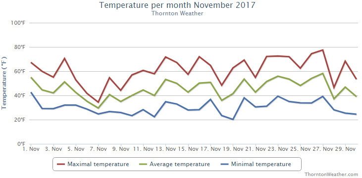
To say November 2017 was simply ‘warm and dry’ in many ways is an understatement. Temperatures were far above normal, our warmest November in the past 10 years in fact. It also was exceedingly dry with little precipitation and snow seen.
The month started off mild then cooled off for a few days from the 6th to the 9th. After that though, the vast majority of readings were above normal, some much higher than average.
Here in Thornton, we saw an average monthly temperature of 44.1 degrees. That is 4.7 degrees above our running 10-year average. Temperatures for us ranged from a high of 77.6 degrees on the 27th down to a low of 20.2 on the 19th.
Denver’s official average came in a bit warmer at 45.3 degrees. That was well above the Mile High City’s November average of 38.3 degrees. A reading of 81 degrees on the 27th and 22 degrees on the 15th were the highest and lowest readings at DIA.
Denver set two daily high temperature records. On the 26th, as measured at Denver International Airport, the temperature topped out at 74 degrees, a record high for the date. This was followed the next day with a record high setting of 81 degrees. The reading on the 27th also set a record for the warmest November ever on record.
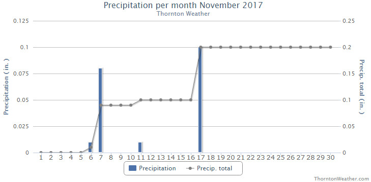
In terms of precipitation, what little we saw came during the first half of the month. Thornton saw a mere 0.20 inch in the bucket. The airport saw a bit more with 0.29 inches. Both fall well short of Denver’s long term November precipitation average of 0.61 inches.
Snow was certainly lacking for the month as well. In Thornton we saw 0.8 inches on the 7th, our only measurable snowfall of the entire month. Denver officially only recorded a trace. This is in stark contrast to Denver’s long term November snowfall average of 8.7 inches.
Click here to view Thornton’s November 2017 climate report.
From the National Weather Service:
CLIMATE REPORT
NATIONAL WEATHER SERVICE DENVER/BOULDER CO
733 AM MST FRI DEC 1 2017

...................................

...THE DENVER CO CLIMATE SUMMARY FOR THE MONTH OF NOVEMBER 2017...

CLIMATE NORMAL PERIOD 1981 TO 2010
CLIMATE RECORD PERIOD 1872 TO 2017

WEATHER         OBSERVED          NORMAL  DEPART  LAST YEAR`S
                 VALUE   DATE(S)  VALUE   FROM    VALUE  DATE(S)
                                          NORMAL
................................................................
TEMPERATURE (F)
RECORD
 HIGH              81   11/27/2017
 LOW              -18   11/29/1877
HIGHEST            81R  11/27        73       8       80  11/16
LOWEST             22   11/15        -6      28       10  11/30
                        11/12
AVG. MAXIMUM     61.1              52.1     9.0     59.9
AVG. MINIMUM     29.4              24.5     4.9     30.4
MEAN             45.3              38.3     7.0     45.1
DAYS MAX >= 90      0               0.0     0.0        0
DAYS MAX <= 32      0               2.3    -2.3        1
DAYS MIN <= 32     22              23.4    -1.4       15
DAYS MIN <= 0       0               0.6    -0.6        0

PRECIPITATION (INCHES)
RECORD
 MAXIMUM         3.21   1946
 MINIMUM            T   1899
                        1901
                        1949
TOTALS           0.29              0.61   -0.32     0.52
DAILY AVG.       0.01              0.02   -0.01     0.02
DAYS >= .01         3               4.7    -1.7        2
DAYS >= .10         1               1.6    -0.6        2
DAYS >= .50         0               0.0     0.0        0
DAYS >= 1.00        0               0.0     0.0        0

GREATEST 24 HR. TOTAL    0.23   11/17 TO 11/17

SNOWFALL (INCHES)           T       8.7

SNOWFALL (INCHES) RECORDS TOTAL    42.5    1946

DEGREE_DAYS
HEATING TOTAL     586               801    -215      586
 SINCE 7/1       1171              1382    -211      896
COOLING TOTAL       0                 0       0        0
 SINCE 1/1        881               769     112      878

FREEZE DATES
RECORD
 EARLIEST     09/08/1962
 LATEST       06/08/2007
EARLIEST                        10/07
LATEST                          05/05
.................................................................

WIND (MPH)
AVERAGE WIND SPEED              9.7
RESULTANT WIND SPEED/DIRECTION   3/214
HIGHEST WIND SPEED/DIRECTION    39/350    DATE  11/18
HIGHEST GUST SPEED/DIRECTION    52/270    DATE  11/01

SKY COVER
POSSIBLE SUNSHINE (PERCENT)   MM
AVERAGE SKY COVER           0.50
NUMBER OF DAYS FAIR            5
NUMBER OF DAYS PC             21
NUMBER OF DAYS CLOUDY          4

AVERAGE RH (PERCENT)     50

WEATHER CONDITIONS. NUMBER OF DAYS WITH
THUNDERSTORMS             0     MIXED PRECIP             0
HEAVY RAIN                0     RAIN                     0
LIGHT RAIN                1     FREEZING RAIN            0
LT FREEZING RAIN          1     HAIL                     0
HEAVY SNOW                0     SNOW                     0
LIGHT SNOW                3     SLEET                    0
FOG                      10     FOG W/VIS <= 1/4 MILE    4
HAZE                      6

-  INDICATES NEGATIVE NUMBERS.
R  INDICATES RECORD WAS SET OR TIED.
MM INDICATES DATA IS MISSING.
T  INDICATES TRACE AMOUNT.
Thornton’s December preview: Will there be an end to the mild, dry conditions?
 November proved to be an extraordinarily warm and dry month. Does December have hope for relief?
The month of December brings with it the official start of winter and oftentimes, colder and snowier weather conditions.
It however can also offer unseasonably warm temperatures and bone dry conditions. Given our recent mild and dry weather, we are certainly hoping for a change in the coming month.
Overall December’s monthly mean temperature of 30.0 degrees (1981 – 2010 averages) makes it our coldest month. Snow is always on everyone’s mind this time of year but December is only our 3rd snowiest month behind March and November with an average of 8.5 inches of the white stuff.
Denver sets record high for November 27, highest temp ever recorded in November
 A double shot of high temperature records for the Mile High City today.
As measured at Denver International Airport, Denver saw a high today of 81 degrees at 12:56pm. This easily bested the record high temperature for November 27 of 74 degrees set in 1950 and 1903.
Additionally, the 81 degree reading is the warmest reading ever seen in the month of November. The old record was 80 degrees on the 8th of 2006 & the 16th of 2016.
Of course the key to all of the above is the “as measured at Denver International Airport.” Since moving Denver’s official weather station to the airport far east of its historical locations, we have seen similar occurrences of temperature extremes that don’t mate up with stations close to the city.
Today for example, the station at the Denver City Park recorded a high of 78 degrees. Still a record but a far cry from what the airport reported. As a result, these new records really should come with an asterisk.
Here in Thornton, we saw a high of 77.5 degrees at 1:24pm.
Pretty big changes are on the way tonight when a cold front arrives. That will send temperatures down and bring us a chance for snow overnight. Details in the extended forecast here.
November 2017 top shots: Monthly photo slideshow

Typically November is a quiet weather month with plenty of nice, fall days but it can also turn wet with healthy doses of snow and moisture. The wide variety of conditions can create picturesque scenes ranging from blue skies and snow-capped mountains to a wintry wonderland in the metro area.
November is the second snowiest month of the year so winter conditions are not unusual. Typically though, these bouts of cold are short-lived and normal daytime conditions are pleasant.
Outdoor activities continue to be quite popular during the month. The cooling temperatures do oftentimes lead to an increase in wildlife activity.
All of the above help lead to a month in which a wide variety of scenes, flora and fauna can be captured.
- Slideshow updated November 26, 2017
- To learn more about how to send your photo to us for inclusion in the slideshow, see below the slideshow.
Showcasing images captured by ThorntonWeather.com readers as well as some of our own, our monthly slideshow covers the entire gamut of weather-related imagery.
Sunsets, sunrises, wildlife and of course every type of weather condition are vividly depicted in images captured from yours and our cameras.
| [flickr_set id=”72157666065676609″] |
What is missing in the slideshow above? Your photo!
Our monthly photo slideshow is going to feature images that we have taken but more importantly images that you have captured. The photos can be of anything even remotely weather-related.
Landscapes, current conditions, wildlife, pets, kids. Whimsical, newsy, artsy. Taken at the zoo, some other area attraction, a local park, a national park or your backyard. You name it, we want to see and share it!
Images can be taken in Thornton, Denver or anywhere across the extraordinary Centennial State. We’ll even take some from out of state if we can tie it to Colorado somehow.
We’ll keep the criteria very open to interpretation with just about any image eligible to be shown in our slideshows.
What do you win for having your image in our slideshow? We are just a ‘mom and pop’ outfit and make no money from our site so we really don’t have the means to provide prizes. However you will have our undying gratitude and the satisfaction that your images are shared on the most popular website in Thornton.
To share you images with us and get them included in the slideshow just email them to us or share them with ThorntonWeather.com on any of the various social media outlets. Links are provided below.
So come on, get those camera’s rolling!
- Email: info@ThorntonWeather.com
- Facebook: https://www.facebook.com/ThorntonWeather
- Google+: https://plus.google.com/+Thorntonweather
- Twitter: @ThorntonWeather (https://twitter.com/thorntonweather)
Denver sets record high temperature for November 26
The unusually warm temperatures we have seen this month definitely make it hard to believe we are now at the end of November. Today continued the trend as the mercury climbed into record-setting territory.
At 2:16pm the temperature topped out at 74 degrees at Denver’s official station at Denver International Airport. These easily bested the record high temperature for the date of 72 degrees set in 1998.
Here in Thornton we were just a touch warmer with a high of 74.5 degrees.
The temperatures today continue the trend of a very warm, dry November. Currently, the overall average temperature for the month is running nearly five degrees above normal.
Tomorrow looks to bring another unseasonably warm and possibly record setting day. See the extended forecast here.
November 26 to December 2: This week in Denver weather history
Cold, snow and wind are the dominant conditions we see in our look back at this week in Denver weather history. All three are common this time of year and extremes with those conditions seem to be unusually common as well.
Among the highlights are numerous high wind events that not only caused damage but also injury to unprepared residents. Significant snowfall also appears many times including a storm in 1983 that shut down the city for the Thanksgiving weekend and left snow on the ground for 63 days.
- Stay up to date with Thornton’s weather: ‘Like’ us on Facebook, follow us on Twitterand add us to your Google+ circles
From the National Weather Service:
25-26
In 1887…snowfall totaled 2.9 inches in the city. This was the only measurable snow of the month. Northeast winds were sustained to 18 mph on the 26th when the temperature dipped to 12 degrees below zero.
In 1959…a sharp cold front produced a northwest wind gust to 51 mph…followed by snow and falling temperatures from a high of 60 degrees to a low of 23 degrees at midnight on the 25th. Snowfall totaled 4.4 inches at Stapleton Airport before ending early on the 26th.
In 1972…winds gusted to 104 mph at the Rocky Flats plant south of Boulder. Gusts to 70 mph were recorded at the National Bureau of Standards in Boulder…while in downtown Boulder winds peaked to 68 mph. Some damage was reported. Northwest winds gusted to 47 mph at Stapleton International Airport on the 26th.
In 1984…blowing snow closed I-70 east of Denver…stranding over a thousand travelers in Limon. Denver received only 2.3 inches of snowfall. North winds gusted to 31 mph at Stapleton International Airport.
In 1999…strong Chinook winds redeveloped overnight in and near the foothills. Peak wind gusts included 72 mph atop Blue Mountain near Wondervu and at the National Center for Atmospheric Research mesa lab above Boulder.
25-27
In 1978…heavy snowfall of 6.0 inches was measured at Stapleton International Airport where north winds gusted to 20 mph. Most of the snow…4.8 inches…fell on the 25th. The greatest amount of snow measured on the ground was 5 inches due to settling and melting.
25-28
In 1952…the average coldest 4-day period in November in the previous 81 years of record occurred. Maximum temperatures of 19…15…21…and 25 degrees were recorded. Minimum temperatures were below zero each day with readings of 7 below…6 below…5 below…and 6 below.
25-29
In 1985…dense fog with visibilities as low as 1/8 mile occurred on five consecutive days at Stapleton International Airport. The fog was at times accompanied by light snow… Light freezing drizzle…or ice crystals. Fog occurred all day on both the 26th and 29th.
26
In 1873…west winds increased to a violent gale at 3:00 am and reached a maximum sustained velocity of 56 mph at 3:15 am. The winds continued with a velocity of not less than 40 mph until 6:00 am. Winds continued brisk for the remainder of the day. The strong winds caused damage to houses and buildings in the city. Temperatures were in the 50’s through early afternoon with a recorded high of 59 degrees. Winds also blew strongly in Boulder and caused 300 dollars in damage.
In 1911…post-frontal northeast winds were sustained to 43 mph with gusts as high as 52 mph. Snowfall was only 0.5 inch.
In 1965…post-frontal snowfall totaled 5.5 inches at Stapleton International Airport where strong west winds gusted to 39 mph during the afternoon.
In 1976…2 to 4 inches of snow with an arctic cold front produced near zero visibility at times in blowing snow… Causing multiple automobile accidents in metro Denver. Snowfall totaled 3.5 inches at Stapleton International Airport where north winds gusted to 39 mph. Temperatures hovered in the teens and lower 20’s most of the day dipping to 7 degrees by midnight.
In 1977 a strong wind storm raked metro Denver. High winds blew windows from office towers in Denver and Boulder. Thirteen people were injured in Boulder due to flying debris. Wind gusts to 119 mph were clocked on Davidson Mesa southeast of Boulder…with 109 mph in downtown Boulder. Six airplanes were damaged at Jefferson County Airport near Broomfield. Winds to 90 mph were reported in Lakewood. Glass was blown out of several vehicles in Wheat Ridge…and roofs were blown off 4 houses in Arvada. Several houses under construction collapsed across metro Denver. Winds to 75 mph were reported at the Denver Federal Center with 90 mph at Rocky Flats. West winds gusted to 51 mph at Stapleton International Airport. Total insured damage from the wind storm was 2.2 million dollars.
In 1987…a thanksgiving snowstorm brought 5 inches of snow to metro Denver and 6 inches to the foothills. At Stapleton International Airport…snowfall totaled 5.0 inches…north winds gusted to 22 mph…and temperatures hovered in the upper 20’s most of the day.
In 1991…strong winds were recorded in and near the eastern foothills. Winds at Rollinsville were clocked to 70 mph with 45 mph recorded in Boulder and 51 mph at the U.S. Atomic Energy Commission Rocky Flats plant. West winds gusted to only 28 mph at Stapleton International Airport.
26-27
In 1876…heavy snowfall totaled 9.0 inches over the city from 5:00 pm on the 26th through 5:00 p.m. on the 27th. Precipitation was 0.30 inch on the 25th and 0.60 inch on the 27th.
In 1919…an incursion of cold arctic air produced snowfall of 4.6 inches over downtown Denver. Temperatures dipped to 5 degrees below zero on the evening of the 26th and recovered to a high of only 1 degree below zero on the 27th…the all-time record low maximum for the month of November and the record for the date. Northwest winds were sustained to 25 mph with gusts to 26 mph on the 26th.
In 1923…snowfall of 2.0 inches was the only snow of the month. North winds were sustained to 22 mph on the 26th.
In 1972…heavy snowfall totaled 7.5 inches at Stapleton International Airport where north winds gusted to only 18 mph on the 27th.
In 1983…a Thanksgiving blizzard dumped 21.5 inches of snowfall in 37 hours with a maximum of 18 inches on the ground at Stapleton International Airport. The storm produced howling winds…which paralyzed Thanksgiving weekend transportation across all of eastern Colorado. On the 27th…Stapleton International Airport closed… Opening 24 hours later. Interstate highways were closed in all directions…but west…from Denver. At Stapleton International Airport…north winds gusted to 36 mph on the 26th and to 29 mph on the 27th. However…most wind speeds across metro Denver were 15 to 30 mph. Temperatures hovered in the teens and lower 20’s. Many stores and businesses closed. Several high school football games were postponed. Across metro Denver…snow depth varied from 15 inches in Commerce City to 28 inches near Chatfield Reservoir. Snow removal in Denver was estimated at 1.5 million dollars. Following the storm… An inch or more of snow remained on the ground for 63 consecutive days through January 27…1984. This is the longest period of continuous snow cover ever recorded in Denver.
In 1990…an early winter storm deposited 2 to 8 inches of wet snow across metro Denver. Snowfall totaled 3.4 inches at Stapleton International Airport where northeast winds gusted to 30 mph on the 26th.
In 1993…strong winds swept off the foothills across metro Denver. Sustained winds of 30 to 50 mph were common across the area. Wind gusts to 67 mph were recorded atop Squaw Mountain near Idaho Springs. West winds gusted to 36 mph at Stapleton International Airport on the 26th. The strong winds produced some blowing snow…reducing the visibility to less than one mile at times.
In 1995…snowfall totaled 3.7 inches at the former Stapleton International Airport site. The foothills west of Denver received 4 to 7 inches of snow. North-northeast winds gusted to 34 mph at Denver International Airport on the 26th.
27
In 1965…strong winds buffeted Boulder…causing 11 thousand dollars in damage. Wind gusts to 75 mph were recorded downtown. West winds gusted to 38 mph at Stapleton International Airport.
In 1994…winds gusted to 87 mph atop Squaw Mountain…5 miles south of Idaho Springs…and to 84 mph on Fritz Peak near Rollinsville in the foothills southwest of Boulder. Northwest winds gusted to 40 mph at Stapleton International Airport.
28
In 1884…a windstorm during the afternoon produced northwest sustained winds to 46 mph. Two wooden slats were blown out of the weather instrument shelter…and nearly all of the slats on the north and west sides were loosened.
In 1898…northwest winds were sustained to 50 mph with gusts as high as 80 mph.
In 1902…northwest winds were sustained to 40 mph with gusts to 48 mph. The strong apparent Bora winds warmed the temperature to a high of only 40 degrees.
In 1904…northwest winds sustained to 44 mph with gusts to 58 mph warmed the temperature to a high of 58 degrees.
In 1927…strong west winds occurred in Boulder…causing widespread minor damage. A wind gust to 65 mph was recorded at Valmont east of Boulder. The west winds possibly produced a cyclonic twist.
In 1928…heavy snowfall totaled 7.0 inches over downtown Denver.
In 1957…a vigorous cold front produced north-northeast wind gusts to 54 mph at Stapleton Airport. Light snow following the front totaled only 0.2 inch.
In 1970…strong Chinook winds reached 77 mph in downtown Boulder.
In 1978…wind gusts 60 to 90 mph were reported in and near the foothills.
In 1984…high winds of 60 to 80 mph occurred along the Front Range eastern foothills.
In Boulder…the high winds blew the roof off a service station. Several trees were felled… Damaging some cars. An elderly woman was injured when she was knocked down by a wind gust and blown 20 feet into some bushes. Northwest winds gusted to 36 mph at Stapleton International Airport.
In 1994…winds gusted to 72 mph in Boulder. No damage was reported. Northwest winds gusted to 35 mph at Stapleton International Airport.
Continue reading November 26 to December 2: This week in Denver weather history
Weather Geek Stuff for the weather enthusiast on your shopping list

Not everyone gets excited about blizzards, tornadoes, hurricanes and other types of extreme weather but many folks out there are passionate about Mother Nature. Weather Geek Stuff is an online shop just for those whose hearts race with the thrill of severe weather and they are offering special deals through the holiday season.
Weather Geek Stuff is an online store that provides a host of clothing items and novelties just for weather buffs. From the store’s custom ‘Weather Geek’ and ‘Weather Diva’ logoed merchandise to items imprinted with amusing weather warnings signs as well as Skywarn storm spotter logos, there is something there sure to please any weather lover.
Weather Geek Stuff’s merchandise was shown on the Weather Channel as a recommended gift so you know the quality is good. Stu Ostro, Weather Channel’s Senior Director of Weather Communications even sports a ‘Weather Geek’ t-shirt on his Twitter profile.
Kids and dogs aren’t left out of the weather fun either. There is a wide variety of clothing items sized just right for the little ones from babies to bigger kids. Canine companions as well can get shirts and bowls emblazoned with a weather-related logo.
The selection goes far beyond clothing too. Water bottles, clocks, mugs, bags and other novelties are part of the store’s offerings. For the tech types, cases for iPhones and iPads are available. Recently added products include laptop skins, clipboards and throw blankets.
Support ThorntonWeather .com
Weather Geek Stuff is owned and operated by the same folks that run ThorntonWeather.com. We provide ThorntonWeather.com as a no-cost service to the community and use the minimal amount of money made from Weather Geek Stuff to support the costs of running this website and the associated equipment. So remember, if you have a weather buff on your shopping list, by buying from Weather Geek Stuff you are supporting ThorntonWeather.com! You can also donate directly to fund the site here.
