|
All posts by Thornton Weather
Watch Beautiful Snow Tornado Blow Through a Picturesque Austrian Village
|
Denver ties record high temperature for January 18
 We knew today was going to be unseasonably warm and the numbers backed that up.
The National Weather Service reports that Denver’s high temperature today, as measured at Denver International Airport, topped out at 65 degrees. That matches the record high temperature for the date last set in 1920.
Here in Thornton, we were a bit cooler with a high of 62.8 degrees.
With high temperatures tomorrow expected to reach similar heights, we may set another record Friday. The record high for January 19 is 68 degrees last set in 1986.
Philippine volcano ‘fireworks’ draw tourists as residents flee
|
January 7 to January 13: This Week in Denver Weather History

January in Colorado is known for two main weather conditions – cold and wind. Our look back at this week in Denver weather history shows why this reputation is well earned.
From the National Weather Service:
31-7
In 1941…a protracted cold spell through January 7…1942… Produced below zero low temperatures on 7 of the 8 days. A low temperature of 2 degrees on the 3rd prevented a string of 8 days below zero. The coldest days during the period were the 1st with a high of 2 degrees and a low of 9 degrees below zero…the 4th with a high of 2 degrees and a low of 11 degrees below zero…and the 5th with a high of 26 degrees and a low of 12 degrees below zero.
6-7
In 1908…furious high winds were noted in Boulder but caused only minor damage and injury.
In 1913…a very cold arctic air mass caused temperatures to plunge to record levels. The low temperature fell to 21 degrees below zero on the 6th and to 18 degrees below zero on the 7th…both records. The high temperature of only 8 degrees below zero on the 6th was a record low maximum for the date.
In 1920…post-frontal heavy snowfall totaled 7.0 inches in downtown Denver. North winds were sustained at 24 mph with gusts to 30 mph on the 6th.
In 1923…warm Chinook winds resulted in two temperature records. Low temperatures of 37 degrees on the 6th and 42 degrees on the 7th equaled the record high minimums for the dates. West winds were sustained to 30 mph with gusts to 33 mph on the 6th. Southwest winds were sustained to 47 mph with gusts to 52 mph on the 7th. High temperatures were 53 degrees on the 6th and 56 degrees on the 7th.
In 1986…2 to 4 inches of snow fell over metro Denver… With 5 to 8 inches in the foothills west of the city. The 2.4 inches of snowfall recorded at Stapleton International Airport was the only snowfall of the month. Northwest winds gusted to 24 mph at the airport.
In 2006…a brief warm spell resulted in two temperature records. High temperatures of 66 degrees on the 6th and 69 degrees on the 7th equaled the record daily maximum temperatures for each of those days. Low temperatures remained above freezing and were within 1 or 2 degrees of the record daily high minimums.
7
In 1911…west Chinook winds were sustained to 51 mph and warmed the temperature to a high of 56 degrees.
In 1994…occasional high winds buffeted the eastern foothills. Wind gusts to 99 mph were recorded at Rollinsville…southwest of Boulder. West winds gusted to 40 mph at Stapleton International Airport.
In 1995…a brief blast of high winds hit the eastern foothills and adjacent Front Range communities. A wind gust to 112 mph was recorded atop Squaw Mountain…west of Denver. In Boulder…winds gusted to 81 mph. West winds gusted to 31 mph at Stapleton International Airport.
In 2009…damaging downslope winds were responsible for triggering two wildfires that threatened the city of Boulder. Peak wind gusts ranged from 75 to 107 mph in and near the foothills of Boulder…Jefferson and park counties. Although the fires never merged…they were close enough for firefighters to build a perimeter around both of them. The fires quickly torched 3000 acres and forced the evacuation of up to 1400 families. One home was destroyed along with several barns and outbuildings. Three firemen suffered minor injuries. In Bailey…power lines were downed by falling trees. A tin roof on an auto repair shop in town was almost completely blown off. Peak wind gusts included: 107 mph…3 miles south of Mt. Audobon…92 mph…3 miles south of Evergreen; 87 mph…6 miles northwest of Boulder; 81 mph…2 miles east-northeast of Bergen Park and at the National Wind Technology Center; 79 mph…4 miles northeast of Nederland; 77 mph…3 miles west of Sheridan; 75 mph at Genesee. A peak wind gust of 39 mph was measured at Denver International Airport from the west.
7-8
In 1911…gale force winds occurred in Boulder causing minor injuries.
In 1937…cold arctic air plunged temperatures below zero for an estimated 56 consecutive hours. Two temperature records were set. High temperatures of 8 degrees below zero on the 7th and 3 degrees on the 8th were record low maximum readings for those dates. Low temperatures plunged to 12 degrees below zero on the 7th and 11 degrees below zero on the 8th. Snowfall was 1.4 inches in downtown Denver.
In 1969…a violent evening windstorm struck Boulder and the adjacent foothills. A wind gust to 130 mph was recorded at the National Center for Atmospheric Research. Winds reached 96 mph in downtown Boulder. The Boulder airport wind recorder was blown away after measuring a wind gust to 80 mph. The windstorm caused over one million dollars in damage and one fatality in Boulder. About 25 homes in south Boulder had roofs blown off or were severely damaged. Roofs were blown off buildings housing scientific laboratories and offices of the Environmental Science Services Administration…now NOAA…in Boulder…and installations of several scientific measuring sites near Boulder received heavy damage. Grass fires driven by the high winds endangered many areas…but were controlled by volunteer firemen. One man died from injuries received when he was blown from a fire truck. One man was killed and another injured when the truck camper in which they were riding was blown off I-25 about 10 miles north of Denver. In the same area a mobile home and a truck trailer were blown off the highway and demolished. At least 20 people in the Boulder area received light to serious injuries from flying debris or from being blown into obstructions. Power lines and trees were downed over a wide area. Damage was relatively light in the city of Denver…where northwest winds gusted to 62 mph at Stapleton International Airport on the 8th. Many windows were broken in Arvada…Englewood…and Littleton. A 27-year-old fire lookout tower on Squaw Mountain…west of Denver…was blown away…and several radio relay towers at that location were toppled. Trucks were overturned near Georgetown. Mobile homes were overturned in several areas with occupants receiving injuries in some cases. The strong Chinook winds also brought warm weather. The maximum temperature of 69 degrees on the 7th broke the old record of 65 degrees set in 1948. The temperature also reached 65 degrees on the 8th…but was not a record.
In 1992…an intense blizzard buried eastern parts of metro Denver. At times snow fell at rates of 2 to 3 inches an hour. Winds increased from the north at speeds of 25 to 45 mph. Drifts of 4 to 8 feet were common. I-70 was closed east of Denver…and I-25 was closed from Denver south. Snowfall totals ranged from a couple of inches in the foothills west of Denver to as much as 2 feet on the east side of metro Denver. The heaviest snow fell on the 7th in a band from the northern suburbs of Westminster and Thornton through Aurora and east Denver to southeast of Parker. Snowfall totals included: 22 inches in southeast Aurora…14.8 inches at Stapleton International Airport…13 inches in Northglenn…10 inches in Parker…and 9 inches in Westminster. The 14.5 inches of snowfall measured on the 7th into the 8th is the greatest 24 hour snowfall ever recorded in the city during the month of January. North winds gusting to 46 mph caused much blowing snow at Stapleton International Airport.
In 2000…high winds developed in and near the Front Range foothills. The strongest winds were generally confined to foothills areas north of I-70. A wind gust to 76 mph was reported in Golden Gate Canyon. West winds gusted to 37 mph at Denver International Airport on the 8th.
7-10
In 1962…a major winter storm dumped 13.5 inches of snow on metro Denver. A foot of the snow fell on the 8th when northeast winds gusted to 30 mph. The storm was followed by an intense blast of very cold arctic air. Minimum temperature readings of 24 degrees below zero occurred on both the 9th and 10th. The temperature never reached above zero on the 9th when a maximum reading of 1 degree below zero was recorded. Temperatures were below zero for 37 consecutive hours.
8
In 1912…northwest winds were sustained to 40 mph with gusts to 45 mph in downtown Denver.
In 1971…wind gusts to 52 mph were recorded in downtown Boulder. Northwest winds gusted to 28 mph at Stapleton International Airport.
In 1990…high winds gusting from 50 to 90 mph along the Front Range produced much damage from blowing dust and gravel throughout the day. Wind gusts to 92 mph were recorded in the Table Mesa area of southwest Boulder. The winds caused sporadic power outages. Clouds of dust and gravel whipped by 70 to 90 mph gusts blinded commuters on the Denver-Boulder Turnpike near Broomfield during the morning rush hour. Flying gravel shattered windows on 50 vehicles parked near a Boulder high school. High winds were also blamed for partially dismantling a house under construction in Boulder…as well as toppling a number of fences…billboards…signs…and power poles. The strong cross-winds jack-knifed and overturned semi-tractor trailers on I-70 near Golden and just south of Boulder on State Highway 93. Several county airports were closed due to strong winds and blowing dust reducing visibilities. Wind delays up to 30 minutes occurred at Stapleton International Airport where west winds gusted to 48 mph. Eighty mph winds in Georgetown…Empire…and Idaho Springs were blamed for power and telephone outages. Windows were blown out of a sheriff’s car along I-70 east of Georgetown. The strong Chinook winds warmed the temperature to a high of 60 degrees in Denver.
In 2007…strong winds associated with an intense upper level jet…and a very strong surface pressure gradient…developed in and near the Front Range foothills. Peak wind gusts ranged from 77 mph to 115 mph. The strong winds coupled with freshly fallen snow resulted in whiteout conditions and several highway closures due to blowing and drifting snow. Road closures included: State Highway 93 between Golden and Boulder; State Highway 128 from Wadsworth Boulevard to State Highway 93; U.S. Highway 36…the Denver Boulder Turnpike from Broomfield to South Boulder Road; and State Highway 74 near Evergreen…between County Road 65 and Lewis Ridge Road. More than 100 people were stranded in their cars between Golden and Boulder as blowing and drifting snow made the highway impassable. Snow drifts along State Highway 93 were over 6 feet in depth. As a result… The American Red Cross opened a shelter at Arvada West High School for the stranded commuters. Up to twenty cars were also abandoned along the Diagonal Highway…between Boulder and Longmont. Thirty vehicles were stranded along State Highway 128. The high winds also caused intermittent power outages in Boulder. West winds gusted to 40 mph at Denver International Airport
8-9
In 1891…heavy dry snowfall totaled 9.7 inches over downtown Denver. Most of the snow…6.5 inches…occurred on the 8th when north winds were sustained to 12 mph with gusts to 20 mph.
In 1939…heavy snowfall totaled 6.7 inches in downtown Denver. The snowfall was the heaviest overnight…particularly during the early morning hours. The moist snow adhered to the north side of the instrument shelter and other objects to a depth of 2 inches. Snow accumulated on fences and trees to several inches. This was the greatest snowfall of the month that year. The greatest depth on the ground was 6.5 inches. North to northwest winds were sustained to 24 mph on the 8th and to 27 mph on the 9th.
8-10
In 1983…winds of 70 to 90 mph howled through Boulder. A wind gust to 100 mph was recorded on Fritz Peak near Rollinsville. A tree blown down by the wind damaged a house in eastern Boulder County. The strong winds developed behind a cold front late on the 8th and continued through the 10th. At Stapleton International Airport…west to northwest winds gusted to 49 mph on the 8th…to 45 mph on the 9th…and to 48 mph on the 10th.
Continue reading January 7 to January 13: This Week in Denver Weather History
Al Gore under fire for climate change claim on bomb cyclone icy storm
|
December 2017 recap: Despite cold finish, month was warmer and drier than average
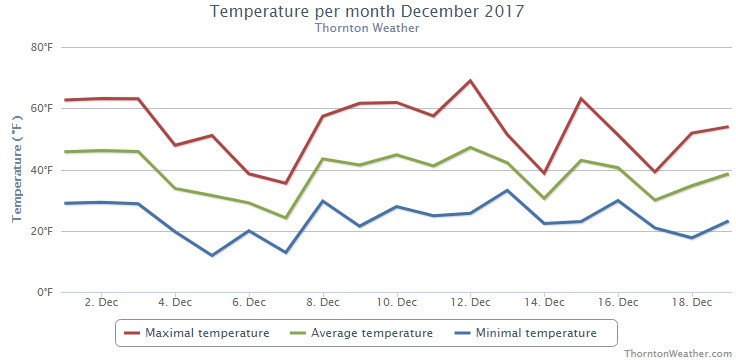
With the last part of December fresh in our minds, it would not be surprising to think of the month as a cold one. However, reaching back, if you recall, we actually enjoyed a lot of mild days earlier and very little precipitation. As a result, December 2017 goes into the books as a warm and dry one.
The first half of the month was notable for stable conditions yielding above normal temperatures and no precipitation. Denver set a record high temperature on the 12th of 69 degrees which was also our warmest reading of the month.
Not long after the warmth came the cold. Arctic air infiltrated from the north on the 21st resulting in much cooler temperatures and a pre-Christmas snow. This was followed by another snow on the 23rd that lasted into the early morning hours of Christmas Eve. Single digit lows were seen for seven days from the 21st to the 27th.
We then saw a brief warmup for the 27th to the 29th but that was short lived. We closed out the month with the final two days’ high temperatures failing to reach even the freezing mark.
On average, Denver’s temperature for December comes in at 30.0 degrees. Both Thornton and the Mile High City came in above that with average readings of 31.8 degrees and 33.2 degrees respectively.
Thornton saw its warmest temperature reading of 69.1 degrees on the 12th and its coldest of 1.6 degrees on the morning of the 27th. Denver’s warmest reading of 69 degrees also came on the 12th and its coldest of -4 degrees came on the 24th.
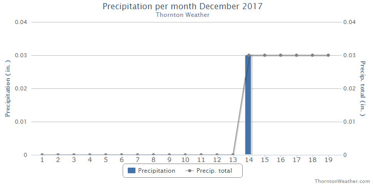
In terms of precipitation, Thornton saw a mere 0.16 inch of liquid in its bucket for the month. Denver was a bit better with 0.21 inches. Both were below the long-term Denver average of 0.35 inches.
December on average brings 8.5 inches of snowfall to Denver. Thornton fell well short of that with 4.7 inches and Denver just a bit less with 4.0 inches.
Click here to view Thornton’s December 2017 climate report.
CLIMATE REPORT
NATIONAL WEATHER SERVICE DENVER/BOULDER CO
645 AM MST MON JAN 1 2018

...................................

...THE DENVER CO CLIMATE SUMMARY FOR THE MONTH OF DECEMBER 2017...

CLIMATE NORMAL PERIOD 1981 TO 2010
CLIMATE RECORD PERIOD 1872 TO 2017

WEATHER         OBSERVED          NORMAL  DEPART  LAST YEAR`S
                 VALUE   DATE(S)  VALUE   FROM    VALUE  DATE(S)
                                          NORMAL
................................................................
TEMPERATURE (F)
RECORD
 HIGH              79   12/05/1939
 LOW              -25   12/22/1990
                        12/24/1876
HIGHEST            69   12/12        62       7       65  12/30
LOWEST             -4   12/24        -4       0      -15  12/17
AVG. MAXIMUM     48.3              42.8     5.5     42.7
AVG. MINIMUM     18.0              17.1     0.9     12.9
MEAN             33.2              30.0     3.2     27.8
DAYS MAX >= 90      0               0.0     0.0        0
DAYS MAX <= 32      4               5.8    -1.8        6
DAYS MIN <= 32     28              29.4    -1.4       30
DAYS MIN <= 0       1               2.0    -1.0        4

PRECIPITATION (INCHES)
RECORD
 MAXIMUM         5.21   1913
 MINIMUM         0.00   1881
TOTALS           0.21              0.35   -0.14     0.78
DAILY AVG.       0.01              0.01    0.00     0.03
DAYS >= .01         4               4.1    -0.1        6
DAYS >= .10         1               1.1    -0.1        2
DAYS >= .50         0               0.1    -0.1        0
DAYS >= 1.00        0               0.0     0.0        0
GREATEST
 24 HR. TOTAL    0.10   12/23 TO 12/23
 STORM TOTAL     0.10   12/23 TO 12/23

SNOWFALL (INCHES)
RECORDS
 TOTAL           57.4   1913
TOTALS            4.0   2017        8.5

DEGREE_DAYS
HEATING TOTAL     979              1086    -107     1146
 SINCE 7/1       2150              2468    -318     2042
COOLING TOTAL       0                 0       0        0
 SINCE 1/1        881               769     112      878

FREEZE DATES
RECORD
 EARLIEST     09/08/1962
 LATEST       06/08/2007
EARLIEST                        10/07
LATEST                          05/05
.................................................................

WIND (MPH)
AVERAGE WIND SPEED              10.0
RESULTANT WIND SPEED/DIRECTION   2/214
HIGHEST WIND SPEED/DIRECTION    37/270    DATE  12/04
HIGHEST GUST SPEED/DIRECTION    48/280    DATE  12/04

SKY COVER
POSSIBLE SUNSHINE (PERCENT)   MM
AVERAGE SKY COVER           0.50
NUMBER OF DAYS FAIR            8
NUMBER OF DAYS PC             18
NUMBER OF DAYS CLOUDY          5

AVERAGE RH (PERCENT)          49

WEATHER CONDITIONS. NUMBER OF DAYS WITH
FOG OR MIST                   12
FOG VSBY LESS 1/4 MI           4
THUNDER                        0
ICE PELLETS                    0
HAIL                           0
FREEZING RAIN DRIZZLE          0
DUST STORM                     0
SMOKE OR HAZE                  5
BLOWING SNOW                   0
TORNADO                        0

-  INDICATES NEGATIVE NUMBERS.
R  INDICATES RECORD WAS SET OR TIED.
MM INDICATES DATA IS MISSING.
T  INDICATES TRACE AMOUNT.
Thornton’s January 2018 preview: Cold but not always snow for first month of the year
 As we begin the new year the winter chill begins to set in. While January can see its share of extremes, the month historically sees stable temperatures and is usually relatively dry.
January ranks as the second coldest month in Denver next to December with average temperatures remaining virtually the same from the start to the end of the month.
In terms of snowfall, the month only ranks as the fourth snowiest and it is not uncommon for it to be quite dry.
What does January 2018 hold for us? Follow the link to find out.
For the complete January preview including a look at historical averages and extremes, click here.
December 31 to January 6: This week in Denver weather history
One of our coldest and driest months, January is not normally known for its weather extremes. However just like any in Colorado, significant events can occur as we see in our look back at this week in Denver weather history.
From the National Weather Service:
25-31
In 1980…temperatures were unusually warm during the week between Christmas and New Year’s. High temperatures for the week ranged from the mid-50’s to the mid-70’s. Four temperature records were set. Record highs occurred on the 26th with 68 degrees…the 27th with 75 degrees…and the 30th with 71 degrees. A record high minimum temperature of 41 degrees occurred on the 27th.
30-31
In 1886…heavy snow totaled 6.5 inches in downtown Denver. Most of the snow…4.5 inches…fell on the 31st. North winds were sustained to 18 mph.
In 1928…snowfall of 0.6 inch was the only measurable snow of the month in the city.
In 1947…post-frontal heavy snow totaled 6.3 inches over downtown Denver. Most of the snow fell on the 30th. North winds were sustained to 17 mph on the 30th.
In 1995…the foothills west of Denver received 5 to 9 inches of new snow…except for Bailey where 11 inches of snow were measured. No snow fell at the site of the former Stapleton International Airport.
31
In 1890…northeast winds were sustained to 46 mph with gusts as high as 60 mph behind an apparent cold front. A trace of sleet fell.
In 1899…northwest winds were sustained to 44 mph with gusts as high as 48 mph. The Chinook winds warmed the temperature to a high of 49 degrees.
In 1927…the temperature was below zero all day. The high temperature of 3 degrees below zero was a record low maximum for the date. The low temperature was 11 degrees below zero.
In 1970…warm Chinook winds whistled through Boulder. A wind gust to 92 mph was recorded at the National Center for Atmospheric Research…while at the National Bureau of Standards…winds peaked to 70 mph. Northwest winds gusting to 30 mph warmed the temperature to a high of 60 degrees at Stapleton International Airport.
In 1993…occasional high winds occurred northwest of Denver and in the foothills. A wind gust to 85 mph was recorded at Jefferson County Airport in Broomfield. Wind gusts to 86 mph occurred on Squaw Mountain with 75 mph recorded at Rollinsville. West winds gusted to 46 mph at Stapleton International Airport.
In 2011…an intense and fast moving storm system… produced a powerful windstorm across the Front Range. In the mountains and foothills…several locations recorded wind gusts in excess of 100 mph. Numerous trees were knocked down throughout Arapahoe National Forest. One man was killed when he was impaled by a falling tree limb while driving along U.S. Highway 36…north of Boulder. The strong winds produced extensive damage to fences and roofs… and also knocked down trees which resulted in power outages that affected 19 thousand residents along the Front Range. In the mountains and foothills…peak wind gusts included: 111 mph…3 miles south-southeast of Pinecliffe; 101 mph…1 mile west of Lyons; 94 mph atop Berthoud Pass; 86 mph…3 miles south of Golden; 84 mph… 4 miles northwest of Boulder; 81 mph in Boulder; 79 mph at Kenosha Pass…NCAR Mesa Lab and the junction of U.S. Highways 72 and 93; 77 mph at the National Wind Technology Center; and 76 mph…3 miles north-northwest of Morrison. Peak wind gusts for the Urban Corridor included: 80 mph…3 mile east of Cedar Point; 77 mph in north Longmont; 67 mph…10 miles east of Parker; 64 mph at Buckley AFB and Lakewood; 60 mph at Bennett and Front Range Airport in Watkins; 59 mph at Denver International Airport and Deer Trail; 58 mph at Rocky Mountain Regional Airport in Broomfield and 2 miles north-northwest of Louisville.
31-1
In 1900…low temperatures dipped to 19 degrees below zero on both days to establish daily record minimum temperatures.
In 1975…only 4.2 inches of snow fell at Stapleton International Airport…while north of Denver a major blizzard raged. All roads north of Denver into Wyoming were closed when strong winds whipped snow into 5 to 6 foot drifts. North winds gusted to 43 mph at Stapleton International Airport on the 31st…causing some blowing snow. Freezing drizzle also fell on the 31st.
In 1984…heavy snow fell in the foothills with 8 inches at Boulder and 6 inches in southern and western metro Denver. Only 1.5 inches of snow fell overnight at Stapleton International Airport.
In 1991…a New Year’s Eve snow storm dumped 2 to 8 inches of snow across northeastern Colorado. Snowfall totaled 3.4 inches at Stapleton International Airport. The 1.9 inches of snow that fell on the 31st was the only measurable snowfall of the month.
In 2008…another brief period of high winds occurred in and near the foothills of Boulder and Jefferson counties. In Nederland…the strong wind snapped a blue spruce which landed on a nearby propane tank. Some roofs in the immediate area were damaged and power lines were downed; which left 126 residences without electricity for six hours. Peak wind gusts included 90 mph at the national wind technology center…and 89 mph; 6 miles northwest of Boulder. At Denver International Airport…a peak wind gust of 23 mph was measured from the southwest.
31-6
In 1973…the 31st marked the start of a protracted cold spell that extended into January of 1974 when temperatures dipped below zero on 7 consecutive days. Record daily minimum readings occurred on the 3rd and 5th when the temperature plunged to 17 degrees below zero on both days. A record low daily maximum temperature of only 4 degrees occurred on the 5th.
31-7
In 1941…a protracted cold spell through January 7…1942… Produced below zero low temperatures on 7 of the 8 days. A low temperature of 2 degrees on the 3rd prevented a string of 8 days below zero. The coldest days during the period were the 1st with a high of 2 degrees and a low of 9 degrees below zero…the 4th with a high of 2 degrees and a low of 11 degrees below zero…and the 5th with a high of 26 degrees and a low of 12 degrees below zero.
1
In 1875…the temperature fell 27 degrees between 3:00 pm and 5:00 pm. The high for the day was 43 degrees…and the low was 8 degrees. Occasional snow flurries fell during the day…but not enough to cover the ground.
In 1885…dense smoke choked the skies over downtown Denver until midday.
In 1910…a rare trace of light rain fell during the morning.
In 1911…post-frontal northeast winds were sustained to 40 mph. Only a trace of snow fell in downtown Denver.
In 1952…snowfall of 0.03 inch was the only measurable snowfall of the month and resulted in 0.01 inch of melted snow…the only precipitation of the month.
In 1956…west-northwest winds gusted to 52 mph at Stapleton Airport.
In 1996…the first snow storm of the new year dumped more than a foot of snow in the Front Range foothills with 4 to 9 inches across the western and southern sections of metro Denver. Snow totals included: 14 inches at conifer; 11 inches at Evergreen; and 10 inches at Eldora Ski Resort… West of Boulder. Snowfall totaled only 1.2 inches at the site of the former Stapleton International Airport. North- northeast winds gusted to 30 mph at Denver International Airport.
In 2003…only a trace of snow fell at the site of the former Stapleton International Airport. This…along with a trace of snow on the 22nd…was the only snow of the month…which equaled the 1934 record for the least snowiest January.
1-2
In 1896…warm Chinook winds on the 1st became cold bora winds on the 2nd. Southwest winds sustained to 60 mph with gusts as high as 66 mph warmed the temperature to a high of 55 degrees on the 1st. Northwest winds sustained to 54 mph with gusts to 60 mph resulted in snowfall of 0.3 inch and a high temperature of only 31 degrees on the 2nd.
1-5
In 1940…the first days of the month were characterized by a mixture of drizzle…light snow…and fog. Fog occurred on each day. On the 4th and 5th considerable glazing resulted from freezing drizzle. All objects were coated with a glaze on the windward side. This resulted in very slippery streets…which caused several minor traffic accidents. The glaze was not heavy enough to damage wires and cables.
Continue reading December 31 to January 6: This week in Denver weather history
December 2017 top shots: Monthly photo slideshow
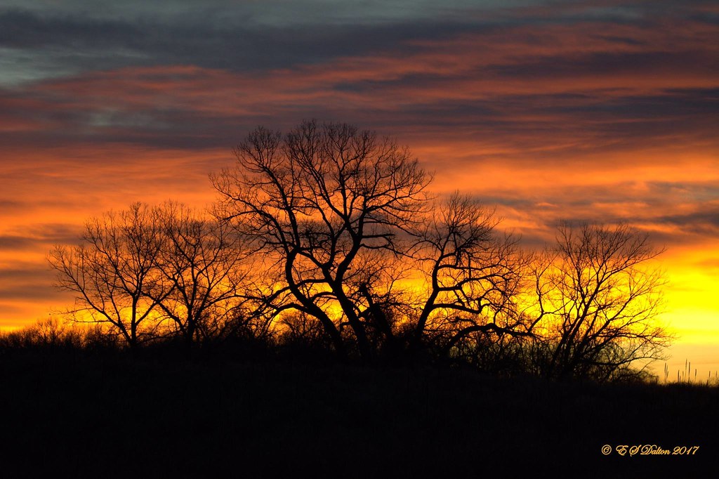
The month of December can offer everything from bone dry conditions to bone chilling cold and monstrous snowstorms. The weather and wildlife all afford an abundance of photo opportunities as our December photo slideshow shows.
Leaves have fallen from trees now and the landscape can sometimes look quite stark. However it only takes a quick shot of snow to change that picture greatly. Throw in gorgeous sunrises and sunsets, plenty of wildlife big and small, kids playing and much more and the month can be quite colorful and eventful.
- Slideshow updated December 30, 2017
- To learn more about how to send your photo to us for inclusion in the slideshow, see below the slideshow.
Showcasing images captured by ThorntonWeather.com readers as well as some of our own, our monthly slideshow covers the entire gamut of weather-related imagery.
Sunsets, sunrises, wildlife and of course every type of weather condition are vividly depicted in images captured from yours and our cameras.
| [flickr_set id=”72157690956339525″] |
What is missing in the slideshow above? Your photo!
Our monthly photo slideshow is going to feature images that we have taken but more importantly images that you have captured. The photos can be of anything even remotely weather-related.
Landscapes, current conditions, wildlife, pets, kids. Whimsical, newsy, artsy. Taken at the zoo, some other area attraction, a local park, a national park or your backyard. You name it, we want to see and share it!
Images can be taken in Thornton, Denver or anywhere across the extraordinary Centennial State. We’ll even take some from out of state if we can tie it to Colorado somehow.
We’ll keep the criteria very open to interpretation with just about any image eligible to be shown in our slideshows.
What do you win for having your image in our slideshow? We are just a ‘mom and pop’ outfit and make no money from our site so we really don’t have the means to provide prizes. However you will have our undying gratitude and the satisfaction that your images are shared on the most popular website in Thornton.
To share you images with us and get them included in the slideshow just email them to us or share them with ThorntonWeather.com on any of the various social media outlets. Links are provided below.
So come on, get those camera’s rolling!
- Email: info@ThorntonWeather.com
- Facebook: https://www.facebook.com/ThorntonWeather
- Google+: https://plus.google.com/+Thorntonweather
- Twitter: @ThorntonWeather (https://twitter.com/thorntonweather)