Global warming or global cooling? There doesn't seem to be a consensus anymore.
While the United States debates whether or not to push climate change legislation this year, the debate on the climate and man’s effect on it continues in the public forum. In recent days two high profile meteorologists have come forth and added their voices to the growing movement of those who reject the ‘consensus’ of the manmade climate change theory.
Many who advocate the manmade climate change theory like Al Gore and James Hansen have said that the ‘science is settled’ and there is no debate to be made on the issue. Despite this, more and more evidence is being released calling into question the very basis of the arguments climate change alarmists make.
The Capital Weather Gang section of the Washington Post is a must read for many weather enthusiasts. Today, meteorologist and Capital Weather Gang writer Matt Rogers outlined his case for questioning the ‘consensus’ of manmade global warming in a ‘top 10’ list.
AccuWeather.com is one of the most popular weather websites on the Internet and a major provider of weather related news and information to media of all types. Joe Bastardi is an Expert Senior Forecaster at AccuWeather and is considered one of the premier meteorologists in the country. Bastardi recently said that those that advocate the manmade climate change theory have a “house of cards that goes up in smoke.”
September 6 to September 12 - This week in Denver weather history.
Colorado weather is certainly varied and this week’s look back at weather history proves that. We have seen everything from deadly lightning, hail and severe winds to even snow during the second week of September.
1-7
In 1978…the temperature reached 90 degrees or more on seven consecutive days with the highest temperature…94 degrees… Recorded on both the 4th and 6th.
3-6
In 1909…rainfall for the 4 days accumulated to 3.97 inches in Boulder…while in Denver rainfall totaled 2.45 inches on the 4th…5th…and 6th.
5-9
In 1988…layers of smoke aloft from large forest fires in Yellowstone National Park completely obliterated the sun at times. At Stapleton International Airport…surface visibility was reduced at times to 5 and 6 miles in smoke.
6
In 1940…a thunderstorm pelted the city with small hail. The storm produced some lightning damage. One woman was stunned by a bolt which struck near her. Heavy rain from the storm raised the level of Cherry Creek by more than 3 feet during the height of the storm. Rainfall downtown was only 0.26 inch.
In 1988…strong winds blew down two houses that were under construction in Castle Rock. Northwest winds gusted to 44 mph at Stapleton International Airport.
In 1993…a man was struck and killed by lightning while standing outside his home in unincorporated Arapahoe County 11 miles south of Denver. Lightning also struck a cabin in Marshdale…20 miles southwest of Denver…which started a fire and damaged one room and a portion of the roof.
In 1995…hail as large as 3/4 inch in diameter fell in Coal Creek Canyon in northern Jefferson County.
In 2001…a thunderstorm dropped 3/4 inch diameter hail in Aurora near Cherry Creek.
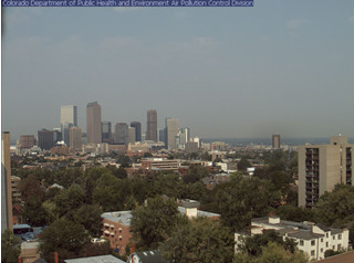
The view of the Rocky Mountains from Denver is obscured by haze caused by smoke from wildfires burning across the western United States.
Update, 5:30pm – The Colorado Department of Public Health and Environment has issued a smoke health advisory for northwest and north-central Colorado. The department warns that residents may wish to limit outside activity, particularly those with heart disease, respiratory illnesses, the very young, and the elderly.
Read the advisory in its entirety at the bottom of this story.
The National Interagency Fire Center (NIFC) reported 17 fires burning in states from Colorado west. Seven fires in California, three in Utah and two in Colorado are the primary ones causing smoke over the Mile High City.
The largest of the blazes, the Station Fire in the foothills near Los Angeles, exploded to more than 120,000 acres in recent days. In Utah, the Mill Flats Fire burning in the Dixie National Forest grew to more than 10,000 acres.
Colorado reports two wildfires, the largest of which has been dubbed the Tabaguache Creek Fire in the Uncompahgre and Gunnison National Forests. That blaze is six miles north of Nucla and has scorched 1,260 acres.
Altogether, the fires that are actively burning have burned more than 150,000 acres of land. For the entire fire season which runs during the calendar year, 65,140 wildfires have been reported and an estimated 5,303,691 acres – more than 8,000 square miles – have been burned.
Tuesday the smoke has eased some over the Front Range and it should dissipate this evening.
From the Colorado Department of Public Health and Environment:
COLORADO SMOKE ADVISORY & OUTLOOK:
Significant smoke from fires in Canada, Utah, Colorado, California and other western states will cause widespread haze in Colorado on Tuesday and from time-to-time this week. Fine Particulate levels are in the Unhealthy-for-Sensitive-Groups category in Garfield County and are probably in the Unhealthy-for-Sensitive-Groups range in other areas across Northwest and North-central Colorado due to the smoke from the forest fires. The highest concentrations are expected to occur in Northwest and North-central Colorado, generally north of I-70, possibly as far east as the Front Range. Much of the rest of Colorado will see concentrations in the Moderate range. IF VISIBILITY IS LESS THAN 5 MILES IN SMOKE IN YOUR NEIGHBORHOOD, SMOKE HAS REACHED LEVELS THAT ARE UNHEALTHY. If smoke is thick or becomes thick in your neighborhood you may want to remain indoors. This is especially true for those with heart disease, respiratory illnesses, the very young, and the elderly. Consider limiting outdoor activity when moderate to heavy smoke is present. Consider relocating temporarily if smoke is present indoors and is making you ill. Smoke should gradually diminish later this evening in most areas.
Moderate to heavy smoke is also possible in the vicinity of a fire 6 miles north of Nucla, especially in areas down-valley of the fire during the nighttime and morning hours.
FRONT RANGE AIR QUALITY FORECAST:
Ozone is expected to be in the Moderate to Unhealthy-for-Sensitive-Groups range Tuesday afternoon and evening (with the highest readings in the Denver metro area) and in the Moderate category on Wednesday. Active children, active adults, and people with respiratory illnesses should limit prolonged outdoor exertion from 2 PM until midnight tonight.
Visibility is expected to remain in the Poor Category on Tuesday and Wednesday.
Carbon monoxide levels are expected to remain in the Good category along the Front Range on Tuesday.
Fine particulate matter levels are expected to be in the Moderate category along the Front Range on Tuesday and Wednesday
Denver & Thornton Climatological Preview - September 2009
As temperatures start to drop, September reminds us that summer is at an end and fall is now here. Sunshine is predominant though as the month actually has the highest percentage of sun out of any month. Sunny days and clear, cool nights are the standard weather pattern for the month.
Normal highs on the first of the month are 82 degrees with a low of 53. By the end of the month we see those high temperatures drop to an average of 73 and the lows get to a chilly 42. Overall the month averages 62.4 degrees.
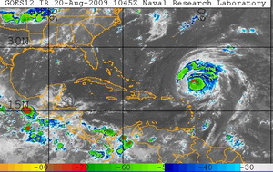
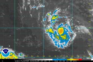
Hurricane Bill on Thursday morning is seen as it nears the United States.
Wind shear helped to slow Hurricane Bill’s wind speeds to Category 3 levels of 125 mph over the last 24 hours. However, the National Hurricane Center cautions that some strengthening is expected in the next 24 hours and Bill may return to Category 4 levels.
The storm now has hurricane force winds extended out 85 miles from its center and tropical storm winds extending out 230 miles. Moving toward the northwest at 18 mph, the effects of the season’s first major Atlantic hurricane will begin to be felt in the next 72 hours.
The Bahamas and Bermuda will begin to experience large swells in the next 24 to 48 hours. Portions of the United States east coast will also feel similar effects Friday into Saturday. The National Hurricane Center is cautioning residents of these areas that ocean waters will be “extremely dangerous” with “life-threatening rip currents.”
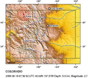
The latest quake was recorded at 1:58am and was centered 3.1 miles below the surface, much like the previous one in the Craig area. While the temblor was small enough that it most likely wasn’t felt, the recent quakes have garnered the attention of seismologists and geologists in the state.
Earthquakes in Colorado are not unusual as the USGS says nine were recorded this year and more than 100 in the last four years. However having this many in such a short time span is not particularly common. The last time the state experienced two quakes of magnitude 3.5 or greater so frequently was in 2001 when an earthquake “swarm” shook the area near Trinidad. During that event, from August 28 and September 21 of that year, 12 earthquakes of magnitude 2.8 to 4.6 struck just west of the southern Colorado city.
In a bit of a rarity for the Centennial State, Colorado experienced a 3.9 magnitude earthquake Sunday evening. According to the U.S. Geological Survey, the quake was centered nine miles east of Eads or 26 miles north of Lamar in the southeastern part of the state.
No damage was reported but the temblor was felt into western Kansas. Mary Breslin of Eads told the Denver Post she felt the shaking. “I really thought it was an explosion,” Breslin said. “It did not occur to me in the beginning that it was an earthquake.”
Originating at a depth of 6.2 miles, the quake occurred at 6:22pm along what state geologist Vince Matthews told the Associated Press might be part of a previously unmapped extension of the Cheraw Fault. See below for complete technical details on the quake.
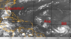
Tropical Storms Ana and Bill formed Saturday. The National Hurricane Center expects a tropical depression off of the coast of Florida to become Tropical Storm Claudette on Sunday.
Following on the first two named storms of the 2009 Atlantic hurricane season forming Saturday, a third may form off the coast of Florida today. Tropical Storm Ana, the first of the season, formed early Saturday. This was followed by Bill later in the day. Today the National Hurricane Center is forecasting that a tropical depression near Florida will reach tropical storm strength by the end of the day and if so, will be assigned the name Claudette.
Tropical Depression Four is currently 90 miles west-southwest of Tampa, Florida and moving to the north-northwest at 16 mph. With maximum sustained winds of 35 mph, the storm is just below the 39 mph threshold to become a tropical storm.
Strengthening is expected and the NHC predicts the system will become a tropical storm before it hits the coast. In anticipation of this, a tropical storm warning has been issued from the Alabama / Florida border east to the Suwannee River in Florida. Rainfall accumulations from 3 to 5 inches are expected with coastal storm surge of 3 to 5 feet.
Tropical Storm Ana has formed in the Atlantic and become the first named storm in that basin of the 2009 season.
The 2009 hurricane season began on June 1st but it wasn’t until this week that the Atlantic basin finally started to really show signs of life. Tropical Storm Ana has formed over the eastern Atlantic becoming that ocean basin’s first named storm of the 2009 season. By contrast, the Pacific basin has had nine storms with Hurricane Guillermo currently being the latest.
The National Hurricane Center says that Tropical Storm Ana is currently 1,010 miles east of the Leeward Islands where a Tropical Storm Watch may be issued later today. The storm is moving west at 16 mph with maximum sustained winds of 40 mph. The NHC says that Ana is expected to strengthen and pick up speed over the next 48 hours.
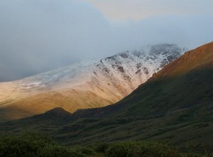
Denver has record setting cool temperatures and snow arrives in the Rocky Mountains. Image courtesy Victor Lewis.
While some parts of the nation experience record setting heat, on Thursday Denver had the opposite problem. The high temperature as measured at Denver International Airport reached a mere 64 degrees. This was two degrees below the previous record low maximum temperature of 66 degrees for this date set in 1925 and previous years. That is also an amazing 24 degrees below the normal temperature for this time of year!
Here in Thornton, we were even cooler than the official temperature on Thursday as the mercury climbed to a mere 61.3 degrees!
The unseasonably cold weather has also brought an unusual sight to the Colorado mountains in July – snow! Some northern parts of the Rocky Mountains in the state above 12,000 feet received a couple inches of snow.
Weather, natural disasters & climate news and information.


 For all the details on what these two esteemed meteorologists had to say, read the full storm on Examiner.com.