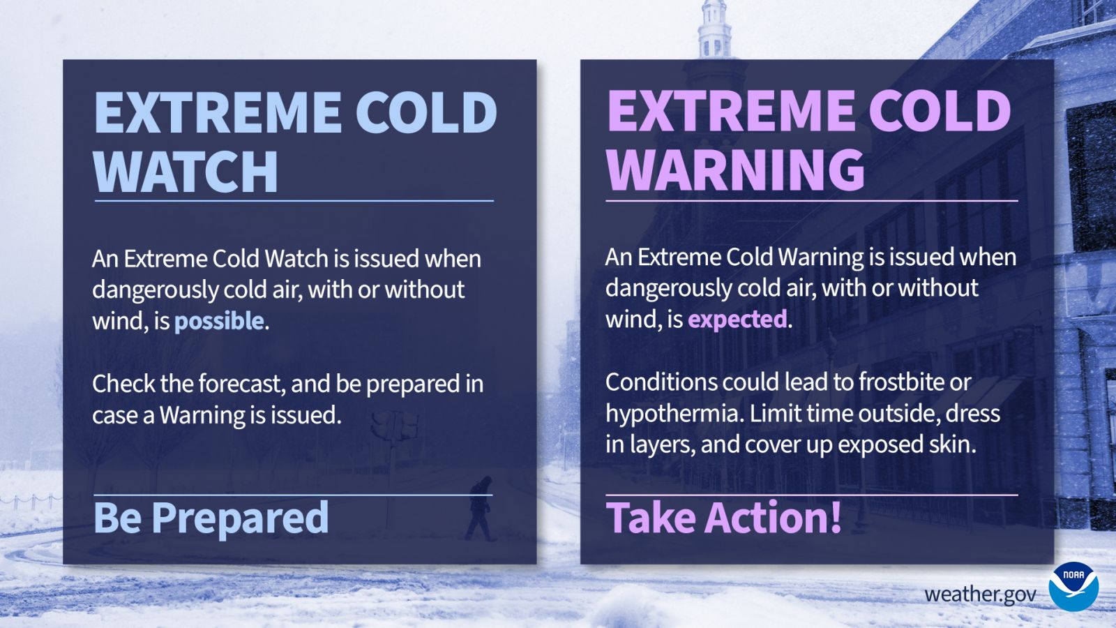
All posts by Thornton Weather

ThorntonWeather.com is your local source for live Thornton, Colorado weather conditions and news!

July 2024 top shots: Monthly photo slideshow

Thunderstorms move in on the evening of July 20, 2024. (David Canfield)

Colorado offers outdoor opportunities unlike any other state and while the summer heat settles in, photos of the amazing scenes across our state provide a view into why we love it here so much.

The weather this time of year has a pretty standard pattern of quickly warming temperatures followed by afternoon thunderstorms that can cool things down.  These storms sometimes provide a good bit of ‘excitement’ and are a prime photo subject.

  • Slideshow updated July 31, 2024

Recreationalists head outdoors and take advantage of urban, suburban and rural opportunities.  As they do, our abundant wildlife that is found just about anywhere comes into focus.

Showcasing images captured by ThorntonWeather.com readers as well as some of our own, our monthly slideshow covers the entire gamut of weather and nature related imagery.   Sunsets, sunrises, wildlife and of course every type of weather condition are vividly depicted.

To learn more about how to send your photo to us for inclusion in the slideshow, see below the slideshow.


What is missing in the slideshow above?  Your photo!

Our monthly photo slideshow is going to feature images that we have taken but more importantly images that you have captured.  The photos can be of anything even remotely weather-related.

Landscapes, current conditions, wildlife, pets, kids.  Whimsical, newsy, artsy.  Taken at the zoo, some other area attraction, a local park, a national park or your backyard.  You name it, we want to see and share it!

Images can be taken in Thornton, Denver or anywhere across the extraordinary Centennial State.  We’ll even take some from out of state if we can tie it to Colorado somehow.

We’ll keep the criteria very open to interpretation with just about any image eligible to be shown in our slideshows.

What do you win for having your image in our slideshow?  We are just a ‘mom and pop’ outfit and make no money from our site so we really don’t have the means to provide prizes.  However you will have our undying gratitude and the satisfaction that your images are shared on the most popular website in Thornton.

To share you images with us and get them included in the slideshow just email them to us or share them with ThorntonWeather.com on any of the various social media outlets.  Links are provided below.

So come on, get those camera’s rolling!

July 28 to August 3: This Week in Denver Weather History

This Week in Denver Weather History

Monsoonal moisture oftentimes streams into Colorado this time of year leading heavy rain and dangerous lightning. Our look back at this week in Denver weather history features many flooding events caused by the moisture and even some tornadoes.

From the National Weather Service:

13-5

In 2008…a streak of 24 consecutive days of 90 degrees shattered the previous record of 18 consecutive days established in 1901 and 1874. Ironically…no new single day record high temperatures were set in the month of July. In August however…a record of 104 degrees was set on the 1st…and another record of 103 degrees was set on the 2nd. In addition…a record low min of 70 degrees was set on August 2nd.

18-2

In 1987…a streak of 16 consecutive days of 90 degrees ranked 4th on the list of hot streaks. The record of 24 consecutive days was established in the summer of 2008.

27-31

In 1956…96 percent of the total precipitation for the month of July occurred over the last five days of the month. Heavy thunderstorms produced 4.00 inches of rainfall at Stapleton Airport. This amount of precipitation in 5 days or less had been exceeded only 3 times in previous record. The last time had been in December of 1913 as snow. Considerable property damage occurred across metro Denver from flooding.

28

In 1882…intense thunderstorm lightning struck a number of places in the city…but no significant damage was reported.

In 1910…heavy thunderstorm rainfall totaled 2.21 inches in downtown Denver. Rainfall was 1.11 inches in an hour during the early afternoon.

In 1922…heavy rainfall to the south of Denver caused Cherry Creek to rise to the top of the retaining walls in the city. The creek did not flood; however…the large volume of water discharged into the South Platte River did inundate a few blocks of Globeville. Flooding also occurred along bayou creek near Franktown to the south of the city.

In 1923…thunderstorm winds were sustained to 38 mph with gusts to 52 mph.

In 1957…iridescent cirrocumulus clouds of unusual formation and brilliant color…oriented from southwest to northeast over metro Denver…were sighted by U.S. Weather Bureau observers at Stapleton Airport shortly after noon.

In 1966…heavy rains from a severe thunderstorm caused flash flooding on Deer Creek…southwest of Littleton. A child was injured when washed from a car caught in the flood waters. The flooding damaged property along the creek. Strong winds damaged several houses in suburban Littleton.

In 1970…a microburst wind gust to 52 mph was recorded at Stapleton International Airport.

In 1974…a tornado was sighted just east of Buckley Field in Aurora. No damage was reported.

In 1982…up to 2.50 inches of rain drenched an area just southwest of Denver in 30 minutes. This was the second day of heavy rain across portions of metro Denver.

In 1984…1.25 inches of rain fell in 45 minutes in Arvada. Minor flooding occurred on bear creek after a small dam broke.

In 1989…lightning killed two men in Arvada. They were taking wash from a clothesline when a bolt hit the older man…39… Killing him instantly. The bolt then traveled along the line…which was stretched between 2 tall trees…and hit his 26-year-old brother who died the next day.

In 1996…several weak tornadoes developed along a thunderstorm outflow boundary that moved into southern weld…northern Jefferson…and Adams counties. The tornadoes sighted near Bennett…Barr Lake…and in Arvada caused little damage. Strong thunderstorm winds downed several trees in the city of Denver and toppled several trees 7 miles west of Arvada where shingles were blown off several houses. Thunderstorm wind gusts reached 58 mph in Broomfield.

In 1997…a weak tornado touched down briefly in Parker… Damaging a greenhouse. Twenty pieces of the fiberglass roof were ripped away. Heavy rainfall in the foothills washed out some culverts in the Pine and Conifer areas. Heavy rainfall spread over the plains with 4 to 7 inches reportedly falling near Hudson. Several county roads were washed out between Fort Lupton and Hudson. Several basements in the area were flooded up to the ceiling. Standing water…up to 3 feet deep…was reported in some backyards. Later in the evening…a flash flood killed 5 people and injured 40 others in two mobile home parks in Fort Collins. The torrential rainfall also caused extensive damage on the Colorado state university campus. Thunderstorm rainfall totaled 0.80 inch at Denver International Airport and 1.09 inches at the site of the former Stapleton International Airport.

In 1999…heavy rainfall…up to 3 inches an hour…triggered a massive rock and mudslide along I-70 near Bakerville. The slide area was about 200 feet wide and 20 feet deep. Several other smaller slides were also reported along the highway. As a result…I-70 was closed for nearly 25 hours in both directions until the debris could be cleared from the roadway. The blockage of I-70 was one of the longest in the history of the highway in Colorado. A severe thunderstorm produced a wind gust to 64 mph at Denver International Airport. The storm also produced 1.56 inches of rain and briefly reduced the visibility to 1/4 mile.

In 2004…a severe thunderstorm produced hail as large as 1 inch in diameter in Thornton.

In 2010…a wet microburst produced very heavy rain and torrential hail in Boulder County…in the vicinities of caribou…Nederland and Eldora. Flash flooding washed out sections of County roads 126 and 128 near caribou. Several large Boulders had fallen across the roadways. Considerable flooding was reported in Nederland. Water was also observed running across County Road 130…between Eldora and Nederland. The hail had accumulated up to 8 inches deep near Eldora. Several vehicles were stuck in the ice…forcing the temporary closure of CR130 and the Lake Eldora Ski Road until snowplows could clear away the hail. Lightning strikes caused minor damage to two local businesses in Nederland. At Denver International Airport…a thunderstorm produced 0.30 inches of rain along with a peak wind gust to 38 mph.

In 2012…a tornado touched down briefly at the southeast corner of Mt. Evans near Lincoln Lake. The estimated elevation where this tornado touched down was near 12500 feet. This would make this tornado one of the highest ever observed in the U.S.

In 2014…two weak landspouts touched down; one near Ft. Lupton and the other on the southwest side of the Rocky Mountain Arsenal Wildlife Refuge. No damage was reported. A strong thunderstorm wind capsized a boat in Barr Lake. All three occupants made it to shore with no injuries.

In 2016…severe thunderstorms in western Adams and east central Jefferson Counties produced large hail near Lakewood…Golden and South Glenn. The hail ranged from 1 to 1 1/2 inches in diameter.

28-30

In 1889…dense smoke from forest fires in the mountains obscured the sun over the city for three days.

In 1971…a vigorous cold front late on the 28th produced northeast wind gusts to 39 mph and record breaking cold temperatures on the 29th and 30th. The temperature dipped to 47 degrees on the 29th and 43 degrees on the 30th… Setting record minimums for the dates. Upslope cloudiness along with rain and fog early on the 29th helped set a record low maximum temperature of 58 degrees for the date.

29

In 1878…a total eclipse of the sun was observed at 2:20 pm. From before to during the eclipse…the temperature in the sun fell from 114 degrees to 82 degrees…while the shade temperature fell from 89 degrees to 83 degrees.

In 1880…heavy thunderstorm rain and hail flooded streets and ditches.

In 25 minutes…0.76 inch of rain fell on the city along with large hail to 3/4 inch in diameter. There were no strong winds with the storm.

In 1890…a thunderstorm produced sustained west winds to 48 mph with gusts to 60 mph…but only 0.01 inch of rain.

In 1956…heavy rain and hail fell over west and north Denver.

In 1964…hail to 3/4 inch in diameter fell at Lowry Airfield.

In 1978…a small tornado was sighted just east of Parker. No damage was reported.

In 1989…heavy rain drenched all areas of the Front Range… Both in the foothills and adjacent plains. Amounts of 1 to 3 inches were general over the area. Damage was confined to a few minor road washouts and some street…basement…and crop flooding. Thunderstorm rainfall totaled 1.44 inches at Stapleton International Airport where north winds gusted to 43 mph. Lightning struck a 250 thousand dollar home near Nederland and started a fire which destroyed all of it except two garages. Lightning started a fire in a home in Evergreen. It reached the house by hitting a tree…then traveling through a metal clothesline strung between the tree and the building.

In 1995…thunderstorm winds gusted to 59 mph in Brighton. Thunderstorm winds from the south-southeast gusted to 41 mph at Denver International Airport. High temperature of 99 degrees was a new record maximum for the date in Denver.

In 1997…heavy rain caused flooding in an apartment building in Westminster. Several residents had to be evacuated from their apartments. A woman in Aspen Park received minor injuries…when lightning passed through an office window and struck her. She suffered temporary blindness for about 15 minutes.

In 2003…hail as large as 1 inch in diameter pelted Conifer… Highlands Ranch…and Franktown.

29-30

In 1997…heavy rain caused flooding and flash flooding in central portions of Adams and Arapahoe counties. Two homes were extensively damaged when water flooded the basements and adjacent pasture area in Strasburg. Water 4 to 5 feet deep had pooled in the lower lying areas of the town. A portion of quincy road was closed in Arapahoe County when 4 feet of water covered the roadway. Rainfall totaled 3.06 inches at Denver International Airport…establishing a new record for 24-hour rainfall in July. The previous record was 2.42 inches set in 1965 on the 24th and 25th.

Continue reading July 28 to August 3: This Week in Denver Weather History

July 21 to July 27: This Week in Denver Weather History

This Week in Denver Weather History

As we continue in what is the hottest time of the year, we also begin to enter the monsoon season. Our look back at this week in Denver weather history shows that this can bring a wide range of severe weather. Most common are heavy rains which can lead to flooding but dangerous and damaging lightning and hail and even tornadoes are possible.

From the National Weather Service:

7-25

In 1934…a streak of 15 consecutive days of 90 degrees ranked 5th on the list of hot streaks. The record of 24 consecutive days was established in the summer of 2008.

13-5

In 2008…a streak of 24 consecutive days of 90 degrees shattered the previous record of 18 consecutive days established in 1901 and 1874. Ironically…no new single day record high temperatures were set in the month of July. In August however…a record of 104 degrees was set on the 1st…and another record of 103 degrees was set on the 2nd. In addition…a record low min of 70 degrees was set on August 2nd.

18-2

In 1987…a streak of 16 consecutive days of 90 degrees ranked 4th on the list of hot streaks. The record of 24 consecutive days was established in the summer of 2008.

19-23

In 2005…the high temperature climbed above 100 degrees on each of the 5 days with readings of 101 on the 19th…105 on the 20th…104 on the 21st…and 102 on both the 22nd and 23rd. A new record maximum temperature for the month of July of 105 degrees was set on the 20th…which also equaled the all-time record maximum for Denver of 105 degrees first set on August 8th in 1878. Daily maximum temperature records were set on each day…and the 5 day period equaled the record for the most consecutive days of 100 degrees or more first set from July 4th through 8th in 1989. The intense heat resulted in a high use of electricity for cooling purposes. The demand for electric power exceeded the supply and rolling black-outs… Each lasting about an hour…were scheduled across metro Denver during the afternoons and early evenings.

20-23

In 1961…unusually cool weather for July resulted in several temperature records. Record minimum temperatures were set or equaled on each day with readings of 51…51…49… And 49 degrees. High temperature of only 64 degrees on the 21st was a record low maximum for the date.

20-25

In 1965…heavy showers and thunderstorms doused metro Denver with significant rain each day. Rainfall for the six days totaled 5.16 inches at Stapleton International Airport. Massive rainfall occurred on the 20th…21st…and 25th… Flooding streets and basements and causing streams to overflow. The heaviest rainfall…2.05 inches…at Stapleton International Airport occurred on the 25th.

21

In 1879…lightning struck a house in north Denver. The bolt struck the center of the roof driving part of it into the house and scattered shingles all over the yard. Furniture in the house was heavily damaged…but none of the nine residents were injured other than being stunned. The noise sounded as if a cannon had been exploded. Rainfall was only 0.02 inch downtown.

In 1921…northwest winds were sustained to 42 mph with gusts to 48 mph.

In 1943…a severe thunderstorm during the evening caused the death of a man whose truck skidded on a muddy roadway on a steep hill and overturned pinning him underneath. Several small fires were started by the lightning…and electrical wires were downed. No serious property damage was reported… But firemen answered 19 alarms in 2 hours. One person was injured by lightning.

In 1965…a funnel cloud was sighted in the northern portion of Denver. Later…4 or 5 funnel clouds were sighted about 15 miles north of Stapleton International Airport. Heavy rain accompanied by hail washed away part of a city street and caused other flooding in central city. There were heavy showers and some damage from lightning in both Denver and Boulder. Marble to golf ball size hail fell 10 miles northwest of Stapleton Airport.

In 1966…heavy thunderstorm rains flooded streets and basements across metro Denver.

In 1973…a tornado touched down briefly 2 miles northeast of Parker…causing minor damage. Funnel clouds were also sighted 3 miles northeast of Sedalia…11 miles south southeast of Stapleton International Airport…and near Parker. Hail to 3/4 inch in diameter fell over the western suburbs of Denver.

In 1974…heavy thunderstorm rains caused flash flooding in metro Denver. Rainfall totaled 1.26 inches at Stapleton International Airport.

In 1976…heavy thunderstorm rains occurred across south metro Denver with 1.75 inches of rain recorded in 40 minutes in southeast Aurora and 2.00 inches in 20 minutes at Cheery Creek Reservoir. A funnel cloud was sighted by the public east of Arapahoe County airport…now Centennial Airport.

In 1981…the temperature reached 100 degrees…setting a new record high for the date.

In 1983…downpours drenched the Front Range where amounts of 1 to 2 inches were common. The heaviest reported rainfall was 2.36 inches in a 6-hour period at Parker where hail to 3/4 inch and wind gusts as high as 75 mph occurred. Up to golf ball size hail fell in the Parker and Castle Rock areas; wind gusts to 75 mph were recorded in Castle Rock.

In 1993…thunderstorm winds toppled a 3 story high Russian olive tree in Boulder. The tree barely hit and only slightly damaged a parked car.

In 1995…thunderstorm winds from the west gusted to 55 mph at Denver International Airport.

In 2002…heavy thunderstorm rainfall caused flash flooding in the Hayman fire burn area. South Deckers Road…State Highway 126…was closed when 4 feet of water inundated a section of the roadway. The U.S. Forest Service had to remove 40 truckloads of sediment to reopen the road. Also…heavy debris flow washed out a secondary service road in southwest Douglas County. Hail as large as 3/4 inch in diameter fell near Bennett.

In 2011…lightning struck a home in Arapahoe County and caused substantial fire damage. Five people were in the home but no one was injured. There was structural damage to both the interior and exterior of the residence.

22 Continue reading July 21 to July 27: This Week in Denver Weather History

Thornton Weather’s weather station is nearing its end of life

The time is coming… Our Davis Instruments VP2+ weather station has served us well for 17+ years. Sadly, despite many parts replacements, it is showing its age and we are going to need to get a new unit soon.

As this is a professional-level weather station to ensure accuracy and reliability, you can imagine it is not cheap. Normally we would not ask this but, in the past, our supporters’ donations have helped us maintain and upgrade the station and we are hoping you might consider helping us keep Thornton’s longest running, most reliable weather station going.

To learn more, please see here.

July 14 to July 20: This Week in Denver Weather History

This Week in Denver Weather History

Monsoonal rain, dangerous lightning and large hail are all par for the course as we see in our look back at this week in Denver weather history. But, what about snow? Yes, you read that right. Denver did actually record snowfall on July 17, 1872 but because it occurred before official snowfall measurements began in the young Mile High City, it doesn’t count. See below for complete details.

From the National Weather Service:

1-18

In 1874…a streak of 18 consecutive days of 90 degrees tied for second with another streak that was later set in the summer of 1901. The record of 24 consecutive days was established in the summer of 2008.
1-31

In 2012…it was the hottest July on record in Denver since weather records began in 1872. The average temperature for the month was 78.9 degrees which was 4.7 degrees above normal. There were 27 days in which the high temperature equaled or exceeded 90 degrees…which established a new record. There were also 7 days in which the temperature equaled or exceeded 100 degrees which tied the record set in 2005.

6-23

In 1901…a streak of 18 consecutive days of 90 degrees tied for second with another streak set in the summer of 1874. The record of 24 consecutive days was established in the summer of 2008.

7-25

In 1934…a streak of 15 consecutive days of 90 degrees ranked 5th on the list of hot streaks. The record of 24 consecutive days was established in the summer of 2008.

13-5

In 2008…a streak of 24 consecutive days of 90 degrees shattered the previous record of 18 consecutive days established in 1901 and 1874. Ironically…no new single day record high temperatures were set in the month of July. In August however…a record of 104 degrees was set on the 1st…and another record of 103 degrees was set on the 2nd. In addition…a record low min of 70 degrees was set on August 2nd.

14

In 1878…the temperature reached a high of 100 degrees in downtown Denver.

In 1906…a thunderstorm produced north winds sustained to 52 mph and 0.53 inch of rain in 10 minutes.

In 1912…a heavy thunderstorm cloudburst in the late afternoon combined with a similar storm to the south of the city to produce widespread flooding on Cherry Creek in downtown Denver…which resulted in two deaths and several injuries. The flooding was the worst since 1864 and covered around 3 square miles of lower downtown. Bridges along Cherry Creek were washed out and water lapped at the floor of the Broadway bridge over the South Platte River…causing authorities to declare it unsafe except for pedestrians. By nightfall… Union Depot was under 2 to 3 feet of water…and railroad and street car traffic was stalled. Those forced from their homes by the surging flood waters took refuge in the Denver auditorium. The flood waters caused great damage to the sewerage system…parkways…bridges and residences and commercial warehouses near Cherry Creek in the wholesale district. Flood damage was estimated at several million dollars. Heavy thunderstorm rainfall of 2.00 inches…of which nearly 1.75 inch fell in 30 minutes in central Denver… Was accompanied by severe thunderstorm winds sustained to 55 mph with gusts as high as 74 mph.

In 1933…thunderstorm rainfall was only 0.01 inch…but northwest winds sustained to 37 mph with gusts to 47 mph produced a dust storm for about 10 minutes during the late afternoon.

In 1967…heavy rain flooded areas of north and west metro Denver…and high water closed street intersections in the city. Crops were damaged…and 200 chickens drowned by flooding northwest of Denver where farm buildings and irrigation facilities were also damaged.

In 1969…a thunderstorm wind gust to 51 mph was recorded at Stapleton International Airport.

In 1975…heavy rains caused locally heavy flash flooding along Niver Creek south of Thornton and in other parts of north metro Denver. Over 40 thousand dollars in damage to public property was reported…and numerous homes and yards were damaged.

In 1986…thunderstorm winds blew down a power line in west- central Jefferson County. The storm…as it moved into Denver…snapped tree limbs and damaged a fence near Washington Park. Wind gusts in the area were estimated at 80 to 85 mph.

In 1990…thunderstorm wind gusts to 58 mph were recorded at Buckley Field in Aurora. No damage was reported. Winds gusted to 44 mph at Stapleton International Airport.

In 1993…a severe thunderstorm moved across southern sections of metro Denver. Dime size hail fell in Lakewood…and hail up to one inch diameter was measured at Cherry Creek Reservoir. Later in the afternoon…hail to one inch diameter fell in Golden and Arvada.

In 1994…hail to 1 1/4 inches in diameter fell north of Bennett.

In 1998…dry microburst winds estimated to 70 mph snapped tree branches up to 4 inches in diameter in Brighton where some road signs were twisted and blown down. At Denver International Airport…dry microburst winds gusted to 61 mph.

In 1995…thunderstorm winds gusted to 62 mph near Strasburg.

In 2001…a severe thunderstorm dumped hail to 3/4 inch in diameter in the foothills about 10 miles northwest of Golden.

In 2011…severe thunderstorms in the Denver metropolitan area produced very heavy rain…large hail and damaging winds. The strong winds toppled a few trees and the heavy rain caused street flooding and minor flash flooding. Several cars were stranded at the intersection of Santa Fe Drive and Oxford…and near Broadway and U.S. Highway 285. A 16-yr old teenager was seriously injured when he tried to retrieve a ball along the banks of west toll gate creek. He was pulled from the swollen creek and died several days later. Hail up to one inch in diameter was reported around the area. The thunderstorms also produced frequent lightning. One strike sparked a fire at aspen academy…a private school in greenwood village. Most of the damage was confined to the roof and attic. In Englewood…a 40-ft tree was blown into a house and knocked down some power lines. At Denver International Airport…a severe thunderstorm produced sustained winds of 47 mph and a peak wind gust to 68 mph.

In 2019…a Denver man was killed and his wife injured after he was struck by lightning when they were hiking near the Bear Peak West Ridge Trail. The man was likely hit from a direct lightning strike to his upper body. His wife was not directly hit…but injured by the electrical current from the strike that hit her husband.

14-15

In 1985…thunderstorms dumped heavy rain and hail at numerous locations along the Front Range from Denver north. Some of the heaviest rain fell in northern and western suburbs of Denver. Up to 2.6 inches of rain drenched Arvada…and Thornton was soaked with 2 inches in 45 minutes. At least 5 homes in Arvada suffered extensive damage from water and mud…and many streets and basements were flooded.

In southern Jefferson County…11 homes were struck by lightning.

15

In 1879…a terrific hail storm occurred in the vicinity of Buffalo Station on the South Park Railroad in the South Platte River Canyon about 39 miles south of Denver. Stones as large as hen’s eggs fell thick and fast and broke nearly every pane of glass in the windows of the building. A “waterspout” or cloudburst caused much loss of property from flash flooding on a nearby gulch. The torrent of water caused a deafening roar as it uprooted trees and carried huge Boulders and other debris. It struck the house and sawmill simultaneously and carried them away like straws…leaving little behind. The water continued to rush down the gulch for several hours. Serious damage was done to the south park railroad. The track and roadbed were destroyed for several miles. At about the same time…heavy rains in the vicinity of the headwaters of Cherry Creek produced a rapid rise in the creek…which drowned a few head of cattle and washed away two footbridges and some fences. Only 0.10 inch of rainfall was recorded in Denver.

In 1896…a thunderstorm produced sustained southwest winds to 40 mph with gusts to 46 mph.

In 1902…the temperature reached a high of 100 degrees in downtown Denver…which was a record maximum for the date.

In 1929…a thunderstorm did considerable damage to property in the eastern portion of the city. Heavy hail ranging in size from 1/4 to 3/4 inch in diameter…severe lightning… And high winds accompanied the heavy rain. Basements were flooded…and streets were impassable in places for several hours due to the heavy rainfall. Lightning damaged several telephone poles. Hail did extensive damage to gardens and flowers. The hail was up to a foot deep in places. There was no estimate of damage from the storm. A thunderstorm produced only a trace of rain and east winds to 24 mph in downtown Denver.

In 1959…thunderstorm rain totaled 0.41 inch in 8 minutes and winds gusted to an estimated 50 mph near downtown Aurora where half inch diameter hail was also reported. After the storm moved to the east…complete double rainbows were observed from the weather bureau office at Stapleton Airport.

In 1962…hail pelted the area in Adams County around Henderson and Brighton…causing extensive damage to corn…grain… Beets…and row crops. Crop damage was estimated at 250 thousand dollars.

In 1963…a man received severe burns when struck by lightning while painting a building in south Denver.

In 1965…a state patrolman sighted a tornado near Bennett. It touched down over open ground…but caused no damage.

In 1967…heavy rains flooded streets and underpasses in south Denver. Heavy rain and minor wind damage were reported in Wheat Ridge…Aurora…Englewood…and Littleton. Basements were flooded and power disrupted. The clouds and rain resulted in a high temperature of only 72 degrees…which was a record low maximum for the date.

In 1974…a severe lightning storm damaged several homes and caused a number of power outages in both Denver and western Arapahoe counties.

In 1975…lightning killed a girl west of Boulder.

In 1982…winds gusted to 60 mph at Stapleton International Airport…and strong winds blew down walls at a construction site in Aurora where a nearby tree was uprooted.

In 1985…0.79 inch of rain fell in 30 minutes at Castle Rock. Much of the town lost power when lightning struck the town’s transformer.

In 1992…a man was struck by lightning while horseback riding near Castle Rock. Two people were struck by lightning near Highlands Ranch in south metro Denver. A man was struck by lightning while riding in the back of a pick-up truck in Franktown. All received minor injuries. Strong thunderstorms moved through east metro Denver…producing large hail and flash flooding. Hail up to 1 1/4 inches in diameter fell near Buckley Air National Guard base. Rainfall of 1 to 3 inches fell in Aurora in less than an hour…leaving water up to 18 inches deep in some areas. Thunderstorm rainfall was measured at 0.97 inch at Stapleton International Airport…where 3/8th inch diameter hail fell and south winds gusted to 44 mph.

In 1993…dime size hail fell in Golden. National weather service observers at Stapleton International Airport sighted a small rope-like funnel overhead for about 3 minutes before it dissipated.

In 1994…a small…short-lived tornado caused damage to a house under construction in Parker.

In 1995…thunderstorm winds of unknown strength downed trees and branches…damaging a porch and nearby cars in Denver.

In 1998…hail to 7/8 inch in diameter fell near Keenesburg.

In 2000…this date marked the end of a near record hot streak for metro Denver. The high temperature at Denver International Airport equaled or exceeded the 90-degree mark for 17 consecutive days…from June 29th. This was one day short of equaling the all-time record. The record of 18 consecutive days was set in two different years…July 1st-18th…1874 and July 6th-23rd…1901.

In 2005…severe thunderstorms produced large hail over southeast metro Denver. Hail as large as 1.75 inches in diameter fell in southwest Aurora along with 7/8 inch hail in Centennial. Hail to 3/4 inch in diameter was measured near Centennial Airport and near Watkins.

In 2015…A severe thunderstorm produced a peak wind gust to 60 mph from the northwest at Denver International Airport. In addition…0.06 inches of rainfall was also observed.

In 2016…large hail ranging in size from 1 to 2 inches in diameter struck Aurora…Castle Rock…Centennial…Greenwood Village and southeast Denver. The hail shattered windshields and caused extensive damage to vehicles.

15-16 Continue reading July 14 to July 20: This Week in Denver Weather History