All posts by Thornton Weather

ThorntonWeather.com is your local source for live Thornton, Colorado weather conditions and news!

March 24 to March 30: This Week in Denver Weather History

This Week In Denver Weather History
March 24 to March 30: This Week in Denver Weather History

As we have witnessed in recent days, significant snow events can make an appearance in Denver during the month of March and there have been a number of them in our past. Also not unusual and appearing are powerful, damaging winds. These types of events as well as thunderstorms, hail and even a tornado have occurred during this week in Denver weather history.

From the National Weather Service:

22-24

In 1965…a vigorous cold front swept across metro Denver late on the afternoon of the 22nd with east-northeast winds gusting to 38 mph causing some blowing dust. Snowfall from the storm totaled 4.4 inches at Stapleton International Airport. Temperatures on the 22nd dropped from a maximum of 63 degrees to 18 degrees in just 10 hours and dipped to 3 degrees below zero on the morning of the 24th. Maximum temperatures warmed to only 19 degrees on the 23rd and 18 degrees on the 24th.

23-24

In 1909…post-frontal rain on the 23rd changed to heavy snow during the evening and continued through the morning of the 24th. Snowfall totaled 13.8 inches. Rain and melted snow… Totaled 2.43 inches…which was the record greatest 24 hour precipitation ever recorded in March at that time. A thunderstorm of moderate intensity occurred on the 23rd in advance of the cold front. North winds were sustained to 27 mph overnight.

In 1990…several hours of freezing drizzle covered roadways with a thin layer of “black ice” which caused nearly 100 traffic accidents across metro Denver. In Boulder…snow and freezing rain caused numerous accidents and brief power outages. Snow in Boulder ranged from an inch east of town to 4 to 5 inches near Table Mesa. At times thunder was heard during the snow. Snowfall totaled only 0.6 inch at Stapleton International Airport where northwest winds gusted to 30 mph on the 23rd.

In 1995…high winds developed late on the 23rd and continued through the 24th. A few windows were blown out of a Denver high rise building…spraying glass on the sidewalks and streets below. Southeast winds gusted to 48 mph at Denver International Airport on the 23rd.

In 1996…the third storm in 10 days brought heavy snow to the mountains…foothills…and metro Denver. Snowfall totaled 18 inches at Golden Gate Canyon and 10 inches at Nederland in the foothills. Across metro Denver… Snowfall ranged from 4 to 8 inches. At the site of the former Stapleton International Airport…snowfall totaled 6.5 inches with most of the snow occurring on the 24th. North winds gusted to 34 mph at Denver International Airport. As the storm moved east on the 24th and 25th… Blizzard conditions developed over northeastern Colorado closing both I-70 and I-76 east of Denver.

In 2010…a powerful spring snowstorm swept across northern Colorado. The heaviest snowfall occurred in and near the Front Range foothills and deep upslope developed. The heavy…wet snow clung to tree limbs and power lines…which caused 36500 electrical outages throughout Denver and the surrounding metro area. Power outages also occurred in Douglas and Elbert counties. In addition…approximately 5 thousand travelers were stranded at Denver International Airport due to flight cancellations and delays. Initially… The snow fell at a rate of 2 to 4 inches per hour…between Boulder and Denver…bringing the evening rush hour to a complete halt. Countless motorists were stuck on U.S. Highway 36 for several hours. Other road closures included I-70…from Idaho Springs to Genesee and I-25 in both directions…from Lincoln Avenue south to Greenland… Or about 15 miles south of Castle Rock. In and near the Front Range foothills and Palmer Ridge…storm totals included: 26 inches at Coal Creek Canyon…23.5 inches…3 miles south of Evergreen; 22 inches at Aspen Springs…13 miles northwest of Golden and 3 miles west of Jamestown; 21.5 inches…3 miles north of Blackhawk…20 inches at Genesee; 16 inches near Nederland; 14 inches near Elizabeth and Strontia Springs dam; 13 inches at Bergen Park and 3 miles southeast of Indian Hills; 12.5 inches… 3 miles southwest of Conifer; 11.5 inches at St. Mary’s Glacier. In Denver and the surrounding suburbs…storm totals included: 15 inches at lone tree; 14 inches near Highlands Ranch; 13 inches near Louisville…12.5 inches at Aurora…Commerce City…Englewood and 5 miles west of Littleton; 12 inches at Erie and Greenwood Village; 11 inches at Ralston Reservoir and Westminster; 10.5 inches at the national weather service in Boulder…10 inches… 4 miles northeast of Castle Rock…Fredrick…Lakewood…3 miles southeast of Morrison and 4 miles southeast of Watkins; 9.5 inches…3 miles southeast of Denver; 9 inches in Broomfield…Lafayette…Northglenn and Thornton; 8.5 inches near Federal Heights; 8 inches in Arvada… Brighton and Wheat Ridge; 6 inches…5 miles southwest of Hudson. Officially…10.8 inches of snow was measured at Denver International Airport.

23-25

In 1891…rain changed to snow and totaled 8.8 inches in downtown Denver. Most of the snow fell on the 24th. Winds were light.

In 1964…heavy snowfall of 5.8 inches was measured at Stapleton International Airport. North-northeast winds gusted to 21 mph behind a cold front.

Continue reading March 24 to March 30: This Week in Denver Weather History →
National Weather Service begins 2013 storm spotter training sessions

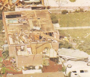
On June 3, 1981 a tornado struck Thornton in what is the worst twister to have struck the Denver metro area. Are you ready should disaster strike again? Image courtesy the City of Thornton archives.

Severe weather is a fact of life in Colorado – from blizzards to tornadoes we can and do see it all.  Each year the weather is responsible for claiming lives in our state and across the nation and the threat is very real.  Storm spotter training allows you to learn how to protect yourself and your family while providing a public service.

Education is key to knowing how to protect you and your family.  Whether you want to be an official storm spotter or maybe just want to learn more about severe weather, storm spotter training can provide you an incredible opportunity to learn.

The National Weather Service Denver / Boulder office has announced a series of Skywarn storm spotter training dates for Colorado for the 2013 season.

The storm spotter program is a nationwide program with more than 280,000 trained spotters.  These volunteers report weather hazards to their local National Weather Service office providing vital information when severe strikes.  Data from spotters include severe wind, rain, snow measurements, thunderstorms and hail and of course tornadoes.

Storm spotters are part of the ranks of citizens who form the Nation’s first line of defense against severe weather. There can be no finer reward than to know that their efforts have given communities the precious gift of time–seconds and minutes that can help save lives.

By completing one of these training classes you can become an official storm spotter.  When severe weather strikes, you can report it by calling a special toll free number or submit your report via the National Weather Service’s website.

These are great sessions for anyone wanting to learn more about the severe weather we experience in Colorado, whether you want to be an official spotter or not.  All training is free.  Topics include:

  • Basics of thunderstorm development
  • Fundamentals of storm structure
  • Identifying potential severe weather features
  • Information to report
  • How to report information
  • Basic severe weather safety

To learn more about the program, see here: http://www.crh.noaa.gov/bou/awebphp/spotter.php

Below are the dates, times and locations announced thus far with the first occurring on Sunday, February 17 and two scheduled in May in the north Denver metro area.  We will try to keep this updated but you can click here for any new dates on the National Weather Service website.

Schedule updated 3/28/13:

April, 2013 – Upcoming
Day City, State Time Location
04 Kiowa, CO
(Elbert County)
6:00pm MDT Elbert County Fairgrounds 75 Ute Ave – Kiowa, Co 80117
Contact Information: Cory.Stark@elbertcounty-co.gov
06 Fort Collins, CO
(Larimer County)
8:30am MDT ARES District 10 training Fort Collins Police Services Building, 2221 South Timberline Road, Fort Collins, CO 80525
Contact Information: k0jef@arrl.net
08 Fort Morgan, CO
(Morgan County)
6:30pm MDT American Legion Building, 16913 Morgan County Road 17.10 (Nelson Road) Fort Morgan Co.
Contact Information: senfante@co.morgan.co.us
11 Hugo, CO
(Lincoln County)
2:00pm MDT Lincoln County Courthouse 103 3rd Street, Hugo, CO 80821
Contact Information: lclanduse@lincolncountyco.us
11 Hugo, CO
(Lincoln County)
6:30pm MDT Lincoln County Courthouse 103 3rd Street, Hugo, CO 80821
Contact Information: lclanduse@lincolncountyco.us
15 Loveland, CO
(Larimer County)
9:00am MDT The Rialto Theater 228 E. Fourth Street Loveland, Colorado 80537
Contact Information: Pat.Mialy@cityofloveland.org
15 Fort Collins, CO
(Larimer County)
6:30pm MDT Fort Collins Police Services Building, Community Service Room 2221 S. Timberline Drive Fort Collins Colorado
Contact Information: migavin@poudre-fire.org
18 Highlands Ranch, CO
(Douglas County)
7:00pm MDT Douglas County ARES training Douglas CO Sheriff’s Office Highlands Ranch Substation 9250 Zotos Drive Highlands Ranch, CO 80126 Phone: 303-784-7880
Contact Information: randy.w0rdr@gmail.com
22 Greeley, CO
(Weld County)
7:00pm MDT Note: time change! 1150 O Street, Greeley 80632 (970) 356-4000 x 3997
Contact Information: gmarquez@co.weld.co.us
27 Evergreen, CO
(Jefferson County)
9:00am MDT Evergreen Fire Rescue Admin Building – Auditorium 1802 Bergen Parkway, Evergreen, CO
Contact Information: mswinden@evergreenfirerescue.com
29 Centennial, CO
(Arapahoe County)
6:30pm MDT Arapahoe Sheriff’s 13101 East Broncoes Parkway Centennial, CO 80112
Contact Information: AWallin@ArapahoeGov.com
30 Denver, CO
(Denver County)
6:30pm MDT Denver ARES training Denver’s COP Shop, 407 South Broadway, #500, Denver, CO
Contact Information: kc0mht@msn.com
May, 2013 – Upcoming
Day City, State Time Location
02 Parker, CO
(Douglas County)
6:30pm MDT Parker Police 18600 Lincoln Meadows Pkwy Parker, CO 80134?
Contact Information: khenry@parkeronline.org
04 Elbert, CO
(Elbert County)
9:00am MDT Elbert School 24489 Main Street Elbert, CO 80106
Contact Information: Cory.Stark@elbertcounty-co.gov
06 Westminister, CO
(Adams County)
3:30pm MDT Front Range Community College 3645 West 112th Avenue, Rocky Mountain Room (near entrance 2) Westminister, CO
Contact Information: rachel.humphrey@frontrange.edu
06 Westminister, CO
(Adams County)
7:00pm MDT Front Range Community College 3645 West 112th Avenue, Rocky Mountain Room (near entrance 2) Westminister, CO
Contact Information: rachel.humphrey@frontrange.edu
18 Commerce City, CO
(Adams County)
10:00am MDT Adams County Sheriff’s Office Sub-station, 2nd floor at 4201 east 72nd Ave Commence City.
Contact Information: r1@rampartsar.com

Video: Denver’s late March snowstorm as seen from Thornton

The snow is falling, the wind is blowing and it is cold and nasty out there right now.  We took to the street for a little bit to capture some video of our late spring snowstorm.  Highlights include the flag flapping in the wind, blowing snow, shoveling and even an appearance by Scout, our Frisbee catching dog who doesn’t mind the snow one bit.

Update, 4:45pm: Below the first video taken this morning is a second video captured from our east facing webcam.  It is a time lapse showing the past 24 hours compressed into 48 seconds.

Live updates: Follow along for the latest with Thornton’s early spring snowstorm

ThorntonWeather.com on Facebook, Google+ and TwitterIt may be the first weekend of spring but Old Man Winter isn’t ready to give up yet.  Another dose of wintry weather is said to deliver a good shot of snow and some pretty nasty, cold temperatures.  We will be monitoring monitoring the storm very closely and posting regularly to our Facebook page and Twitter feed.  You can follow along in real time below.  We are also on Google+ here.
For comprehensive look at the storm, please monitor our Winter Weather Briefing page.


First images from new Landsat satellite capture northern Colorado Front Range

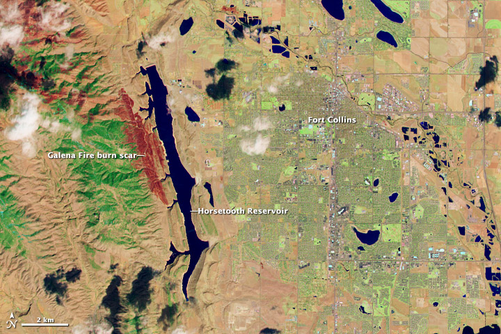
For four decades Landsat satellites have beamed back amazing pictures of the Earth from their perch far above the planet’s surface.  The latest craft in the series was launched last month and among the first images it captured were pictures of the area around Fort Collins and the Galena Fire burn scar.

The Landsat Data Continuity Mission took to space on February 11 to continue the joint program between NASA and the USGS.  This latest spacecraft has some of the highest resolution imagery devices of any Earth-observing satellite and will allow the agencies to monitor the natural and human processes taking place on the planet.

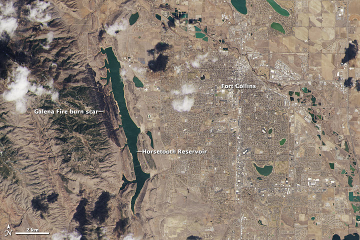
This week NASA released some of the first images from the new craft including its ‘Image of the Day’ from the Earth Observatory program on Thursday.  The photos capture the northern Colorado Front Range in natural color and one showing wavelengths of light not seen by the human eye.  The city of Fort Collins is clearly seen as is the Galena Fire burn scar west of Horsetooth Reservoir.

Below the images are further explanation from NASA.

landsat1.jpg
Made with reflected red, green, and blue light, the image from the Landsat Data Continuity Mission shows Fort Collins as the human eye would see it. (NASA)
landsat2.jpg
The image from the Landsat Data Continuity Mission shows the Fort Collins area in wavelengths of light not usually visible to people. Plants are green, city areas are purple, snow is pale blue, and bare earth is tan-pink. . (NASA)

From NASA:

On March 18, 2013, the newly launched Landsat Data Continuity Mission (LDCM) began to send back images of Earth from both of its instruments—the Operational Land Imager (OLI) and the Thermal Infrared Sensor (TIRS). This view of Fort Collins, Colorado, is among the satellite’s first images.

The images above are close-up views from the OLI sensor at its maximum resolution of 15 meters per pixel. The top image displays natural color, while the second image blends shortwave infrared, near-infrared, and green wavelengths (LDCM bands 7, 5, 3). The close-ups were cropped from larger Landsat scenes (downloadable beneath each web image) that show where the Great Plains meet the Front Range of the Rocky Mountains in Wyoming and Colorado.

“The first OLI and TIRS images look great right out of the box,” said Jim Irons, LDCM project scientist. “I have waited a long time to view the first LDCM images and I could not be more impressed with their appearance.”

Made with reflected red, green, and blue light, the top image shows Fort Collins as the human eye would see it. The city is a gray grid surrounded by the curving roads and brown yards of residential neighborhoods. White clouds cast black shadows on the ground below. Land freshly burned in the Galena fire is charcoal black—just slightly darker than the dark green coniferous forest to its west.

The second image shows Fort Collins in wavelengths of light not usually visible to people. Plants are green, city areas are purple, snow is pale blue, and bare earth is tan-pink. This combination of visible and infrared light reveals features of the landscape not otherwise visible. For example, irrigated parks, yards, and golf courses are bright green in this image, but brown in natural color. The Galena Fire burn scar is dark red and easy to distinguish from its surroundings.

The Landsat Data Continuity Mission was launched on February 11, 2013, to continue the four-decade-long Landsat record of Earth’s landscapes. LDCM represents an evolutionary advancement in technology from previous Landsat sensors, collecting more data daily and with greater fidelity. The imagers also include two new bands to improve the view of clouds and near-shore waters.

LDCM’s normal operations are scheduled to begin in late May 2013, after the instruments have been calibrated and the spacecraft has been fully checked out. At that time, NASA will hand over control of the satellite to the U.S. Geological Survey, and the satellite will be renamed Landsat 8.

Read more about LDCM and its imagery in the NASA story: A Closer Look at LDCM’s First Scene.


Image captures the start of spring as seen from space

Spring officially began this morning at 5:02am MDT.  It is during this time, the vernal equinox, that the Earth’s axis is not tilted toward or away from the Sun.  As a result equal amounts of the Sun’s light are directed to the Northern and Southern Hemispheres.

Soon after the event this morning one of NOAA’s GOES satellites captured the light on the face of the planet in near perfect equilibrium.

1309v1_20130320-Equinox.png
At 7:02 ET on March 20, 2013, Earth was at its equinox. At 7:45 ET, the GOES-13 satellite captured this full disk image of Earth. (NOAA) Click the image for a larger view.

From NOAA:

Mar 20, 2013
GOES Satellite Captures Spring Equinox
It is that time of year again (it happens twice) when the relative angle of Earth is perpendicular to the Sun, causing equal incoming solar energy to the Northern and Southern hemispheres – as well as equal day and nighttime. At 7:02 ET on March 20, 2013, Earth was at its equinox. At 7:45 ET, the GOES-13 satellite captured this full disk image of Earth. The visible imagery sensor on GOES requires sunlight to “see” clouds, and so it provides a useful example of the equinox. In this image the GOES imagery extends to each of the poles since the entire hemisphere is equally lit. After the equinox passes today, the Northern Hemisphere will be more lit than the Southern Hemisphere – causing the seasons. (Note: the Sun in this image is artificially created, though the GOES spacecraft does have sensors continually monitoring the Sun for solar activity.)

March 17 to March 23: This Week in Denver Weather History

This Week In Denver Weather History
March 17 to March 23: This Week in Denver Weather History

March weather can be gorgeous but it can also be nasty with a healthy dose of any of the four seasons. Our look back at this week highlights this with a number of notable weather events from powerful, damaging winds to landspout tornadoes and of course monstrous snow storms.

From the National Weather Service:

9-19

In 1906…an extended cold and blustery period occurred with light snow totaling 14.4 inches over 11 consecutive days. The greatest amount of snow on a single day was 4.0 inches on the 15th. Only a trace of snow fell on the 12th and 17th. High temperatures were below freezing for the entire period. The coldest were 14 degrees on the 16th and 18 degrees on the 17th. Both readings were record low maximums for the dates. Low temperatures were mostly in the single digits. The coldest were 2 degrees below zero on the 16th and 5 degrees below zero on the 19th. Northeast winds were sustained to 22 mph on the 9th. North winds were sustained to 36 mph on the 10th…32 mph on the 13th…and 22 mph on the 15th.

17

In 1966…high winds caused extensive minor damage across metro Denver. A light plane was overturned at Stapleton International Airport where northwest wind gusts to 55 mph were recorded. Winds gusted to 56 mph at Table Mesa in Boulder

In 1989…strong winds raked metro Denver. West wind gusts to 49 mph were clocked at Stapleton International Airport.

In 2003…the first tornado of the season was sighted near Strasburg. The small landspout touched down briefly…but caused no damage.

17-18

In 1923…4.2 inches of snow fell over downtown Denver. Northwest winds were sustained to 45 mph with gusts to 49 on the 17th. Low temperature of zero degrees on the 18th was the lowest of the month that year.

In 1944…heavy snow fell across metro Denver. The storm started as rain on the 17th…but soon turned to snow. Snowfall amounts totaled 8.5 inches in downtown Denver and 11.0 inches at Stapleton Airport. The highest wind recorded during the storm was 23 mph on the 17th.

In 1961…a major winter storm dumped 10.7 inches of snow at Stapleton Airport. Most of the snow…9.7 inches…fell on the 18th. Winds were light.

In 1994…strong winds buffeted metro Denver. West winds gusted to 51 mph at Stapleton International Airport on the 17th. Other significant wind gusts included 85 mph atop Squaw Mountain south of Idaho Springs…and 82 mph at Rollinsville southwest of Boulder…both on the 18th.

In 1996…a second storm in less than 3 days dumped heavy snow in the mountains and foothills again…but snowfall amounts across metro Denver ranged from only 2 to 4 inches. The heavy snowfall resulted in several traffic accidents along I-25 and I-70…south and west of Denver respectively. The major accidents involved at least 30 cars and resulted in several minor injuries. The accidents closed both highways for a time. Snowfall totals included 13 inches at Evergreen and 10 inches at Conifer. Snowfall totaled only 0.7 inch at the site of the former Stapleton International Airport. At Denver International Airport… North winds gusted to 28 mph on the 17th and 39 mph on the 18th.

17-19

In 1933…rain changed to snow on the evening of the 17th and continued through mid-day of the 19th. Snowfall totaled 5.6 inches with 0.83 inch of precipitation in in the city. North winds were sustained to 38 mph with gusts to 46 mph on the 18th and to 30 mph with gusts to 43 mph on the 19th.

In 2003…one of the worst blizzards since historic records began in 1872 struck metro Denver with a vengeance. Heavy wet snow accumulating to around 3 feet in the city and to more than 7 feet in the foothills brought transportation to a near standstill. North winds sustained to 30 mph with gusts as high as 41 mph produced drifts to 6 feet in the city. The estimated cost of property damage alone…not including large commercial buildings…was 93 million dollars… Making it the costliest snowstorm ever. Mayor Wellington Webb of Denver said…”this is the storm of the century…a backbreaker…a record breaker…a roof breaker.” Two people died in Aurora from heart attacks after shoveling the heavy wet snow. The National Guard sent 40 soldiers and 20 heavy duty vehicles to rescue stranded travelers along I-70 east of Gun Club Road. The heavy wet snow caused roofs of homes and businesses to collapse. The snow also downed trees… Branches…and power lines. Two people were injured when the roofs of their homes collapsed. In Denver alone…at least 258 structures were damaged. In Arvada…a roof collapse at west gate stables killed a horse. Up to 135 thousand people lost power during the storm…and it took several days for power to be restored in some areas. Denver International Airport was closed…stranding about 4000 travelers. The weight of the heavy snow caused a 40-foot gash in a portion of the tent roof…forcing the evacuation of that section of the main terminal building. Avalanches in the mountains and foothills closed many roads…including I-70…stranding hundreds of skiers and travelers. Along I-70…an avalanche released by the Colorado department of transportation…blocked the interstate in both directions for several hours. Several residences between Bakerville and Silver Plume were evacuated because of the high avalanche danger. At Eldora Ski Area…270 skiers were stranded when an avalanche closed the main access road. After the storm ended…a military helicopter had to ferry food to the resort until the road could be cleared. The heavy snow trapped thousands of residents in their foothills homes in Jefferson County for several days. Two homes burned to the ground when fire crews could not reach the residences. Some schools remained closed well into the following week. The storm officially dumped 31.8 inches of snow at the site of the former Stapleton International Airport…the most snowfall from a single storm since the all-time record snowfall of 37.5 inches on December 4-5…1913. The storm made March 2003 the snowiest March on record…the 4th snowiest month on record… And the 5th wettest March on record. The 22.9 inches of snow on the 18th into the 19th was the greatest 24 hour snowfall ever recorded in the city during the month of March. The storm was also a drought-buster…breaking 19 consecutive months of below normal precipitation in the city. Snowfall across metro Denver ranged from 2 feet to more than 3 feet. The highest amounts included: 40 inches in Aurora…38 inches in centennial and 6 miles east of Parker…37 inches at Buckley AFB…35 inches in southwest Denver…34 inches in Louisville… 32 inches in Arvada…31 inches in Broomfield and Westminster… And 22.5 inches in Boulder. In the foothills…snowfall ranged from 3 feet to more than 7 feet. Some of the most impressive storm totals included: 87.5 inches atop Fritz Peak and in Rollinsville…83 inches at cabin creek…74 inches near Bergen Park…73 inches northwest of Evergreen…72 inches in Coal Creek Canyon…70 inches at Georgetown…63 inches near Jamestown…60 inches near Blackhawk…55 inches at Eldora Ski Area…54 inches 8 miles west of Sedalia…and 46.6 inches at Ken Caryl Ranch. The storm was the result of a very moist…intense slow moving pacific system which tracked across the four corners and into southeastern Colorado…which allowed deep easterly upslope flow to form along the Front Range.

18

In 1883…0.3 inch of snow fell in downtown Denver. This was the only measurable snowfall of the month.

In 1903…rain changed to sleet and then to snow…which became heavy. Post-frontal snowfall totaled 7.0 inches over the city. North winds were sustained to 51 mph with gusts as high as 60 mph.

In 1905…northwest winds were sustained to 42 mph.

In 1914…northeast winds were sustained to 46 mph with gusts to 56 mph behind a strong cold front. Snowfall was 3.4 inches over the city…but most of the snow melted as it fell. The estimated amount of melted snow was 8.1 inches.

In 1920…a terrific windstorm occurred along the eastern foothills. Two deaths were attributed to the storm and some damage occurred. Both Denver and Boulder were affected by the strong winds. West winds were sustained to 51 mph with gusts as high as 66 mph in downtown Denver. The strong winds did considerable damage to property… Wires…plate glass windows…and indirectly loss by fire. The wind caused the death of one young girl by toppling the side of a brick building on her as she was standing on a corner waiting for a car. The wind was also responsible for several severe auto accidents due to blowing debris into the streets and blowing dust and dirt into the eyes of drivers.

In 1954…west winds at sustained speeds of 40 mph and gusts as high as 56 mph produced some blowing dust at Stapleton Airport.

In 1979…heavy snow totaled 4 to 12 inches along the Front Range from Denver north. I-25 was closed for a brief time between Denver and Cheyenne. New snowfall totaled 4.3 inches at Stapleton International Airport where north winds gusted to 29 mph.

In 1998…a major winter storm dumped heavy snow over areas west from I-25 to the continental divide as strong upslope conditions developed. Two to 3 1/2 feet of snow fell in the foothills with 1 to 2 feet reported in west metro Denver. Snowfall totals included: 38 inches at Silver Spruce Ranch…2 miles south of Ward; 35 inches at Aspen Springs; 33 inches near Blackhawk; 30 inches at Eldora; 29 inches in Coal Creek Canyon; 27 inches at Conifer… Chief Hosa…and Nederland; 25 inches at Rollinsville and Gross Reservoir; 21 inches at Evergreen; and 15 to 19 inches at Broomfield…Lakewood…and Table Mesa in Boulder. Elsewhere across metro Denver…snowfall ranged from 8 to 14 inches. Snowfall totaled only 7.9 inches at the site of the former Stapleton International Airport. East winds gusted to 31 mph at Denver International Airport.

Continue reading March 17 to March 23: This Week in Denver Weather History →

March 10 to March 16: This Week in Denver Weather History

This Week In Denver Weather History
March 10 to March 16: This Week in Denver Weather History

Heavy, wet snow is the hallmark of March in Denver and we see many events containing just that in our look back at this week in Denver weather history.

From the National Weather Service:

8-10

In 1989…unusually warm weather set four daily temperature records in Denver. The high temperature of 74 degrees on the 8th exceeded the record. Records were equaled on the 9th with a high of 77 degrees and the 10th with a high of 79 degrees. The low temperature of 42 degrees on the 10th set a new record high minimum for the date.

9-10

In 1904…strong Chinook winds raked the city for 2 days. On the 9th…west winds sustained to 53 mph with gusts to 62 mph warmed the temperature to a high of 55 degrees. On the 10th… West winds were sustained to 48 mph with gusts to 54 mph. The high temperature was 58 degrees.

9-11

In 1927…rain changed to heavy snow behind a cold front and totaled 7.7 inches over downtown Denver. North winds were sustained to 37 mph with an extreme velocity to 38 mph on the 11th.

In 1955…a strong windstorm raked the eastern foothills. A wind gust to 95 mph was recorded at Rocky Flats with a gust to 60 mph measured at Valmont. Damage in Boulder totaled 10 thousand dollars. Minor injuries also occurred. The strong winds were associated with a vigorous cold front that produced northwest winds at 40 mph with gusts as high as 52 mph at Stapleton Airport where the visibility was briefly reduced to 3/4 mile in blowing dust on the 10th.

In 1968…5.5 inches of snow fell at Stapleton International Airport where northeast winds gusted to 24 mph on the 10th.

9-19

In 1906…an extended cold and blustery period occurred with light snow totaling 14.4 inches over 11 consecutive days. The greatest amount of snow on a single day was 4.0 inches on the 15th. Only a trace of snow fell on the 12th and 17th. High temperatures were below freezing for the entire period. The coldest were 14 degrees on the 16th and 18 degrees on the 17th. Both readings were record low maximums for the dates. Low temperatures were mostly in the single digits. The coldest were 2 degrees below zero on the 16th and 5 degrees below zero on the 19th. Northeast winds were sustained to 22 mph on the 9th. North winds were sustained to 36 mph on the 10th…32 mph on the 13th…and 22 mph on the 15th.

10

In 1893…northwest winds were sustained to 48 mph with gusts to 60 mph in the city.

In 1948…the high temperature warmed to only 6 degrees… The all-time record low maximum for the month of March. The same reading also occurred on March 6…1920.

In 1970…5.0 inches of snow fell at Stapleton International Airport where north winds gusted to 21 mph.

Continue reading March 10 to March 16: This Week in Denver Weather History →

Storm recap: Late winter storm brings much needed precipitation

2013-03-04_163914.jpg
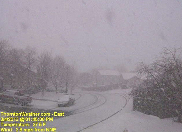
Snow covers the streets with Thornton's March 4, 2013 snowstorm. Within a couple of hours the sun was out and the streets were clear. (ThorntonWeather.com)

Perhaps we could call it the ‘Daylight Savings Storm of 2013’ or some other lame name like the Weather Channel uses.  Then again, we will stick with simply calling yesterday’s snowstorm a late winter storm that brought much-needed precipitation.

Leading up to yesterday’s storm all indicators were there for a significant shot of snow.  Forecasts varied a bit from outlet to outlet and some were disappointed that we didn’t receive as much as some forecasts said.  However within range with our forecasts for Thornton.

Snow began falling during the 4:00am hour on Saturday, March 9 and would continue for nearly 12 hours.  It was the first six hours that the most accumulation was recorded.  After that relatively warm temperatures and warm ground melted the snow as fast – and faster – than it was falling.

The one benefit of the fast melting is that Denver metro area roads never really became all that bad.  The story was quite different on the plains to the east where blowing snow prompted the closure of Interstate 70 for 24 hours or so.  Denver International Airport (DIA) did have more than 600 flights cancelled.

At its highest we recorded 5.6 inches of snow on the ground.  More than that certainly fell but the melting was taking its toll.  This brings Thornton’s seasonal snowfall total to 34.5 inches.

Officially Denver recorded 5.4 inches as measured at Denver International Airport.  The Mile High City’s seasonal total is now at 38.5 inches.

Best of all the heavy, wet snow contained a great deal of liquid precipitation.  Thornton saw 0.48 inch of precipitation and Denver 0.27 inch.  As parched as our landscape has been this winter this is very welcome.

Below is a time lapse video from our east webcam of the storm from start to finish – 14 hours in 28 seconds.  Scroll down below that for an interactive map of snowfall totals from across northeastern Colorado.

Live blogging the storm: View ThorntonWeather.com’s Facebook and Twitter feeds

ThorntonWeather.com on Facebook, Google+ and TwitterAs Thornton gets hit by a much-needed snowstorm, we are monitoring it very closely and posting regularly to our Facebook page and Twitter feed.  You can follow along in real time below.  We are also on Google+ here.
For comprehensive look at the storm, please monitor our Winter Weather Briefing page.