Weather – The true determining factor of who will be president?
We oftentimes hear about how weather can affect voter turnout but is there truly a link? If there is, who does it benefit – Republicans or Democrats? Studies seem to indicate that what might be thought of as an urban myth is indeed true and could in fact play a role in 2016.
In 2005, political science researchers Brad Gomez, Thomas Hansford and George Krause completed the first comprehensive study on the correlation between weather and voter turnout. Their paper, “The Republicans Should Pray for Rain: Weather, Turnout, and Voting in U.S. Presidential Elections” confirmed the conventional wisdom that weather does affect voter turnout, bad weather benefits Republicans and most interestingly, two presidential elections in the last 60 years may have had different results had the weather been different.
Looking back at presidential elections from 1948 to 2008, the study takes into account the weather in 3,000 U.S. counties. They in turn looked at key areas of the nation and how weather, good and bad, affected voter turnout. In the end, the study determined that precipitation is the key weather condition to affect voter turnout.
November 6 to November 12: This Week in Denver Weather History
Our look back at this week in Denver weather history is dominated with two types of events: snow and wind. November is our second snowiest month and we see many significant snowfall events in the past. Wind is a fact of life on the plains and in Denver and damaging events have occurred with relatively frequency as we can see below.
From the National Weather Service:
5-6
In 1938…heavy snowfall totaled 7.5 inches over downtown Denver. North winds were sustained to 16 mph with gusts to 19 mph on the 5th.
5-7
In 1918…rain was mixed with and changed to snow…which became heavy and totaled 8.1 inches in downtown Denver. North winds were sustained to 21 mph with gusts to 23 mph.
6
In 1962…west winds gusted to 55 mph…briefly reducing the visibility to 1 1/2 miles in blowing dust at Stapleton Airport. The strong winds blew all day.
In 1989…high winds to 62 mph were recorded in Boulder. Northwest winds gusted to 33 mph at Stapleton International Airport.
In 1991…strong westerly Chinook winds blew into metro Denver with gusts to 88 mph recorded at Rollinsville and to 51 mph in Boulder. Later…northeast winds with gusts of 30 to 40 mph were common across all of metro Denver behind a cold front…which produced only 0.2 inch of snowfall at Stapleton International Airport.
7
In 1958…a strong cold front produced northeast wind gusts to 52 mph at Stapleton Airport where some blowing dust was observed.
In 1980…Chinook winds at sustained speeds of 40 mph were recorded with a peak gust to 71 mph measured at Wondervu southwest of Boulder. West winds gusted to 25 mph at Stapleton International Airport.
In 1989…strong winds buffeted many foothills areas. Wind gusts of 60 to 70 mph were recorded in Boulder and Longmont. Northwest winds gusted to 43 mph at Stapleton International Airport.
In 1996…wind gusts to 75 mph were recorded at Golden Gate Canyon and at the Rocky Flats Environmental Test Facility northwest of Denver. Northwest winds gusted to 40 mph at Denver International Airport.
In 1998…upslope conditions…coupled with a moist and unstable air mass…allowed heavy snow to develop in the foothills west of Denver. Snowfall generally ranged from 4 to 6 inches…but 7 inches were measured 4 miles south of Evergreen. Only 1.2 inches of snow fell at the site of the former Stapleton International Airport. This was the first measurable snow of the season.
7-8
In 1969…wind gusts to 48 mph in downtown Boulder caused minor damage.
8
In 1896…southwest Chinook winds sustained to 42 mph with gusts as high as 46 mph warmed the temperature to a high of 53 degrees.
In 1977 near-blizzard conditions in blowing snow caused the closure of I-70 to the west of Denver in clear creek canyon and east of Denver to Limon. Northeast wind gusts to 46 mph were recorded at Stapleton International Airport where snowfall totaled only 1.1 inches.
In 1984…a rare November thunderstorm produced west winds gusting to 31 mph…but only 0.04 inch of rain at Stapleton International Airport.
In 1996…high winds gusting from 80 to 100 mph were recorded at Wondervu in the foothills southwest of Boulder. West northwest winds gusted to 32 mph at Denver International Airport.
In 2006…the temperature in Denver climbed to a high of 80 degrees. This was the first time the temperature had ever exceeded the 70’s in November since records began in 1872. This new all-time record maximum temperature for the month of November was also a new daily record and the highest temperature ever recorded so late in the season.
8-9
In 1897…west winds were sustained to 45 mph with gusts as high as 50 mph in the city.
In 1919…post-frontal heavy snowfall totaled 8.4 inches over downtown Denver. Most of the snow…6.6 inches…fell on the 9th. North winds were sustained to 26 mph with gusts to 30 mph on the 8th.
In 1950…a major winter storm dumped 10.4 inches of snow at Stapleton Airport with the most snow…7.8 inches…falling on the 8th. East winds gusted to 31 mph at Stapleton Airport on the 8th. Snowfall totaled 8.2 inches in downtown Denver.
In 1958…strong winds caused some damage in Boulder. West- northwest winds gusted to 40 mph at Stapleton Airport on the 8th.
In 1975…heavy snowfall hit metro Denver. Snowfall at Stapleton International Airport totaled 8.0 inches and east winds gusted to 21 mph. Power outages caused by the storm affected over 10 thousand people in metro Denver.
In the foothills west of Denver…10 to 15 inches of snow fell. The storm produced the greatest 24-hour precipitation…1.29 inches…ever recorded during the month of November in the city.
In 1983…metro Denver received 4 to 8 inches of snow with the heaviest amounts near the foothills. It was the first measurable snow of the season in Denver. Only 1.8 inches of snow fell at Stapleton International Airport where north winds gusted to 20 mph.
In 1989…strong winds hit the Front Range. On the 9th…the wooden frame of a house under construction in Boulder was blown down. The previous evening a power outage blackened Nederland. Wind gusts to 95 mph were recorded 4 miles south of Rollinsville with 97 mph on Fritz Peak near that town. At Stapleton International Airport…northwest winds gusted to 45 mph on the 8th and to 38 mph on the 9th.
In 1998…another upslope snow event developed in the Front Range foothills. The heaviest snowfall occurred in west central Jefferson County where 14 inches were measured 8 miles west of Conifer. Other snowfall totals included: 10 inches at Evergreen and 9 miles northwest of Bergen Park; 9 inches at Genesee…Nederland…and near the Chief Hosa exit on I-70; and 8 inches in Coal Creek Canyon. On the 9th…snowfall was 2.6 inches at the site of the former Stapleton International Airport. North-northeast winds gusted to 30 mph at Denver International Airport on the 9th.
8-10
In 1985…Indian summer came to an abrupt end when a winter storm dumped 10 to 18 inches of snow in the Front Range foothills and 6 to 10 inches across metro Denver…snarling traffic and causing flight delays of up to 3 hours at Stapleton International Airport. The temperature plunged from a high of 66 degrees on the 8th to a low of only 13 degrees on the 9th…after the passage of a vigorous cold front with northeast winds gusting to 32 mph. The temperature climbed to only 19 degrees on the 10th…setting a record low maximum for the date. Snowfall totaled 7.3 inches at Stapleton International Airport with most of the snow…7.1 inches…falling on the 9th.
The weather during the month of November in Denver metro area can offer just about anything. While it is normally a quiet month, it can be prone to extremes.
November is Denver’s second snowiest month and major snowstorms are not entirely uncommon. However conditions can also be quite dry.
Temperatures during the month continue to cool as we get closer to winter and by the end of the month the low temperatures routinely dip to 20 degrees or below. At times it can in fact bring conditions more like what we see in January.
Certainly given how warm and dry we were in October, we could use some relief. Will that happen?
High pressure was the dominant weather feature for the month of October and that led to a pattern that blocked off moisture and kept temperatures well above normal. Record-setting highs were made while precipitation was a rare event.
The historical average monthly temperature for the month of October in Denver is 50.9 degrees. That number was easily eclipsed. Here in Thornton we saw an average temperature of 55.8 degrees. Out at DIA where Denver’s official numbers are kept, it was much warmer with an average of 57.8 degrees.
Both averages for October 2016 were far above normal. Officially the month was so warm it became the fourth warmest October on record in Denver. The number one spot was quite secure though with an average of 59.9 degrees back in 1950.
Temperatures in Thornton ranged from a high of 84.8 degrees on the 16th down to a low of 27.1 degrees on the morning of the 20th. Out at the airport, the warmest reading was 86 degrees and the lowest 25 degrees, both on the same days that Thornton saw its warmest and coldest readings.
Denver recorded four record daily high temperatures during the month. The first record high came on the 15th of the month to be followed by records on the 27th and 28th then a tie for the record high on the 31st.
In terms of precipitation, the same high pressure that kept things warm, kept things dry as well. Thornton recorded a mere 0.43 inches in its rain bucket, all during the first half of the month. The airport was a bit drier with 0.26 inches recorded.
On average Denver receives 1.02 inches of precipitation in October so both locations were far below normal. While it was certainly dry, it was not so much so that it was a record-setter as the month failed to make it into the top 20 driest Octobers.
No snow was recorded during the month so we are still awaiting that first event of the season. This however is not entirely unusual as historically, 27% of Denver’s October fail to see any of the white stuff.
Thornton, Colorado’s October 2016 temperature summary. (ThorntonWeather.com)Thornton, Colorado’s October 2016 precipitation summary. (ThorntonWeather.com)
From the National Weather Service:
CLIMATE REPORT
NATIONAL WEATHER SERVICE DENVER/BOULDER CO
244 AM MDT TUE NOV 1 2016

...................................

...THE DENVER CO CLIMATE SUMMARY FOR THE MONTH OF OCTOBER 2016...

CLIMATE NORMAL PERIOD 1981 TO 2010
CLIMATE RECORD PERIOD 1872 TO 2016

WEATHER         OBSERVED          NORMAL  DEPART  LAST YEAR`S
                 VALUE   DATE(S)  VALUE   FROM    VALUE  DATE(S)
                                          NORMAL
................................................................
TEMPERATURE (F)
RECORD
 HIGH              89   10/16/1991
                        10/10/1910
 LOW               -2   10/29/1917
HIGHEST            86   10/16        83       3       87  10/11
LOWEST             25   10/20        22       3       28  10/28
AVG. MAXIMUM     74.5              65.3     9.2     70.1
AVG. MINIMUM     41.2              36.6     4.6     42.8
MEAN             57.8              50.9     6.9     56.5
DAYS MAX >= 90      0               0.0     0.0        0
DAYS MAX <= 32      0               0.4    -0.4        0
DAYS MIN <= 32      3               8.5    -5.5        1
DAYS MIN <= 0       0               0.0     0.0        0

PRECIPITATION (INCHES)
RECORD
 MAXIMUM         4.17   1969
 MINIMUM            T   1934
TOTALS           0.26              1.02   -0.76     1.76
DAILY AVG.       0.01              0.03   -0.02     0.06
DAYS >= .01         3               5.3    -2.3        6
DAYS >= .10         1               2.4    -1.4        3
DAYS >= .50         0               0.5    -0.5        2
DAYS >= 1.00        0               0.1    -0.1        0
GREATEST
 24 HR. TOTAL    0.22   10/05 TO 10/06           10/20 TO 10/21

SNOWFALL (INCHES)
RECORDS
 TOTAL             MM   MM
TOTALS            0.0               4.0

DEGREE_DAYS
HEATING TOTAL     231               440    -209      274
 SINCE 7/1        310               581    -271      301
COOLING TOTAL      17                 5      12       16
 SINCE 1/1        878               769     109      877

FREEZE DATES
RECORD
 EARLIEST     09/08/1962
 LATEST       06/08/2007
EARLIEST                        10/07
LATEST                          05/05
..................................................

WIND (MPH)
AVERAGE WIND SPEED              10.0
RESULTANT WIND SPEED/DIRECTION   4/197
HIGHEST WIND SPEED/DIRECTION    33/260    DATE  10/04
HIGHEST GUST SPEED/DIRECTION    42/270    DATE  10/03

SKY COVER
POSSIBLE SUNSHINE (PERCENT)   MM
AVERAGE SKY COVER           0.50
NUMBER OF DAYS FAIR           10
NUMBER OF DAYS PC             17
NUMBER OF DAYS CLOUDY          4

AVERAGE RH (PERCENT)     40

WEATHER CONDITIONS. NUMBER OF DAYS WITH
THUNDERSTORM              0     MIXED PRECIP               0
HEAVY RAIN                0     RAIN                       1
LIGHT RAIN                3     FREEZING RAIN              0
LT FREEZING RAIN          0     HAIL                       0
HEAVY SNOW                0     SNOW                       0
LIGHT SNOW                0     SLEET                      0
FOG                       4     FOG W/VIS <= 1/4 MILE      3
HAZE                      0

-  INDICATES NEGATIVE NUMBERS.
R  INDICATES RECORD WAS SET OR TIED.
MM INDICATES DATA IS MISSING.
T  INDICATES TRACE AMOUNT.
The United States returns to Standard Time at 2:00am Sunday as Daylight Saving Time comes to an end.
The biannual ritual of changing our clocks to adjust for Daylight Saving Time occurs tonight providing yet another signal of the changing of seasons. The United States will ‘fall back’ one hour at 2:00am Sunday morning as we return to Standard Time.
The ritual of changing our clocks twice a year can be met with some resistance as some people struggle to adjust their body’s internal clock. Others actually like the return to standard time as they get to enjoy an extra hour of sleep.
The time change definitely has big effects on the dawning of daylight and how early it gets dark in the evening.
Sunrise on Saturday occurs at 7:34am but on Sunday it will be at 6:35am. Similarly, sunset will occur at 5:53pm on Saturday but on Sunday the sun will disappear over the horizon at 4:52pm.
For many this means that when they get home from work it will now be dark and outdoor activities will be significantly curtailed as a result.
Arizona and Hawaii are the only states that do not observe Daylight Saving Time and remain on Standard Time year round. The U.S. territories of Puerto Rico, American Samoa, Guam, Northern Mariana Islands, and the United States Virgin Islands also do not observe the event.
It won’t be all that long though before Daylight Saving Time returns. On March 12, 2017 we will ‘spring forward.’
Daylight Saving Time Schedule
The mandated beginning and end of Daylight Saving Time has changed in the United States over the years.
The most recent schedule was set by the Energy Policy Act of 2005 and took effect in 2007. We now ‘spring forward’ to begin Daylight Saving Time on the second Sunday in March and ‘fall back’ with the return to Standard Time on the first Sunday in November.
October 30 to November 5: This Week in Denver Weather History
The further we go into the cold season, the more we see significant winter-like events in our look back at Denver weather history. Many significant snowstorms have occurred this week in the past including one in 1946 that dumped more than 30 inches of snow on Denver.
From the National Weather Service:
28-30
In 1971…a vigorous cold front plunged temperatures from a high of 70 degrees on the 27th to record low levels on the 29th and 30th. Snowfall totaled 3.1 inches at Stapleton International Airport where north winds gusted to 23 mph. Some freezing drizzle also fell on the 28th. Record daily low maximum temperatures of 32 degrees on the 28th and 25 degrees on the 29th were established along with a daily record minimum of 13 degrees on the 30th.
28-31
In 1929…rain changed to snow on the afternoon of the 28th and continued until midday on the 30th followed by intermittent light snow which continued through the 31st. Snowfall over the four days totaled 16.2 inches in the city. Most of the snow…8.5 inches…fell on the 29th with 6.1 inches on the 30th. Temperatures hovered in 20’s during most of the storm.
29-30
In 1905…heavy snowfall developed on the evening of the 29th and continued through the evening of the 30th. Snowfall totaled 11.0 inches in downtown Denver. Precipitation was 1.02 inches. Temperatures were generally in the 20’s.
In 1959…rain during most of the day on the 28th changed to snow early on the 29th and continued through most of the 30th. Heavy snowfall totaled 7.4 inches at Stapleton Airport. North-northeast winds gusted to 24 mph on the 30th. Some freezing drizzle also occurred on the 30th.
In 1981…4 to 8 inches of new snow were recorded in the foothills west of Denver. Snowfall totaled only 0.4 inch at Stapleton International Airport where north winds gusted to 25 mph.
29-31
In 1889…the first snowfall of the season totaled 14.0 inches over the three days in downtown Denver. Snowfall was 8.0 inches on the 29th and 5.0 inches on the 31st. North to northeast winds gusted to 30 mph on the 29th.
In 1950…a warm spell resulted in five daily temperature records. Record highs of 84…80…and 79 degrees occurred on the 29th…30th…and 31st…respectively. Low temperature of 49 degrees on the 30th was the record high minimum for the date.
In 1991…the second surge of cold arctic air in a matter of days plunged metro Denver into the deep freeze. While low temperatures remained above zero…high temperatures were only in the 20’s. Three temperature records were set: record lows of 7 degrees on the 30th and 10 degrees on the 31st and a record low maximum of only 21 degrees on the 30th. Snowfall was light with only 1.9 inches recorded at Stapleton International Airport where east winds gusted to 23 mph.
In 2002…snowfall totaled 4.3 inches at the site of the former Stapleton International Airport. North winds gusted to 32 mph on the 29th behind a cold front…which plunged temperatures well below seasonal normals. High temperatures of 18 degrees on the 30th and 19 degrees on the 31st were record low maximums for each date. Low temperatures dipped to 12 degrees on the 30th and 15 degrees on the 31st.
29-1
In 1972…heavy snowfall totaled 15.5 inches at Stapleton International Airport. However…the heaviest snow occurred on Halloween night when 7 inches fell on trick-or-treaters during a short 3-hour period. I-25 was closed south of Denver. North winds gusting to 29 mph caused some blowing snow on the 1st. The snow started late on the 29th and ended during the mid afternoon on the 1st. The greatest snow depth on the ground at Stapleton International Airport was 13 inches on the 1st.
30
In 1974…a rare thunderstorm for so late in October produced hail to 3/8 inch in diameter and 0.10 inch of rain at Stapleton International Airport.
In 1991…the high temperature warmed to only 21 degrees…the all-time record low maximum for the month of October. The same temperature also occurred on October 25…1997.
31
In 1997…high winds buffeted the foothills and adjacent areas of metro Denver. West winds gusted to 70 mph in Broomfield and to 40 mph at Denver International Airport. The strongest winds occurred in the mountains west of Denver and in the foothills north of Denver.
In 2001…high winds developed in the foothills. Peak wind gusts were measured to 74 mph at the National Center for Atmospheric Research on the mesa in Boulder and to 72 mph near Rollinsville. West winds gusting as high as 53 mph warmed the temperature to a high of 71 degrees at Denver International Airport.
31-1
In 1951…6.4 inches of snowfall were measured at Stapleton Airport.
In 1989…a Halloween storm dropped 3 to 6 inches of snow on metro Denver with the adjacent foothills receiving 5 to 10 inches. Snowfall totaled 4.5 inches at Stapleton International Airport…where north winds gusted to 31 mph on the 31st. Most of the snow fell on the evening of the 31st…but the storm left icy streets throughout metro Denver on the morning of the 1st…making it a “spooky” commute for many motorists.
In 2004…heavy snow fell in and near the foothills of Jefferson and Douglas counties. Storm total snowfall included: 14.5 inches in aspen park…10 inches at Boxborough state park and and near Sedalia…8 inches near bergen park…and 7 inches in Highlands Ranch. Snowfall totaled only 3.2 inches in the Denver Stapleton area. Post-frontal northeast winds gusted to 41 mph at Denver International Airport.
1
In 1896…northwest Chinook winds sustained to 40 mph with gusts to 46 mph warmed the temperature to a high of 60 degrees in the city.
In 1973…wind gusts to 92 mph were recorded in Boulder. West winds gusted to 41 mph at Stapleton International Airport where the Chinook winds warmed the temperature to a high of 70 degrees.
In 1989…a 39-year-old Lakewood man in a motorized wheelchair was found dead of exposure early in the morning after an overnight snowfall dumped 3 to 6 inches of snow across metro Denver.
1-2
In 1892…snowfall totaled 5.0 inches in downtown Denver. This was the only snow of the month.
In 1956…heavy snowfall totaled 7.0 inches at Stapleton Airport. The storm was accompanied by much blowing and drifting snow. North winds gusted to 47 mph.
In 1991…the storm system which hit the Front Range at the end of October finished the job during the start of November. Six inches of new snow were recorded at both Rollinsville and Morrison…while 2.9 inches of snow fell at Stapleton International Airport where northeast winds gusted to 17 mph. The temperature climbed to a high of only 19 degrees on the 2nd…setting a record low maximum for the date.
In 1995…a winter storm dropped 5 to 8 inches of snow in the Front Range foothills. The exception was at Golden Gate Canyon where a foot of new snow was measured. Icy roads…fog…and blowing snow along I-70 in the foothills west of Denver caused dozens of accidents. One man was killed when he lost control of his vehicle and was ejected when his truck hit a median and rolled over. At least 20 other accidents involved minor injuries. Only 1.0 inch of snow fell at the site of the former Stapleton International Airport where some freezing rain also fell.
2
In 1939…a trace of snow fell over downtown Denver. This snow…along with a trace of snow on the 9th…was the only snow of the month…ranking it…along with other months…the second least snowiest November on record.
In 1967…post-cold frontal heavy snowfall totaled 6.2 inches at Stapleton International Airport where north winds gusted to 29 mph…briefly reducing the visibility to 1/8 mile.
In 1992…the first major snowfall of the season dumped 4.6 inches of snow at Stapleton International Airport where north winds gusted to 26 mph. Heavier amounts of snow fell in and near the foothills with 8 inches at conifer… Empire…and Bailey…6 inches at Rollinsville and Golden Gate Canyon…and 4 inches at Morrison and Wheat Ridge.
In 2011…a storm system brought another around of moderate to heavy snow to the region. Areas in and near the Front Range Foothills and Palmer Divide were hit the hardest. Gusty winds also produced blizzard conditions at times along the Palmer Divide. In addition…the snow and blowing snow forced several school closures in Douglas and Weld Counties. Snow drifts…from 1 to 3 feet deep were reported in the northern portion of Douglas and Elbert Counties. Storm totals included: 14 inches…4 miles south of Boulder and 12.5 miles northwest of Golden…13 inches… 5 miles east-southeast of Aspen Springs; 12 inches near Allenspark and Parker; 11 inches…6 miles southwest of Castle Rock…Genessee… 9 miles north-northeast of Elizabeth…10 inches… 10 miles south-southeast of Buckley AFB. At the National Weather Service in Boulder… 7.9 inches of snow was recorded…with 4.5 inches observed at Denver International Airport.
A stunning sunset starts off October 2016 in fine form. (Mary Lindow)
October in Thornton can bring a wide variety of weather conditions, perfect for the photographer in all of us.
The month brings the changing of the colors at Colorado’s lower elevations and it is also is typically when we see our first freeze and first snow.
Couple those facts with our usual widely varying landscapes and wildlife and we have a month that is sure to bring in plenty of photo opportunities.
Slideshow updated October 31, 2016
To learn more about how to send your photo to us for inclusion in the slideshow, see below the slideshow.
Showcasing images captured by ThorntonWeather.com readers as well as some of our own, our monthly slideshow covers the entire gamut of weather-related imagery.
Sunsets, sunrises, wildlife and of course every type of weather condition are vividly depicted in images captured from yours and our cameras.
[flickr_set id=”72157674923421206″]
What is missing in the slideshow above? Your photo!
Our monthly photo slideshow is going to feature images that we have taken but more importantly images that you have captured. The photos can be of anything even remotely weather-related.
Landscapes, current conditions, wildlife, pets, kids. Whimsical, newsy, artsy. Taken at the zoo, some other area attraction, a local park, a national park or your backyard. You name it, we want to see and share it!
Images can be taken in Thornton, Denver or anywhere across the extraordinary Centennial State. We’ll even take some from out of state if we can tie it to Colorado somehow.
We’ll keep the criteria very open to interpretation with just about any image eligible to be shown in our slideshows.
What do you win for having your image in our slideshow? We are just a ‘mom and pop’ outfit and make no money from our site so we really don’t have the means to provide prizes. However you will have our undying gratitude and the satisfaction that your images are shared on the most popular website in Thornton.
To share you images with us and get them included in the slideshow just email them to us or share them with ThorntonWeather.com on any of the various social media outlets. Links are provided below.
The month of October is ending the same way it has been the majority of the month with above normal temperature readings. Denver has in fact tied the record high temperature for Halloween making it the fourth record high temperature set this month.
At 12:24pm the National Weather Service reported 79 degrees at Denver International Airport. This typed the record high for October 31 last set in 1950.
Here in Thornton we were just a couple degrees warmer with a high of 81 degrees at 3:12pm.
Today’s record-tying reading follows three record high temperatures set earlier this month on October 15th, the 27th and the 28th.
Stay up to date with Thornton’s weather: ‘Like’ us on Facebook, follow us on Twitter and add us to your Google+ circles
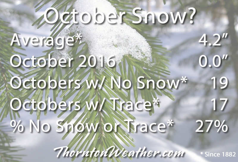
The lack of measurable snow this October is not all that unusual. Click for larger view.
October will end with Denver not having seen any snow accumulation at all during the month. While that, coupled with the overall lack of precipitation is concerning, not having snow is not at all unusual.
On average, the Mile High City receives 4.2 inches during October.
However, since record-keeping began in 1882, the month failed to yield any snow at all in 19 years since. Further, in another 17 of those years we only received a trace.
This means that in 27% of the past 134 years, we saw essentially no accumulating snow in October. So, the fact we won’t have received any this month is not uncommon.
The average date for our first snowfall is October 18th so we aren’t running all that far behind. The earliest seasonal snowfall came on September 3, 1961 and the latest on November 21, 1934.
We have been exceedingly dry, really since the first part of June.
In October, Denver has recorded a mere 0.26 inches of precipitation while here in Thornton we have fared better with 0.43 inches. On average we expect to see 0.97 inches so both locations are well below normal.
Perhaps more notable than the lack of moisture is the temperatures which have been unseasonably warm.
As of right now, the average temperature for the month is at 57.2 degrees in Denver, 55.1 degrees in Thornton. This is running far above the historical October average temperature of 50.9 degrees.
Depending on temperatures between now and the end of the month, it is looking likely that October 2016 will finish somewhere in the top five or six warmest Octobers on record.
Following on yesterday’s record-setting performance, the mercury once again rose to levels never before seen on this date.
At 12:53pm the station at Denver International Airport reported 82 degrees. This easily bested the previous record for October 28 of 80 degrees last set in 1994.
Here in Thornton we were actually a bit warmer reaching 83 degrees at 3:34pm.
At this time it is certain that October 2016 will go into the record books as one of the 10 warmest Octobers in Denver history. Where it ends up on the list is yet to be determined but it is likely to be around the fourth or fifth warmest.
Weather, natural disasters & climate news and information.


 The weather during the month of November in Denver metro area can offer just about anything. While it is normally a quiet month, it can be prone to extremes.