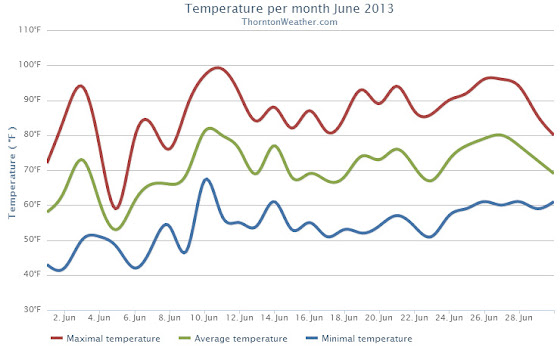
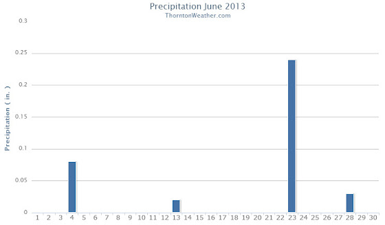
In writing the history of the weather for the area for June 2013 two words come to mind: hot and dry. While both conditions were certainly prevalent, we can at least be consoled by the fact that it could have been worse.
The month actually started cooler than normal with six of the first seven days recording below average temperatures. Soon though high pressure built over the area and temperatures began to climb with many days for the balance seeing above normal mercury readings.
Thunderstorms did occur during the month but not with any particularly notable frequency or ferocity. Most notable though was a tornado that struck near Denver International Airport on the 18th of the month. The twister was responsible for Denver’s peak wind gust of the month of 97 mph.
June 2013 wrapped up with an average temperature in Thornton of 70.5 degrees. This was well above Denver’s historical average for the month of 67.4 degrees. Officially Denver’s average temperature last month was 71.1 degrees, warm enough to put it in a tie for the 10th warmest June in Denver history.
In all, Thornton recorded 10 days with mercury readings above 90 degrees. Denver saw 14.
The warmest temperature of the month in Thornton was 99.2 degrees on the 11th. That same day Denver hit 100 degrees, its high reading of the month.
Thornton’s coldest temperature came on the 6th when the temperature dropped to 41.6 degrees. Denver’s officially bested that with a low temperature for the month of 39 degrees on the 2nd.
Denver officially broke three temperature records during the month:
In terms of precipitation the month was certainly dry but not the worst we have seen. Thornton recorded a scant 0.49 inch in the rain bucket. Denver bested us slightly by recording 0.75 inches. Both measurements were far below the 1.98 inch historical average for June but certainly better than the driest June on record in 1890 when only a trace was recorded.
Click here to view Thornton’s June 2013 climate summary.


CLIMATE REPORT
NATIONAL WEATHER SERVICE BOULDER, CO
210 AM MDT MON JUL 1 2013

...................................

...THE DENVER CO CLIMATE SUMMARY FOR THE MONTH OF JUNE 2013...

CLIMATE NORMAL PERIOD 1981 TO 2010
CLIMATE RECORD PERIOD 1872 TO 2013

WEATHER         OBSERVED          NORMAL  DEPART  LAST YEAR`S
                 VALUE   DATE(S)  VALUE   FROM    VALUE  DATE(S)
                                          NORMAL
................................................................
TEMPERATURE (F)
RECORD
 HIGH             105   06/26/2012
                        06/25/2012
                        54/01/2206
 LOW               30   06/02/1951
HIGHEST           100   06/11       104      -4      105  06/26
                                                          06/25
LOWEST             39   06/02        30       9       43  06/11
AVG. MAXIMUM     87.8              82.4     5.4     91.7
AVG. MINIMUM     54.3              52.3     2.0     58.4
MEAN             71.1              67.4     3.7     75.0
DAYS MAX >= 90     14               7.9     6.1       17
DAYS MAX <= 32      0               0.0     0.0        0
DAYS MIN <= 32      0               0.0     0.0        0
DAYS MIN <= 0       0               0.0     0.0        0

PRECIPITATION (INCHES)
RECORD
 MAXIMUM         4.96   1882
 MINIMUM            T   1890
TOTALS           0.75              1.98   -1.23     1.22
DAILY AVG.       0.03              0.07   -0.04     0.04
DAYS >= .01         4               8.4    -4.4        2
DAYS >= .10         2               4.6    -2.6        2
DAYS >= .50         1               1.4    -0.4        2
DAYS >= 1.00        0               0.3    -0.3        0
GREATEST
 24 HR. TOTAL    0.51   06/23 TO 06/23           06/06 TO 06/07
                        06/22 TO 06/23                    06/23 TO 06/23
                        06/23 TO 06/23                    06/23 TO 06/23
 STORM TOTAL       MM                                 MM
 (MM/DD(HH))            MM                    06/07(00) TO 06/07(00)
                                                 06/23(00) TO 06/23(00)3
                                                 06/23(00) TO 06/23(00)3

SNOWFALL (INCHES)
RECORDS
 TOTAL             MM   MM
TOTALS            0.0               0.0

DEGREE_DAYS
HEATING TOTAL      29                62     -33        6
 SINCE 7/1       6084              6058      26     5399
COOLING TOTAL     221               133      88      314
 SINCE 1/1        263               155     108      365

FREEZE DATES
RECORD
 EARLIEST     09/08/1962
 LATEST       06/08/2007
EARLIEST      03/01             10/07
LATEST        04/24             05/05
....................................................

WIND (MPH)
AVERAGE WIND SPEED              10.7
RESULTANT WIND SPEED/DIRECTION   2/156
HIGHEST WIND SPEED/DIRECTION    64/060    DATE  06/18
HIGHEST GUST SPEED/DIRECTION    97/040    DATE  06/18

SKY COVER
POSSIBLE SUNSHINE (PERCENT)   MM
AVERAGE SKY COVER           0.50
NUMBER OF DAYS FAIR            6
NUMBER OF DAYS PC             23
NUMBER OF DAYS CLOUDY          1

AVERAGE RH (PERCENT)     42

WEATHER CONDITIONS. NUMBER OF DAYS WITH
THUNDERSTORM              0     MIXED PRECIP               0
HEAVY RAIN                3     RAIN                       2
LIGHT RAIN                7     FREEZING RAIN              0
LT FREEZING RAIN          0     HAIL                       0
HEAVY SNOW                0     SNOW                       0
LIGHT SNOW                0     SLEET                      0
FOG                       4     FOG W/VIS <= 1/4 MILE      0
HAZE                      6

-  INDICATES NEGATIVE NUMBERS.
R  INDICATES RECORD WAS SET OR TIED.
MM INDICATES DATA IS MISSING.
T  INDICATES TRACE AMOUNT.
