Somewhat of a mixed bag for Thornton’s weather in August. While we enjoyed temperatures near normal without too many extremes, precipitation was lacking considerably from what we expect during the month.
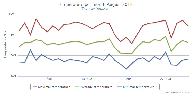
The month started out toward the cool side but with days of above normal temps interspersed. For the first few weeks it appeared we would end up a good bit cooler than normal but then the heat returned for much of the last week driving up average temperatures.
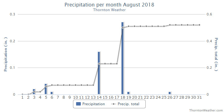
Precipitation was quite disappointing with only a couple decent rainfalls during the month and a few minimal events.
Probably the most notable thing for the month was the relatively persistent haze from smoke from wildfires to our west. While it made for pretty sunrises and sunsets, it obscured our normally beautiful blue skies.
Thornton finished the month with an average temperature of 70.4 degrees. That is more than two degrees cooler than Denver’s long term August average of 72.5 degrees. As is the norm, Denver’s official measurement came in a good bit warmer with an average of 72.4 degrees.
Our highs ranged from a maximum of 94.9 degrees on the 4th of the month down to a low of 47 degrees on the morning of the 20th. Denver matched our maximum on the same date and saw a low of 46 degrees on the 20th which also tied the record low for the date.
The month saw a paltry 0.52 inches fall in Thornton’s rain bucket. Denver actually fared better with 0.93 inches. Both measurements however fell short of the August average of 1.69 inches.
Click here to view Thornton’s August 2018 climate report.
CLIMATE REPORT
NATIONAL WEATHER SERVICE DENVER/BOULDER CO
318 PM MDT SAT SEP 1 2018

...................................

...THE DENVER CO CLIMATE SUMMARY FOR THE MONTH OF AUGUST 2018...

CLIMATE NORMAL PERIOD 1981 TO 2010
CLIMATE RECORD PERIOD 1872 TO 2018

WEATHER         OBSERVED          NORMAL  DEPART  LAST YEAR`S
                 VALUE   DATE(S)  VALUE   FROM    VALUE  DATE(S)
                                          NORMAL
................................................................
TEMPERATURE (F)
RECORD
 HIGH             105   08/08/1878
 LOW               40   08/26/1910
                        08/25/1910
                        08/24/1910
                        08/22/1904
HIGHEST            95   08/04       105     -10       95  08/19
LOWEST             46   08/20        40       6       51  08/04
AVG. MAXIMUM     86.8              87.2    -0.4     85.7
AVG. MINIMUM     58.0              57.9     0.1     57.3
MEAN             72.4              72.5    -0.1     71.5
DAYS MAX >= 90     11              11.5    -0.5       10
DAYS MAX <= 32      0               0.0     0.0        0
DAYS MIN <= 32      0               0.0     0.0        0
DAYS MIN <= 0       0               0.0     0.0        0

PRECIPITATION (INCHES)
RECORD
 MAXIMUM         5.85   1979
 MINIMUM         0.02   1924
TOTALS           0.93              1.69   -0.76     1.86
DAILY AVG.       0.03              0.05   -0.02     0.06
DAYS >= .01         7               8.6    -1.6        6
DAYS >= .10         2               4.3    -2.3        4
DAYS >= .50         0               1.2    -1.2        2
DAYS >= 1.00        0               0.3    -0.3        0

GREATEST
 24 HR. TOTAL    0.38   08/14 TO 08/14

SNOWFALL (INCHES)
 TOTAL            0.0
RECORD
 TOTAL            0.0               0.0

DEGREE_DAYS
HEATING TOTAL       9                10      -1        8
 SINCE 7/1          9                16      -7        8
COOLING TOTAL     247               244       3      216
 SINCE 1/1        862               688     174      749

FREEZE DATES
RECORD
 EARLIEST     09/08/1962
 LATEST       06/08/2007
EARLIEST                        10/07
LATEST                          05/05
.................................................................

WIND (MPH)
AVERAGE WIND SPEED              10.3
RESULTANT WIND SPEED/DIRECTION   3/176
HIGHEST WIND SPEED/DIRECTION    41/280    DATE  08/27
HIGHEST GUST SPEED/DIRECTION    60/270    DATE  08/27

SKY COVER
POSSIBLE SUNSHINE (PERCENT)   MM
AVERAGE SKY COVER           0.50
NUMBER OF DAYS FAIR           12
NUMBER OF DAYS PC             17
NUMBER OF DAYS CLOUDY          2

AVERAGE RH (PERCENT)     48

WEATHER CONDITIONS. NUMBER OF DAYS WITH
THUNDERSTORMS             9   MIXED PRECIP           0
HEAVY RAIN                1   MODERATE RAIN          3
LIGHT RAIN               12   FREEZING RAIN          0
LT FREEZING RAIN          0   HAIL                   0
HEAVY SNOW                0   SNOW                   0
LIGHT SNOW                0   FOG W/VIS <=1/4 MILE   2
FOG                       4   HAZE                   8

-  INDICATES NEGATIVE NUMBERS.
R  INDICATES RECORD WAS SET OR TIED.
MM INDICATES DATA IS MISSING.
T  INDICATES TRACE AMOUNT.