Tag Archives: tornado

Storm Chase 2010 wraps up – Chasers experience it all from sunsets to tornadoes

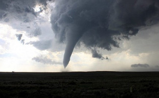
The Memorial Day tornado in Baca County, Colorado near Campo was the highlight of a week of storm chasing but it wasn’t the only exciting thing to happen. (Tony Hake / ThorntonWeather.com)

We have said before that storm chasing is as much an art as a science and it can very much be feast or famine.  Both extremes were seen over the course of a week of storm chasing on the Great Plains by ThorntonWeather.com.

We hope our site visitors were checking out the Storm Chase 2010 Examiner where we were documenting our chase across America’s heartland.  With stories, photos and video, the entire incredible week has been described in detail.

Two ‘busted’ storm chase days started out the week – one with a round trip from Denver to Nebraska and another one-way to Amarillo, Texas.  Those certainly fulfilled the ‘famine’ part of storm chasing. 

The third day however brought a ‘feast’ in the form of a bounty of five tornadoes in one day.  Chasing storms in southeastern Colorado, ThorntonWeather.com witnessed the entire gamut of severe weather from drenching rain and damaging hail to gale force winds and of course tornadoes. 

The first tornado of that day near Pritchett, Colorado allowed chasers to witness the complete tornado genesis.  As massive amounts of air were sucked into a storm cell and the clouds swirled menacingly above, a small funnel cloud soon grew into a powerful tornado. 

Two other tornadoes and an incredible hail storm on the virtually barren ranchland followed.  The main event was yet to come however. 

About eight miles south of Campo, Colorado, a massive supercell seemed poised to generate a tornado.  Chasers waited anxiously as the sky grew darker on the plains.  A funnel cloud formed and was cheered on as it grew closer to the ground. 

Before long the tornado was on the ground moving at a leisurely 10 mph – its slow pace allowing for plenty of time to capture amazing photos and video of the event.  The Baca County tornado would draw national media attention and will possibly go down as the most picturesque of all twisters during the 2010 tornado season.

While the Memorial Day tornadoes would be the last seen during the week, they were not the last extraordinary weather event witnessed by the storm chasers. 
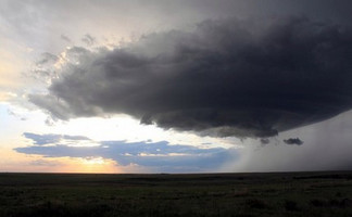
Storm Chase 2010 intercepted a flying saucer over western Kansas at the end of a very long chase day. (Tony Hake / ThorntonWeather.com)

Two days after the southeastern Colorado tornadoes, chasers witnessed an extraordinary ‘mothership’ supercell near Goodland, Kansas.  The sight of the ‘flying saucer’ slowly moving across the Kansas wheat fields was extraordinary.

Central Nebraska proved to be the backdrop for another day of weather beauty.  Waiting patiently at a small town gas station, multiple super cells moved across the area and chasers were on the move.  From highways to dirt roads, the chasers saw the storms generate amazing shelf clouds and funnel clouds.

In the end, the group of storm chasers covered over 2,500 miles across five states.  They witnessed many funnel clouds and amazing storm structures and of course five tornadoes, two of which were at close range.  For many it was truly a once in a lifetime experience that allowed them to see Mother Nature’s fury up close and personal.   

Complete stories, photos and video from Storm Chase 2010:

Hail and tornadoes make for eventful Wednesday afternoon

Hail covers the road at 104th Avenue and Chambers Road on Wednesday afternoon. (Chelsea Kovach)

Colorado’s severe weather season is upon us and it paid a visit to the north Denver metro area in spades on Wednesday. Brief, heavy rain, large hail and a few tornadoes were reported with the fast moving storms.

Isolated thunderstorms began popping up along the Front Range after lunchtime, quickly turning severe in nature.

Hail nearly three inches in diameter pounded vehicles and homes in north Denver, Commerce City, Thornton and unincorporated Adams County. Enough hail fell in the Reunion development area of Commerce City to cover the ground like snow. Residents used snow blowers and state highway crews used snowplows to clear the frozen water.

An untold number of vehicles sustained heavy damage in the area northeast of downtown Denver. Reports of broken windows, roofs with damage and trees stripped of leaves were commonplace.  In the central part of Thornton there were reports of hail up to 1.75 inches in diameter.

Operations at Denver International Airport were affected as flights were delayed while the severe weather passed. Delays of 30 to 60 minutes were experienced and those inside the airport were instructed to go to designated tornado shelters for a time.

Brief, weak tornadoes were reported in some areas and strong winds caused damage further northeast of the area. In Larimer County, multiple structures were reportedly destroyed and a 15 foot silo was knocked down.

The severe weather was enough to draw the attention of the VORTEX 2 tornado study. The research study is the largest field study of tornadoes with hundreds of scientists and dozens of vehicles roaming the plains to learn more about the severe weather. The teams tracked the storms as they moved from near DIA to the plains further to the northeast.

Are you ready for severe weather?  Do you know what to do to keep you and your family safe? Review our Severe Weather 101 series to learn more:

ThorntonWeather.com set to chase tornadoes on the Great Plains

ThorntonWeather.com's chief amateur meteorologist will be on the hunt for tornadoes starting next week.  Be sure to follow along!
ThorntonWeather.com's chief amateur meteorologist will be on the hunt for tornadoes starting next week. Be sure to follow along!

Severe weather season brings danger and destruction to the Great Plains of the United States. No other place on earth sees as many tornadoes as this region and now ThorntonWeather.com is going to go on the hunt in an attempt to witness Mother Nature’s fury up close and personal.

As we have pointed out before, the owner and operator of ThorntonWeather.com writes weather, disaster and climate news for Examiner.com.  This allows Tony to share his passion for the topics and also helps to pay for all the great features ThorntonWeather.com visitors enjoy.

Starting Sunday, May 30th and for the six days following, one Examiner will seek out and attempt to witness and document these events. World famous storm chaser Roger Hill will serve as tour guide and teacher for the Examiner and a group of weather enthusiasts as they hunt the ultimate prize – tornadoes.

An average of over 1,300 tornadoes have struck the United States in each of the last three years claiming more than 200 lives total. These devastating events can strike with little warning and with a fury unseen with any other natural phenomena.

After a slow start to the season in 2010, recent weeks have seen activity ramp up to much more normal levels. Tornadoes ripped through Oklahoma on May 11th killing five and just this past weekend a monstrous EF4 twister carved a path through rural South Dakota.

We will be bringing along Examiner and ThorntonWeather.com readers on this great chase. There are no guarantees because as we all know, Mother Nature is far from reliable – six days on the plains could yield little more than rain. However, confidence is high that you will be taken on a virtual ride unlike any other with videos, photos and more from the road.

To keep things simple, ThorntonWeather.com’s chief amateur meteorologist will be primarily posting things to the Storm Chase 2010 Examiner’s home page.  To be sure you don’t miss a thing, check the Storm Chase 2010 Examiner’s home page regularly. Be sure to click the “Subscribe” link at the top of the page and you will be emailed whenever a new story is posted.

Also, we will be posting regular updates from the road on Twitter via the Natural Disasters Examiner – click here to follow. On Facebook, be sure to ‘become a fan’ / ‘like’ the Natural Disasters Examiner as well to receive the latest right on there too.

On the net:

Monster EF3 tornado rips through South Dakota

A powerful half-mile wide tornado ripped through South Dakota on Saturday, May 22, 2010. (NWS)  Watch video of the twister and see a slideshow of the damage below.
A powerful half-mile wide tornado ripped through South Dakota on Saturday, May 22, 2010. (NWS) Watch video of the twister and see a slideshow of the damage below.

A massive tornado reminiscent of a famous tornado in the state’s history ripped through central South Dakota on Saturday. The powerful twister appears to have been an EF3 tornado packing winds of over 160 mph and while damage to homes was recorded, miraculously no one was injured.

Supercell thunderstorms began forming on the South Dakota plains yesterday afternoon and began spawning tornadoes. The twisters were reported near the towns of Bowdle, Hosmer, Ipswich and Wetonka.

The National Weather Service’s Aberdeen, SD office reported that the largest of these appears to have done at least EF3 level damage, a level classified as “severe.” The twister tore through parts of Brown and McPherson Counties coming closes to the town of Bowdle.

The storm damage evaluation is ongoing but National Weather Service personnel said the tornado was at least one-half mile wide at its largest. No injuries were reported however three farms were damaged and numerous power lines were downed.

Images of the storm drew parallels to a tornado on June 24, 2003 that struck the town of Manchester, South Dakota. That twister, rated an F4, destroyed the town and to this day it has not been rebuilt. The photos of both events looked eerily similar.

Slideshow - Tornado damage from Bowdle, SD, May 22, 2010.

Tornadoes kill 5 in Oklahoma – Video from storm chasers

A screenshot of video taken of a multiple=
A screenshot of video taken of a multiple vortex tornado that struck in Oklahoma on Monday, May 10, 2010. Watch the video below. (Scott Weberpal / Ryan Wichman)

It is a little known but amazing phenomenon that sometimes accompanies tornadoes – multiple vortices coming from one larger twister. Storm chasers descended on the area of yesterday’s deadly tornado outbreak and two were able to capture amazing video of what looks like small tornadoes circling a larger twister.

When witnessed from the ground, multiple vortex tornadoes are an amazing sight. The larger twister will appear no different than what one might expect, but smaller vortices will be seen rapidly circling around and through the main funnel.

These suction vortexes are usually short-lived and will die out as the main funnel moves and then new satellites will reappear. These satellite vortices are oftentimes present but not visible due to debris and clouds.

Storm chaser team Scott Weberpal and Ryan Wichman captured amazing video of a multiple vortex tornado as it tore through the Oklahoma countryside. Watch the video below.

Colorado researchers join VORTEX2 tornado project

This tornado in Goshen County, Wyoming in 2009 was intercepted by VORTEX2 teams and is considered the “most intensely examined tornado in history.” (NOAA)  Watch video of the twister and see more photos at the complete story on Examiner.com. (NOAA)
This tornado in Goshen County, Wyoming in 2009 was intercepted by VORTEX2 teams and is considered the “most intensely examined tornado in history.” (NOAA) Watch video of the twister and see more photos at the complete story on Examiner.com. (NOAA)

For the second year in a row, a team of over 100 scientists and dozens of vehicles will take to Tornado Alley in an attempt to study one of Mother Nature’s most destructive phenomena. Like last year, Colorado researchers will be helping with the project.

Among the Colorado-based participants are University of Colorado students and researchers. They join others from 11 other universities from across the nation including the University of Oklahoma, Penn State University, and the University of Massachusetts.

Perhaps most well known, Dr. Josh Wurman of the Center for Severe Weather Research (CSWR) in Boulder will be a key contributor. Watchers of the Discovery Channel’s Storm Chasers series know Wurman well as the operator of a Doppler On Wheels (DOW) radar truck and coordinator of the TV series’ storm chases.

Verification of the Origins of Rotation in Tornadoes Experiment 2 (VORTEX2) is simply the largest, most extensive in-field tornado study in history. Funded by the National Science Foundation (NSF) and the National Oceanic and Atmospheric Administration (NOAA), the VORTEX2 team will prowl the Great Plains hunting their elusive prey from May 1st to June 15th.

Once again, a veritable armada of scientific equipment will be deployed. Ten mobile radar units, dozens of vehicles, over 70 other instruments and even an Unmanned Aerial Vehicle (UAV) will cover thousands of miles on the Great Plains.

There's more to this story on Examiner.com!For the rest of this story including photos of all the equipment and amazing video of the tornado in Wyoming that the team intercepted last year, visit the Denver Weather Examiner.
Severe weather outbreak turns deadly, 10 killed in Mississippi

Storm Prediction Center reports for Saturday, April 24, 2010
Storm Prediction Center reports for Saturday, April 24, 2010. Click on the image for a slideshow of the damage.

Severe weather across the South on Saturday turned deadly as tornadoes ripped through the region. Mississippi was hardest hit as one twister in Yazoo County killed 10 people and officials fear more could lie buried under the rubble.

Yazoo County was ground zero for the worst of the devastation where officials estimate 100 homes were destroyed. Mississippi Governor Haley Barbour described the scene as “utter obliteration.”

Images of the scene were heart wrenching and show homes reduced to nothing but scattered lumber. A church was destroyed, cars tossed about like toys and trees snapped like twigs and left without foliage.

Widespread power outages were reported as power lines were downed by the intense fury of the storms.  Officials said thousands remained without power as of Sunday morning.

The human toll was staggering and covered three Mississippi counties. Five people were killed in Choctaw County, four in Yazoo County and one in Holmes County. The Mississippi Emergency Management Agency reported that two children were among the dead including a three month old baby.

Get the rest of this story including photos of the destruction from the Natural Disasters Examiner.

Statewide tornado drill to occur in Colorado on Wednesday

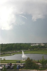
This funnel cloud was seen from the Thornton Civic Center (looking north) on June 10, 2009. Image courtesy Lisa Wilson, the City of Thornton.

If you happen to be outside or listening to broadcast media this morning, don’t be surprised to hear a tornado warning / siren. As part of Severe Weather Awareness Week, the National Weather Service will be conducting a statewide tornado test around 9:15am.

The service is urging all government agencies, schools, businesses, broadcast media and emergency management agencies to participate in this important drill.

This is a good time for citizens to ensure they are prepared and know what to do when a tornado strikes. As we saw with last year’s tornado activity and in 2008 with the Windsor tornado, twisters can and do strike the Denver area. Preparation and planning are critical to ensuring you and your family remain safe.

It is perhaps most fitting that Colorado saw its first tornado of 2010 yesterday. The twister which struck in Kit Carson County 11 miles south-southwest of Bethune caused no damage. However, it serves as an important reminder.

Will you hear tornado sirens in Thornton?  Unfortunately not.  The city does not have a warning system in place.  Find out why.

Do you know what to do when a tornado strikes?  Learn what you can do to protect you and your family here.

85 years ago today – The nation’s deadliest tornado

A Chicago Herald Examiner headline covering the Great Tri-State Tornado of 1925. (Wikipedia)  Follow the link below for images of the destruction.
A Chicago Herald Examiner headline covering the Great Tri-State Tornado of 1925. (Wikipedia) Follow the link below for images of the destruction.

News reports portray a dreary start to March 18, 1925 with heavy rain in the morning but nothing that would foretell the disaster that was to come. Before the day was over, parts of Missouri, Illinois and Indiana would be torn asunder and nearly 700 people would be dead.

Today marks the 85th anniversary of what we now call the Tri-State Tornado. The deadly twister was of the likes that had never been seen before – and hasn’t been seen since. That morning, the U.S. Weather Bureau’s forecast called for “rains and strong shifting winds.” Nothing that would indicate the horror that was to come.

The first reports of the tornado happened at 1:01pm near Ellington, Missouri. As it moved to the northeast the twister tore through the towns of Annapolis, Redford, Cornwall, Biehle, and Frohna. By the time it exited Missouri, 11 people were dead.

Illinois bore the brunt of the tornado as it continued on its deadly path. It crossed the Mississippi River and tore through Gorham, Johnston City, Murphysboro, De Soto, Hurst-Bush and a half dozen other Illinois towns. Entire towns were reduced to rubble, over a thousand people were injured and 613 people in the state were dead.

Far from over, the twister crossed into Indiana where the towns of Griffin, Owensville, and Princeton were hit. 71 people are thought to have died in the state.

The horror finally came to an end at 4:30pm, three and a half hours after it started. The tornado dissipated southwest of Petersburg, Indiana but not until after it had covered a path of at least 219 miles and left death and destruction the entire way. From southeastern Missouri, completely across southern Illinois and into southwestern Indiana, the tornado was the longest tracking twister ever recorded.

For more about the deadly tornado, maps of the path and images of the aftermath, read the complete story on the Natural Disasters Examiner.

Video – Tornado rips through western Oklahoma

A tornado ripped through western Oklahoma on Monday destroying five homes and a barn. Dramatic video captured by stormchasers show the twister ripping apart out-buildings as it crosses a highway near Hammon.

According to the Storm Prediction Center, the twister was reported at 5:57pm local time. Residents said the area’s warning sirens did sound and provided nine minutes of warning before the tornado struck.

Oklahoma Department of Emergency Management spokeswoman Michelann Ooten told the Associated Press that no injuries were reported. In addition to the five homes, a barn owned by the county was destroyed and the roofs of several homes were blow off.

Stormchasers were tracking the storm and captured amazing video of the twister from the distance and from very close proximity.  The first is from Arick Inman and the second from Mike Scantlin.