|
Tag Archives: tornado
National Weather Service rates damaging May 24 tornadoes
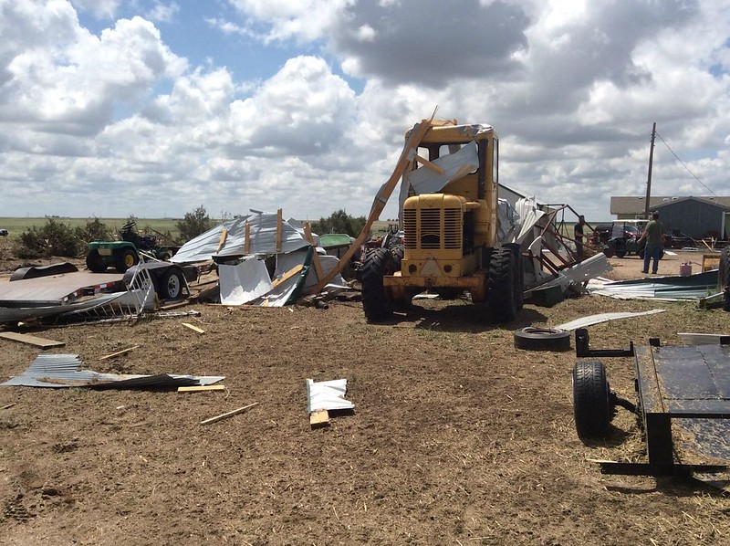
The thunder rolled across eastern Colorado on Tuesday, May 24 – as did hail, wind and tornadoes. Washington County saw the most intense activity with multiple twisters including one damaging tornado that has been rated an EF-1.
The National Weather Service sent survey teams to the area to evaluate the damage inflicted by Mother Nature.
They found two tornadoes of relatively weak EF-0 strength occurred near Akron. Neither any caused damage.
Near Platner though, a more powerful tornado ripped through a farm at about 6:50pm that evening. The twister lifted a pole barn, destroying it. Debris was found one mile away.
Wind and hail ripped across an area six miles wide near Akron causing extensive damage. Farm equipment was toppled and a barn heavily damaged by the wind while houses saw the siding punctured and windows broken from hail.
Below are images taken by the National Weather Service of the area.
| [flickr_set id=”72157668536532282″] |
Public Information Statement
National Weather Service Denver/Boulder CO
1056 AM MDT THU MAY 26 2016

...NWS DAMAGE SURVEY FOR 05/24/16 TORNADO EVENT...

.OVERVIEW...A long-lived supercell thunderstorm moved across
eastern Colorado and produced two EF-1 tornadoes and two EF-0
tornadoes in Washington County on May 24, 2016. Widespread wind
and hail damage also occurred, with a swath of damage nearly 6
miles wide at some points east and northeast of Akron.

.Washington County tornado near Platner...

Rating:                 EF-1
Estimated peak wind:    86-110 mph
Path length /Statute/:  0.9 miles
Path width /Maximum/:   20 yards
Fatalities:             0
Injuries:               0

Start date:             May 24 2016
Start time:             650 PM MDT
Start location:         1 mile northeast of Platner / Washington County / CO
Start Lat/Lon:          40.1647 / -103.0467

End date:               May 24 2016
End time:               655 PM MDT
End location:           1 mile east of Platner / Washington County / CO
End_lat/lon:            40.155 / -103.0366

This tornado struck one farm, lofting and completely destroying
a pole shed, and also damaging trees. Power lines were snapped
just to the southeast of the farm.

.Washington County tornado near Yuma County line...

Rating:                 EF-1
Estimated peak wind:    110 mph
Path length /Statute/:  0.1 mile
Path width /Maximum/:   90 yards
Fatalities:             0
Injuries:               0

Start date:             May 24 2016
Start time:             715 PM MDT
Start location:         9 miles north/northwest of Yuma / Washington County / CO
Start Lat/Lon:          40.2350 / -102.7943

End date:               May 24 2016
End time:               716 PM MDT
End location:           9 miles north/northwest of Yuma / Washington County / CO
End_lat/lon:            40.2348 / -102.7936

This tornado struck one farm, destroying a pole shed. Slight roof damage
occurred to the house, along with some tree damage.

.Washington County tornado 1 mile Northeast of Akron...

Rating:                 EF-0
Estimated peak wind:    65-85 mph
Path length /Statute/:  0.0 miles
Path width /Maximum/:   10 yards
Fatalities:             0
Injuries:               0

Start date:             May 24 2016
Start time:             644 PM MDT
Start location:         1 mile southeast of Akron / Washington County / CO
Start Lat/Lon:          40.1490 / -103.1981

End date:               May 24 2016
End time:               644 PM MDT
End location:           1 mile southeast of Akron / Washington County / CO
End_lat/lon:            40.1490 / -103.1981

Brief touchdown with no damage.

.Washington County tornado 1 mile Southeast of Akron...

Rating:                 EF-0
Estimated peak wind:    65-85 mph
Path length /Statute/:  0.0 miles
Path width /Maximum/:   10 yards
Fatalities:             0
Injuries:               0

Start date:             May 24 2016
Start time:             647 PM MDT
Start location:         1 mile northeast of Akron / Washington County / CO
Start Lat/Lon:          40.1708 / -103.1959

End date:               May 24 2016
End time:               647 PM MDT
End location:           1 mile northeast of Akron / Washington County / CO
End_lat/lon:            40.1708 / -103.1959

Brief touchdown with no damage.

EF Scale: The Enhanced Fujita Scale Classifies
Tornadoes into the following categories.

EF0...Weak...... 65 to 85 mph
EF1...Weak...... 86 to 110 mph
EF2...Strong.... 111 to 135 mph
EF3...Strong.... 136 to 165 mph
EF4...Violent... 166 To 200 mph
EF5...Violent... >200 mph*

NOTE:
The information in this statement is PRELIMINARY and subject to
change pending final review of the events and publication in
NWS Storm Data.
May 7, 2016 Eastern Colorado tornadoes rated at EF-2s
 Severe weather struck the plains of Colorado on Saturday spawning multiple tornadoes. The two most powerful of these, one near Wiggins and another near Wray, have been rated EF-2s on the Enhanced Fujita Scale.
Damage and injuries from both twisters were relatively light, certainly not as bad as they could have been.
The tornado west of Wiggins crossed I-76 and traveled nearly 9 miles reaching 3/4 of a mile wide at one point. It ripped through a private campground at Empire Reservoir damaging and destroying multiple RVs. There were some minor injuries with the storm.
Further east, near Wray, multiple tornadoes were reported, the most significant of which damaged three residences and businesses near the town’s borders. It traveled about 8 miles and at its widest was 440 yards across.
Three other tornadoes were confirmed near Wray although they caused no damage and were rated EF-0s.
Below is some amazing video of the tornado near Wray. Scroll below that for the detailed damage survey from the National Weather Service.
PUBLIC INFORMATION STATEMENT
NATIONAL WEATHER SERVICE DENVER/BOULDER CO
314 PM MDT MON MAY 9 2016

...NWS DAMAGE SURVEY FOR 05/07/16 TORNADO EVENT ACROSS MORGAN
AND WELD COUNTIES - UPDATE # 1...

.UPDATE...ADDING ADDITIONAL TORNADOES.

.OVERVIEW...A TORNADO DEVELOPED JUST SOUTH OF INTERSTATE 76 OVER
WELD COUNTY AND THEN MOVE NORTH ACROSS EMPIRE RESERVOIR BEFORE
LIFTING 2 MILES NORTHWEST OF ORCHARD IN MORGAN COUNTY.  THERE WERE
TWO MINOR INJURIES WHEN A CAMPER WAS ROLLED OVER.  IN ADDITION SEVERAL
CAMPERS WERE DESTROYED AT EMPIRE RESERVOIR.

.TORNADO # 1

RATING: EF-2
ESTIMATED PEAK WIND: 115-120 MPH
PATH LENGTH /STATUTE/: 8.8 MILES
PATH WIDTH /MAXIMUM/:  1320 YARDS
FATALITIES: 0 INJURIES: 2

START DATE:             MAY_07_2016
START TIME:             255 PM_MDT
START LOCATION:         5 WEST OF WIGGINS/WELD COUNTY


END DATE:               MAY_07_2016
END TIME:               310 PM_MDT
END LOCATION:           2 NORTHWEST OF ORCHARD/MORGAN COUNTY


SURVEY_SUMMARY:  MOST OF THE DAMAGE WAS EF0 TO EF1 HOWEVER THERE
WERE A FEW AREAS OF EF2.  THE TORNADO WAS LARGE AND 3/4 OF A
MILE WIDE AT ITS PEAK.

.TORNADO # 2...

RATING:                 EF-0
ESTIMATED PEAK WIND:    85 MPH
PATH LENGTH /STATUTE/:  0.5 MILES
PATH WIDTH /MAXIMUM/:   50 YARDS
FATALITIES:             0
INJURIES:               0

START DATE:             MAY_07_2016
START TIME:             315 PM_MDT
START LOCATION:         6 NORTH OF ORCHARD/MORGAN COUNTY

END DATE:               MAY_07_2016
END TIME:               316 PM_MDT
END LOCATION:           7 NORTH OF ORCHARD/MORGAN COUNTY


.TORNADO # 3...

RATING:                 EF-0
ESTIMATED PEAK WIND:    85 MPH
PATH LENGTH /STATUTE/:  0.5 MILES
PATH WIDTH /MAXIMUM/:   50 YARDS
FATALITIES:             0
INJURIES:               0

START DATE:             05_07_2016
START TIME:             325 PM_MDT
START LOCATION:         14 SOUTHWEST NEW RAYMER/WELD COUNTY

END DATE:               05_07_2016
END TIME:               326 PM_MDT
END LOCATION:           13 SOUTHWEST NEW RAYMER/WELD COUNTY


.TORNADO # 4...

RATING:                 EF-0
ESTIMATED PEAK WIND:    85 MPH
PATH LENGTH /STATUTE/:  0.5 MILES
PATH WIDTH /MAXIMUM/:   50 YARDS
FATALITIES:             0
INJURIES:               0

START DATE:             05_07_2016
START TIME:             335 PM_MDT
START LOCATION:         7 NORTHWEST FORT MORGAN/MORGAN COUNTY

END DATE:               05/07/2016
END TIME:               336 PM_MDT
END LOCATION:           8 NORTHWEST FORT MORGAN/MORGAN COUNTY

PUBLIC INFORMATION STATEMENT
NATIONAL WEATHER SERVICE GOODLAND KS
500 PM MDT SUN MAY 8 2016 /600 PM CDT SUN MAY 8 2016/

THIS INFORMATION IS PRELIMINARY AND SUBJECT TO CHANGE PENDING
FURTHER REVIEW OF DOPPLER RADAR, STORM SPOTTER REPORTS AND STORM
VIDEOS, WHICH ARE STILL ARRIVING INTO THE OFFICE.

...NWS DAMAGE SURVEY FOR 05/07/2016 TORNADO EVENT...

.TORNADO #1...

RATING:                 EF-2
ESTIMATED PEAK WIND:    130 MPH
PATH LENGTH /STATUTE/:  8 MILES
PATH WIDTH /MAXIMUM/:   440 YARDS
FATALITIES:             0
INJURIES:               0

START DATE:             MAY 07 2016
START TIME:             551 PM MDT
START LOCATION:         2 N WRAY

END DATE:               MAY 07 2016
END TIME:               616 PM MDT
END LOCATION:           10 NNE WRAY

TORNADO PATH WAS ONLY SURVEYED BETWEEN 2 AND 5 MILES NORTH OF
WRAY ALONG AND JUST EAST OF HIGHWAY 385. TORNADO LIKELY CONTINUED
WELL NORTH-NORTHEAST OF WRAY BUT LACK OF ROADS PREVENTED FURTHER
SURVEY. THREE RESIDENCES AND TWO BUSINESSES NORTH OF WRAY WERE
IMPACTED...MAJORITY OF TRACK WAS OVER OPEN COUNTRY.


.TORNADO #2...

RATING: EF-0
ESTIMATED PEAK WIND:    85 MPH
PATH LENGTH /STATUTE/:  0.5 MILES
PATH WIDTH /MAXIMUM/:   25 YARDS
FATALITIES:             0
INJURIES:               0

START DATE:             MAY 07 2016
START TIME:             410 PM MDT
START LOCATION:         4 N HEARTSTRONG

END DATE:               MAY 07 2016
END TIME:               411 PM MDT
END LOCATION:           5 N HEARTSTRONG


.TORNADO #3...

RATING:                 EF-0
ESTIMATED PEAK WIND:    85 MPH
PATH LENGTH /STATUTE/:  3 MILES
PATH WIDTH /MAXIMUM/:   50 YARDS
FATALITIES:             0
INJURIES:               0

START DATE:             MAY 07 2016
START TIME:             454 PM MDT
START LOCATION:         4 N ECKLEY

END DATE:               MAY 07 2016
END TIME:               458 PM MDT
END LOCATION:           7 N ECKLEY


.TORNADO #4...

RATING:                 EF-0
ESTIMATED PEAK WIND:    85 MPH
PATH LENGTH /STATUTE/:  1 MILE
PATH WIDTH /MAXIMUM/:   50 YARDS
FATALITIES:             0
INJURIES:               0

START DATE:             MAY 07 2016
START TIME:             539 PM MDT
START LOCATION:         3 S WRAY

END DATE:               MAY 07 2016
END TIME:               541 PM MDT
END LOCATION:           2 S WRAY

THE ENHANCED FUJITA SCALE CLASSIFIES
TORNADOES INTO THE FOLLOWING CATEGORIES.

EF0...WEAK......65 TO 85 MPH
EF1...WEAK......86 TO 110 MPH
EF2...STRONG....111 TO 135 MPH
EF3...STRONG....136 TO 165 MPH
EF4...VIOLENT...166 TO 200 MPH
EF5...VIOLENT...>200 MPH

NOTE:
THE INFORMATION IN THIS STATEMENT IS PRELIMINARY AND SUBJECT TO
CHANGE PENDING FINAL REVIEW OF THE EVENTS AND PUBLICATION IN
NWS STORM DATA.
Several dead as US south and east lashed by storms and tornadoes
|
The US southeast and mid-Atlantic region have been lashed by violent thunderstorms and tornadoes that killed several people. The states of Louisiana, Mississippi, North and South Carolina, Georgia and Virginia were among the worst hit. In Convent, Louisiana, a tornado ravaged a caravan park, killing two people and injuring about 30 others. The town of Waverley… Continue reading Several dead as US south and east lashed by storms and tornadoes |
Texas tornado’s winds topped 200 mph; 11 dead in storms
|
A tornado that blew through Garland, Texas, killing eight people Saturday night has been classified as an EF4, with winds up to 200 mph. It was one of two confirmed tornadoes that tore through North Texas in a storm that killed 11 people, including an infant. The National Weather Service confirmed that the tornado that touched… Continue reading Texas tornado’s winds topped 200 mph; 11 dead in storms |
Aurora, Colorado tornado rated EF-1
The National Weather Service completed an assessment of the damage caused during yesterday’s severe weather in the Denver metro area. They determined that a tornado did indeed touch down and was responsible for the bulk of the damage in Aurora.
The service said the twister was on the ground for 2.8 miles as it passed through Aurora. It however was not a wide tornado only reaching a maximum of 50 yards. Maximum winds were estimated at 86 to 90 mph giving it an EF-1 rating.
The complete text from the National Weather Service statement follows:
NOUS45 KBOU 251829 CCA
PNSBOU
COZ030>051-260600-

PUBLIC INFORMATION STATEMENT...CORRECTED ENDING TIME
NATIONAL WEATHER SERVICE DENVER, CO
1148 AM MDT THU JUN 25 2015

...NWS DAMAGE SURVEY FOR 06/24/2015 TORNADO EVENT...

.EAST DENVER/WEST AURORA TORNADO...

RATING:                 EF-1
ESTIMATED PEAK WIND:    86-90 MPH
PATH LENGTH /STATUTE/:  2.8 MILES
PATH WIDTH /MAXIMUM/:   50 YARDS
FATALITIES:             0
INJURIES:               0

START DATE:             06-24-2015
START TIME:             4:48 PM
START LOCATION:         39.724808/-104.900896

END DATE:               06-24-2015
END TIME:               5:10 PM
END LOCATION:           39.736784/-104.851191

ON WEDNESDAY, JUNE 24TH BETWEEN 4:48PM AND 5:10 PM, A TORNADO
TOUCHED DOWN IN EAST DENVER AND WEST AURORA. THE TORNADO FIRST
TOUCHED DOWN NEAR QUEBEC AND 6TH AVE. IT THEN MOVED EAST-NORTHEAST
ACROSS THE LOWRY CAMPUS INTO THE WEST PART OF AURORA. THE TORNADO
THEN LIFTED NEAR MOUNT NEBO MEMORIAL PARK. BASED ON TREE DAMAGE
THERE WAS LOW END EF1 WITH WIND SPEEDS ESTIMATED IN THE 86-90 MPH
RANGE. MOST OF THE DAMAGE CAUSED BY THE TORNADO WAS IN THE EF0
RANGE.SOME HOMES HAD MINOR ROOF DAMAGE WITH ONE FORMER APARTMENT
BUILDING ON THE LOWRY CAMPUS HAVING SOME HIGHER END ROOF DAMAGE WITH
ESTIMATED WIND SPEEDS IN THE 86-90 MPH RANGE.THE TORNADO PATH
LENGTH BASED ON DAMAGE POINTS WAS 2.8 MILES AND THE WIDTH WAS LESS
THAN 50 YARDS.

EF SCALE: THE ENHANCED FUJITA SCALE CLASSIFIES
TORNADOES INTO THE FOLLOWING CATEGORIES.

EF0...WEAK...... 65 TO 85 MPH
EF1...WEAK...... 86 TO 110 MPH
EF2...STRONG.... 111 TO 135 MPH
EF3...STRONG.... 136 TO 165 MPH
EF4...VIOLENT... 166 TO 200 MPH
EF5...VIOLENT... >200 MPH

NOTE:
THE INFORMATION IN THIS STATEMENT IS PRELIMINARY AND SUBJECT TO
CHANGE PENDING FINAL REVIEW OF THE EVENT AND PUBLICATION IN
NWS STORM DATA.
Video: Russian driver pulls out of garage to find self in midst of F3 tornado
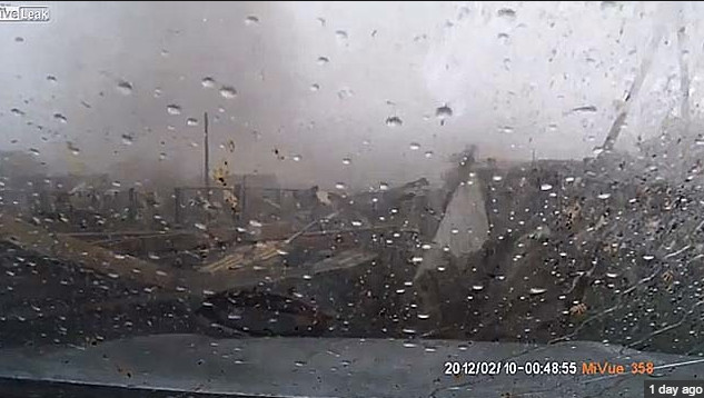
An amazing tornado video captured by a dash mounted camera was released on YouTube recently. Apparently taken in Russia on August 29, a surprised driver pulls out of his garage to discover a tornado ripping through the area.
The video begins with the driver backing out of the driveway in heavy rain. As the vehicle turns to face down the road, trees are being pummeled by strong winds and debris from other houses and nearby buildings flies through the air.
After sitting for a scant few seconds – likely struggling to comprehend Mother Nature’s fury that is erupting around him – the driver tries to go back to his garage. As he turns back, the garage collapses before his eyes.
Video added at the end shows extensive damage to cars and homes in the area.
It is believed the video is of an EF-3 rated twister that tore a 28 mile path through Kariyevo.
Two tornadoes touch down in north Denver metro area, minor damage seen
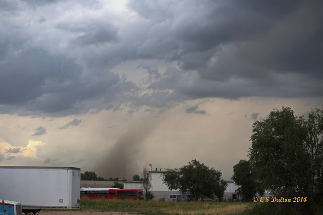
Monday’s forecast called for a chance for thunderstorms but Mother Nature threw in a couple of wildcards in the form of two tornadoes in the area. The landspout tornadoes caused minor damage in north Denver and were widely seen across much of the area.
The first tornado was reported at 3:53pm just across the Adams County line in Weld County near Fort Lupton. The twister was the better defined of the two but appears to have struck farmland with no damage reported.
- Videos: Watch amazing footage of the Weld County tornado below
- In pictures: July photo slideshow has numerous pictures of the tornadoes
At 4:09pm a second tornado was reported near the Rocky Mountain Arsenal National Wildlife Refuge in Adams County. A diesel repair shop near 51st and Havana had one of its garage doors ripped off and some material thrown about.
Denver International Airport sent travelers to shelters for a period of time and warning sirens were sounded in Brighton, Commerce City and other nearby locations.
Three people on a small boat on Barr Lake were overturned by the strong thunderstorm winds. The trio managed to swim to shore and were not injured.
Tuesday’s weather is not expected to contain quite as much excitement as yesterday’s. However, heavy rain will be possible and a Flash Flood Watch has been issued.
Video captures twin EF-4 tornadoes in Nebraska

Severe weather struck eastern Nebraska on June 16 spawning an amazing four EF-4 rated tornadoes in less than an hour. Two of these were twins, formed from the same supercell thunderstorm at nearly the same time, and stunning video from a resident’s porch shows the beasts.
While this event and the video are a few weeks old, it is well worth sharing. The imagery is a stunning display of Mother Nature’s most violent phenomena.
Timothy Klaustermeier took the video and posted it to YouTube. The nearly seven minute long video shows both tornadoes that spawned near Pilger and lifted north of Wisner. Amazingly the man appears to have been quite calm during the event as the only sounds heard are the roaring of the twisters.
The National Weather Service rated both of these tornadoes as EF4s on the Enhanced Fujita Scale which means they were packing winds of at least 166mph. One traveled over 18 miles, the other nearly 12 miles.
Two other twisters in the same area, one just before and one just after the twins, were also rated EF4s.
Extensive damage was seen in the areas of Pilger and Wisner. Two fatalities were recorded: A five year old girl and a 75 year old man. Sixteen people were critically injured in the storms.
A look back at the most destructive tornado in Denver metro history: June 3, 1981 Thornton, Colorado
")
June 3, 1981 appeared to be a pretty typical late spring day in the Denver metro area. Afternoon thunderstorms though would become a ‘perfect storm’ and soon the city of Thornton would find itself witness to a tornado that would go down in the Denver weather history books.
Five tornadoes would strike that day but one would become the most infamous. The Thornton tornado would tear through what was then the heart of the city damaging homes and businesses and sending many residents to the hospital.
The twister initially touched down at 2:43 p.m. and ripped across 2 miles of the city. The tornado was rated an F2 on the Fujita Scale packing winds up to 157mph.
Following is a description of the event from the National Weather Service and below that is a slideshow of some photos of the event we have accumulated.
In 1981…severe thunderstorms produced tornadoes over metro Denver. The first tornado touched down at the intersection of Alameda Ave. And Sheridan Blvd. The twister moved north along Sheridan Blvd….damaging businesses…apartment buildings…homes…and vehicles. Over ten homes were unroofed. The roof of one landed in the middle of a neighborhood park. At least 10 mobile homes were wrecked.
The tornado curved to the northeast into northwest Denver… Hopping up and down in several places. Very strong winds outside the actual funnel caused 20 to 30 thousand dollars in damage in downtown Denver. The third floor of one old building was demolished. No major injuries were reported from the tornado…although several people were hurt slightly in traffic accidents on Sheridan Blvd. in the confusion caused by the storm. Damage in Lakewood alone was estimated at 200 thousand dollars.
At the same time… The worst tornado to ever hit metro Denver struck Thornton. Coming from the same thunderstorm that spawned the Denver twister…the Thornton tornado tore a swath through the heart of the city. 87 homes were destroyed…110 others damaged at least moderately. In all…600 homes in a 100 block area sustained some damage. The twister also hit shopping centers…several restaurants…and other buildings. Seven of the 42 injured were considered serious. The storm was strong enough to snap lamp posts in half and drive a 6- inch slab of wood 2 feet into the ground. Damage was estimated at up to 50 million dollars.
The same storm that struck Thornton produced another damaging tornado that touched down in the northwest section of Fort Lupton. This twister damaged 16 homes and numerous cars and campers. Two children were slightly injured when the car they were in was knocked about and its windows shattered by the storm. The twister also damaged two commercial buildings. Damage was very spotty…and observers said the storm hopped up and down at least 3 times. Dollar damage was estimated at 500 thousand dollars.
The thunderstorm complex that produced 3 damaging tornadoes also dropped large hail which damaged many cars over northwest Denver. One to 2 inches of rain fell in less than an hour…flooding a mobile home park with 3 to 4 feet of water on the northwest edge of Denver. The high water damaged about half of the 392 homes in the park. Local flooding was also reported in other areas across metro Denver. A tornado was also sighted near Franktown…but caused no damage. A thunderstorm wind gust to 52 mph was recorded at Stapleton International Airport.
Also see:
- New York Times, June 4, 1981: At Least 40 in Denver Area Are Injured by Tornadoes
- Northglenn-Thornton Sentinel – June 26, 2008 – Off the top
- American Meteorological Society: A Subsynoptic Analysis of the Denver Tornadoes of 3 June 1981
- NCAR: June 26, 1981 press release about the Thornton tornado


|