Tag Archives: October weather

October 2022 top shots: Monthly photo slideshow

A trail of golden aspen in the Colorado high country. (Patrick Martin Photography)

October in Thornton can bring a wide variety of weather conditions, perfect for the photographer in all of us.

The month brings the changing of the colors at Colorado’s lower elevations and it is also is typically when we see our first freeze and first snow.

Couple those facts with our usual widely varying landscapes and wildlife and we have a month that is sure to bring in plenty of photo opportunities.

  • Slideshow updated October 28, 2022
  • To learn more about how to send your photo to us for inclusion in the slideshow, see below the slideshow.

Showcasing images captured by ThorntonWeather.com readers as well as some of our own, our monthly slideshow covers the entire gamut of weather-related imagery.

Sunsets, sunrises, wildlife and of course every type of weather condition are vividly depicted in images captured from yours and our cameras.

[flickr_set id=”72177720302849011″]

What is missing in the slideshow above?  Your photo!

Our monthly photo slideshow is going to feature images that we have taken but more importantly images that you have captured.  The photos can be of anything even remotely weather-related.

Landscapes, current conditions, wildlife, pets, kids.  Whimsical, newsy, artsy.  Taken at the zoo, some other area attraction, a local park, a national park or your backyard.  You name it, we want to see and share it!

Images can be taken in Thornton, Denver or anywhere across the extraordinary Centennial State.  We’ll even take some from out of state if we can tie it to Colorado somehow.

We’ll keep the criteria very open to interpretation with just about any image eligible to be shown in our slideshows.

What do you win for having your image in our slideshow?  We are just a ‘mom and pop’ outfit and make no money from our site so we really don’t have the means to provide prizes.  However you will have our undying gratitude and the satisfaction that your images are shared on the most popular website in Thornton.

To share you images with us and get them included in the slideshow just email them to us or share them with ThorntonWeather.com on any of the various social media outlets.  Links are provided below.

So come on, get those camera’s rolling!

October 23 to October 29: This Week in Denver Weather History

This Week in Denver Weather History

It’s not quite Halloween but leading up to the holiday we see plenty of  ‘scary’ weather in our look back at this week in Denver weather history. High winds are relatively commonplace and so too are major snowstorms. One recent event in 1997 dumped 14 to 31 inches of the white stuff on the metro area.

From the National Weather Service:

18-23

In 2003…an extended warm spell resulted in 5 new temperature records. The high temperature of 84 degrees on the 18th equaled the record high for the date. High temperatures of 86 degrees on the 19th…83 degrees on the 21st…and 84 degrees on the 22nd were record highs for the dates. Low temperature of 49 degrees on the 23rd was a record high minimum for the date. Low temperatures during the period were in the 40’s and lower 50’s.

19-23

In 1906…heavy snowfall totaled 22.7 inches in the city over the 5 days. Rain changed to snow on the evening of the 19th…and snow continued through the late afternoon of the 23rd. The heaviest amount of snowfall…16.0 inches…fell from 8:00 pm on the 20th to 8:00 pm on the 22nd. The most snow on the ground was 13.3 inches on the evening of the 23rd. This was the first snow of the season and the only snow of the month. Winds during the storm were from the north at sustained speeds of 20 to 30 mph each day. Temperatures during the storm were generally in the 20’s.

22-23

In 1914…post-frontal rain changed to snow. Precipitation totaled 2.72 inches…most of which was in the form of moist snow which melted as it fell in the business section of the city. About 3 inches of snow was measured on lawns in the residential areas on the morning of the 24th. Official snowfall totaled only 0.4 inch downtown… But an estimated 8.0 inches of snow melted as it fell. North to northeast winds were sustained to 29 mph with gusts to 30 mph on both days.

In 1975…a vigorous cold front moving across metro Denver followed by strong northeast winds gusting to 52 mph produced billows of blowing dust and plunged the temperature 21 degrees in an hour. The surface visibility was reduced to 1/4 mile in blowing dust at Stapleton International Airport. The temperature cooled from a daily record high of 81 degrees to a low of 38 degrees by day’s end. The first snowfall of the season totaled 2.7 inches on the 23rd. This was the only measurable snow of the month at Stapleton International Airport.

In 1995…heavy snow fell on the Palmer Ridge south of Denver and in the foothills west of Denver where snow amounts ranged from 4 to 8 inches. Sedalia…south of Denver… Received 8 inches of snow. Winds strengthened on the plains and produced blizzard conditions…reducing surface visibilities to less than 1/4 mile. I-70 was closed from just east of Denver at Gun Club Road to the Kansas border. Ten inches of snow fell at Strasburg east of Denver where north winds at sustained speeds of 35 to 45 mph with gusts as high as 60 mph produced 2 to 4 foot drifts. Snowfall totaled only 2.2 inches at the site of the former Stapleton International Airport. North winds gusted to 51 mph at Denver International Airport.

23

In 1876…skies were fair…but winds were sustained to 48 mph.

In 1942…a major storm dumped 10.2 inches of snow over downtown Denver. Post-frontal northeast winds were sustained to only 13 mph.

In 1955…the first snowfall of the season and the only measurable snow of the month dumped 4.1 inches of snow on Stapleton Airport. This was the single heaviest October snowfall in 13 years since 1942. The storm also brought the first sub-freezing temperatures of the season when the temperature dipped to a low of 25 degrees.

In 1956…southwest winds gusted to 53 mph and produced some blowing dust at Stapleton Airport.

In 1967…a northwest wind gust to 51 mph was recorded at Stapleton International Airport. In downtown Boulder… Winds were sustained at 20 mph with gusts in excess of 40 mph.

In 1981…strong winds occurred in the foothills. Wind gusts to 70 mph were reported at Wondervu.

23-24

In 1887…the first measurable snowfall of the season totaled 3.1 inches. North winds to 20 mph were recorded on the 23rd. This was the only measurable snow of the month.

In 1932…post-frontal snowfall from the late evening of the 23rd continued through the late afternoon of the 24th and totaled 6.2 inches. Southeast winds were sustained to 25 mph with gusts to 26 mph on the 23rd. Temperatures cooled from a high of 68 degrees on the 23rd to a low of 25 degrees on the 24th…the coldest reading of the month that year. Many trees that had not shed their leaves became heavily laden by the wet snow. Many branches were broken… And a few trees toppled under the weight of the snow. The landscape became one of rare beauty.

23-25

In 2021…after several weeks of warm…windy and dry weather that fueled the two largest wildfires in the state`s history; a powerful storm system brought welcome relief as it produced heavy snow and frigid temperatures Denver and the Front Range. In the Front Range mountains and foothills… storm totals ranged from 10 to 20 inches. Along the urban corridor…storm totals from 4 to 12 inches were observed… with the heaviest amounts along and generally west of I-25 and over Weld County…where localized bands of heavy snow Some storm totals included 14.3 inches near Allenspark; and 12.9 inches in southeast Boulder and Nederland…with 12.8 inches near Loveland. At Denver International Airport…4.0 inches of snowfall was observed.

24

In 1956…southwest winds gusted to 56 mph and produced some blowing dust at Stapleton Airport. A cold front produced a thunderstorm with 1/8 inch hail. Rain later changed to snow. Precipitation totaled only 0.11 inch and snowfall only 0.3 inch.

In 1973…strong winds raked the eastern foothills…causing damage in Boulder and Jefferson counties. The heaviest damage occurred in the Boulder area where 20 to 25 mobile homes were hit…some power and telephone lines were blown down…and a store was damaged. A wind gust to 76 mph was recorded in Boulder at the National Bureau of Standards. Northwest winds gusted to 46 mph at Stapleton International Airport.

24-25

In 1921…rainfall totaled 0.35 inch overnight behind an apparent cold front. North winds were sustained to 40 mph with gusts to 46 mph on the 25th. Temperatures plunged from a high of 73 degrees on the 24th to a low of 39 degrees on the 25th.

In 1923…rain overnight changed to snow during the morning. The heavy snowfall accumulated to 12.0 inches before ending on the morning of the 25th. Post-frontal north winds were sustained to 22 mph with gusts to 23 mph on the 24th.

In 1997…one of the worst and deadliest blizzards of the decade developed over eastern Colorado as deep east to northeast flow associated with a vigorous upper level low pressure system over the Four Corners…combined with a strong arctic air mass over the central great plains. Snowfall totals across metro Denver ranged from 14 to 31 inches. The heaviest snowfall occurred in the foothills west and southwest of Denver where 2 to 4 feet of snow were measured. Sustained winds to 40 mph with gusts as high as 60 mph produced zero visibilities and extremely cold wind chill temperatures from 25 below to 40 below zero. Winds whipped the snow into drifts 4 to 10 feet deep. Several major and interstate highways were closed as travel became impossible. Red Cross shelters were set up for hundreds of travelers who became stranded when they had to abandon their vehicles. Four people died in northeastern Colorado as a result of the blizzard. None of the deaths were in metro Denver. At Denver International Airport…4 thousand travelers were stranded when the airport was forced to shut down. At least 120 cars were abandoned along Pena Blvd….the only arterial leading into and out of dia. The blizzard cost air carriers at least 20 million dollars. Thousands of cattle died in the storm over northeastern Colorado…resulting in losses totaling 1.5 million dollars. Some of the more impressive snowfall totals included: 51 inches at Coal Creek Canyon; 48 inches at Silver Spruce Ranch…near Ward; 42 inches at Intercanyon…in the foothills southwest of Denver; 37 inches at Sedalia; 35 inches at Aspen Springs and Conifer in the foothills west of Denver; 31 inches at Eldorado Springs… Southeast Aurora…and Englewood; and 30 inches on Table Mesa in Boulder. Snowfall totaled 21.9 inches at the site of the former Stapleton International Airport…setting a new 24-hour snowfall record of 19.1 inches for the month. Snowfall totaled only 14 inches at Denver International Airport where north winds gusted to 39 mph on the 24th. High temperature of only 21 degrees on the 25th equaled the record low maximum for the date first set in 1873. Low temperature of only 3 degrees on the 26th set a new record minimum for the date. Continue reading October 23 to October 29: This Week in Denver Weather History

October 16 to October 22: This Week in Denver Weather History

This Week in Denver Weather History

Snow and wind are two common conditions we see this time of year and our look back at this week in Denver weather history certainly has those type of events. Also notable is a surprising October hail storm 13 years ago that went into the books as one of the costliest in history.

From the National Weather Service:

13-16

In 1873…smoke from several large forest fires in the mountains made the air very hazy in the city.

15-16

In 1928…a thunderstorm produced hail shortly after midnight on the 15th. Rain changed to snow by evening. Through the afternoon of the 16th…the heavy snowfall totaled 7.3 inches in the city. North winds were sustained to 23 mph on the 15th.

In 1984…the heaviest October snowstorm in several years hit eastern Colorado with a vengeance. The storm was known as the “Bronco Blizzard” since it occurred during a nationally televised Monday Night Football game in Denver. One to two feet of snow fell near the foothills in west metro Denver with 2 to 3 feet in the foothills. Wind gusts up to 55 mph whipped the snow into drifts as high as 4 feet. The storm closed schools…roads…and airports. I-70 was closed both east and west of Denver. I-25 was closed south to Colorado Springs. Flights were delayed for several hours at Stapleton International Airport. Power outages were widespread. Snowfall totaled 9.2 inches at Stapleton International Airport where north winds gusting as high as 40 mph caused frequent surface visibilities of 1/4 to 1/2 mile in moderate to heavy snow and blowing snow overnight. The high temperature of only 35 degrees on the 15th was a record low maximum for the date.

15-17

In 1989…an autumn snowstorm hit metro Denver with 2 to 6 inches of snow. Snowfall totaled 4.4 inches at Stapleton International Airport where the maximum snow depth on the ground was only 3 inches due to melting and north winds gusted to 25 mph on the 15th. The heavy wet snow caused leafy branches to sag onto power lines…resulting in a number of power outages. Five thousand homes were blacked out in Boulder on the 16th. Up to a foot of snow fell in the higher foothills with 19 inches recorded at Echo Lake.

16

In 1878…high winds reached sustained speeds of 60 mph.

In 1998…one of the costliest hail storms to ever hit metro Denver caused an estimated total of 87.8 million dollars in damage to homes…commercial buildings…and motor vehicles. At the time the storm was ranked as the 7th costliest ever. The hailstorm…rare for so late in the season…began over portions of Arvada…Wheat Ridge…and northwest Denver where mostly pea sized hail accumulated up to a depth of 6 inches near I-70. Several accidents were attributed… At least in part…to the hailstorm. Snowplows had to be called out to clear several city streets. The storm intensified as it moved to the east…into the Denver and Aurora areas. Large hail…up to 2.00 inches in diameter pounded east and southeast metro Denver. Two inch diameter hail fell in the city of Denver and at Buckley Field. Hail as large as 1 1/2 inches was measured in south Denver with 1 inch diameter hail in northern Aurora.

In 1999…upslope conditions produced snow across metro Denver with heavy amounts in the nearby foothills. Snowfall totals included: 9 inches at Eldorado Springs; 8 inches at Genesee… Golden Gate Canyon…Littleton and near Morrison; 7 inches near Nederland; and 6 inches in Louisville. Snowfall totaled 3.6 inches at the site of the former Stapleton International Airport.

16-17

In 1990…strong downslope winds raked the eastern foothills. Wind gusts from 60 to 75 mph were common. Strong winds in metro Denver resulted in wave damage to a dock used to moor several private sail boats at Cheery Creek Reservoir. Damage was confined to the dock and two anchor cables. A northwest wind gust to 43 mph was recorded at Stapleton International Airport.

17

In 1878…strong winds reached sustained speeds of 48 mph.

In 1988…a wind gust to 62 mph was recorded in central Boulder. The strong winds caused a few brief power outages. An old smoldering brush fire in the foothills west of Boulder was re-ignited by the wind gusts.

In 1994…winds gusted to 85 mph atop Squaw Mountain…5 miles south of Idaho Springs.

In 2006…a potent storm system brought heavy snowfall to the mountains and eastern foothills. Snowfall totals in the foothills included: 14 inches at Blackhawk…13.5 inches near Idaho Springs…13 inches at cabin creek…12.5 inches at Aspen Springs and Echo Lake…11.5 inches at Georgetown and Rollinsville…10.5 inches near Jamestown…and 10 inches at grant and Lake Eldora. Lesser snow amounts…from 4 to 9 inches…were recorded elsewhere in the foothills. Snowfall totaled only 3.5 inches in the Denver Stapleton area. At Denver International Airport…north winds gusted to 31 mph.

In 2012…A brief but powerful windstorm associated with a fast moving cold front across the Urban Corridor and adjacent plains during in the evening. Peak wind gusts ranging from 58 to 71 mph downed trees and power lines which damaged homes and vehicles. Several temporary structures were also damaged. Approximately fifty thousand were left without power in the Denver…Fort Collins and Greeley areas. Some schools were closed the following day until power could be restored. Around the Denver area…peak wind gusts included: 69 mph in Golden…64 mph at Littleton…62 mph at Buckley AFB and in Denver…near the intersection of Walnut St. and Interstate 25…and Longmont; 59 mph at Centennial Airport…58 mph at Denver City Park… Highlands Ranch.  At Denver International Airport…a peak wind gust to 35 mph was observed from the northwest.

17-19

In 1908…a moist…heavy…wet snowfall totaled 13.0 inches in downtown Denver over the 3 days. Rain from early morning on the 17th changed to snow by late afternoon and continued through the late morning of the 19th. Due to temperatures in the 30’s and melting…the most snow on the ground was only 5.0 inches at 6:00 pm on the 18th. Northwest to northeast winds were sustained between 12 and 20 mph during the storm. Precipitation totaled 1.82 inches.

18

In 1875…the haze was so dense that the mountains were not visible from downtown Denver for most of the day.

In 1937…a vigorous cold front produced north winds sustained to 32 mph with gusts to 41 mph. Rain and snow totaled 0.16 inch. Post-frontal snowfall of 0.8 inch was the only snowfall of the month.

In 1960…post-frontal upslope rain changed to snow. Snowfall was 2.2 inches at Stapleton Airport where precipitation (rain and melted snow) totaled 1.58 inches.

In 1971…wind gusts to 48 mph were recorded in downtown Boulder. West winds gusted to 30 mph at Stapleton International Airport.

In 1999…heavy snow developed in the foothills west of metro Denver with lesser amounts across the city. Snowfall totals included: 7 inches near Nederland…6 inches in Boulder…and 5 inches at Chief Hosa. Only 1.2 inches of snow were measured at the site of the former Stapleton International Airport.

18-23

In 2003…an extended warm spell resulted in 5 new temperature records. The high temperature of 84 degrees on the 18th equaled the record high for the date. High temperatures of 86 degrees on the 19th…83 degrees on the 21st…and 84 degrees on the 22nd were record highs for the dates. Low temperature of 49 degrees on the 23rd was a record high minimum for the date. Low temperatures during the period were in the 40’s and lower 50’s.

19

In 1887…northwest winds sustained to 42 mph were recorded in the city.

In 1982…3 to 6 inches of snow fell over northwest metro Denver…including Boulder. Only 1.2 inches of snowfall were recorded at Stapleton International Airport where north winds gusted to 35 mph. This was the first measurable snowfall of the season.

19-20

In 1990…an early winter storm dumped heavy snow across metro Denver. Snowfall amounts ranged from 4 to 8 inches in the foothills above 6500 feet elevation…4 to 7 inches in the Castle Rock area…and 2 to 5 inches across most of metro Denver and Boulder. Snowfall totaled 3.6 inches at Stapleton International Airport where northwest winds gusting to 48 mph kicked up some blowing dust shortly after a cold frontal passage on the 19th. However… Temperatures were warm enough to keep most roadways wet and slushy at lower elevations.

19-23

In 1906…heavy snowfall totaled 22.7 inches in the city over the 5 days. Rain changed to snow on the evening of the 19th…and snow continued through the late afternoon of the 23rd. The heaviest amount of snowfall…16.0 inches…fell from 8:00 pm on the 20th to 8:00 pm on the 22nd. The most snow on the ground was 13.3 inches on the evening of the 23rd. This was the first snow of the season and the only snow of the month. Winds during the storm were from the north at sustained speeds of 20 to 30 mph each day. Temperatures during the storm were generally in the 20’s. Continue reading October 16 to October 22: This Week in Denver Weather History

October 9 to October 15: This Week in Denver Weather History

This Week in Denver Weather History

Denver has yet to get a taste of wintry weather this year as we continue what has been a very dry period the last few months. In the past that hasn’t always been the case and our look back at this week in Denver weather history shows that heavy, winter-like snowstorms can and do strike in October.

From the National Weather Service:

8-9

In 2017…an early season snowstorm produced heavy wet snow which broke branches and downed power lines. About ninety- eight thousand outages occurred in Denver and the surrounding metro area. Almost half the outages were very short…while 54210 were sustained outages that lasted longer than five minutes. Some however lasted for several hours. Snow amounts varied greatly along the Interstate 25 Corridor. West of I-25…storm totals included: 7.5 inches in Arvada…7 inches in Broomfield…6 inches Boulder and Louisville…with 5 inches at Ralston Reservoir. East of I-25…storm totals ranged from a trace to 4 inches. In the mountains and foothills…storm totals included: 12.5 inches near Genesee…10 inches at Eldorado Springs… Idledale and Nederland…with 8.5 inches near Jamestown.

9

In 1910…light smoke from forest fires in the mountains was sighted over the city.

In 1982…northwest winds gusted to 49 mph at Stapleton International Airport.

9-10

In 2005…a major winter storm brought heavy…wet snowfall to the Front Range mountains…eastern foothills…portions of metro Denver…and the Palmer Divide. Snow accumulations ranged from 8 to 26 inches with drifts from 3 to 4 feet in places. The heaviest snow occurred to the east and southeast of the city…closing most major highways in that area…including I-70 from Denver to Limon. The Red Cross opened four shelters for people who were stranded along I-70 in eastern Colorado. Since many trees had not yet shed their leaves…the storm caused significant tree damage. One woman in Denver was killed when a tree branch… 8 to 10 inches in diameter…snapped under the weight of the heavy…wet snow and struck her as she was shoveling her driveway. Xcel Energy reported power outages to about 35 thousand customers. Several incoming flights were delayed at Denver International Airport. Snow totals included: 16 inches in the foothills near Boulder…12 inches at Genesee and near Golden…22 inches near Watkins…19 inches near Bennett…17 inches southeast of Aurora…14 inches near Parker…13 inches near Castle Rock…12 inches in centennial… 11 inches in Parker…and 10 inches at Denver International Airport and in Littleton. While many areas of metro Denver received heavy snow…others experienced almost entirely rain. This included west and northwest metro Denver…Boulder…and Longmont. Rainfall amounts were significant as storm totals ranged between 1.50 and 2.50 inches. The steady rainfall triggered 3 rockslides in foothills canyons. Two of the slides occurred on State Highway 119 in Boulder Canyon and the longest slide…7 feet in length…on State Highway 74 in Bear Creek Canyon at Idledale. North winds were sustained to around 23 mph with gusts to 31 mph at Denver International Airport on the 9th. The high temperature of only 34 degrees on the 10th was a record low maximum for the date. The low temperature on both days was 32 degrees.

In 2019…a vigorous winter like storm system brought intense northerly winds and the cold front blasted through the urban corridor. Peak wind gusts from 50 to 60 mph accompanied the front. Some trees in Denver were uprooted by the strong winds. Light rain and drizzle overnight…changed over to the season`s first snow during the predawn hours of the 10th. Bands of moderate to heavy snow brought 2 to 6 inches of snow in the Front Range mountains…foothills and urban corridor. The morning commute was especially hazardous as falling temperatures froze wet roads. Multiple crashes occurred including: I-25 in Denver…I-70 from Denver west to the Eisenhower Tunnel and State Highway 285 towards Fairplay. Over 300 crashes were reported in Denver and Aurora alone. After reaching a maximum temperatures of 83 degrees on the afternoon of the 9th…the temperature plummeted to 13 degrees on the 10th. A temperature change of 70 degrees…the second largest 2-day swing for the month of October in Denver weather history.

10

In 1901…an evening thunderstorm produced east winds to 43 mph with gusts to 48 mph.

In 1949…strong winds believed to be the worst in Boulder’s history at the time caused over 100 thousand dollars damage in the city. Peak winds were estimated to 85 mph at Valmont…just east of Boulder. High winds also occurred over most of metro Denver and caused damage to trees…window glass…and utility lines. The damage was most pronounced over the northwest metro area…including north Denver and Lakewood. Falling tree branches caused damage to parked autos and houses. Wind gusts to 70 mph were recorded at Stapleton Airport.

In 1964…lightning struck and killed a 13-year-old boy…while he was riding his bicycle along a tree-lined residential street in south Denver. Apparent microburst winds gusted to 54 mph at Stapleton International Airport.

10-11

In 1986…the first significant snowstorm of the season produced 2 to 5 inches of snow over metro Denver with 5 to 10 inches in the foothills west of Denver. Wondervu recorded the most snow from the storm…13 inches. The heavy wet snow caused numerous power outages. The storm was accompanied by strong north winds with gusts to 41 mph recorded on the 10th. The first snowfall of the season totaled 3.1 inches at Stapleton International Airport with only one inch on the ground due to melting. The strong cold front accompanying the storm cooled the temperature from a high of 73 degrees on the 10th to a high of only 33 degrees on the 11th…which was a record low maximum for the date.

10-12

In 1969…the second heavy snowstorm in less than a week dumped nearly a foot of snow across metro Denver and plunged the area into extremely cold temperatures for so early in the season. Snowfall totaled 11.0 inches at Stapleton International Airport. North winds gusting to 26 mph produced drifts up to 2 feet deep. Temperatures dipped from a high of 52 degrees on the 10th to a record low for the date of 10 degrees on the 12th. There was additional damage to trees and power and telephone lines from heavy snow accumulations and icing. Travel was restricted or blocked by drifting snow in both the mountains and on the plains east of Denver. Continue reading October 9 to October 15: This Week in Denver Weather History

Leaf peeping 2022: When and where to see the fall colors

Rocky Mountain National Park is a prime spot for viewing the fall foliage. (Tony's Takes)
Rocky Mountain National Park is a prime spot for viewing the fall foliage. (Tony’s Takes)

This time of year many folks start thinking about heading to the hills west of Denver in search of gold – fall foliage gold.

Where to go?  Below are five of ThorntonWeather.com’s favorite ones near Denver – plus a few further out and some bonus ideas.  After that, we will tell you where you can find a great website that provides regular updates on viewing conditions.

I-70 Corridor – If you’re looking for the easiest route, then this one is for you.  Simply head west on I-70 about 110 miles to Avon.  Between Vail and Avon, both sides of I-70 are lined beautifully with aspen.

Rocky Mountain National Park – One of the most popular summer destinations in the state is of course also a prime spot to view aspen in all their glory.  Once in the park head toward Bear Lake.  Glacier Gorge Junction provides a beautiful spot and you of course also get to enjoy all the splendor that Rocky Mountain National Park has to offer.  Extend your viewing by taking Trail Ridge Road all the way through to the west side of the park and the Grand Lake and Granby area.

Peak to Peak Highway – This little road trip can be a dual purpose trip – gambling and fall foliage viewing!  Take U.S. 6 through Clear Creek Canyon and then 119 through Blackhawk and Central City.  You can of course stop there if your wallet is fat enough and donate some money to the casinos.  From there continue on 119 toward Nederland.  Take highway 72 toward Ward and Allenspark.  There you will find more golden aspen than you can imagine, all with the Continental Divide nearby.

Colorado Fall Foliage - Average Date of Peak Aspen Colors. Click for larger view. (ThorntonWeather.com)
Colorado Fall Foliage – Average Date of Peak Aspen Colors. Click for larger view. (ThorntonWeather.com)

Poudre Valley Canyon –  Heading north on I-25 take Colorado 14 west and into Poudre Canyon and Roosevelt National Forest.  As you continue west you will come very near timberline as you come to Cameron Pass.  Amazing views abound!

Guanella Pass – This is a nice, relatively short drive from Denver.  From C470 take 85 through Bailey and Conifer, a nice drive unto itself.  When you come to the town of Grant, take the Guanella Pass Scenic and Historic Byway north to Georgetown.  The air is pretty thin along the way as you climb in excess of 11,500 views through the Pike and Arapahoe National Forests.

A couple other possibilities further from the Front Range:

Leadville / Aspen – From Denver take I-70 west to Copper Mountain and then Colorado 91 south over Freemont Pass to Leadville. Along the way there are plenty of viewing opportunities and Leadville is a nice little town to make a stop. From here you can take Highway 24 north back through Minturn and Vail. To extend the drive, take Highway 24 south to Colorado 82 and head toward Aspen. You can stop by the Maroon Bells in White River National Forest to view some of the most photographed mountains in Colorado.

Cottonwood Pass – From Denver take Highway 285 to Buena Vista. Head west on Main Street for seven miles then west on County Road 344 / Colorado 82. From there you start the climb up Cottonwood Pass with absolutely stunning views from the top. If you are up for it, you can continue down the west side of the pass into the Taylor Park area.

Honorable mentions worth considering:

  • Boreas Pass between Breckenridge and Como (County Road 10)
  • Kenosha Pass on Highway 285 between Bailey and Fairplay
  • Independence Pass (Colorado 82 between Aspen and Twin Lakes)
  • Colorado 103 from Evergreen to Echo Lake. Throw in a drive up Mount Evans for a bonus.

If you do head out, be sure to send us your pictures for inclusion in our monthly photo slideshows!

For more information:

Thornton’s October 2022 preview: Generally calm conditions with our first freeze and snow

Thornton, Colorado October weather preview.
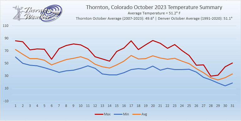
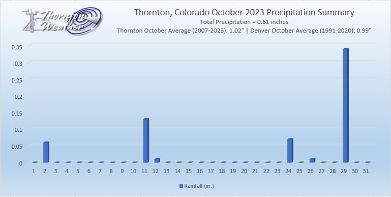
With the first full month of fall here, October usually brings one of the quietest weather months in the Denver area with plenty of mild, sunny days and clear, cool nights.

October is historically the second sunniest month and conditions are generally calm.

However we also will usually see our first taste of winter during the month with the first freeze and first snowfall of the season.  Temperatures as well will start to drop and by the end of the month the average nighttime lows are below freezing.

For complete details on our historical October weather and what we can expect in the coming month, read our complete October weather preview here.

  • Don’t miss a thing when it comes to our ever-changing weather! Be sure to ‘like’ us on Facebook and follow us on Twitter.

October 2 to October 8: This Week in Denver Weather History

This Week in Denver Weather History

October is usually a relatively calm weather month in Denver but can see some interesting events. In our look back at this week in Denver weather history we see tornadoes, damaging wind and of course snow.

From the National Weather Service:

2

In 1903…southwest winds were sustained to 42 mph with gusts as high as 60 mph. The strong Chinook winds warmed the temperature to a high of 78 degrees.

In 1910…an apparent dry microburst produced sustained northeast winds to 43 mph.

In 1934…a trace of rain was the only precipitation of the month. This was the driest October on record.

3

In 1875…very dense haze hid the mountains from view as observed from the city.

In 1933…rainfall of just 0.01 inch was the only precipitation of the month. This was the second driest October on record.

In 1954…the low temperature cooled to only 60 degrees…the all-time record high minimum for the month October.

3-4

In 1969…the first snowfall of the season totaled 16.0 inches at Stapleton International Airport. There was a thunder snow shower on the evening of the 3rd…but otherwise little wind with the storm. The greatest snow depth on the ground was 8 inches due to melting. Heavy wet snow accumulated on trees…which were still in full leaf…and caused widespread damage from broken limbs and downed utility lines.

3-5

In 1984…the remnants of pacific hurricane Polo produced heavy rain over northeastern Colorado. Most locations received between 1.00 to 2.50 inches of rain…but 3.45 inches fell in Littleton. Rainfall totaled 1.73 inches at Stapleton International Airport…where north winds gusted to 24 mph.

4

In 1912…sustained south winds to 55 mph with gusts to 60 mph raised the temperature to a high of 83 degrees… The warmest temperature of the month that year.

In 1924…west winds were sustained to 46 mph with gusts to 50 mph in the city. The apparent Bora winds cooled the temperature to a high of 57 degrees from a high of 70 degrees on the 3rd.

In 2004…several small tornadoes touched down near Brighton… Barr lake…and Hudson in Adams and southern Weld counties. Most of these caused no damage. However…a small tornado 5 miles southeast of Brighton caused extensive damage to a recreational vehicle and severely damaged a barn. The barn was torn from its foundation…and the roof was thrown 100 feet. Four llamas in the barn were injured when it collapsed.

4-5

In 1997…unusually warm weather resulted in two temperature records. High temperature of 87 degrees on the 4th exceeded the old record set in 1922 by one degree. High temperature of 86 degrees on the 5th equaled the record set in 1990 and previous years.

Continue reading October 2 to October 8: This Week in Denver Weather History

September 25 to October 1: This week in Denver weather history

This Week in Denver Weather History

Colorado’s famously inconsistent weather can be seen in our look back at this week in Denver weather history. Not only do we see damaging thunderstorms and winds but even major snowstorms that deposited more than a foot of the white stuff on the city.

From the National Weather Service:

25

In 1873…a fire was sighted in the woods near Platte Canyon… Probably caused by high winds blowing sparks among the timber.

In 1896…an apparent cold front produced northeast sustained winds to 40 mph with gusts to 48 mph.

In 1910…a thunderstorm produced sustained north winds to 51 mph. This was the highest recorded wind speed in the city in September at the time.

In 1936…a vigorous cold front produced a deadly dust storm in the city. North winds sustained to 36 mph with gusts to 38 mph produced much blowing dense dust…greatly restricting the visibility. The temperature plunged from a high of 84 degrees to a low of 38 degrees by midnight. The weather observer described the event with the following. “at 6:00 pm the temperature was 82 degrees and the wind velocity was only 4 mph; but with the wind shifting to the north and the barometer rising quite rapidly…the temperature fell sharply. By 6:30 pm…the wind velocity increased rapidly and by 7:00 pm had reached a maximum sustained velocity of 36 mph…bringing with it clouds of dust which had been picked up by gale force winds in southern Wyoming and northern Colorado…covering the city. The visibility was generally reduced to about 1/4 mile; however…the whirling of the dust down the streets and alleys…the visibility was at times somewhat less. Airplanes were grounded…traffic was halted at times…and homes filled with dust. The strong winds damaged electric power and telephone lines…leaving homes in darkness for a few hours in the city and for 18 hours in suburban towns and putting 2500 telephones out of service because of broken lines. An electric lineman was killed while repairing damage by the high winds. The dust storm was followed by rain that began falling at 10:55 pm…which turned to snow during the early morning hours of the 26th. A major snow storm followed on the 27th through the 29th.”

In 1999…high winds developed in the foothills of Boulder County. Winds gusted to 90 mph at Wondervu.

25-26

In 1908…apparent post-frontal rain changed to snow overnight and totaled 6.5 inches in downtown Denver. This was the first snow of the season. Precipitation totaled 0.76 inch. North winds were sustained to 39 mph on the 25th.

25-27

In 1996…an early season snowstorm brought heavy snow to the Front Range eastern foothills. Snowfall totals included: 8 to 12 inches around conifer…7 inches on Floyd Hill…and 6 inches at both Bailey and Chief Hosa. Snowfall totaled only 4.7 inches at the site of the former Stapleton International Airport. This was the first measurable snow of the season. After the passage of a strong cold front…north winds gusted to 38 mph at Denver International Airport on the 25th.

26

In 1907…a late afternoon thunderstorm produced hail…0.23 inch of precipitation…and north winds sustained to 24 mph.

In 1927…snowfall of 1.7 inches…mixed at times with sleet… Was the first measurable snowfall of the season.

In 2012…a man was seriously injured when he was struck by lightning outside the Hebrew Educational Alliance as he and his family were getting in their car. The victim stopped breathing but was saved when his wife performed cardiopulmonary resuscitation on him immediately.

26-28

In 1936…the heaviest snowfall ever recorded in September and the heaviest snowfall ever recorded so early in the season dumped a total of 16.5 inches of snow on downtown Denver and 21.3 inches at Denver Municipal Airport. The 15.0 inches of snow measured from 6:00 pm on the 27th to 6:00 pm on the 28th is the greatest 24 hour snowfall ever recorded in September. This was the first snow of the season. The snow was intermittent through the 26th…but continuous from early afternoon on the 27th to around midnight on the 28th…except for a period of rain during the afternoon of the 28th which contributed to a loss of depth on the ground. The greatest snow depth on the ground downtown was 13 inches with 8 inches at Denver Municipal Airport. There were no high winds with the storm and traffic was interrupted for only a short period. The storm produced property damage estimated at 7 million dollars. With trees and shrubs in full foliage…the leaves caught and held the heavy water-laden snow…until the branches snapped from the weight. More than 3000 workmen were called to remove the debris and snow from the city. The city firemen who were off duty…as well as all the reserves… were asked to report to their stations. All schools in the city remained open…but attendance was only 50 percent of normal. Grade school students were sent home at noon on the 28th. The early storm caught stockmen with many cattle still in higher ranges. Warm weather followed the snow…which had all melted by the end of the month…except for a few inches in sheltered places. Continue reading September 25 to October 1: This week in Denver weather history

October 31 to November 6: This week in Denver weather history

This Week in Denver Weather History

Frightening weather does not seem to be in the cards for our Halloween or the immediate future.  That however is not always the case as we look back at this week in Denver weather history.

28-31

In 1929…rain changed to snow on the afternoon of the 28th and continued until midday on the 30th followed by intermittent light snow which continued through the 31st. Snowfall over the four days totaled 16.2 inches in the city.  Most of the snow…8.5 inches…fell on the 29th with 6.1 inches on the 30th.  Temperatures hovered in 20’s during most of the storm.

29-31

In 1889…the first snowfall of the season totaled 14.0 inches over the three days in downtown Denver.  Snowfall was 8.0 inches on the 29th and 5.0 inches on the 31st.  North to northeast winds gusted to 30 mph on the 29th.

In 1950…a warm spell resulted in five daily temperature records.  Record highs of 84…80…and 79 degrees occurred on the 29th…30th…and 31st…respectively.  Low temperature of 49 degrees on the 30th was the record high minimum for the date.

In 1991…the second surge of cold arctic air in a matter of days plunged metro Denver into the deep freeze.  While low temperatures remained above zero…high temperatures were only in the 20’s.  Three temperature records were set: record lows of 7 degrees on the 30th and 10 degrees on the 31st and a record low maximum of only 21 degrees on the 30th.  Snowfall was light with only 1.9 inches recorded at Stapleton International Airport where east winds gusted to 23 mph.

In 2002…snowfall totaled 4.3 inches at the site of the former Stapleton International Airport.  North winds gusted to 32 mph on the 29th behind a cold front…which plunged temperatures well below seasonal normals.  High temperatures of 18 degrees on the 30th and 19 degrees on the 31st were record low maximums for each date.  Low temperatures dipped to 12 degrees on the 30th and 15 degrees on the 31st.

29-1

In 1972…heavy snowfall totaled 15.5 inches at Stapleton International Airport.  However…the heaviest snow occurred on Halloween night when 7 inches fell on trick-or-treaters during a short 3-hour period.  I-25 was closed south of Denver.  North winds gusting to 29 mph caused some blowing snow on the 1st.  The snow started late on the 29th and ended during the mid afternoon on the 1st.  The greatest snow depth on the ground at Stapleton International Airport was 13 inches on the 1st.

31

In 1997…high winds buffeted the foothills and adjacent areas of metro Denver.  West winds gusted to 70 mph in Broomfield and to 40 mph at Denver International Airport. The strongest winds occurred in the mountains west of Denver and in the foothills north of Denver.

In 2001…high winds developed in the foothills.  Peak wind gusts were measured to 74 mph at the National Center for Atmospheric Research on the mesa in Boulder and to 72 mph near Rollinsville.  West winds gusting as high as 53 mph warmed the temperature to a high of 71 degrees at Denver International Airport.

31-1

In 1951…6.4 inches of snowfall were measured at Stapleton Airport.

In 1989…a Halloween storm dropped 3 to 6 inches of snow on metro Denver with the adjacent foothills receiving 5 to 10 inches.  Snowfall totaled 4.5 inches at Stapleton International Airport…where north winds gusted to 31 mph on the 31st.  Most of the snow fell on the evening of the 31st…but the storm left icy streets throughout metro Denver on the morning of the 1st…making it a “spooky” commute for many motorists.

In 2004…heavy snow fell in and near the foothills of Jefferson and Douglas counties.  Storm total snowfall included:  14.5 inches in Aspen Park…10 inches at Roxborough State Park and near Sedalia…8 inches near Bergen Park…and 7 inches in Highlands Ranch.  Snowfall totaled only 3.2 inches in the Denver Stapleton area.  Post-frontal northeast winds gusted to 41 mph at Denver International Airport.

1

In 1896…northwest Chinook winds sustained to 40 mph with gusts to 46 mph warmed the temperature to a high of 60 degrees in the city.

In 1973…wind gusts to 92 mph were recorded in Boulder. West winds gusted to 41 mph at Stapleton International Airport where the Chinook winds warmed the temperature to a high of 70 degrees.

In 1989…a 39-year-old Lakewood man in a motorized wheelchair was found dead of exposure early in the morning after an overnight snowfall dumped 3 to 6 inches of snow across metro Denver.

1-2

In 1892…snowfall totaled 5.0 inches in downtown Denver. This was the only snow of the month.

In 1956…heavy snowfall totaled 7.0 inches at Stapleton Airport.  The storm was accompanied by much blowing and drifting snow.  North winds gusted to 47 mph.

In 1991…the storm system which hit the Front Range at the end of October finished the job during the start of November.  Six inches of new snow were recorded at both Rollinsville and Morrison…while 2.9 inches of snow fell at Stapleton International Airport where northeast winds gusted to 17 mph.  The temperature climbed to a high of only 19 degrees on the 2nd…setting a record low maximum for the date.

In 1995…a winter storm dropped 5 to 8 inches of snow in the Front Range foothills.  The exception was at Golden Gate Canyon where a foot of new snow was measured.  Icy roads…fog…and blowing snow along I-70 in the foothills west of Denver caused dozens of accidents.  One man was killed when he lost control of his vehicle and was ejected when his truck hit a median and rolled over.  At least 20 other accidents involved minor injuries.  Only 1.0 inch of snow fell at the site of the former Stapleton International Airport where some freezing rain also fell.

2

In 1939…a trace of snow fell over downtown Denver.  This snow…along with a trace of snow on the 9th…was the only snow of the month…ranking it…along with other months…the second least snowiest November on record.

In 1967…post-cold frontal heavy snowfall totaled 6.2 inches at Stapleton International Airport where north winds gusted to 29 mph…briefly reducing the visibility to 1/8 mile.

In 1992…the first major snowfall of the season dumped 4.6 inches of snow at Stapleton International Airport where north winds gusted to 26 mph.  Heavier amounts of snow fell in and near the foothills with 8 inches at Conifer… Empire…and Bailey…6 inches at Rollinsville and Golden Gate Canyon…and 4 inches at Morrison and Wheat Ridge.

In 2011…a storm system brought another around of moderate to heavy snow to the region. Areas in and near the Front Range Foothills and Palmer Divide were hit the hardest. Gusty winds also produced blizzard conditions at times along the Palmer Divide. In addition…the snow and blowing snow forced several school closures in Douglas and Weld Counties. Snow drifts…from 1 to 3 feet deep were reported in the northern portion of Douglas and Elbert Counties. Storm totals included: 14 inches…4 miles south of Boulder and 12.5 miles northwest of Golden…13 inches… 5 miles east-southeast of Aspen Springs; 12 inches near Allenspark and Parker; 11 inches…6 miles southwest of Castle Rock…Genessee…9 miles north-northeast of Elizabeth…10 inches…10 miles south-southeast of Buckley AFB. At the National Weather Service in Boulder… 7.9 inches of snow was recorded…with 4.5 inches observed at Denver International Airport.

2-3

In 1974…heavy snowfall totaled 6.1 inches at Stapleton International Airport where north winds gusted to 23 mph on the 3rd.  Most of the snow fell on the 3rd.  Maximum snow depth on the ground was 5 inches.

In 1990…a winter storm dumped 3 to 8 inches of heavy wet snow across metro Denver.  In the foothills snow amounts ranged from 4 to 10 inches.  Slushy snow and ice-covered roads snarled traffic.  The snow…ice…and poor visibilities were blamed for numerous traffic accidents.  Low clouds… Fog…and snow delayed air traffic at Stapleton International Airport for at least 90 minutes on the afternoon of the 2nd. Snowfall totaled 5.4 inches at Stapleton International Airport where north winds gusted to 21 mph.

2-5

In 1946…a major snow storm dumped 30.4 inches of heavy snowfall downtown and 31.0 inches at Stapleton Airport. The winter storm closed schools and disrupted all forms of transportation in the city.  The greatest depth of snow on the ground was 28 inches at the airport.  The duration of the snowfall…from 4:22 am on the 2nd to 3:08 am on the 5th… A total of 70 hours and 46 minutes…is the second longest period of continuous precipitation on record and the second heaviest snowfall of record at the time in Denver.  The 17.7 inches of snowfall on the 2nd and 3rd was the greatest 24- hour snowfall ever recorded during the month of November. Buses and street cars had a difficult time…and many cars were abandoned along roadsides and streets for several days. Secondary roads in rural areas were blocked for 2 to 3 weeks.  Several buildings in the city collapsed or were damaged from the weight of the heavy snow.  Football games were canceled.  Livestock losses were high over eastern Colorado.  The precipitation from this storm alone exceeded the greatest amount ever recorded in Denver during the entire month of November previously.  The precipitation recorded downtown was 2.03 inches…and the previous record for the entire month of November was 1.95 inches in 1922. North winds were sustained to 26 mph on the 2nd.

3

In 1940…the longest period without snow…200 days…ended on this date with the first snow of the season…a trace…on November 4…1940.  The last snow of the previous season… Also a trace…occurred on April 17…1940.

In 1959…a rare thunderstorm in November occurred around sunrise.  Rainfall measured only 0.02 inch at Stapleton Airport.

In 1993…periodic high winds buffeted the foothills west of Denver.  Wind gusts to 90 mph were recorded at Rollinsville in the foothills southwest of Boulder…while gusts to 85 mph were observed atop Squaw Mountain near Idaho Springs.  West winds gusted to 37 mph at Stapleton International Airport.

In 1996…a rare November thunderstorm during the early evening produced 0.10 inch of rain at Denver International Airport and only 0.06 inch of rain at the site of the former Stapleton International Airport.

In 2005…strong winds developed over the urban corridor. While the damaging winds were in the Fort Collins area… High winds also developed to the south of Denver in Douglas County.  Peak wind reports included 70 mph at Franktown…65 mph in Castle Rock…and 61 mph in Sedalia. West winds gusting as high as 47 mph warmed the temperature to a high of 69 degrees at Denver International Airport. Winds were strong and gusty for most of the daytime hours across metro Denver.

3-4

In 1994…a fast moving snow storm dumped 8 to 9 inches of snow on Boulder…Broomfield…and Lafayette.  Snowfall totaled only 1.8 inches at Stapleton International Airport where on the 3rd east winds gusted to 20 mph and some freezing drizzle fell.

4

In 1940…a trace of snow fell in downtown Denver.  This marked the start of the shortest snow season on record… 167 days…through April 19…1941…when 0.4 inch of snow fell.

In 1959…high winds caused damage in many areas of the eastern plains.  In Denver…winds averaged 40 mph with gusts to 70 mph.  Some damage was reported to utility lines…signs…and vehicles.  Northeast winds were sustained to 30 mph at Stapleton Airport.

4-5

In 1933…the first measurable snow of the season totaled only 2.5 inches.  This was the only measurable snow of the month.  Northwest winds were sustained to 27 mph on the 4th.

In 1951…heavy snowfall of 5.7 inches was measured at Stapleton Airport where northwest winds gusted to 32 mph.

5

In 1896…west Chinook winds sustained to 44 mph with gusts to 46 mph warmed the temperature to a high of 56 degrees in the city.

In 1919…a rare November thunderstorm produced a mixture of rain and snow during the evening.  Precipitation totaled only 0.14 inch with only a trace of snow. Northeast winds were sustained to 39 mph with gusts to 44 mph.

In 1948…a west-northwest wind gust to 50 mph was recorded at Stapleton Airport.

In 1994…winds gusted to 76 mph on the summit of Squaw Mountain…5 miles south of Idaho Springs.

In 2000…snow fell in the foothills west of Denver and across the southern suburbs.  Snow totals included 6 inches near Evergreen…11 miles southwest of Morrison… And 7 miles south of tiny town and 5 inches in Aurora and Parker.  Snowfall totaled 5.5 inches at the site of the former Stapleton International Airport.  Northeast winds gusted to 26 mph at Denver International Airport where the visibility was reduced to 1/4 mile in heavy snow at times.

5-6

In 1938…heavy snowfall totaled 7.5 inches over downtown Denver.  North winds were sustained to 16 mph with gusts to 19 mph on the 5th.

5-7

In 1918…rain was mixed with and changed to snow…which became heavy and totaled 8.1 inches in downtown Denver. North winds were sustained to 21 mph with gusts to 23 mph.

6

In 1962…west winds gusted to 55 mph…briefly reducing the visibility to 1 1/2 miles in blowing dust at Stapleton Airport.  The strong winds blew all day.

In 1989…high winds to 62 mph were recorded in Boulder. Northwest winds gusted to 33 mph at Stapleton International Airport.

In 1991…strong westerly Chinook winds blew into metro Denver with gusts to 88 mph recorded at Rollinsville and to 51 mph in Boulder.  Later…northeast winds with gusts of 30 to 40 mph were common across all of metro Denver behind a cold front…which produced only 0.2 inch of snowfall at Stapleton International Airport.

October 24 to October 30: This week in Denver weather history

This Week in Denver Weather History

This year Denver is still waiting for its first snow and we have already passed the average date we see it (October 19).  That however isn’t always the case and October can bring monster snowstorms as we see in our look back at this week in Denver weather history.

From the National Weather Service:

23-24

In 1887…the first measurable snowfall of the season totaled 3.1 inches.  North winds to 20 mph were recorded on the 23rd.  This was the only measurable snow of the month.

In 1932…post-frontal snowfall from the late evening of the 23rd continued through the late afternoon of the 24th and totaled 6.2 inches.  Southeast winds were sustained to 25 mph with gusts to 26 mph on the 23rd.  Temperatures cooled from a high of 68 degrees on the 23rd to a low of 25 degrees on the 24th…the coldest reading of the month that year.  Many trees that had not shed their leaves became heavily laden by the wet snow.  Many branches were broken… And a few trees toppled under the weight of the snow.  The landscape became one of rare beauty.

24

In 1956…southwest winds gusted to 56 mph and produced some blowing dust at Stapleton Airport.  A cold front produced a thunderstorm with 1/8 inch hail.  Rain later changed to snow.  Precipitation totaled only 0.11 inch and snowfall only 0.3 inch.

In 1973…strong winds raked the eastern foothills…causing damage in Boulder and Jefferson counties.  The heaviest damage occurred in the Boulder area where 20 to 25 mobile homes were hit…some power and telephone lines were blown down…and a store was damaged.  A wind gust to 76 mph was recorded in Boulder at the National Bureau of Standards. Northwest winds gusted to 46 mph at Stapleton International Airport.

24-25

In 1921…rainfall totaled 0.35 inch overnight behind an apparent cold front.  North winds were sustained to 40 mph with gusts to 46 mph on the 25th.  Temperatures plunged from a high of 73 degrees on the 24th to a low of 39 degrees on the 25th.

In 1923…rain overnight changed to snow during the morning. The heavy snowfall accumulated to 12.0 inches before ending on the morning of the 25th.  Post-frontal north winds were sustained to 22 mph with gusts to 23 mph on the 24th.

In 1997…one of the worst and deadliest blizzards of the decade developed over eastern Colorado as deep east to northeast flow associated with a vigorous upper level low pressure system over the Four Corners…combined with a strong arctic air mass over the central Great Plains. Snowfall totals across metro Denver ranged from 14 to 31 inches.  The heaviest snowfall occurred in the foothills west and southwest of Denver where 2 to 4 feet of snow were measured.  Sustained winds to 40 mph with gusts as high as 60 mph produced zero visibilities and extremely cold wind chill temperatures from 25 below to 40 below zero.  Winds whipped the snow into drifts 4 to 10 feet deep.  Several major and interstate highways were closed as travel became impossible.  Red Cross shelters were set up for hundreds of travelers who became stranded when they had to abandon their vehicles.  Four people died in northeastern Colorado as a result of the blizzard.  None of the deaths were in metro Denver.  At Denver International Airport…4 thousand travelers were stranded when the airport was forced to shut down.  At least 120 cars were abandoned along Pena Blvd….the only arterial leading into and out of DIA.  The blizzard cost air carriers at least 20 million dollars.  Thousands of cattle died in the storm over northeastern Colorado…resulting in losses totaling 1.5 million dollars.  Some of the more impressive snowfall totals included:  51 inches at Coal Creek Canyon; 48 inches at Silver Spruce Ranch…near Ward; 42 inches at Intercanyon…in the foothills southwest of Denver; 37 inches at Sedalia; 35 inches at Aspen Springs and Conifer in the foothills west of Denver; 31 inches at Eldorado Springs… Southeast Aurora…and Englewood; and 30 inches on Table Mesa in Boulder.  Snowfall totaled 21.9 inches at the site of the former Stapleton International Airport…setting a new 24-hour snowfall record of 19.1 inches for the month. Snowfall totaled only 14 inches at Denver International Airport where north winds gusted to 39 mph on the 24th. High temperature of only 21 degrees on the 25th equaled the record low maximum for the date first set in 1873. Low temperature of only 3 degrees on the 26th set a new record minimum for the date.

25

In 1925…a vigorous cold front produced north winds sustained to 42 mph with gusts to 52 mph.  Post-frontal snowfall was only 0.4 inch during the late afternoon and early evening.

In 1959…northwest winds gusted to 55 mph at Stapleton Airport.

In 1997…the high temperature warmed to only 21 degrees…the record low maximum for the month.  The same temperature also occurred on October 30…1991.

25-26

In 1996…4 to 6 inches of snow fell in the foothills west of Denver.  Only 1.5 inches of snowfall were measured at the site of the former Stapleton International Airport on the 26th.  This was the only measurable snow of the month at the site.  The snowfall produced icy and snowpacked highways…which resulted in a 50-to 60-car pileup on I-25 south of metro Denver.  West winds gusted to 33 mph at Denver International Airport.

In 2006…a winter storm brought heavy snowfall to metro Denver and the eastern foothills.  Total snowfall ranged from 12 to 22 inches over the higher terrain and 6 to 12 inches across metro Denver.  Northerly winds at sustained speeds of 20 to 30 mph with gusts as high as 47 mph at Denver International Airport whipped the snow into drifts 3 to 4 feet deep.  Many tree limbs snapped under the weight of the heavy…wet snow which also downed power lines… Leaving thousands of residents without power.  Storm total snowfall included:  25 inches near Aspen Springs…conifer… And Evergreen; 23.5 inches near Rollinsville; 23 inches in Idaho Springs; 22.5 inches near Blackhawk; 21.5 inches near Bailey; 19 inches near Bergen Park; 18 inches near Aspen Springs…Genesee…and Jamestown; 17 inches southwest of Boulder; 16 inches in Evergreen; and 15 inches near Georgetown and Perry Park.  Snowfall totaled 5.3 inches in the Denver Stapleton area.  At Denver International Airport…rain…including a thunderstorm…changed to snow on the evening of the 25th after a high temperature of 70 degrees.

In 2010…a storm system brought heavy snow to the mountains west of Denver. Storm totals included: 24 inches at the Eisenhower Tunnel…18 inches at Loveland Ski Area; with 16 inches at Arapahoe Basin.

25-27

In 1897…a major storm dumped 13.5 inches of snowfall over downtown Denver.  Rain changed to snow during the evening of the 25th and continued through mid-morning of the 27th. Most of the snow…12.0 inches…fell on the 26th when north winds were sustained to 36 mph and gusts were as high as 46 mph.  Temperatures during the storm were in the 20’s and lower 30’s.  Precipitation (rain and melted snow) totaled 1.21 inches.

26

In 1995…winds gusting from 100 to near 110 mph pounded the foothills northwest of Denver.  At Nederland winds gusted to 100 mph and to 70 mph in Coal Creek Canyon.  Atop Squaw Mountain west of Denver wind gusts to 108 mph were recorded.  The strong winds downed some trees and caused power outages.  West-northwest winds gusted to 47 mph at Denver International Airport.

In 2010…very strong winds during the day knocked down power lines in parts of Boulder. The downed electrical lines sparked a small brush fire near Columbine Elementary School. Strong wind gusts also damaged the tennis bubble at the Millennium Harvest House. In Northglenn. a tree was knocked down and caused minor damage to a mini-van parked nearby. Peak wind gusts included: 70 mph at Berthoud…67 mph at Rocky Mountain Metropolitan Airport in Broomfield… 63 mph at the Rocky Flats National Wind Technology Center and 59 mph at the NCAR Mesa Laboratory…3 miles southwest of Boulder. West winds gusted to 43 mph at Denver International Airport.

In 2011…a powerful early season storm brought heavy snow to the Front Range and adjacent plains. The heavy…wet snow caused extensive downed large branches and in some cases…entire trees. Massive power outages occurred from Fort Collins and Greeley south to Denver and the surrounding metro area. Most of the trees still had their leaves…which helped to catch snow and down trees under the weight of the moisture laden snow. Nearly two hundred thousand utility customers along the Front Range were without heat and electricity for several hours. The Red Cross opened four temporary shelters overnight until the power could be restored. The outages also forced the closure of the Boulder Criminal Justice Center the following day. The fallen trees and branches also caused extensive property damage to roofs and automobiles. In the Front Range mountains and foothills…storm totals included 19.8 inches…3 miles west of Jamestown; 18 inches…5 miles west of Copper; 13 inches…3 miles north of Blackhawk and 3 miles south of Evergreen…4 miles east-northeast of Nederland and Lake Eldora; 12 inches at Berthoud SNOTEL. Across the Urban Corridor storm totals included: 11.5 inches in Boulder; 9.5 inches at the National Weather Service in Boulder; 9 inches…1 mile southwest of Westminster; 8.5 inches in Broomfield… Denver International Airport…Frederick and Louisville; 8 inches in Aurora…7 inches in Watkins; with 6 inches in Arvada.

Continue reading October 24 to October 30: This week in Denver weather history