Tag Archives: July Weather

July 22 to July 28: This week in Denver weather history

This week in Denver weather history
July 22 to July 28: This week in Denver weather history

As we near the end of July the weather in Denver tends to be a bit more stable. That doesn’t mean the severe weather threat disappears as can be seen at our look back at this week in Denver weather history. Particularly notable are lightning injuries and deaths, flash flood events and even tornadoes.

From the National Weather Service:

7-25

In 1934…a streak of 15 consecutive days of 90 degrees ranked 5th on the list of hot streaks. The record of 24 consecutive days was established in the summer of 2008.

13-5

In 2008…a streak of 24 consecutive days of 90 degrees shattered the previous record of 18 consecutive days established in 1901 and 1874. Ironically…no new single day record high temperatures were set in the month of July. In August however…a record of 104 degrees was set on the 1st…and another record of 103 degrees was set on the 2nd. In addition…a record low min of 70 degrees was set on August 2nd.

18-2

In 1987…a streak of 16 consecutive days of 90 degrees ranked 4th on the list of hot streaks. The record of 24 consecutive days was established in the summer of 2008.

19-23

In 2005…the high temperature climbed above 100 degrees on each of the 5 days with readings of 101 on the 19th…105 on the 20th…104 on the 21st…and 102 on both the 22nd and 23rd. A new record maximum temperature for the month of July of 105 degrees was set on the 20th…which also equaled the all time record maximum for Denver of 105 degrees first set on August 8th in 1878. Daily maximum temperature records were set on each day…and the 5 day period equaled the record for the most consecutive days of 100 degrees or more first set from July 4th through 8th in 1989. The intense heat resulted in a high use of electricity for cooling purposes. The demand for electric power exceeded the supply and rolling black-outs… Each lasting about an hour…were scheduled across metro Denver during the afternoons and early evenings.

20-23

In 1961…unusually cool weather for July resulted in several temperature records. Record minimum temperatures were set or equaled on each day with readings of 51…51…49… And 49 degrees. High temperature of only 64 degrees on the 21st was a record low maximum for the date.

20-25

In 1965…heavy showers and thunderstorms doused metro Denver with significant rain each day. Rainfall for the six days totaled 5.16 inches at Stapleton International Airport. Massive rainfall occurred on the 20th…21st…and 25th… Flooding streets and basements and causing streams to overflow. The heaviest rainfall…2.05 inches…at Stapleton International Airport occurred on the 25th.

22

In 1874…a severe thunderstorm during the late afternoon produced 1.36 inches of rainfall in an hour…most of which fell in 20 minutes. There was much damage from flooding of streets and considerable damage to private property. The lightning was brilliant and continuous during the storm. Seven buildings were struck by lightning in the city…in addition to many places where it struck only the ground. A magnificent example of ball lightning was observed. When about 200 feet above the house tops…the ball exploded and broke into 7 or 8 different balls…each about 6 inches in diameter. Upon reaching about 20 feet above the ground…these balls broke into small fragments about 3 inches long and 1/2 inch wide. A shed situated in an alley about one block away was literally covered with these sparks. After the storm was over…the shed and adjacent area showed no trace of the event. Not the slightest mark could be detected on structures or on the ground.

In 1879…a terrific electrical storm passed over the city during the afternoon. The lightning display was unusually vivid and the crash of thunder seemed at the very house tops. A few homes and buildings were struck by lightning. A home on Capitol Hill sustained much damage to furniture… But the residents in another wing of the house were not injured. Lightning struck a fence at the corner of Curtis and Broadway. A lightning bolt stunned a workman and knocked a mason’s trough from his hand. A school was struck but was not damaged. Lightning struck the ground near tenth and Colfax. Rain fell in torrents for a time…but the heaviest was on the outskirts of the city. Rainfall in the city was only 0.30 inch.

In 1882…lightning struck and killed a man in the northern part of the city.

In 1895…heavy rainfall of 1.53 inches was measured in downtown Denver.

In 1931…the high temperature reached 100 degrees in downtown Denver.

In 1965…lightning struck and killed a boy standing by an automobile near Stapleton International Airport. Scattered heavy showers accompanied by hail and wind occurred across metro Denver. Heavy rain caused some street damage in Commerce City.

In 1973…minor thunderstorm wind damage was reported in Aurora.

In 1983…heavy thunderstorms dumped torrential rain and large hail across metro Denver. The most serious problems were caused by heavy rainfall in the foothills…which produced flooding on bear creek. Runoff from 3 inches of rain in 45 minutes at Kittredge caused bear creek to rise 5 feet in 10 minutes at Morrison…washing out two bridges. One bridge collapsed…plunging a fire truck into the water…but the occupants were not injured. The town was evacuated for 2 hours. Evergreen was drenched with 2.61 inches of rain in 30 minutes…which caused street flooding along with power outages. Hail to golf ball size damaged cars. A deck on a house east of Evergreen was washed away. At Idaho Springs… 2 inches of rain fell in 45 minutes. Golden received 3 inches of rain in an hour with 0.80 inch of rain in seven minutes at Littleton. Heavy rain and large hail also fell in the city of Denver and its northern and eastern suburbs… Causing street flooding. Water was 6 feet deep on one Aurora street.

In 1991…heavy rains caused extensive flooding across north metro Denver. Ralston creek in Arvada flowed out of its banks. At the intersection of I-25 and I-70…up to 8 feet of water covered the highway. A foot of water covered a stretch of I-70 in northwest Denver. Thunderstorm rainfall totaled only 0.82 inch at Stapleton International Airport.

In 1998…lightning sparked a fire which caused extensive damage to a home in Englewood. Most of the second floor was destroyed.

In 2004…severe thunderstorms produced hail to 1.25 inches in diameter in Commerce City and near Brighton.

22-23

In 1991…heavy rains over the palmer divide and along the Front Range caused the South Platte River to flood from near Henderson to Fort Lupton. The river was out of its banks at several locations with water covering the roads through the night. Only minor damage was reported.

Continue reading July 22 to July 28: This week in Denver weather history

Monday’s rain brings big bump in monthly and annual precipitation numbers

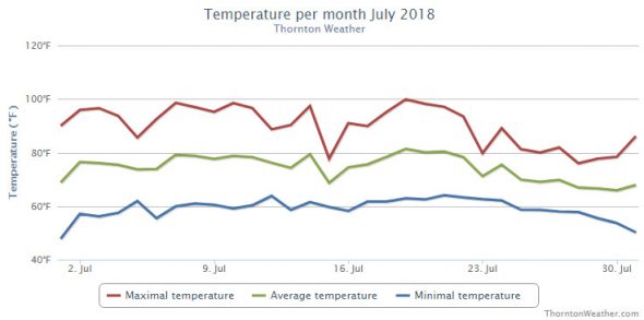
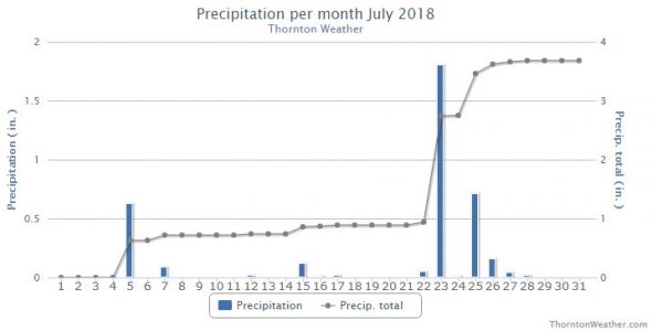
With 1.80 inches having fallen in the bucket yesterday afternoon and evening, Thornton saw a big boost in our rainfall totals for July and the entire year.

In fact, the 1.80 inches from that one storm was more precipitation than we had seen in any single month yet this year.

It did push the month’s rainfall total to above the 11 year average for July however, for 2018 we are still lagging almost 2 inches below what we would normally see by the end of July.

There are still seven days left in the month and monsoonal flow does look to be present in the coming days so we certainly could see things improve further.

You can check out this chart and other monthly summary reports for other weather data here.

Thornton, Colorado monthly rainfall summary for 2018 as of July 24. (ThorntonWeather.com)

July 15 to July 21: This week in Denver weather history

This week in Denver weather history
July 15 to July 21: This week in Denver weather history

Denver’s weather is rarely boring and our look back at this week in Denver weather history shows that. There have certainly been many notable thunderstorms with hail and damaging wind. However the most interesting item is the first – and only – recorded instance of snow during the month of July in the Mile High City.

From the National Weather Service:

7-25

In 1934…a streak of 15 consecutive days of 90 degrees ranked 5th on the list of hot streaks. The record of 24 consecutive days was established in the summer of 2008.
13-5

In 2008…a streak of 24 consecutive days of 90 degrees shattered the previous record of 18 consecutive days established in 1901 and 1874. Ironically…no new single day record high temperatures were set in the month of July. In August however…a record of 104 degrees was set on the 1st…and another record of 103 degrees was set on the 2nd. In addition…a record low min of 70 degrees was set on August 2nd.

14-15

In 1985…thunderstorms dumped heavy rain and hail at numerous locations along the Front Range from Denver north. Some of the heaviest rain fell in northern and western suburbs of Denver. Up to 2.6 inches of rain drenched Arvada…and Thornton was soaked with 2 inches in 45 minutes. At least 5 homes in Arvada suffered extensive damage from water and mud…and many streets and basements were flooded. In southern Jefferson County…11 homes were struck by lightning.

15

In 1879…a terrific hail storm occurred in the vicinity of Buffalo Station on the south park railroad in the South Platte River canyon about 39 miles south of Denver. Stones as large as hen’s eggs fell thick and fast and broke nearly every pane of glass in the windows of the building. A “waterspout” or cloudburst caused much loss of property from flash flooding on a nearby gulch. The torrent of water caused a deafening roar as it uprooted trees and carried huge Boulders and other debris. It struck the house and sawmill simultaneously and carried them away like straws…leaving little behind. The water continued to rush down the gulch for several hours. Serious damage was done to the south park railroad. The track and roadbed were destroyed for several miles. At about the same time…heavy rains in the vicinity of the headwaters of Cherry Creek produced a rapid rise in the creek…which drowned a few head of cattle and washed away two footbridges and some fences. Only 0.10 inch of rainfall was recorded in Denver.

In 1896…a thunderstorm produced sustained southwest winds to 40 mph with gusts to 46 mph.

In 1902…the temperature reached a high of 100 degrees in downtown Denver…which was a record maximum for the date.

In 1929…a thunderstorm did considerable damage to property in the eastern portion of the city. Heavy hail ranging in size from 1/4 to 3/4 inch in diameter…severe lightning… And high winds accompanied the heavy rain. Basements were flooded…and streets were impassable in places for several hours due to the heavy rainfall. Lightning damaged several telephone poles. Hail did extensive damage to gardens and flowers. The hail was up to a foot deep in places. There was no estimate of damage from the storm. A thunderstorm produced only a trace of rain and east winds to 24 mph in downtown Denver.

In 1959…thunderstorm rain totaled 0.41 inch in 8 minutes and winds gusted to an estimated 50 mph near downtown Aurora where half inch diameter hail was also reported. After the storm moved to the east…complete double rainbows were observed from the weather bureau office at Stapleton Airport.

In 1962…hail pelted the area in Adams County around Henderson and Brighton…causing extensive damage to corn…grain…beets…and row crops. Crop damage was estimated at 250 thousand dollars.

In 1963…a man received severe burns when struck by lightning while painting a building in south Denver.

In 1965…a state patrolman sighted a tornado near Bennett. It touched down over open ground…but caused no damage.

In 1967…heavy rains flooded streets and underpasses in south Denver. Heavy rain and minor wind damage were reported in wheat ridge…Aurora…Englewood…and Littleton. Basements were flooded and power disrupted. The clouds and rain resulted in a high temperature of only 72 degrees…which was a record low maximum for the date.

In 1974…a severe lightning storm damaged several homes and caused a number of power outages in both Denver and western Arapahoe counties.

In 1975…lightning killed a girl west of Boulder.

In 1982…winds gusted to 60 mph at Stapleton International Airport…and strong winds blew down walls at a construction site in Aurora where a nearby tree was uprooted.

In 1985…0.79 inch of rain fell in 30 minutes at Castle Rock. Much of the town lost power when lightning struck the town’s transformer.

In 1992…a man was struck by lightning while horseback riding near Castle Rock. Two people were struck by lightning near Highlands Ranch in south metro Denver. A man was struck by lightning while riding in the back of a pick-up truck in Franktown. All received minor injuries. Strong thunderstorms moved through east metro Denver…producing large hail and flash flooding. Hail up to 1 1/4 inches in diameter fell near Buckley Air National Guard base. Rainfall of 1 to 3 inches fell in Aurora in less than an hour…leaving water up to 18 inches deep in some areas. Thunderstorm rainfall was measured at 0.97 inch at Stapleton International Airport…where 3/8th inch diameter hail fell and south winds gusted to 44 mph.

In 1993…dime size hail fell in Golden. National weather service observers at Stapleton International Airport sighted a small rope-like funnel overhead for about 3 minutes before it dissipated.

In 1994…a small…short-lived tornado caused damage to a house under construction in Parker.

In 1995…thunderstorm winds of unknown strength downed trees and branches…damaging a porch and nearby cars in Denver.

In 1998…hail to 7/8 inch in diameter fell near Keenesburg.

In 2000…this date marked the end of a near record hot streak for metro Denver. The high temperature at Denver International Airport equaled or exceeded the 90-degree mark for 17 consecutive days…from June 29th. This was one day short of equaling the all time record. The record of 18 consecutive days was set in two different years…July 1st-18th…1874 and July 6th-23rd…1901.

In 2005…severe thunderstorms produced large hail over southeast metro Denver. Hail as large as 1.75 inches in diameter fell in southwest Aurora along with 7/8 inch hail in centennial. Hail to 3/4 inch in diameter was measured near centennial airport and near Watkins.

In 2015…A severe thunderstorm produced a peak wind gust to 60 mph from the northwest at Denver International Airport. In addition…0.06 inches of rainfall was also observed.

In 2016…large hail ranging in size from 1 to 2 inches in diameter struck Aurora…Castle Rock…Centennial…Greenwood Village and southeast Denver. The hail shattered

15-16

In 2006…a brief mid July hot spell resulted in two 100 plus degree high temperatures and two daily maximum temperature records. The high temperature climbed to 101 degrees on the 15th and 103 degrees on the 16th at Denver International Airport.

16

In 1911…thunderstorm winds were sustained to 44 mph from the northwest.

In 1959…a thunderstorm produced 3/8 inch diameter hail and a wind gust to 60 mph at Stapleton Airport.

In 1972…two tornadoes were sighted by the public to the southeast of Aurora. No damage was reported.

In 1978…a thunderstorm wind gust to 52 mph was recorded at Stapleton International Airport.

In 1980…a severe thunderstorm ripped through metro Denver… Producing torrential rain…large hail…and strong winds.

In Aurora…winds gusted to 65 mph with hail up to 1 1/2 inches in diameter and half an inch of rain in just 10 minutes. Stapleton International Airport was closed for an hour. Large hail also fell in southeast Denver…Lakewood…Parker… And Castle Rock. Up to 1 1/2 inches of rain fell in just 40 minutes. Heavy rains in wheat ridge flooded a shopping center…breaking windows and doors…while causing 100 thousand dollars in damage. Some roofs and windows were damaged throughout metro Denver. At Stapleton International Airport where west winds gusted to 49 mph…1/4 inch hail and 0.77 inch of rain fell.

In 1983…severe thunderstorms dumped large hail over much of metro Denver. Hail to 3/4 inch in diameter fell in Littleton and Northglenn…with 3/4 to 1 inch hail in Arvada…1 to 1 1/2 inch hail in extreme northwest Denver…1 3/4 inch hail in Lakewood…1 1/2 inch hail in south Arvada and just northeast of Aurora…and 1 5/8 inch hail on green mountain.

In 1994…spotters reported a brief tornado touchdown in an open field just north of Fort Lupton. No damage or injuries were reported.

In 2000…very moist and unstable weather conditions…along with low level upslope flow during the late afternoon and evening…combined to produce heavy thunderstorm rainfall… Which caused urban and small stream flooding across metro Denver. Rainfall amounts generally ranged from 1 to 3 inches with the heaviest rainfall occurring during the evening hours. Two miles east of white ranch in northern Jefferson County… An automated rain gage measured 3.86 inches of rain. Since the rain fell in a relatively open area…no flood damage was reported. However…in greenwood village near the intersection of Peoria and Belleview…the streets were closed for several hours with as much as 2 feet of standing water covering the roadways. Two campers near Mt. Evans were injured by lightning and stranded overnight by the inclement weather. Both received minor injuries.

In 2003…the high temperature of 101 degrees was a record maximum temperature for the date.

In 2004…locally heavy rainfall of unknown amount caused parts of the Virginia Canyon road near Idaho Springs to wash out. The road had to be closed temporarily.

In 2005…the temperature climbed to a high of 102 degrees at Denver International Airport. This was a new record maximum temperature for the date at the time.

Continue reading July 15 to July 21: This week in Denver weather history

July 8 to July 14: This week in Denver weather history

This week in Denver weather history
July 8 to July 14: This week in Denver weather history

In looking back at this week in Denver weather history, one cannot be struck by the hail storms listed, if not for sheer number then by the damage they caused. The biggest of these storms occurred in 1990 and stands in the books as the most damaging hailstorm in United States history.

From the National Weather Service:

29-15

In 2000…the 29th marked the beginning of a near record hot streak for metro Denver. The high temperatures…as recorded at Denver International Airport…exceeded the 90 degree mark for 17 consecutive days from June 29th through July 15th. The record of 24 consecutive 90 degree or above days was set from July 13th through August 5th…2008.

1-18

In 1874…a streak of 18 consecutive days of 90 degrees tied for second with another streak that was later set in the summer of 1901. The record of 24 consecutive days was established in the summer of 2008.

4-8

In 1989…one of the most intense heat waves on record roasted metro Denver. The temperature reached 100 degrees or more on 5 consecutive days. The city had previously never recorded more than 2 straight 100-degree days since records began in 1872. Water and electricity usage reached all time highs. The heat wave created extremely dry weather conditions…which contributed to a major forest fire in Boulder canyon on July 9th. The temperature reached 103 degrees on the 8th…and the mercury climbed to 101 degrees on both the 4th and 5th…and to 102 degrees on both the 6th and 7th. The low temperature of 68 degrees on the 8th equaled the record high minimum for the date.

6-23

In 1901…a streak of 18 consecutive days of 90 degrees tied for second with another streak set in the summer of 1874. The record of 24 consecutive days was established in the summer of 2008.
7-25

In 1934…a streak of 15 consecutive days of 90 degrees ranked 5th on the list of hot streaks. The record of 24 consecutive days was established in the summer of 2008.

8

In 1905…a thunderstorm produced 0.82 inch of rainfall and northeast winds sustained to 48 mph.

In 1977…strong winds turned over 2 light aircraft at Arapahoe County Airport…now centennial airport.

In 1987…a weak tornado was observed near Bennett.

In 1988…three separate tornadoes were sighted near Bennett. No damage was reported. One inch diameter hail was also reported.

In 1991…lightning started three house fires in Castle Rock. Damage totaled 13 thousand dollars. No injuries were reported.

In 1993…a dry thunderstorm microburst wind gust to 55 mph briefly reduced the surface visibility to 3 miles at Stapleton International Airport.

In 1997…one construction worker was killed and two others injured when a strong thunderstorm wind gust caused the scaffolding they were standing on to collapse near Parker. A dry microburst produced a wind gust to 54 mph at Denver International Airport.

In 1998…heavy thunderstorm rain forced the closure of Hampden Avenue between I-25 and Havana Street in southeast Denver. The high water made 2 or 3 lanes of the street impassable.

In 2001…severe thunderstorms produced large hail…damaging winds…and heavy rain across south metro Denver. Two people received minor injuries when a severe thunderstorm wind gust to 58 mph blew over several tents at the Cherry Creek Arts Festival. The same storm caused the roof of a hardware store in Tamarac Square to collapse. One employee received minor injuries when she was struck in the head by falling debris. The combination of intense rain and wind downed trees and power lines. Electrical power outages affected 35 thousand homes and businesses. At least 50 trees in city parks across south Denver were damaged. Up to 4.50 inches of thunderstorm rain fell across portions of southeast metro Denver. The underpass at I-25 and Parker road was inundated with 5 feet of water. Several other streets and underpasses in Aurora were also closed due to high water. Heavy rain caused extensive damage to several exhibits at the Cherry Creek Arts Festival. Flash flooding occurred when heavy thunderstorm rainfall caused toll gate creek to jump its banks. Several underpasses across south Denver had to be closed due to high water. A man received minor injuries when lightning struck a nearby tree at the Wellshire Golf Course. Hail as large as 1 1/4 inches in diameter fell in Englewood with 1 inch hail in the city of Denver…and 3/4 inch hail in Littleton. Thunderstorm winds gusted to 63 mph at Denver International Airport and to 62 mph in Englewood.

In 2005…a tornado touched down briefly near Brighton…but caused no damage.

In 2011…severe thunderstorms produced hail…up to 1 inch in diameter…and wind gusts to 60 mph across parts of Adams…Broomfield and Denver counties. At Denver International Airport…a peak wind gust to 59 mph from the west.

In 2017…a strong thunderstorm produced hail up to 7/8 inch in diameter in southwest Denver.

9

In 1872…a very brisk wind between 2:00 pm and 3:00 pm spread a cloud of dust and sand into the city.

In 1874…northeast winds at sustained speeds up to 36 mph blew immense clouds of dust from the prairie through the streets of the city around mid-morning. The houses across the street from the weather station were not visible at the peak of the storm.

In 1875…heavy thunderstorm rains caused stream flooding… Which damaged nearly all railroads into the city. Rainfall in the city was only 0.14 inch.

In 1953…heavy thunderstorm rains caused an estimated 2 million dollars damage from flooded stores and basements across metro Denver. The flood waters reached a depth of 3 feet on streets in some sections of the city…damaging streets and automobiles. The heavy rainfall at Lowry Air Force Base totaled 3.90 inches. At Stapleton Airport where the heavy rain briefly reduced the surface visibility to 1/2 mile…only 1.05 inches of rain were measured. North winds gusting to 52 mph caused some damage in east Denver.

In 1982…two small tornadoes were spotted east of Rocky Flats… And a tornado touched down briefly 5 miles east of Brighton. No damage was reported.

In 1984…heavy rain fell over southern sections of metro Denver. Rainfall totaled 1.50 inches in just 15 minutes between Littleton and Sedalia.

In 1987…a thunderstorm microburst produced a wind gust of 58 mph at Erie north of Denver.

In 1988…hail to 3/4 inch in diameter piled up 2 to 4 inches deep in Idaho Springs. Some basements were flooded and several thousand gallons of fuel were contaminated when water flooded a gasoline storage tank. A tornado sighted near Manilla 5 miles west of Bennett remained on the ground for 9 minutes. No damage was reported.

In 1990…a severe thunderstorm produced a tornado and heavy rain over northeast metro Denver. As much as 4 inches of rain fell in just 20 minutes in Commerce City…causing the South Platte River to rise quickly and flood lowland areas. The raging flood waters caused extensive damage to a 30-foot stretch of railroad track embankment…destroyed a railroad trestle and a nearby garage…and washed away a vintage 1960’s show car near east 58th avenue and York Street. The car was found a couple of miles downstream in a pool of deep mud and murky water. Rainfall totaled 1.34 inches at Stapleton International Airport where 1/2 inch diameter hail fell. The same thunderstorm produced a brief tornado in a vacant field near 64th avenue and tower road just east of the rocky mountain arsenal. No damage was reported from the twister. Lightning from the storm caused power outages to as many as 7 thousand homes and businesses.

In 1996…a tornado (f0) was reported 5 miles south of Hudson. No damage was reported. Twin weak tornadoes (f0) formed for a short time near the northeast runways at Denver International Airport. Less than 15 minutes later…a weak tornado (f0) touched down in the employee parking lot at dia. Several car windows were blown out…and a few vehicles sustained minor body damage from flying debris. Several signs were also blown down. Later…twin weak tornadoes (f0) touched down again in open country between DIA and Watkins.

In 2004…severe thunderstorms produced hail to 3/4 inch in diameter near tiny town and wind gusts to 66 mph in Bennett. A thunderstorm wind gust to 56 mph was measured at Denver International Airport.

In 2005…a thunderstorm produced a wind gust to 54 mph at Denver International Airport.

9-10

In 1980…a series of severe thunderstorms hit metro Denver… Dumping heavy rain and producing a spectacular lightning display lasting for several hours. A number of homes were damaged by lightning. Winds gusted to 60 mph at Stapleton International Airport where about half an inch of rain fell in just 10 minutes along with 1/4 inch diameter hail. The evening thunderstorms continued into the early morning hours with total rainfall of 1.35 inches at Stapleton International Airport.

In 1998…thunderstorm rainfall totaled 2.04 inches at the site of the former Stapleton International Airport.

10

In 1878…a lunar rainbow was observed during a light mist and fog.

In 1895…the temperature warmed to a high of only 53 degrees… The all-time record lowest maximum temperature for the month of July.

In 1967…golf ball size hail damaged aircraft at Jefferson County Airport near Broomfield.

In 1983…two people were injured when struck by lightning just southwest of Morrison. A man was injured when he was swept downstream by a flash flood on a tributary of Clear Creek in the canyon 8 miles west of Golden. Heavy thunderstorm rains caused mudslides which closed several roads. Rainfall amounts included: 1.75 inches in 20 minutes in southeast Denver…1.26 inches in 35 minutes in Boulder…2.14 inches in 2 hours in Lakewood…1.70 inches in 45 minutes in Aurora…and 1.25 inches in 30 minutes atop Floyd Hill in the foothills west of Denver.

In 1992…storm spotters reported 3/4 inch diameter hail near the construction site of the new Denver airport just northeast of the city.

In 1995…microburst winds toppled a pine tree 60 feet high and 2 feet in diameter in Denver. The tree fell and injured a man nearby. Microburst winds to 59 mph broke the glass on a door at the national weather service forecast office at the site of the former Stapleton International Airport.

In 1998…thunderstorm rainfall totaled 2.35 inches at Denver International Airport.

In 2000…three children were injured…one critically…when lightning hit a nearby tree at panorama point atop flagstaff mountain just west of Boulder. Lightning hit the tree…entered the ground…then struck the children. Lightning sparked a grassfire that burned about 50 acres at the Rocky Flats Environmental Test Facility. Also… Lightning sparked at least 6 fires in the Hudson and Keenesburg areas as thunderstorms…accompanied with heavy rain…large hail…and tornadoes…moved through southern Weld County. Over 2 inches of very heavy rain caused flooding along an I-76 exit ramp near Keenesburg. The fire department rescued 15 stranded motorists as high water inundated sections of the exit ramp and adjacent highway. Basements were also flooded in Keenesburg. One home reportedly had 7 feet of standing water in the basement before the rain subsided. A weak tornado (f0) touched down briefly near Brighton…but caused no damage.

In 2001…a severe thunderstorm dumped 7/8 inch diameter hail in Wheat Ridge.

In 2002…severe thunderstorms pelted the southern suburbs of metro Denver with large hail. Hail as large as 3 inches in diameter fell 6 miles southeast of Parker. Other large hail reports included 2 inch diameter hail around centennial airport and 3/4 inch hail near Sedalia and Deckers. Hail as large as 3/4 inch was also reported in Broomfield. Runoff from heavy thunderstorm rainfall in the Hayman fire burn area flooded lost creek ranch with up to 18 inches of water just off State Highway 126. Floodwaters damaged a very expensive rug in the lodge. A driveway to a residence was washed away.

In Douglas County…runoff damaged forest access roads in the turkey creek drainage.

In 2011…a severe thunderstorm produced intense microburst winds in southeast Boulder County. A peak wind gust to 75 mph was recorded in superior with gust to 58 mph…2 miles south of Lafayette. At Denver International Airport…a peak wind gust of 31 mph was recorded.

Continue reading July 8 to July 14: This week in Denver weather history

July 1 to July 7: This week in Denver weather history

This week in Denver weather history
July 1 to July 7: This week in Denver weather history

In our July weather preview we discussed how the month is not only Denver’s hottest but also its stormiest. Our look back at this week in Denver weather history helps to illustrate that fact. We start seeing 100+ degree days as well as many of the types of fast moving thunderstorm events expected this time of year.

From the National Weather Service:

29-2

In 1990…almost a year to date after the record breaking heat in early July 1989…the third longest heat wave in Denver history started. From June 29th through July 2nd the temperature reached 100 degrees or more on four consecutive days. The highest reading of 102 degrees occurred on the 29th…30th…and 1st. Combined with the 102 degree reading on June 27th this would have been the longest heat wave on record…but the temperature climbed to only 98 degrees on June 28th.

29-15

In 2000…the 29th marked the beginning of a near record hot streak for metro Denver. The high temperatures…as recorded at Denver International Airport…exceeded the 90 degree mark for 17 consecutive days from June 29th through July 15th. The record of 24 consecutive 90 degree or above days was set from July 13th through August 5th…2008.

30-1

In 1873…heavy rainfall overnight totaled 1.42 inches. Mountain peaks to the southwest of the city were covered with fresh snow on the morning of the 1st.

1

In 1915…northeast winds sustained to 41 mph with gusts to 50 mph occurred just before a thundershower in the evening. Rainfall was only 0.07 inch.

In 1941…unusually heavy thunderstorm rains flooded basements and blocked traffic. Water was curb high on many downtown streets. The thunderstorm also pelted the city with hail of unknown size. Rainfall in downtown Denver totaled 0.72 inch…but greater amounts likely occurred in other parts of the city.

In 1960…a severe dust devil moving through an Adams County suburban area blew over a fireworks stand…injuring an 11- year-old boy customer and two women operators of the stand. The boy was found under the demolished stand 100 feet away.

In 1961…hail as large as 1 1/4 inches in diameter was reported over east Denver.

In 1967…golf ball size hail fell over portions of metro Denver. Hail stones to 2 inches in diameter damaged roofs and broke windows in northeast Boulder. Marble to golf ball size hail fell at the Boulder airport. A funnel cloud was sighted over the foothills near Boulder. Hail stones of 1 to 2 inches in diameter were measured at Jefferson County Airport near Broomfield. Marble size hail fell in the vicinity of Arvada and Westminster.

In 1982…severe thunderstorms dropped large hail in Denver… Boulder…Commerce City…Lakewood…Wheat Ridge…Golden…and Arvada. Most locations reported hail size from 3/4 to 1 1/4 inches in diameter.

In 1990…the high temperature reached 102 degrees at Stapleton International Airport.

In 1998…hail to 1 1/2 inches in diameter fell near Bennett.

In 2001…the temperature climbed to a high of 101 degrees at Denver International Airport.

In 2016…a severe thunderstorm produced large hail in Castle Rock…ranging in size from 1 to 2 inches in diameter. The hail pummeled neighborhoods as it smashed cars and shattered windows. The storm caused extensive damage to shutters…roofs…siding and fencing.

1-18

In 1874…a streak of 18 consecutive days of 90 degrees tied for second with another streak that was later set in the summer of 1901. The record of 24 consecutive days was established in the summer of 2008.

1-31

In 2012…it was the hottest July on record in Denver since weather records began in 1872. The average temperature for the month was 78.9 degrees which was 4.7 degrees above normal. There were 27 days in which the high temperature equaled or exceeded 90 degrees…which established a new record. There were also 7 days in which the temperature equaled or exceeded 100 degrees which tied the record set in 2005.

2

In 1879…a severe hail storm produced considerable damage in the vicinity of Arvada. Some of the stones were unusually large…measuring 6.5 inches in circumference (2 inches in diameter) with an average weight of 1 ounce. The stones were uniformly large with one side concave. The greatest damage was to early wheat…cabbage…and vines. A tree just to the south of the weather station in downtown Denver was struck by lightning. Residents in the house 15 feet away were affected by the strike.

In 1885…thunderstorm winds were sustained to 50 mph in the city.

In 1892…an apparent cold front produced sustained northeast winds to 40 mph with gusts to 45 mph.

In 1955…a apparent microburst wind gust to 69 mph was recorded at Stapleton Airport where the brief strong wind reduced the visibility to zero in blowing dust.

In 1965…hail…up to 2 inches in diameter…struck southwest Adams and northeast Denver counties…damaging cars…windows… And foliage. Hail accumulated up to a foot deep. Wind gusts to 48 mph and hail to 1 inch in diameter fell at Stapleton International Airport where the large hail broke three storm windows and shredded shrubs at the U.S. Weather Bureau Upper Air building.

In 1968…a pilot reported a tornado 10 miles southeast of Parker.

In 1971…one inch diameter hail stones were reported in Adams County about 30 miles east of Denver.

In 1987…a large tornado touched down 10 miles northeast of Stapleton International Airport. The tornado was vertical and thick and kicked up a large dust and debris cloud. Later…it developed a sinuous rope-like shape as it slowly dissipated. The tornado was visible for 15 minutes. The twister occurred in open country and did only minor damage to a metal shed…porch…and mailbox. A man was killed by lightning in southwest Aurora. He was in his backyard and had a shovel in his hand at the time of the strike. A group of soccer players were hit by lightning on a field in Boulder. A 10-year-old boy was critically injured and hospitalized; fortunately he recovered. Six other people were knocked to the ground by the strike. Two of these were slightly injured. Golf ball size hail fell just east of Littleton and at Highlands Ranch. Hail as large as 3/4 inch in diameter was reported in Aurora and Parker and near Hudson and Franktown.

In 1988…a 45-year-old man was injured by lightning at Cheery Creek Reservoir. Administration of CPR probably saved his life.

In 1990…the temperature reached a high of 100 degrees at Stapleton International Airport.

In 1993…thunderstorm winds blew a roof off a barn near Parker…causing an estimated 15 hundred dollars damage.

In 1994…thunderstorm winds downed power lines in Boulder… Causing power outages. Winds gusted to 66 mph in Boulder… 64 mph in Arvada…and 60 mph in Golden.

In 1998…a small tornado touched down briefly near Barr Lake… But caused no damage.

In 2002…hail as large as 1 3/4 inches in diameter fell in the city of Denver and in Arapahoe County near Littleton. The low temperature of 69 degrees equaled the record high minimum for the date.

In 2006…lightning struck a teenager in Castle Rock as he was mowing his lawn and listening to an iPod. The teen suffered burns to his hands and feet…and had blood running from his ears when he was found. The victim’s eardrums were ruptured…which damaged his hearing. Lightning also struck a house in Castle Rock causing extensive damage to the roof and side of the home. Heavy rains caused flash flooding at Castlewood Canyon State Park near Franktown. The floodwaters destroyed four footbridges along the high trail. A culvert and several roads were washed out in the area. In addition… Two driveways crossing Cherry Creek were washed out near Prairie Canyon Ranch. Heavy rainfall also caused minor flooding on murphy and sand creeks…just east of Buckley AFB. Gun Club Road was closed between Alameda and Mississippi avenues…north of the Murphy Creek Golf Course…where 3 feet of standing water reportedly covered the road. A severe thunderstorm produced large hail to 7/8 inch in diameter in south Aurora near Cherry Creek.

In 2016…a weak landspout touched down briefly in and open field near Bennett.

Continue reading July 1 to July 7: This week in Denver weather history

July 2017 weather recap: Thornton sees average temps but little precipitation

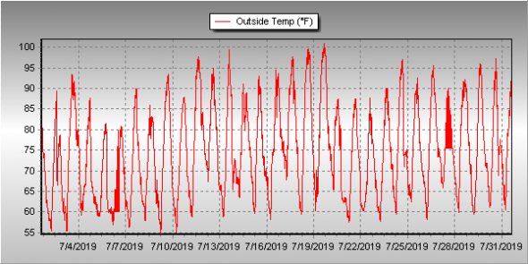
The month of July might have seemed quite hot but in fact mercury readings were right near normal. What likely caused the misconception is the fact that we saw far less than normal rain.

High pressure did dominate for much of the month and while monsoonal flow did bring rain to eastern Colorado, it largely missed our area.  The Palmer Divide and southeastern Colorado were beneficiaries for much of the month but for us it wasn’t until the last week that we saw relief.

Thornton’s average temperature for the month came in at 74.1 degrees.  This is almost exactly matches Denver’s long-term July average of 74.2 degrees.  Out at DIA where the Mile High City’s official temperatures are taken, it shows a far warmer month with an average of 76.4 degrees.

Temperatures here ranged from a maximum of 99.2 degrees on the 19th down to a low of 50.1 degrees on the morning of the 1st.  Out at the airport, their highest reading was actually 100 degrees seen on the 6th and again on the 19th.  The low out there was 51 degrees on the 1st.

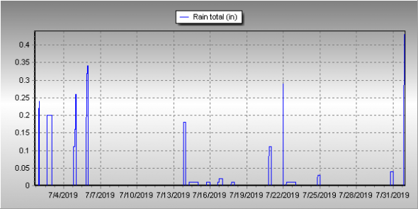
On average Denver receives 2.16 inches of precipitation during July.  Both Thornton and Denver fell far short of that mark.  We managed to record 0.61 inches in our bucket during the month, more than half of which fell on the second to last day of the month. At DIA, Denver recorded 0.47 inches.

Click here to view Thornton’s July 2017 climate report.

Thornton, Colorado's July 2017 temperature summary. (ThorntonWeather.com)
Thornton, Colorado’s July 2017 temperature summary. (ThorntonWeather.com)
Thornton, Colorado's July 2017 precipitation summary. (ThorntonWeather.com)
Thornton, Colorado’s July 2017 precipitation summary. (ThorntonWeather.com)

From the National Weather Service:

CLIMATE REPORT
NATIONAL WEATHER SERVICE DENVER/BOULDER CO
656 AM MDT TUE AUG 1 2017

...................................

...THE DENVER CO CLIMATE SUMMARY FOR THE MONTH OF JULY 2017...

CLIMATE NORMAL PERIOD 1981 TO 2010
CLIMATE RECORD PERIOD 1872 TO 2017

WEATHER         OBSERVED          NORMAL  DEPART  LAST YEAR`S
                 VALUE   DATE(S)  VALUE   FROM    VALUE  DATE(S)
                                          NORMAL
................................................................
TEMPERATURE (F)
RECORD
 HIGH             105   07/20/2005
 LOW               42   07/04/1903
                        07/31/1873
HIGHEST           100   07/19        99      -5      102  07/10
                        07/06
LOWEST             51   07/01        51       9       51  07/12
AVG. MAXIMUM     91.5              89.4     2.1     92.0
AVG. MINIMUM     61.3              58.9     2.4     60.5
MEAN             76.4              74.2     2.2     76.2
DAYS MAX >= 90     20              16.0     4.0       22
DAYS MAX <= 32      0               0.0     0.0        0
DAYS MIN <= 32      0               0.0     0.0        0
DAYS MIN <= 0 0 0.0 0.0 0 
PRECIPITATION (INCHES) 
RECORD
 MAXIMUM 6.41 1965
 MINIMUM 0.01 1901 
TOTALS 0.47 2.16 -1.69 1.07 
DAILY AVG. 0.02 0.07 -0.05 0.03 
DAYS >= .01         6               8.3    -2.3        6
DAYS >= .10         3               4.3    -1.3        4
DAYS >= .50         0               1.4    -1.4        1
DAYS >= 1.00        0               0.7    -0.7        0
GREATEST
 24 HR. TOTAL    0.15   07/21 TO 07/21           07/01 TO 07/01
                                                          06/30 TO 07/01
                                                          07/01 TO 07/01

SNOWFALL (INCHES)
RECORDS TOTAL      0.0
 TOTALS            0.0 2017         0.0

DEGREE_DAYS
HEATING TOTAL       0                 6      -6        0
 SINCE 7/1          0                 6      -6        0
COOLING TOTAL     360               289      71      356
 SINCE 1/1        533               444      89      544

FREEZE DATES
RECORD
 EARLIEST     09/08/1962
 LATEST       06/08/2007
EARLIEST                        10/07
LATEST                          05/05
..................................................

WIND (MPH)
AVERAGE WIND SPEED              9.6
RESULTANT WIND SPEED/DIRECTION   3/204
HIGHEST WIND SPEED/DIRECTION    45/120    DATE  07/15
HIGHEST GUST SPEED/DIRECTION    53/120    DATE  07/15

SKY COVER
POSSIBLE SUNSHINE (PERCENT)   MM
AVERAGE SKY COVER           0.50
NUMBER OF DAYS FAIR            6
NUMBER OF DAYS PC             21
NUMBER OF DAYS CLOUDY          4

AVERAGE RH (PERCENT)     45

WEATHER CONDITIONS. NUMBER OF DAYS WITH
THUNDERSTORM              9     MIXED PRECIP               0
HEAVY RAIN                0     RAIN                       3
LIGHT RAIN                9     FREEZING RAIN              0
LT FREEZING RAIN          0     HAIL                       0
HEAVY SNOW                0     SNOW                       0
LIGHT SNOW                0     SLEET                      0
FOG                       3     FOG W/VIS <= 1/4 MILE      1
HAZE                      3

-  INDICATES NEGATIVE NUMBERS.
R  INDICATES RECORD WAS SET OR TIED.
MM INDICATES DATA IS MISSING.
T  INDICATES TRACE AMOUNT.

July 30 to August 5: This week in Denver weather history

This Week In Denver Weather History
July 31 to August 6: This Week in Denver Weather History

How does 42 degrees sound right about now? That mark is one of the highlights of this week in Denver weather history. It was the low temperature recorded twice in our past and the coldest July temperature on record. Many more notable events have also occurred.

From the National Weather Service:

13-5

In 2008…a streak of 24 consecutive days of 90 degrees shattered the previous record of 18 consecutive days established in 1901 and 1874. Ironically…no new single day record high temperatures were set in the month of July. In August however…a record of 104 degrees was set on the 1st…and another record of 103 degrees was set on the 2nd. In addition…a record low min of 70 degrees was set on August 2nd.

18-2

In 1987…a streak of 16 consecutive days of 90 degrees ranked 4th on the list of hot streaks. The record of 24 consecutive days was established in the summer of 2008.

27-31

In 1956…96 percent of the total precipitation for the month of July occurred over the last five days of the month. Heavy thunderstorms produced 4.00 inches of rainfall at Stapleton Airport. This amount of precipitation in 5 days or less had been exceeded only 3 times in previous record. The last time had been in December of 1913 as snow. Considerable property damage occurred across metro Denver from flooding.

28-30

In 1889…dense smoke from forest fires in the mountains obscured the sun over the city for three days.

In 1971…a vigorous cold front late on the 28th produced northeast wind gusts to 39 mph and record breaking cold temperatures on the 29th and 30th. The temperature dipped to 47 degrees on the 29th and 43 degrees on the 30th… Setting record minimums for the dates. Upslope cloudiness along with rain and fog early on the 29th helped set a record low maximum temperature of 58 degrees for the date.

29-30

In 1997…heavy rain caused flooding and flash flooding in central portions of Adams and Arapahoe counties. Two homes were extensively damaged when water flooded the basements and adjacent pasture area in Strasburg. Water 4 to 5 feet deep had pooled in the lower lying areas of the town. A portion of Quincy Road was closed in Arapahoe County when 4 feet of water covered the roadway. Rainfall totaled 3.06 inches at Denver International Airport…establishing a new record for 24-hour rainfall in July. The previous record was 2.42 inches set in 1965 on the 24th and 25th.

30

In 1879…lightning struck a brick kiln in north Denver. Three men were knocked senseless…but all recovered. Rainfall in the city was only 0.09 inch.

In 1881…a thunderstorm dumped heavy rain and hail on the city…causing street flooding and much damage. A heavy torrent of rain fell with 1.10 inches measured in just 20 minutes. Storm total rainfall was 1.60 inches. The rain turned streets into running streams. Wood street crossings were torn up and washed away. The storm caused great damage by flooding many cellars where goods were stored. The brick yards suffered severe damage when the heavy rainfall destroyed many unfired bricks.

In 1913…northeast winds were sustained to 41 mph with gusts to 48 mph.

In 1939…a thunderstorm produced 0.08 inch of rainfall. This was the only measurable precipitation of the month…making the month the second driest July on record.

In 1961…heavy rain and lightning disrupted power lines and caused flooding in Denver. Thunderstorm rains totaled 1.60 inches at 11th and Lincoln in central Denver.

In 1972…the temperature climbed to a high of 100 degrees at Stapleton International Airport.

In 1983…hail 3/4 to 1 inch in diameter fell in central and southeast Denver and in Littleton. Rainfall of 1.50 inches occurred in just 30 minutes in Littleton. There was some street flooding in both cities with wind gusts up to 55 mph.

In 1984…central Aurora was hit by a downpour that produced 1.80 inches of rain and sent water 2 to 3 feet deep into some streets. Before the rain stopped later in the evening… The storm had dropped as much as 2.80 inches of moisture on the city. Thunderstorm rainfall totaled only 0.82 inch at Stapleton International Airport.

In 1985…a tornado was spotted in open country 10 miles southwest of Bennett. No damage was reported. One inch hail was reported in south Lakewood.

In 1997…one man was killed and his girlfriend critically injured when they were struck by lightning on the Kennedy Golf Course in southeast Denver. Both were struck in the head when they took refuge under a tree during a downpour. Lightning struck a home in unincorporated Arapahoe County east of Buckley Field. The fire started in the electrical panel boxes…causing extensive damage to the home. Heavy rain and hail triggered a flash flood in Boulder…which sent water through a window of the financial aid office on the University of Colorado campus. In addition…ceiling tiles…carpets…and dressing rooms were damaged at the Coors Events Center when a pipe draining rainwater broke during the downpour. In all…10 buildings on the campus received water damage estimated at 100 thousand dollars. Hail as large as 1.25 inches in diameter accompanied the heavy rain in Boulder. Thunderstorm rainfall totaled 2.71 inches at Denver International Airport where west winds gusted to 41 mph. This was the greatest calendar day official precipitation ever recorded in July.

In 1998…heavy rain…up to 3 inches in an hour…caused flash flooding problems from Castle Rock to Parker. I-25 north of Castle Rock was closed as high waters covered sections of the highway. Some cars were left floating in the flood waters.

In 2001…a severe thunderstorm produced a wind gust to 70 mph at a wind sensor on the northeast corner of Denver International Airport.

In 2004…a severe thunderstorm produced wind gusts to 71 mph in Evergreen.

In 2005…the temperature climbed to a high of 101 degrees at Denver International Airport. This was a new record maximum temperature for the date.

In addition…this was the 7th day of the month with a high temperature of 100 degrees or more…which set a new Denver record for the most 100 degree days in a month…for a season…and in a year.

31

In 1873…the all-time lowest recorded temperature in July… 42 degrees…occurred. The same temperature also occurred on July 4…1903.

In 1874…during the late afternoon rain and hail fell for 5 minutes followed by brief heavy rain. Pieces of solid ice of irregular shape fell upon the roof of the station. The hail stones measured 1 1/2 inches in diameter. Precipitation (rain and melted hail) was only 0.16 inch.

In 1889…the high temperature climbed to 100 degrees in downtown Denver.

In 1919…heavy thunderstorm rainfall totaled 2.59 inches in downtown Denver during the evening. Rainfall was 1.90 inches in an hour…a new record at that time.

In 1961…over an inch of rain in a short period of time caused flooding of streets and basements in Denver. Rainfall totaled 1.30 inches at 11th and Lincoln in central Denver.

In 1964…the temperature reached 91 degrees in Denver…making this the 27th day of the month that the temperature reached 90 degrees or more. This is the all time record for 90 degree days in a month in Denver.

In 1972…one inch diameter hail fell in Hudson northeast of Denver.

In 1976…during the evening hours extremely heavy thunderstorm rains produced flash flooding in Big Thompson Canyon which killed 144 people between Estes Park and Loveland. No significant weather occurred in metro Denver at the time.

In 1987…1 inch diameter hail fell in Lakewood and 3/4 inch hail fell near Louisville. Southeast Boulder County was drenched with 1.25 inches of rain in just 20 minutes.

In 1993…thunderstorm winds damaged a chimney of a home near Parker.

In 1996…a weak tornado (f0) was sighted 12 miles east of Denver International Airport. No damage was reported.

In 1998…heavy monsoonal thunderstorm rain triggered a mud slide in Blackhawk. The mudslide blocked Main St. and caused an estimated half million dollars in damage to a casino. Heavy thunderstorm rain…up to 3 inches in an hour…caused a flash flood along Buffalo Creek. Portions of County Road 126 just south of the town of Buffalo Creek were washed out. The flood waters nearly washed away the bridge as mud and debris slammed into the structure. Hail to 1 3/4 inches in diameter fell near Idaho Springs.

In 2004…severe thunderstorm winds toppled a 65-foot blue spruce tree in Parker. The tree landed on a home damaging the roof and gutters. The downed tree poked dozens of holes into the shingles.

In 2013…severe thunderstorm winds… with gusts estimated to 80 mph…downed power poles which caused scattered outages in and around Byers…Bennett and Strasburg. Some property damage was also observed. Near Byers…aluminum siding and roofing was peeled off sheds. Large hail…up to one inch in diameter… was reported north of Bennett. At Denver International Airport…a peak wind gust to 40 mph was observed from the northeast.

1 Continue reading July 30 to August 5: This week in Denver weather history

July 23 to July 29: This week in Denver weather history

This Week In Denver Weather History
July 23 to July 29: This Week in Denver Weather History

As we near the end of July the weather in Denver tends to be a bit more stable. That doesn’t mean the severe weather threat disappears as can be seen at our look back at this week in Denver weather history. Particularly notable are lightning injuries and deaths, flash flood events and even tornadoes.

From the National Weather Service:

7-25

In 1934…a streak of 15 consecutive days of 90 degrees ranked 5th on the list of hot streaks. The record of 24 consecutive days was established in the summer of 2008.

13-5

In 2008…a streak of 24 consecutive days of 90 degrees shattered the previous record of 18 consecutive days established in 1901 and 1874. Ironically…no new single day record high temperatures were set in the month of July. In August however…a record of 104 degrees was set on the 1st…and another record of 103 degrees was set on the 2nd. In addition…a record low min of 70 degrees was set on August 2nd.

18-2

In 1987…a streak of 16 consecutive days of 90 degrees ranked 4th on the list of hot streaks. The record of 24 consecutive days was established in the summer of 2008.

19-23

In 2005…the high temperature climbed above 100 degrees on each of the 5 days with readings of 101 on the 19th…105 on the 20th…104 on the 21st…and 102 on both the 22nd and 23rd. A new record maximum temperature for the month of July of 105 degrees was set on the 20th…which also equaled the all time record maximum for Denver of 105 degrees first set on August 8th in 1878. Daily maximum temperature records were set on each day…and the 5 day period equaled the record for the most consecutive days of 100 degrees or more first set from July 4th through 8th in 1989. The intense heat resulted in a high use of electricity for cooling purposes. The demand for electric power exceeded the supply and rolling black-outs… Each lasting about an hour…were scheduled across metro Denver during the afternoons and early evenings.

20-23

In 1961…unusually cool weather for July resulted in several temperature records. Record minimum temperatures were set or equaled on each day with readings of 51…51…49… And 49 degrees. High temperature of only 64 degrees on the 21st was a record low maximum for the date.

20-25

In 1965…heavy showers and thunderstorms doused metro Denver with significant rain each day. Rainfall for the six days totaled 5.16 inches at Stapleton International Airport. Massive rainfall occurred on the 20th…21st…and 25th… Flooding streets and basements and causing streams to overflow. The heaviest rainfall…2.05 inches…at Stapleton International Airport occurred on the 25th.

22-23

In 1991…heavy rains over the palmer divide and along the Front Range caused the South Platte River to flood from near Henderson to Fort Lupton. The river was out of its banks at several locations with water covering the roads through the night. Only minor damage was reported.

24

In 1896…heavy cloudbursts in the foothills west of Denver caused flash flooding on Bear Creek…Clear Creek…Golden Gate Gulch…and Mount Vernon Creek…resulting in a total of 27 deaths. The downpour dislodged large Boulders…one of which crushed a house. The heavy rain also caused a dam on cub creek to wash out…adding even more water to the flood. A wall of water as high as 10 feet flooded Evergreen and passed down bear creek…washing away many structures along the way. The flood crest produced 3 feet of water in downtown Morrison during the early evening. Flash flooding on Mount Vernon Creek added to the flooding in Morrison. In Golden…the flooding washed out bridges on clear creek and on Cresman and Tucker gulches and forced the closure of the power plant. In Denver…a thunderstorm produced hail of unknown size during the afternoon and rainfall of 1.23 inches overnight.

In 1958…a thunderstorm wind gust to 52 mph was recorded at Stapleton Airport.

In 1965…heavy rain caused flooding on clear creek and tucker gulch in Golden and west Denver. Damage in Golden was estimated at 80 thousand dollars. Heavy rain south of Denver washed out temporary earthen bridges constructed following the June floods in Castle Rock…Littleton… Englewood…and Denver. Bear creek in south Denver reached flood stage. A cloudburst on cub creek in Evergreen washed out bridges and roads. Heavy rain fell over all the Denver and Aurora areas…causing some flooding of roads…streets… And bridges. A man drowned in a flooded irrigation canal near Hudson. Heavy rain caused flooding of streets and roads in Blackhawk and central city. Hail caused minor damage in Idaho Springs.

In 1967…seven bridges were washed out along a normally dry creek bed south of State Highway 7 west of Brighton. One car was washed into the creek when a bridge gave way.

In 1970…hail stones to 1 1/4 inches in diameter fell in the foothills of Jefferson County southwest of Denver.

In 1971…golf ball size hail was reported in foothill areas of Jefferson County west of Denver. A funnel cloud was sighted in Aurora. Wind gusts estimated at 60 mph…hail… And heavy rain up to an inch in 15 minutes caused local flooding and some other damage in several areas of metro Denver. Hailstones to 3/4 inch in diameter fell 7 miles southeast of Denver.

In 1973…a thunderstorm wind gust to 52 mph was recorded at Stapleton International Airport where one inch diameter hail was measured.

In 1981…strong winds downed a power line in northeast Denver. Wind gusts to 50 mph were recorded at Chatfield Reservoir.

In 1987…3/4 inch diameter hail fell 5 miles northeast of Commerce City.

In 1996…hail…up to 1 3/4 inches in diameter…fell at Chatfield Reservoir. Hail to 3/4 inch in diameter was measured near Bennett.

In 2000…lightning struck near two golfers at ute creek golf course near Longmont…knocking them to the ground. The men received only minor injuries.

In 2001…lightning from a thunderstorm knocked out electrical power to about 1500 residents in the city of Denver.

In 2004…a chilly day with fog and thunderstorms resulted in two temperature records. The low temperature of 49 degrees was a record minimum for the date. The high temperature of only 58 degrees was a record low maximum for the date.

24-25

In 2003…maximum temperature of 100 degrees on the 24th was a record high for the date. Low temperature of 73 degrees on the 25th was a record high minimum for the date.

25

In 1875…brief heavy rain and hail lasted only 5 minutes… But the 1/4 inch diameter hail covered the ground to a depth of 1/2 inch and made the streets look like there had been snowfall. There was much crop damage…especially to corn…and some sheep were killed. Precipitation totaled 0.51 inch in the city.

In 1896…a heavy thunderstorm produced sustained northwest winds to 45 mph with gusts to 50 mph and 1.02 inches of rain.

In 1965…a cloudburst dumped 1.99 inches of rain in 30 minutes at Stapleton International Airport. The storm was accompanied by strong winds gusting to 70 mph. The heavy rain flooded numerous streets in east Denver and Aurora. One inch diameter hail accompanied a cloudburst…9 miles southwest of Denver. A funnel cloud was sighted 25 miles northwest of Denver. In Aurora…there were unofficial reports of 2.30 inches of rain in 40 minutes and 3.30 inches of rain in 30 to 40 minutes. Rainfall totaled 2.05 inches at Stapleton International Airport. Rainfall of 2.42 inches for 24 hours on the 24th and 25th was the second greatest on record for July.

In 1977…a tornado touched down briefly in Aurora southeast of Cheery Creek Reservoir. No damage was reported. A funnel cloud was sighted for 4 minutes by national weather service personnel 10 miles north of Stapleton International Airport near Henderson.

In 1991…heavy rain…up to half an inch in 10 minutes…caused flooding in Westminster…Northglenn…and north Denver where a section of railroad track was washed away. At Stapleton International Airport…heavy thunderstorm rain totaled 1.85 inches and briefly reduced the visibility to 1/4 mile. Hail to 1/8 inch in diameter was also measured. A tornado touched down briefly near Fort Lupton. No damage was reported.

In 1998…heavy monsoonal thunderstorm rains caused flooding and flash flooding in eastern and southern sections of metro Denver…including Englewood and Aurora…when about 2 to 3 inches of rain inundated the area. Both I-25 and I-70 were closed for 2 to 3 hours as several low lying areas became impassable due to the high waters. The water was estimated to be 15 feet deep in one flooded underpass along I-25. As a result…the freeway was closed from south of 6th Avenue to University Blvd. Standing water forced the closure of I-70 at gun club road east of Denver. In Englewood…U.S. Highway 285 was closed…when high water made it impassable. Several cars were reportedly floating down the roadway near Sheridan Blvd. In Aurora…the intersection at Yale Ave. And chambers rd. Was flooded by high water up to 4 feet deep when a spillway on the high line canal was breached. Lightning also knocked out 11 transformers across metro Denver…causing several small fires and scattered power outages. Flood and flash flooding also occurred north of Strasburg when as much as 2.51 inches of rain fell in an hour. The deluge resulted in considerable flooding of local streets and County roads. Torrential rainfall of 2 to 3 inches in less than an hour triggered a flash flood in Virginia Canyon. County road 279 between Idaho Springs and Central City was closed for two days to clear debris from mudslides. Several cars in Idaho Springs were washed off the road…and numerous basements were flooded in town. Thunderstorm rainfall totaled 2.69 inches at Denver International Airport.

In 2001…lightning struck two homes in Lafayette…damaging the roof and attic of one and shorting out the electrical system in another. Hail to 1 3/4 inch in diameter was measured 7 miles north of Castle Rock with 3/4 inch hail 7 miles north of Sedalia.

In 2005…heavy thunderstorm rain in the vicinity of the overland wildfire burn scar triggered a mudslide in Jamestown. Rocks the size of bowling balls…along with silt and mud slid down the mountain into the town. No one was injured. One parked car was buried by the debris.

In 2006…heavy thunderstorm rainfall caused flash flooding 1 mile north of the town of Westcreek in southwestern Douglas County. Several maintenance roads were washed out by the floodwaters.

26

In 1891…a thunderstorm produced sustained northeast winds to 44 mph with gusts to 60 mph and 0.16 inch of rain.

In 1894…a thunderstorm produced sustained southwest winds to 36 mph with gusts to 58 mph…but only 0.04 inch of rain.

In 1910…the high temperature reached 100 degrees in downtown Denver.

In 1959…a Denver man was stunned while standing by a car that was struck by lightning. He was treated for burns and shock at a local hospital. Thunderstorm winds gusted to 55 mph at Stapleton Airport.

In 1983…two heavy thunderstorms hit the northern and western suburbs. The first drenched Northglenn with an inch of rain in 30 minutes. The second storm dumped an inch or more of rain in Idaho Springs and Evergreen. The heaviest rainfall… 2.90 inches in an hour…caused minor street flooding in Golden.

In 1984…heavy early morning thunderstorms drenched the foothills southwest of Denver. Rainfall to 1 1/2 inches in just 30 minutes occurred between Evergreen and Conifer. In nearby Turkey Creek Canyon…1.80 inches of rain was recorded in 35 minutes.

In 1985…a long rope-like white tornado touched down 5 miles east of Erie and stayed on the ground…mainly over an open field…for 18 minutes. However…the twister damaged a few cars on I-25 and injured 3 people from broken glass. The storm flipped over a van…blew out car windows…and ripped a highway sign. It also blew an outbuilding off its foundation. A tornado also touched down briefly 8 miles north of Bennett. No damage was reported from this storm.

In 1988…a 9-year-old girl was slightly injured by lightning in Parker.

In 2003…a severe thunderstorm in and south of Franktown produced hail as large as 1.75 inches in diameter.

26-27 Continue reading July 23 to July 29: This week in Denver weather history

July 16 to July 22: This week in Denver weather history

This Week In Denver Weather History
July 16 to July 22: This Week in Denver Weather History

Our weekly look back at Denver weather history always has interesting items but this week one stands out in particular. Denver has never officially recorded snow during the month of July. However, before official records began in 1882, the U.S. Army Signal Service weather observer reported snow on July 17, 1872!

From the National Weather Service:

7-25

In 1934…a streak of 15 consecutive days of 90 degrees ranked 5th on the list of hot streaks. The record of 24 consecutive days was established in the summer of 2008.

13-5

In 2008…a streak of 24 consecutive days of 90 degrees shattered the previous record of 18 consecutive days established in 1901 and 1874. Ironically…no new single day record high temperatures were set in the month of July. In August however…a record of 104 degrees was set on the 1st…and another record of 103 degrees was set on the 2nd. In addition…a record low min of 70 degrees was set on August 2nd.

15-16

In 2006…a brief mid July hot spell resulted in two 100 plus degree high temperatures and two daily maximum temperature records. The high temperature climbed to 101 degrees on the 15th and 103 degrees on the 16th at Denver International Airport.

16

In 1911…thunderstorm winds were sustained to 44 mph from the northwest.

In 1959…a thunderstorm produced 3/8 inch diameter hail and a wind gust to 60 mph at Stapleton Airport.

In 1972…two tornadoes were sighted by the public to the southeast of Aurora. No damage was reported.

In 1978…a thunderstorm wind gust to 52 mph was recorded at Stapleton International Airport.

In 1980…a severe thunderstorm ripped through metro Denver… Producing torrential rain…large hail…and strong winds. In Aurora…winds gusted to 65 mph with hail up to 1 1/2 inches in diameter and half an inch of rain in just 10 minutes. Stapleton International Airport was closed for an hour. Large hail also fell in southeast Denver…Lakewood…Parker… And Castle Rock. Up to 1 1/2 inches of rain fell in just 40 minutes. Heavy rains in wheat ridge flooded a shopping center…breaking windows and doors…while causing 100 thousand dollars in damage. Some roofs and windows were damaged throughout metro Denver. At Stapleton International Airport where west winds gusted to 49 mph…1/4 inch hail and 0.77 inch of rain fell.

In 1983…severe thunderstorms dumped large hail over much of metro Denver. Hail to 3/4 inch in diameter fell in Littleton and Northglenn…with 3/4 to 1 inch hail in Arvada…1 to 1 1/2 inch hail in extreme northwest Denver…1 3/4 inch hail in Lakewood…1 1/2 inch hail in south Arvada and just northeast of Aurora…and 1 5/8 inch hail on Green Mountain.

In 1994…spotters reported a brief tornado touchdown in an open field just north of Fort Lupton. No damage or injuries were reported.

In 2000…very moist and unstable weather conditions…along with low level upslope flow during the late afternoon and evening…combined to produce heavy thunderstorm rainfall… Which caused urban and small stream flooding across metro Denver. Rainfall amounts generally ranged from 1 to 3 inches with the heaviest rainfall occurring during the evening hours. Two miles east of white ranch in northern Jefferson County… An automated rain gage measured 3.86 inches of rain. Since the rain fell in a relatively open area…no flood damage was reported. However…in greenwood village near the intersection of Peoria and Belleview…the streets were closed for several hours with as much as 2 feet of standing water covering the roadways. Two campers near Mt. Evans were injured by lightning and stranded overnight by the inclement weather. Both received minor injuries.

In 2003…the high temperature of 101 degrees was a record maximum temperature for the date.

In 2004…locally heavy rainfall of unknown amount caused parts of the Virginia Canyon Road near Idaho Springs to wash out. The road had to be closed temporarily.

In 2005…the temperature climbed to a high of 102 degrees at Denver International Airport. This was a new record maximum temperature for the date at the time.

16-18

In 1997…an extended hot spell resulted in 3 temperature records being set. The maximum temperature reached 98 degrees on each of the days…setting records on the 16th and 18th. The low temperature of 71 degrees on the 17th was a record high minimum for the date. The high temperature reached 100 degrees on the 17th at the site of the former Stapleton International Airport.

17

In 1872…the U.S. Army Signal Service weather observer recorded snowfall during the early morning hours in the hand written daily weather journal: “rain commenced at 1:30 a.m. changing about 3 a.m. to snow & in about half an hour to rain again; it continued until 6 a.m.” this is the only recorded occurrence of snowfall in Denver in July…but this report is not included in the “official” station snowfall records…which did not begin in Denver until January 1…1882. The low temperature on this morning was 45 degrees…which is sufficiently cold for the occurrence of light stratiform snowfall.

In 1918…a thunderstorm produced hail to an inch in depth on the ground. The stones varied in size from a small cherry stone to nearly 1/2 inch in diameter. Not much permanent damage was done to crops. Precipitation totaled 0.40 inch…and northeast winds were sustained to 25 mph with gusts to 28 mph.

In 1971…the temperature reached a high of 101 degrees at Stapleton International Airport.

In 1983…3/4 inch diameter hail fell at Lafayette…while golf ball size hail pelted Brighton and Northglenn where funnel clouds were also sighted.

In 1986…1 1/2 inches of rain fell in an hour and 15 minutes in southeastern Aurora. Thunderstorm rainfall totaled 0.89 inches at Stapleton International Airport.

In 1987…a small tornado was sighted near Watkins…in the vicinity of Front Range airport.

In 1997…lightning ignited an oil well tank holding 10 thousand gallons of oil…16 miles northwest of Bennett. About 200 acres of grassland burned before the fire could be extinguished. A dry microburst produced a wind gust to 52 mph at Denver International Airport.

In 2000…an estimated 2 inches of rain fell in less than an hour…causing two secondary roads in buck and miller gulches in the hi meadows fire burn area to wash out. Water also covered Jefferson County road 68 which connects to Bailey. Homeowners in pine valley estates attempted to divert some of the runoff by piling stacks of hay on the hillside above their homes. Torrential rainfall…up to 3.50 inches an hour…caused flash flooding along Whiskey Gulch near Elizabeth. Several roads were washed out and basements flooded during the storm. Along County Road 13… About 6 miles north-northwest of Elizabeth…rushing water washed away a 15-foot section of the road. The floodwaters forced debris and mud into four huge culverts…sending water over the road. At Denver International Airport…an United Airlines ground crew worker was struck by lightning as she was loading a Boeing 747 jumbo jet. The woman was injured when lightning either hit the jet or the loading equipment that she was working near. The 25-year-old woman received only minor injuries.

In 2006…outflow from severe thunderstorms to the southeast of metro Denver produced southeast sustained winds to 35 mph with gusts as high as 52 mph at Denver International Airport during the late evening.

In 2011…a deluge of heavy rain occurred in and around Nederland when the storm dumped nearly 2 inches of rain in 30 minutes. The heavy rainfall washed out hillsides and dirt roads. In Nederland…a culvert became blocked with debris and forced the water to spread into a nearby bookstore. The rainfall also damaged several residential roads in the Sunnyside Subdivision and Navajo Road became impassable. Several homes suffered flood damage as the runoff from a nearby Beaver Creek jumped its banks and flooded garages…living rooms and bedrooms of nearby houses.

18

In 1874…the temperature climbed to 90 degrees or more for the 18th consecutive day…setting a record. The record was equaled from July 6th through the 23rd in 1901.

In 1902…a thunderstorm produced northwest winds sustained to 45 mph with gusts to 48 mph along with rain and hail. Total precipitation was 0.53 inch.

In 1911…a shower produced north winds sustained to 44 mph.

In 1958…1 1/2 inch diameter hail fell 9 miles west-southwest of Stapleton Airport.

In 1981…a thunderstorm bombed Evergreen with about 2 inches of rain in 45 minutes. A heavy hailstorm left 5 to 7 inches of hail on the ground in some places and stopped the Colorado Open golf tournament at Hiwan.

In 1985…over 2 inches of rain doused the southwest suburbs of Denver. Street flooding occurred in the Montbello area of northeast Denver.

In 1992…nickel size hail fell across central Douglas County near Castle Rock and Sedalia. One inch diameter hail fell in Castle Rock.

In 1993…thunderstorm winds gusted to 60 mph at Strasburg east of Denver.

In 2004…heavy thunderstorm rainfall caused flooding over parts of the Virginia Canyon Road near Idaho Springs. Several sections of the roadway were washed out. The road was closed temporarily for repairs.

18-19

In 2003…heavy rain producing thunderstorms caused flash flooding across southern metro Denver. Automated rain gages measured 2 to 3 inches of rain in less than an hour. The heavy rainfall caused many intersections and underpasses to flood…stranding motorists. Sections of I-25 and I-225 were closed due to the high water.
18-2

In 1987…a streak of 16 consecutive days of 90 degrees ranked 4th on the list of hot streaks. The record of 24 consecutive days was established in the summer of 2008.

19

In 1875…recent heavy rains produced high waters on many creeks and rivers in the area…which threatened the destruction of property at some locations. Cherry Creek in the city was running the highest in 10 years. Heavy rain in the mining regions over the last 2 days resulted in water running “everywhere” and the suspension of some work.

In 1881…a thunderstorm passing across the city produced lightning with no rain. A woman was seriously injured when struck by lightning several blocks from the weather office in downtown Denver.

In 1934…the temperature reached a high of 100 degrees in downtown Denver.

In 1965…hail…rain…and lightning hit west metro Denver. Hail stones as large as 1 1/2 inches in diameter accumulated to a depth of 2 inches in Evergreen where 2.95 inches of rain in 2 hours caused some flooding in the business section of the town. Lightning caused some power outages.

In 1973…two funnel clouds were observed 5 miles southeast of Littleton. The same funnel clouds were observed for 20 minutes…5 miles west and 5 miles west-southwest of Arapahoe County airport…now centennial airport.

In 1975…lightning injured a man in Denver and caused power outages in Aurora…Lakewood…Westminster…and west Denver.

In 1984…strong thunderstorm winds gusting to 45 mph shattered 7 large plate glass windows at Stapleton International Airport.

In 1985…a tornado touched down in the surrey ridge area of northern Douglas County…just west of I-25. Ten homes were damaged; one under construction was nearly destroyed. Two vehicles were thrown off I-25 injuring three people. A pick-up truck was thrown 50 feet by the twister. In addition…a cluster of severe thunderstorms pounded all of metro Denver with torrential rain…hail…and wind. The heaviest rain fell in Aurora where one location reported 2.37 inches in just 40 minutes. One location in northeast Aurora received a total of 4.30 inches from the storm. There was extensive street and basement flooding…and a number of roads were damaged or washed out. An Aurora boy suffered minor injuries when he was washed into a drainage ditch. Golf ball size hail in Aurora piled up to 5 inches deep. An inch of rain fell in 20 minutes at Stapleton International Airport…closing it to air traffic for an hour. Up to 1 1/2 inches of rain fell in just 15 minutes over central Denver with the high water closing I-25. The water was so deep on the freeway…that one vehicle was completely submerged and people were diving into the water from the freeway overpass. Three homes in Littleton were damaged by lightning. Wind blew out several windows from a high rise apartment building in southeast Denver. Rainfall totaled 1.51 inches at Stapleton International Airport.

In 1997…torrential rain and damaging hail pummeled eastern sections of metro Denver. Hail up to 1.25 inches in diameter fell at the national weather service office on the site of the former Stapleton International Airport. The hail continued for about 15 minutes and accumulated to a depth of 2 to 3 inches…causing extensive damage to cars in the area. Heavy rainfall totaled 3.83 inches in about an hour from the nearly stationary thunderstorm. Numerous cars stalled along I-70…and several homes were flooded in east Denver. The roof of a building collapsed under the weight of the water. The next day several “fatalities” were discovered near the national weather service office; two prairie dogs were found dead along with three rabbits that either drowned or were killed by the large hail.

In 1999…lightning struck two residences in Littleton…but caused only minor damage. Lightning triggered a fire at a residence in cherry hills village. A small portion of the roof and ceiling were damaged before the fire could be extinguished.

In 2000…hail as large as 1.25 inches in diameter fell near roggen northeast of Denver.

In 2004…heavy rainfall caused flooding on the Virginia Canyon Road near Idaho Springs…which had to be closed for repairs.

In 2006…the temperature climbed to a high of 100 degrees. The high temperature was not a record maximum for the date.

In 2007…a severe thunderstorm produced large hail…up to 1 inch in diameter…about 6 miles north of Northglenn.

19-23

In 2005…the high temperature climbed above 100 degrees on each of the 5 days with readings of 101 on the 19th…105 on the 20th…104 on the 21st…and 102 on both the 22nd and 23rd. A new record maximum temperature for the month of July of 105 degrees was set on the 20th…which also equaled the all time record maximum for Denver of 105 degrees first set on August 8th in 1878. Daily maximum temperature records were set on each day…and the 5 day period equaled the record for the most consecutive days of 100 degrees or more first set from July 4th through 8th in 1989. The intense heat resulted in a high use of electricity for cooling purposes. The demand for electric power exceeded the supply and rolling black-outs… Each lasting about an hour…were scheduled across metro Denver during the afternoons and early evenings.

20 Continue reading July 16 to July 22: This week in Denver weather history

July 9 to July 15: This week in Denver weather history

This Week In Denver Weather History
July 9 to July 15: This Week in Denver Weather History

Our look back at this week in Denver weather history demonstrates why July is considered the Mile High City’s stormiest month. Many instances of flooding rains, damaging wind and hail and dangerous lightning are seen in our past.

From the National Weather Service:

1-18

In 1874…a streak of 18 consecutive days of 90 degrees tied for second with another streak that was later set in the summer of 1901. The record of 24 consecutive days was established in the summer of 2008.

1-31

In 2012…it was the hottest July on record in Denver since weather records began in 1872. The average temperature for the month was 78.9 degrees which was 4.7 degrees above normal. There were 27 days in which the high temperature equaled or exceeded 90 degrees…which established a new record. There were also 7 days in which the temperature equaled or exceeded 100 degrees which tied the record set in 2005.

6-23

In 1901…a streak of 18 consecutive days of 90 degrees tied for second with another streak set in the summer of 1874. The record of 24 consecutive days was established in the summer of 2008.

7-25

In 1934…a streak of 15 consecutive days of 90 degrees ranked 5th on the list of hot streaks. The record of 24 consecutive days was established in the summer of 2008.

9

In 1872…a very brisk wind between 2:00 pm and 3:00 pm spread a cloud of dust and sand into the city.

In 1874…northeast winds at sustained speeds up to 36 mph blew immense clouds of dust from the prairie through the streets of the city around mid-morning. The houses across the street from the weather station were not visible at the peak of the storm.

In 1875…heavy thunderstorm rains caused stream flooding… Which damaged nearly all railroads into the city. Rainfall in the city was only 0.14 inch.

In 1953…heavy thunderstorm rains caused an estimated 2 million dollars damage from flooded stores and basements across metro Denver. The flood waters reached a depth of 3 feet on streets in some sections of the city…damaging streets and automobiles. The heavy rainfall at Lowry Air Force Base totaled 3.90 inches. At Stapleton Airport where the heavy rain briefly reduced the surface visibility to 1/2 mile…only 1.05 inches of rain were measured. North winds gusting to 52 mph caused some damage in east Denver.

In 1982…two small tornadoes were spotted east of Rocky Flats… And a tornado touched down briefly 5 miles east of Brighton. No damage was reported.

In 1984…heavy rain fell over southern sections of metro Denver. Rainfall totaled 1.50 inches in just 15 minutes between Littleton and Sedalia.

In 1987…a thunderstorm microburst produced a wind gust of 58 mph at Erie north of Denver.

In 1988…hail to 3/4 inch in diameter piled up 2 to 4 inches deep in Idaho Springs. Some basements were flooded and several thousand gallons of fuel were contaminated when water flooded a gasoline storage tank. A tornado sighted near Manilla 5 miles west of Bennett remained on the ground for 9 minutes. No damage was reported.

In 1990…a severe thunderstorm produced a tornado and heavy rain over northeast metro Denver. As much as 4 inches of rain fell in just 20 minutes in Commerce City…causing the South Platte River to rise quickly and flood lowland areas. The raging flood waters caused extensive damage to a 30-foot stretch of railroad track embankment…destroyed a railroad trestle and a nearby garage…and washed away a vintage 1960’s show car near East 58th Avenue and York Street. The car was found a couple of miles downstream in a pool of deep mud and murky water. Rainfall totaled 1.34 inches at Stapleton International Airport where 1/2 inch diameter hail fell. The same thunderstorm produced a brief tornado in a vacant field near 64th Avenue and Tower Road just east of the Rocky Mountain Arsenal. No damage was reported from the twister. Lightning from the storm caused power outages to as many as 7 thousand homes and businesses.

In 1996…a tornado (F0) was reported 5 miles south of Hudson. No damage was reported. Twin weak tornadoes (F0) formed for a short time near the northeast runways at Denver International Airport. Less than 15 minutes later…a weak tornado (F0) touched down in the employee parking lot at DIA. Several car windows were blown out…and a few vehicles sustained minor body damage from flying debris. Several signs were also blown down. Later…twin weak tornadoes (F0) touched down again in open country between DIA and Watkins.

In 2004…severe thunderstorms produced hail to 3/4 inch in diameter near tiny town and wind gusts to 66 mph in Bennett. A thunderstorm wind gust to 56 mph was measured at Denver International Airport.

In 2005…a thunderstorm produced a wind gust to 54 mph at Denver International Airport.

9-10

In 1980…a series of severe thunderstorms hit metro Denver… Dumping heavy rain and producing a spectacular lightning display lasting for several hours. A number of homes were damaged by lightning. Winds gusted to 60 mph at Stapleton International Airport where about half an inch of rain fell in just 10 minutes along with 1/4 inch diameter hail. The evening thunderstorms continued into the early morning hours with total rainfall of 1.35 inches at Stapleton International Airport.

In 1998…thunderstorm rainfall totaled 2.04 inches at the site of the former Stapleton International Airport.

10

In 1878…a lunar rainbow was observed during a light mist and fog.

In 1895…the temperature warmed to a high of only 53 degrees… The all-time record lowest maximum temperature for the month of July.

In 1967…golf ball size hail damaged aircraft at Jefferson County Airport near Broomfield.

In 1983…two people were injured when struck by lightning just southwest of Morrison. A man was injured when he was swept downstream by a flash flood on a tributary of clear creek in the canyon 8 miles west of Golden. Heavy thunderstorm rains caused mudslides which closed several roads. Rainfall amounts included: 1.75 inches in 20 minutes in southeast Denver…1.26 inches in 35 minutes in Boulder…2.14 inches in 2 hours in Lakewood…1.70 inches in 45 minutes in Aurora…and 1.25 inches in 30 minutes atop Floyd Hill in the foothills west of Denver.

In 1992…storm spotters reported 3/4 inch diameter hail near the construction site of the new Denver airport just northeast of the city.

In 1995…microburst winds toppled a pine tree 60 feet high and 2 feet in diameter in Denver. The tree fell and injured a man nearby. Microburst winds to 59 mph broke the glass on a door at the national weather service forecast office at the site of the former Stapleton International Airport.

In 1998…thunderstorm rainfall totaled 2.35 inches at Denver International Airport.

In 2000…three children were injured…one critically…when lightning hit a nearby tree at panorama point atop Flagstaff Mountain just west of Boulder. Lightning hit the tree…entered the ground…then struck the children. Lightning sparked a grassfire that burned about 50 acres at the Rocky Flats Environmental Test Facility. Also… Lightning sparked at least 6 fires in the Hudson and Keenesburg areas as thunderstorms…accompanied with heavy rain…large hail…and tornadoes…moved through southern Weld County. Over 2 inches of very heavy rain caused flooding along an I-76 exit ramp near Keenesburg. The fire department rescued 15 stranded motorists as high water inundated sections of the exit ramp and adjacent highway. Basements were also flooded in Keenesburg. One home reportedly had 7 feet of standing water in the basement before the rain subsided. A weak tornado (F0) touched down briefly near Brighton…but caused no damage.

In 2001…a severe thunderstorm dumped 7/8 inch diameter hail in wheat ridge.

In 2002…severe thunderstorms pelted the southern suburbs of metro Denver with large hail. Hail as large as 3 inches in diameter fell 6 miles southeast of Parker. Other large hail reports included 2 inch diameter hail around centennial airport and 3/4 inch hail near Sedalia and Deckers. Hail as large as 3/4 inch was also reported in Broomfield. Runoff from heavy thunderstorm rainfall in the Hayman fire burn area flooded lost creek ranch with up to 18 inches of water just off State Highway 126. Floodwaters damaged a very expensive rug in the lodge. A driveway to a residence was washed away. In Douglas County…runoff damaged forest access roads in the Turkey Creek drainage.

In 2011…a severe thunderstorm produced intense microburst winds in southeast Boulder County. A peak wind gust to 75 mph was recorded in Superior with gust to 58 mph…2 miles south of Lafayette. At Denver International Airport…a peak wind gust of 31 mph was recorded.

11

In 1872…heavy rainfall started at 4:00 pm and continued into the night. The heavy rainfall damaged homes and buildings in all parts of the city. Rainfall totaled 1.64 inches.

In 1888…the temperature reached 100 degrees in downtown Denver.

In 1954…the high temperature climbed to 102 degrees at Stapleton Airport.

In 1970…a girl walking in a park in southeast Denver received eye and facial injuries when lightning struck nearby. Lightning also caused numerous power outages and heavy rainfall produced local flooding at several locations across metro Denver.

In 1974…large hail up to 1 1/2 inches in diameter fell in Thornton.

In 1990…the worst hailstorm in American history in terms of dollar damage at the time battered metro Denver. Storm damage totaled 605 million dollars…as it cut a 5-to 10-mile wide swath from just southeast of Estes Park to northeast of Colorado Springs. Hail as large as baseballs (2.75 inches) pounded metro Denver. Hardest hit areas were southeast Boulder County…the Jefferson County Airport in Broomfield… Arvada…east Wheat Ridge…southwest and south-central Westminster…west Thornton…northwest…west-central and downtown Denver…northeast and east-central Lakewood…just east of Littleton…portions of Arapahoe County west of I-25… And northern and central Douglas County near Castle Rock and Franktown. Golf ball to baseball size hail severely damaged roofs on thousands of homes and buildings…battered tens of thousands of automobiles…windows…signs…street lights…and traffic signals…stripped paint…awnings…and trim from buildings…punched holes in the roofs of two homes in Arvada…knocked out power and telephone service to thousands of homes and businesses…defoliated thousands of trees…ripped up greens and fairways on a number of golf courses…and severely damaged several aircraft tied down at Jefferson County Airport. Hail the size of baseballs fell for several minutes in old town Arvada. Later…golf ball size hail and heavy rain pummeled two northwest Denver amusement parks. Hardest hit was Elitch Gardens Amusement Park where 47 people were injured and received treatment for bumps…cuts…and bruises at local hospitals. Many of the injured were stranded on rides during the storm when power failed. Hail clogged storm sewers…causing rain water to back up 3 to 6 feet deep on some roads and intersections in Arvada. Several basements were flooded. In some places hail was washed into drifts several feet deep. In addition… The storm spawned 2 small tornadoes. One touched down briefly in Lakewood near 6th avenue and Kipling Blvd….but did no damage. In Castle Rock…a tornado (F1) did heavy damage to some homes and vehicles in the Founders Village development near Ridge Road.

In 2001…lightning struck two homes in Thornton. Most of the damage was confined to the attics of both homes. Hail as large as 3/4 inch in diameter fell in Keenesburg…Longmont… And near Boulder.

In 2011…severe thunderstorms developed over parts of Adams and Denver Counties. At Denver International Airport…a severe thunderstorm produced a peak wind gust to 66 mph…with another gust to 59 mph measured in Denver. In Commerce City…the intense winds blew down a large tree.

Continue reading July 9 to July 15: This week in Denver weather history