Chinook winds in January oftentimes bring welcome warmth to the Front Range. They can however be more of a curse than a blessing as at times they can reach hurricane strength and do extensive damage. Looking back at this week in Denver weather history, we see many such occurrences.
From the National Weather Service:
14-21
In 1930…a protracted cold spell occurred when low temperatures plunged below zero on 8 consecutive days. The coldest low temperatures of 20 degrees below zero on the 17th and 19 degrees below zero on the 16th were record minimums for the dates. High temperatures during the period ranged from 18 on the 18th to zero on the 20th. Two degrees on the 15th was a record low maximum temperature for the date.
15-23
In 1962…a protracted cold spell kept metro Denver in the deep freeze for more than a week. From the 15th thru the 23rd…low temperatures were zero or below for 9 consecutive days…but a daily record low was set only on the 22nd when the temperature dipped to 14 degrees below zero. A record low maximum for the date was also set on the 22nd when the temperature climbed to only 11 degrees. The coldest high temperature was 3 degrees above zero on the 21st…which did not break the record. The protracted cold was broken for only a few hours on the afternoon of the 20th when Chinook winds warmed the temperature to a high of 38 degrees before another surge of cold arctic air plunged temperatures back into the deep freeze that evening. The severe cold caused much damage to water systems. A woman was frozen to death at Morrison. There were other deaths attributable to the weather…including traffic deaths and heart attacks from overexertion.
16-17
In 1886…a brief cold spell resulted in two temperature records. High temperatures of zero degrees on the 16th and 2 degrees below zero on the 17th were both record low maximums for the dates. Low temperatures of 8 degrees below zero on the 16th and 16 degrees below zero on the 17th were not records.
In 1930…temperatures plunging well below zero resulted in two records. Low temperatures of 19 degrees below zero on the 16th and 20 degrees below zero on the 17th were record low temperatures for the dates. High temperatures were 4 degrees on the 16th and 15 degrees on the 17th. Light snowfall totaled 4.0 inches. North winds were sustained to 18 mph on the 16th.
In 1964…high winds struck the eastern foothills. Gale velocity winds were recorded in Boulder with gusts to 83 mph measured at Rocky Flats. Several airplanes were damaged at the Jefferson County Airport in Broomfield. Roofs…walls…and parts of buildings were blown away at various locations. Power poles and trees were blown over.
16-18
In 1943…light snowfall totaled 3.2 inches over the 3 days. This was the only measurable snow of the month. North winds were sustained to 20 mph on the 16th.
In 2011…very strong winds associated with an upper level jetstream over Colorado produced blizzard conditions in the mountains above timberline. Peak wind gusts included: 99 mph atop Loveland pass…94 mph… 2 miles southwest of Mary Jane…80 mph atop Berthoud Pass and 79 mph atop Niwot Ridge. Storm totals in the ski areas west of Denver ranged from 8 to 14 inches.
17
In 1872…light snow fell during the morning and continued into the afternoon until 3:30 pm. The sky commenced to clear a little before 2:00 pm…but snow fell thickly for at least half an hour even though the sky was perfectly clear overhead. Melted snow totaled 0.33 inches.
In 1888…northwest winds were sustained to 46 mph in the city.
In 1905…intermittent rain…unusual in January…occurred during the day. The rain changed to snow during the late evening…but ended before midnight. Snowfall was 2.0 inches. Precipitation totaled 0.62 inch. The temperature ranged from a high of 44 degrees to a low of 32 degrees.
In 1950…wind gusts to 62 mph caused some blowing dust at Stapleton Airport.
In 1982…one of the worst wind storms in many years hit the Front Range foothills. The strongest winds occurred in Boulder where at 2:30 am a wind gust to 147 mph was recorded at the National Center for Atmospheric Research…on the mesa in southwest Boulder. At this location 20 wind gusts over 120 mph were clocked between 1:00 am and 9:00 am. An estimated 40 percent of all buildings in Boulder received at least minor wind damage. About 50 homes were damaged enough to be uninhabitable. At least 15 homes in the Table Mesa area of Boulder lost roofs. Twenty small airplanes were destroyed at the Boulder airport. Utility poles were snapped in two…and about one-seventh of the buildings in the area were without power. Insured damage totaled 20 million dollars making the wind storm the most costly on record in Colorado at the time.
In 1989…high winds were recorded along the eastern foothills with gusts to 90 mph recorded at Rollinsville. North of Denver on I-25…the wind injured two men when their tractor trailer was blown off the road and rolled. West winds gusted to 48 mph at Stapleton International Airport.
In 1990…an intense but localized snow storm caught many people by surprise when it dumped 3 to 6 inches of snow during a 3-hour period across portions of Boulder County. The storm swath approximately 20 to 30 miles wide stretched northeast from Boulder to just east of Longmont. Only light snow fell over the remainder of metro Denver with 0.2 inch of snowfall measured at Stapleton International Airport where northeast winds gusted to 30 mph.
In 1998…strong winds in the foothills spread over the plains mainly north of metro Denver. Winds gusted to 75 mph at Golden Gate Canyon. West winds gusted to 34 mph at Denver International Airport.
17-18
In 1974…rare overnight January rainfall totaled 0.12 inch on the 17th and 0.26 inch on the 18th when it was briefly mixed with snow.
In 2012…damaging winds developed in and near the Front Range. In Boulder…the high winds knocked down several trees… Power poles and electrical lines. Some of the fallen trees damaged homes and automobiles. A semi-trailer was blown on its side along State Highway 93 near Marshall. Peak wind gusts included: 104 mph in south Boulder; 98 mph…3 miles southwest of Pinecliffe; 95 mph…2 miles northwest of Rocky Flats; 92 mph…at State Highway 93 near Marshall; 87 mph at Berthoud Pass and in Boulder Canyon; 80 mph…5 miles west- northwest of Boulder; 83 mph at NCAR Mesa Lab; 78 mph…8 miles northeast of Four Corners; 79 mph at the National Wind Technology Center; 76 mph at Wondervu; 75 mph atop Loveland Pass and the NCAR foothills lab in Boulder; 74 mph at Blue Mountain…Boulder Municipal Airport… 1 mile northwest of Lyons; 73 mph…4 miles east-northeast of Nederland; 72 mph at the junction of State Highways 72 and 93; 62 mph in Superior; and 61 mph at Erie Municipal Airport. A peak wind gust of 38 mph from the northwest was observed at Denver International Airport.
18
In 1874…light rain…rare in January…changed to snow which totaled 3 inches.
In 1959…strong gusty winds caused damage to buildings… Airplanes…trees…and a radio tower in Boulder… Broomfield…Denver…and Longmont. A wind gust to 70 mph was recorded in Longmont. In Boulder…the top of a radio tower was toppled and signs…trees…and trailer houses were blown over. In southwest Denver…a mother and child were injured when their car was struck by a sign that had blown loose in the wind. Minor damage to buildings and power lines was reported in the area. Northwest winds gusted to 38 mph at Stapleton Airport. Post-frontal east northeast winds gusted to 40 mph.
In 1961…northeast winds gusted to 29 mph and snowfall totaled only 0.1 inch at Stapleton Airport…but 2 to 7 inches of snow fell in the foothills west of Denver.
In 1975…a strong cold front roared through metro Denver producing north wind gusts to 52 mph and briefly reducing the visibility at Stapleton International Airport to less than 5/8 mile in blowing dust. The windstorm caused considerable damage to utility lines…homes…fences… Commercial buildings…autos…and schools. Heaviest damage was near the foothills where winds hit 80 mph at Boulder and at Rocky Flats northwest of Denver. The cold front caused temperatures to drop 13 degrees in one hour. Temperatures fell from a maximum of 61 degrees in the early afternoon to a minimum of 31 degrees before midnight.
In 1984…the coldest morning of the new year produced record breaking temperatures with a low of 19 degrees below zero for the date at Denver. Many other cities also reported record cold.
In 1985…highs winds occurred in the foothills with gusts reported to 60 mph at Evergreen. Northwest winds gusted to 38 mph at Stapleton International Airport.
In 1986…wind gusts to 60 mph were reported in Boulder. West winds gusted to 31 mph at Stapleton International Airport.
In 1999…damaging downslope winds caused problems in the foothills. In Eldora…the roof was blown off an a-frame house. Peak wind gusts included: 100 mph at Central City…84 mph at Wondervu…77 mph atop Blue Mountain… 75 mph in Golden Gate Canyon…72 mph at the Rocky Flats Environmental Test Facility…and 70 mph at the National Center for Atmospheric Research Mesa Laboratory near Boulder. West winds gusted to 36 mph and warmed the temperature to a high of 63 degrees…the highest reading of the month at Denver International Airport.
In 2006…high winds occurred in northern Jefferson and southern Boulder counties. A peak wind gust to 81 mph was recorded near superior along with a gust to 80 mph near Boulder. Five teenagers started a grassfire near Plainview atop Rocky Flats. The high winds coupled with very dry conditions allowed the fire to quickly spread…forcing the evacuation of dozens of residents and the closure of State Highways 93 and 72. The fire consumed 2700 acres and destroyed two outbuildings. No homes were damaged and no one was injured by the blaze. West winds gusted to 30 mph at Denver International Airport.
18-19
In 1980…a slow moving storm deposited 4 to 10 inches of snow across metro Denver with the greatest amounts in the foothills. Flights were delayed 30 to 40 minutes at Stapleton International Airport where snowfall totaled 5.5 inches and north winds gusted to 22 mph.
In 1988…a blizzard produced strong winds and heavy snow across eastern Colorado. Ten-foot drifts were common and many roads were closed including I-70…I-76…and I-25. In the Denver area…4.0 inches of snow fell at Stapleton International Airport where north winds gusting to 40 mph reduced the visibility to 1/2 mile at times.
18-20
In 1958…snowfall totaled 6.9 inches at Stapleton Airport where east-northeast winds gusted to 26 mph on the 18th.
18-24
In 2005…a week of mid-winter unseasonably warm weather pushed high temperatures into the 60’s or more on all but one day. During the period…the highest temperature of 70 degrees on the 20th was a new record maximum for the date. Low temperatures remained above freezing on 4 of the days.
Continue reading January 17 to January 23: This week in Denver weather history →


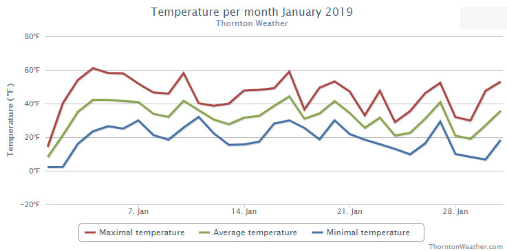
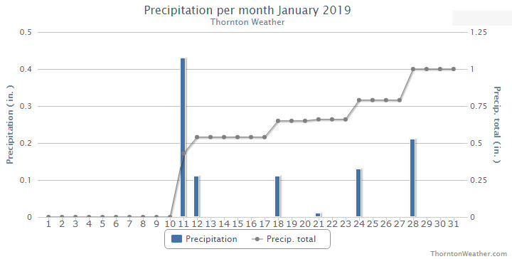
 As we begin the new year the winter chill begins to set in. While January can see its share of extremes, the month historically sees stable temperatures and is usually relatively dry.