Tag Archives: hurricane

Gustav ready to strike Monday AM

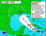
Satellite image of Gustav as of 5:00am MDT showing the storms predicted path.  Click for a larger version.
Satellite image of Gustav as of 5:00am MDT showing the storms predicted path. Click for a larger version.

Hurricane Gustav continues its march to the Louisiana coast Monday morning with landfall expected sometime between 5:00am and 7:00am MDT. At 5:00am MDT the eye of the hurricane was approximately 85 miles south of New Orleans and about 150 miles southeast of Layfayette moving at 16 mph.  Current tracks have it making landfall in the Terrebone / Lafourche areas, just to the east of New Orleans. 

**  Special Coverage:  Click here to view New Orleans radar  **

The good news, if there is any, is that Gustav has not strengthened as was originally expected.  The latest hurricane hunter aircraft report at 3:00am MDT reported sustained winds of 115 mph.  While that is still a category three storm, satellite observations show the storm is not as organized as it could be.  In fact, a station in southwest Pass Louisiana measured only 91mph as Gustav passed over it.  It is important to note that the greatest damage and danger associated with hurricanes is not the winds.  The severe rain, storm surge and the flooding associated with those present the greatest danger.  Rainfall of 6 to 12 inches can be expected and most notably storm surge of 10 to 14 feet. 
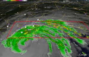
Radar image of Gustav showing current warnings and watches. Click for large version.

Also, one little known additional danger with hurricanes is that of the threat of tornadoes.  In fact, New Orleans and much of the surrounding area is under a Tornado Warning and some twisters have been reported by local law enforcement in Gulfport, MS.  Further, National Weather Service radar indicated the potential for tornadoes right near New Orleans in Jefferson Parish, Southern St. Charles Parish and Plaquemines Parish.

Here are a couple sites with webcams in Louisiana you may wish to check out:

Louisiana DOT

WWLTV.com

Gustav imagery via Google Earth

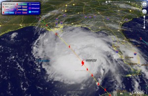
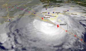
Below you will find the latest satellite imagery (as of 10:00am MDT) with tracking for Gustav generated with Google Earth.  For those that haven’t played with it, Google Earth is a very fun – and useful – program for any number of tasks.  Using it you can download place files with a wide variety of information including weather related items.  Here are a few links to get your started:

Hurricane Gustav image from Google Earth as of 10:00am MDT Sunday.
Hurricane Gustav image from Google Earth as of 10:00am MDT Sunday. Click on image for larger view.

Evacuations as Gulf Coast prepares for Hurricane Gustav

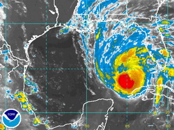
Satellite image of Hurrican Gustav as of 2:00am Sunday.

Residents along the Gulf Coast, particularly in Louisiana, are being ordered to evacuate as Hurricane Gustav bears down on the state.  With Hurricane Katrina still fresh on everyone’s mind, New Orleans is under a mandatory evacuation order and states all along the coast from Texas to Mississippi prepare for a possible hit from Gustav. 

National Hurricane Center forecasters were surprised by how quickly Gustav strengthened in recent days.  Within 24 hours the storm went from a tropical storm to a category 4 hurricane.  Gustav is currently a category 3 storm with sustained winds of 125 mph (gusting to 145 mph) and is expected to intensify in the next 12 hours, possibly reaching category 5 status for a time.  As of 3:00am MT Sunday the storm was 425 miles southeast of the mouth of the Mississippi River and heading northwest at 16 mph. 

By the time it makes landfall, forecasters expect it to be a category 3 storm, possibly a category 4.  The current forecast path for Gustav has it striking the central Louisiana coast with devastating results.  Storm surges of 18 to 25 feet on the eastern side of the hurricane are possible and 6 to 12 inches of rain may fall in Louisiana, southern Mississippi and southern Arkansas. 

John McCain and Sarah Palin await a determination on whether or not the RNC will proceed as scheduled.

In related news, the Republican National Committee was waiting to determine whether or not to proceed with its convention set to begin Monday it St. Paul, MN.  If it proceeds, it is unlikely President Bush would address  the delegates in person Monday as scheduled and would probably do so instead by video link.  John McCain in an interview with Chris Wallace of Fox News said, “It just wouldn’t be appropriate to have a festive occasion while a near-tragedy or a terrible challenge is presented in the form of a natural disaster.  So we’re monitoring it from day to day, and I’m saying a few prayers, too.”

For more information:

National Hurricane Center

2008 Republican National Convention

Hurricane season heats up with Gustav and Hanna

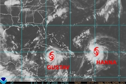
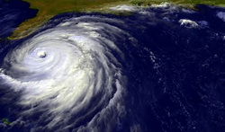
Satellite imagery of Gustav and Hanna.

Today, on the three year anniversary of Hurricane Katrina, preparations are underway along the Gulf Coast for the possibility that Tropical Storm Gustav will strike the region next week.  At 3:00am MDT Friday Gustav had tropical storm strength sustained winds of 65mph extending out 140 miles however it is fully expected to become a hurricane today.  It possibly could increase in intensity to a category four storm with 130mph winds by the time it makes landfall toward the beginng of next week. 

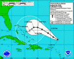
Gustav's current predicted track as of Friday morning.

It goes without saying that the storm presents a serious threat to life and property with landfall expected late Monday or early Tuesday.  The greatest danger lies between Houston, TX and Mobile, AL but anywhere along the Gulf Coast remains at risk for a hit from the storm.  State, federal and local officials are preparing for the worst as they should. Disaster declarations have been issued by Louisiana Governor Bobby Jindal and Texas Governor Rick Perry.  Mississippi Governor Haley Barbour has declared a state of emergency.  New Orleans Mayor Ray Nagin is expected to issue an evacuation order for the city, but it likely would not go into effect until Saturday.

Hanna's current predicted track as of Friday morning.

Tropical Storm Hanna, while less of a threat for the United States, also bears watching.  Hanna currently has winds of 50mph and should remain near those levels today but it is expected to become a hurricane in the coming days.  The storm this morning was located about 245 miles north-northeast of the northern Leeward Islands.  Hanna’s track at this point is uncertain.  A system currently over the Great Lakes could force Hanna to turn to the northeast thus missing any major land features.

Forecasters increase hurricane chances

NOAA says there is a greater chance for hurricanes in the coming months.

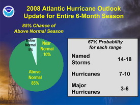
In their August update to hurricane season forecasts, experts at the National Oceanic and Atmospheric Administration (NOAA) have changed their predictions for the season and now expect a greater chance of hurricanes this season.  They are now predicting an “above normal” season with 14 to 18 named storms – up from the 12 to 16 they predicted in May.

The forecasters now believe there is an 85 percent chance that this above normal trend will take place (up from 65 percent in May). 

“Leading indicators for an above-normal season during 2008 include the continuing multi-decadal signal – atmospheric and oceanic conditions that have spawned increased hurricane activity since 1995 – and the lingering effects of La Niña,” said Gerry Bell, Ph.D. of NOAA’s Climate Prediction Center. “Some of these conditions include reduced wind shear, weaker trade winds, an active West African monsoon system, the winds coming off of Africa and warmer-than-average water in the Atlantic Ocean.”

The updated 2008 hurricane outlook.

Thus far in 2008 there have been five named storms and the most active hurricane period – August to October – is just now beginning.  Will this prediction hold true?  Unfortunateley forecasters have struggled in recent years with their predictions.  Last year NOAA predicted 10 hurricanes and only six formed. The year prior, 2006, nine hurricanes were forecasted by NOAA but only five formed.  In 2005, the year Hurricane Katrina devastated New Orleans in the worst U.S. natural disaster, the forecasts underestimated storm activity.