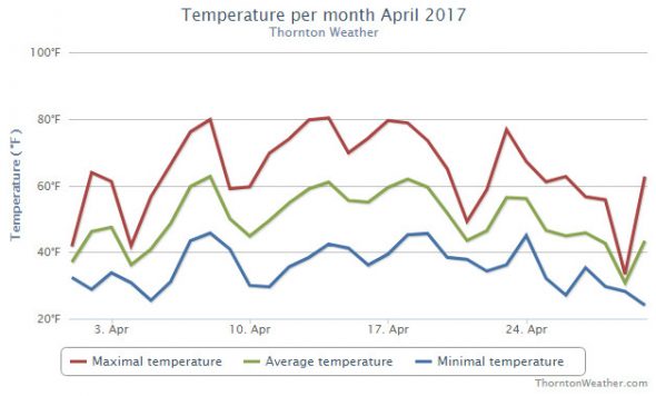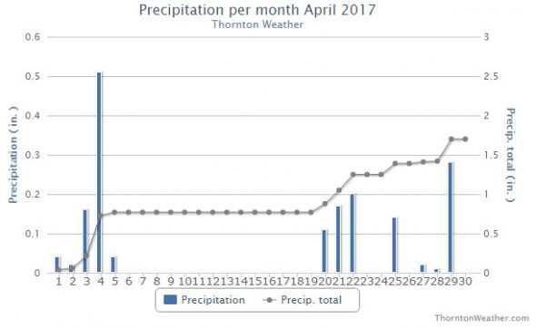
As we enter the latter half of April the weather history calendar starts to reflect shift in the type of weather events we see. There are still plenty of significant snowfall events. However spring severe weather starts to appear with greater frequency including heavy rain, hail and even tornadoes.
From the National Weather Service:
12-15
In 1927…snowfall totaled 8.5 inches in downtown Denver. Most of the snow fell on the 14th. Northwest winds were sustained to 27 mph during the storm.
13-15
In 1945…heavy snowfall totaled 9.8 inches in downtown Denver. Most of the snow…4.8 inches…fell on the 14th. Snow fell for a total of 53 consecutive hours. This was the second big snow in less than 2 weeks. The air mass was very cold for April. High temperatures of 21 degrees on the 14th and 32 degrees on the 15th were record low maximums for the those dates.
13-17
In 2001…a huge dust storm over southern and inner Mongolia during April 3rd through the 6th lifted desert dust into the jet stream. This dust cloud moved over metro Denver on the 13th and persisted through the 17th. The cloud created widespread haze…giving the sky a milkish cast due to the scattering of incoming solar radiation.
14-15
In 1873…north winds blew a gale during the afternoon on both days. Winds were brisk throughout each day.
In 1902…snowfall totaled 6.0 inches in downtown Denver. Most of the snow melted as it fell. Northeast winds were sustained to 20 mph.
In 1910…strong winds occurred on both days. Northeast winds were sustained to 52 mph on the 14th. North winds were sustained to 44 mph on the 15th.
In 1921…heavy snowfall and strong winds produced near- blizzard conditions in the city. Snowfall totaled 10.0 inches. Strong north winds sustained to 48 mph with gusts to 54 mph on the 15th produced drifts to several feet in depth. The heavy wet snow caused extensive damage to trees…utility poles…and buildings. Precipitation from the storm was 1.73 inches. Very heavy snow also fell in the foothills. At Silver Lake…in the mountains west of Boulder…95 inches of snow fell in 32.5 hours on the 14th and 15th.
In 1935…dense dust…apparently behind a dry cold front… Enveloped the city at 1:00 pm on the 14th and persisted through the night. The dust blew into the city on northeast winds sustained to 30 mph with gusts to 32 mph. By mid-morning on the 15th…the dust had become light and continued as such into the evening. North winds were sustained to only 13 mph on the 15th.
In 1999…a spring storm dumped heavy snow over portions of metro Denver. Nearly 2 feet of snow fell in the foothills with half a foot to a foot over western and southern suburbs. The heavy snow alleviated drought conditions and associated high fire danger that prevailed during much of the winter season. Snowfall totals included: 22 inches in Coal Creek Canyon…20 inches at Wondervu…19 inches at Genesee…17 inches near Evergreen and Nederland and at Idaho Springs and Tiny Town…14 inches at Georgetown…13 inches at Morrison…10 inches near Sedalia…9 inches in south Boulder… 8 inches at Highlands Ranch and Wheat Ridge…and 7 inches at Littleton and Parker. Only 3.4 inches of snow fell at the site of the former Stapleton International Airport. North- northwest winds gusted to 41 mph on the 15th at Denver International Airport.
15
In 1874…light snow developed around daybreak and became moderate to heavy by mid-morning and continued into the early evening. While most of the snow melted as it fell… Total precipitation from the melted snow was 0.95 inch. This would make the estimated snowfall nearly 10 inches.
In 1963…high winds were widespread across metro Denver. West winds gusted to 63 mph in Denver at Stapleton Airport with sustained winds of 35 mph and gusts to 70 mph in downtown Boulder. The winds caused extensive damage to buildings and other property. Visibility was briefly reduced to 1/2 mile in blowing dust at Stapleton Airport.
In 1998…another spring storm brought heavy snow to the foothills. Thirty to 40 vehicles were involved in accidents along I-70 near Georgetown. The combination of poor visibilities…slick roads…and careless drivers led to the multi-car pileups. Only minor injuries were reported. The accidents forced the closure of all of I-70’s eastbound lanes. Snowfall totals included 12 inches at Genesee and 10 inches at Aspen Springs…Chief Hosa…Georgetown…near Morrison…and on North Turkey Creek. Only 0.1 inch of snow fell at the site of the former Stapleton International Airport. East winds gusted to 30 mph at Denver International Airport.
In 2002…unseasonable warm weather resulted in two records being broken. The high temperature of 84 degrees was a record maximum for the date. The low temperature of 57 degrees was a record high minimum for the date.
15-16
In 1900…heavy rainfall totaled 2.33 inches. A trace of snow was mixed with the rain at times.
In 1950…thunderstorms and heavy rain behind a cold front produced 2.13 inches of rain in 24 hours at Stapleton Airport.
In 2003…a fast moving pacific storm system moved across Colorado allowing strong winds to develop over the eastern foothills and metro Denver. Northwest winds gusted to 59 mph at Denver International Airport late in the evening of the 15th.
15-17
In 1922…heavy snowfall totaled 9.0 inches in downtown Denver. Most of the snow…6.0 inches…fell on the 16th. This was the third major snow storm in a week. Northwest winds were sustained to 43 mph with gusts to 47 mph on the 15th.
16
In 1960…a wind storm struck all of metro Denver. Estimated wind gusts up to 80 mph were registered in Boulder. At Stapleton Airport sustained west-northwest winds over 50 mph with gusts as high as 70 mph produced some blowing dust. The high winds damaged buildings…power and telephone lines…and signs. Five people were injured in metro Denver as a result of the wind storm. Blowing dust reduced visibility at times. The winds were strong and gusty for most of the day.
16-17
In 1944…heavy snowfall totaled 7.5 inches in downtown Denver. Northwest winds were sustained to 18 mph on the 16th.
16-18
In 2009…a potent spring storm brought heavy snow to locations in and near the Front Range foothills. A deep easterly upslope produced nearly 5 feet of snow in parts of the foothills. The heavy snow resulted in the closure of Interstate 70…from Golden west to Vail…for approximately 16 hours. The heavy snow snapped power lines in Evergreen and Nederland. The ensuing outages affected 14200 residents. In the Front Range foothills…storm totals included: 56 inches…3 miles south of Rollinsville; 54 inches…3 miles southeast of Pinecliffe…43 inches at Aspen Springs…42 inches at Evergreen…38 inches near conifer; 37 inches at St. Mary’s glacier…and 34 inches near Nederland. Along the urban corridor and Palmer Divide…the heaviest snow occurred above 5500 feet on the 17th. Storm totals included: 22 inches…8.5 miles southwest of Franktown; 18 inches…10 miles south-southeast of Buckley Air Force Base; 17 inches near Cherry Creek and 7 miles south of Sedalia… 16 inches…6.5 miles southwest of Castle Rock; 15 inches near Beverly Hills; 12 inches near Highlands Ranch and Lafayette…with 11 inches in Broomfield. Elsewhere storm totals ranged from 4 to 10 inches. Officially…only 2.6 inches of snow was observed at Denver International Airport. The 24-hr precipitation for the day however was 1.16 inches… Which established a new record for April 17th.
Continue reading April 15 to April 21: This week in Denver weather history


