Tag Archives: April weather

April 5 to April 11: This week in Denver weather history

This Week in Denver Weather History

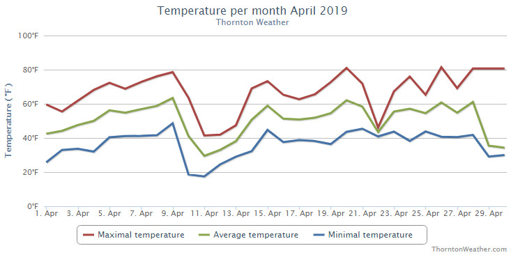
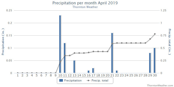
An incredibly busy week on the Denver weather history calendar as we see below.  Thunderstorms, blizzards, tornadoes, hurricane force winds and more have all been seen during this week in Denver weather history.

From the National Weather Service:

2-5

In 1918…snowfall totaled 12.4 inches over downtown Denver. Most of the snow fell on the 3rd and 4th. Temperatures were in the 20`s and 30`s. Northwest winds were sustained to 24 mph on the 2nd.

3-5

In 1996…the foothills west of Denver received 6 to 8 inches of new snow. Only 0.8 inch of snow fell at the site of the former Stapleton International Airport…along with some freezing drizzle on the 4th and 5th. North-northeast winds gusted to 30 mph at Denver International Airport on the 3rd.

3-6

In 1898…snowfall totaled 8.7 inches in downtown Denver over the 4 days. Northeast winds were sustained to 48 mph with gusts as high as 60 mph on the 3rd.

In 1983…a prolonged heavy snow storm blanketed the area along with very cold temperatures. The greatest amounts of snow fell in the foothills where 24 to 42 inches were measured. A foot of snow fell in Boulder. Snow fell for 50 consecutive hours at Stapleton International Airport on the 3rd through the 5th with a total snowfall of 8.8 inches and a maximum accumulation on the ground of 6 inches on the 5th. In Denver…the mercury failed to rise above freezing for 3 consecutive days…on the 4th…5th… And 6th…for the first time ever in April. Five daily temperature records were set from the 4th through the 6th. Record low temperatures of 12 degrees occurred on the 5th with 7 degrees on the 6th. Record low maximum temperatures of 25 degrees occurred on the 4th…27 degrees on the 5th… And 28 degrees on the 6th.

4-5

In 1900…rain changed to heavy snow and totaled 7.8 inches in downtown Denver overnight. A thunderstorm on the 4th produced hail. Precipitation totaled 1.50 inches.

In 1911…north to northwest winds were sustained to 42 mph on the 4th and to 41 mph on the 5th.

In 2002…a whitish-colored haze engulfed metro Denver on both days. The haze was the result of a huge wind storm that kicked up dust and sand from the Gobi desert in Mongolia and China during the latter half of March. Westerly winds aloft transported the dust cloud across the Pacific Ocean and over the western united states…depositing some of it on Colorado.

In 2009…a blizzard developed over the northeast plains of Colorado. Most of the urban corridor was spared from the blizzard…with the exception of eastern Adams and eastern Arapahoe counties. The combination of strong wind and heavy snow snapped 14 power lines along State Highway 36… Near Strasburg. In Arapahoe County…7 poles were snapped in Bennett. Interstate 70 was closed in both directions east of Denver. At Denver International Airport…a peak wind gust of 63 mph was observed from the north…breaking the previous record of 62 mph established in 1986. Officially…only 0.3 inches of snowfall was measured at Denver International Airport.

4-7

In 1909…post-frontal rain changed to heavy snow on the afternoon of the 4th and continued through mid-morning of the 7th. Total snowfall was 18.7 inches…but most of the snow…14.0 inches… Fell from 6:00 pm on the 4th to 6:00 pm on the 5th. North to northeast winds were sustained to 32 mph on the 4th and to 30 mph on the 7th. Total precipitation from the storm was 1.78 inches.

5

In 1873…a heavy rain and hail shower in the afternoon changed to snow…and accumulated to 6 inches on the streets at 9:00 pm. Precipitation (rain and melted snow) totaled 0.56 inch.

In 1925…southeast winds were sustained to 46 mph with gusts to 50 mph. This was the strongest wind of the month that year.

In 1950…a well-developed dust devil was observed 4 to 5 miles south-southwest of Stapleton Airport for about 8 minutes.

In 1977…the earliest date of the last freeze of the season occurred when the temperature dipped to a low of 31 degrees.

In 1988…a wind gust to 74 mph was recorded at Rollinsville. West winds gusted to 35 mph at Stapleton International Airport.

In 1990…a heavy… Wet snow fell in many areas in and along the Colorado Front Range. Snowfall amounts of 4 to 7 inches were common around the Boulder area with lesser amounts elsewhere. Only 2.0 inches of snow fell at Stapleton International Airport where north winds gusted to 28 mph. Icy roads contributed to numerous fender-benders and a 20-vehicle pileup near the junction of I-70 and I-25 in the city.

In 2000…high winds developed in the Front Range foothills… From about I-70 northWard. Peak wind gusts included: 83 mph at the National Center for Atmospheric Research in Boulder…75 mph near Louisville… And 70 mph at the National Wind Technology Center…south of Boulder. West winds gusted to 41 mph at Denver International Airport.

In 2005…a surface low pressure center deepened over eastern Colorado and produced damaging high winds across metro Denver. The strong wind gusts ranging from 50 to 70 mph damaged roofs and fences. Cross-winds blew several empty semI-trailers on their sides along I-70 and I-76 east of Denver. Peak north wind gusts included: 60 mph near Bennett and Keenesburg…59 mph near Brighton… And 53 mph at Denver International Airport. Over the Palmer Divide south of Denver…the high winds combined with heavy snow to produce blizzard conditions. Snowfall accumulations ranged from 3 to 8 inches over eastern Douglas and western Elbert counties. Snowfall totals included: 8 inches at Sedalia…4 inches near Castle Rock… And 3.5 inches near Franktown.

5-6

In 1939…3.0 inches of snow fell in downtown Denver. North winds were sustained to 34 mph on the 5th and to 26 mph on the 6th. The strong winds caused considerable drifting of snow. Several highways leading into the city were closed during the height of the storm due to poor visibility. Streets and highways became coated with ice in places. The temperature dipped to 11 degrees early on the 6th. This was the coldest reading of the month that year. Most vegetation was not far enough advanced to be injured by the cold temperatures…although a few buds froze on early shrubbery.

In 1949…strong winds in Boulder caused limited minor damage. West-northwest winds were sustained to 24 mph with some higher gusts at Stapleton Airport.

5-7

In 1916…rain changed to snow behind a cold front on the 5th and totaled 4.5 inches in the city. A thunderstorm produced snow on the 6th. North winds were sustained to 35 mph with gusts to 38 mph on the 7th.

6

In 1904…northwest winds were sustained to 40 mph with gusts to 48 mph.

In 1919…post-frontal rain changed to snow but totaled only 0.1 inch. However…north winds were sustained to 40 mph with gusts to 44 mph in the city.

In 1954…a vigorous cold front produced northeast winds at 38 mph with gusts as high as 50 mph. The strong winds briefly reduced visibility to 1 1/2 miles in blowing dust at Stapleton Airport.

In 1972…wind gusts to 68 mph were recorded at the National Bureau of Standards in Boulder. Winds peaked to 54 mph in downtown Boulder. Minor damage was reported. Northwest winds gusted to 44 mph at Stapleton International Airport where the strong Chinook winds warmed the temperature to a high of 80 degrees…equaling the record maximum for the date.

6-7

In 1872…rain changed to snow overnight. Snow with high north winds continued all day on the 7th. Precipitation (rain and melted snow) totaled 0.50 inch. Due to problems on the lines…the morning weather report was not sent by telegraph until 3:10 pm and the midnight report was not sent at all.

In 1957…heavy snowfall totaled 6.6 inches at Stapleton Airport where north winds gusted to 46 mph. This was the second heavy snow event in less than 4 days.

In 1969…winds gusting as high as 50 to 60 mph caused only light damage along the eastern foothills. The strong winds contributed to the spread of a forest fire near Boulder. Sustained winds of 25 mph with gusts to 53 mph were recorded in Boulder. Southwest winds gusted to 38 mph on the 6th and 44 mph on the 7th at Stapleton International Airport.

In 1980…high winds howled along the foothills each day. A wind gust to 72 mph was recorded in Lakewood. The strong winds blew a camper top off a pickup truck in Denver. At Stapleton International Airport…west winds gusted to 41 mph on both days.

In 1998…a spring storm brought a mix of snow and thunder to metro Denver…the foothills… And Palmer Divide. Conifer and Elizabeth both measured 4 inches of new snow. On the 6th…only 0.1 inch of snow fell at the site of the former Stapleton International Airport where thunder was heard on both days. Precipitation totaled 0.60 inch at Denver International Airport where west winds gusted to 43 mph on the 6th.

6-8

In 1973…a major spring snow storm dumped 11.6 inches of snowfall over metro Denver. North wind gusts of 30 to 35 mph produced some blowing snow. Most of the heavy wet snow… 10.1 inches…fell on the 7th when temperatures remained in the 20`s. Snow accumulated on the ground to a maximum depth of 9 inches. Low temperature of 5 degrees on the 8th was a new record minimum for the date and the lowest for so late in the season.

Continue reading April 5 to April 11: This week in Denver weather history

Thornton’s April 2020 weather preview: Winter, spring and summer all in one month

Thornton's April weather previewApril marks a transition between winter and summer for most of the country but for Denver it is especially true as we can see a stunning variety of weather.

The proverbial April showers are certainly a possibility for Denver. Snow? Tornadoes? Thunderstorms? You bet – all can happen!

For good measure throw in a chance for hail and even dust storms and April gives every type of weather condition you could like – or hate.

March 29 to April 4: This week in Denver weather history

This Week in Denver Weather History

This week in Denver weather history is notable for the variety of conditions that can be experienced this time of year.  From hurricane force winds and heavy snow to more typical spring severe weather like tornadoes, all can be experienced this time of year.

From the National Weather Service:

27-29

In 1948…high winds raked Boulder. A wind gust to 75 mph was recorded at Valmont. Sustained winds in excess of 35 mph were estimated in Boulder. Minor damage was reported.

In 1961…heavy snowfall totaled 9.5 inches at Stapleton Airport over the 3 day period. Most of the snow…5.3 inches…fell on the 28th. Winds were generally light and gusted to only 22 mph from the north.

28-29

In 1891…rain changed to snow and totaled 9.7 inches in the city. Northeast winds were sustained to 12 mph with gusts to 28 mph on the 28th.

In 1910…a strong cold front brought much wind…rain…and and snow to the city. Rain on the 28th changed to snow early on the 29th. Snowfall totaled only 2.8 inches…but north winds were sustained to 50 mph on the 29th. Precipitation from the storm totaled 0.96 inch.

In 1994…moist upslope winds combined with an upper level system to dump 5 to 7 inches of snow along the eastern foothills and across metro Denver. Snowfall totaled 6.3 inches at Stapleton International Airport where northeast winds gusted to 39 mph. Thirteen inches of new snow were measured at the Eldora ski area west of Boulder.

28-30

In 1949…a major winter storm dumped 11.3 inches of snow over downtown Denver. Snowfall totaled 10.4 inches at Stapleton Airport. North to northeast winds were sustained to 17 mph.

In 1985…a slow moving snow storm moved across the state. Denver received only 4.0 inches of snowfall with amounts in the foothills totaling 1 to 2 feet. Still…this was enough snow in Denver to cause flight delays of up to 6 hours at Stapleton International Airport on the night of the 29th. East winds gusted to 28 mph on the 28th.

29

In 1887…west winds sustained to 44 mph warmed the temperature to a high of 62 degrees.

In 1921…post-frontal northeast winds were sustained to 46 mph with gusts to 52 mph.

In 1925…southeast winds were sustained to 46 mph with gusts to 48 mph. These were the strongest winds of the month that year. The winds warmed the temperature to a high of 72 degrees.

In 1934…a construction worker was killed by lightning as he walked with a shovel on his shoulder along Cherry Creek in the city. The thunderstorm produced light rain.

In 1967…a southwest wind gust to 52 mph was recorded at Stapleton International Airport. The warm Chinook winds warmed the temperature to 79 degrees equaling the record for the date.

In 1979…a tornado touched down 4 miles southwest of Parker… But caused no reported damage.

In 1998…four children attending a birthday party in Denver were injured when an apparent dry microburst produced a sudden strong wind gust which blew an inflatable playhouse they were occupying into a neighbor’s yard. The playhouse scraped the roof of the host’s two-story house…then landed in the adjoining yard. The children were treated for minor head injuries and cuts.

29-30

In 1938…overnight heavy snowfall was 6.3 inches over downtown Denver.

In 1982…strong winds buffeted metro Denver…breaking windows and damaging roofs. Wind gusts to 90 mph were recorded in Boulder and 51 mph at Stapleton Airport. The strong winds flattened a condominium under construction in Lakewood.

In 1991…1 to 6 inches of snow fell across metro Denver with the heaviest snow confined to the foothills. Six inches of snow was recorded at South Platte in the foothills southwest of Denver and 3 inches at Castle Rock. Snowfall totaled only 0.7 inch at Stapleton International Airport where northeast winds gusted to 33 mph on the 29th.

29-31

In 1970…snowfall totaled 6.0 inches at Stapleton International Airport. Heavy snow accumulation in Boulder on the 29th caused the collapse of a carport at an apartment building…damaging 11 automobiles. Northeast winds gusted to 24 mph at Stapleton International Airport.

30

In 1895…rain changed to sleet…then snow…and totaled 8.0 inches in downtown Denver. Strong post-frontal northeast winds were sustained to 48 mph with gusts to 61 mph. Temperatures hovered around 30 degrees all day.

In 1968…microburst winds associated with virga and brief light rain gusted to 46 mph at Stapleton International Airport.

In 1983…winds gusted to 82 mph at the National Center for Atmospheric Research in Boulder with peak gusts of 70 to 80 mph in the foothills. Minor damage occurred at a construction site and to some homes in Boulder. West winds gusted to 39 mph at Stapleton International Airport.

30-31

In 1896…heavy snowfall totaled 7.5 inches in downtown Denver. Northwest winds gusted to 26 mph.

In 1897…rain changed to snow during the early morning of the 30th and totaled 6.2 inches before ending during the late morning of the 31st. Northwest winds were sustained to 35 mph with gusts to 46 mph.

In 1929…heavy snowfall of 7.0 inches was recorded over downtown Denver. Northwest winds were sustained to 23 mph on the 30th.

In 1953…heavy snowfall totaled 8.6 inches at Stapleton Airport where northeast winds gusted to 23 mph.

In 1955…a vigorous cold front produced north winds at 40 mph with gusts as high as 54 mph at Stapleton Airport. Rain and snow showers and blowing dust accompanied the front. Snowfall totaled only 0.1 inch at Stapleton Airport on the 31st.

In 1988…snow began falling on the afternoon of the 30th and continued through the 31st…burying metro Denver. Twelve to 18 inches of snow fell in the foothills to the west of Denver and Boulder with 6 to 12 inches across the rest of metro Denver. The storm disrupted aircraft operations at Stapleton International Airport where snowfall totaled 7.1 inches and north winds gusting to 32 mph reduced the visibility to less than 1/4 mile at times…causing air traffic delays of 2 to 3 hours.

In 2000…heavy snow once again developed over the foothills and the higher terrain to the south of metro Denver. Snowfall totals from the storm included: 16 inches atop Squaw Mountain…15 inches near Rollinsville…13 inches near Evergreen…12 inches near Morrison…11 inches in Coal Creek Canyon…10 inches near Blackhawk and in Eldorado Springs…9 inches at Ken Caryl Ranch and larkspur… And 8 inches near Elizabeth. Snowfall totaled only 4.1 inches at the site of the former Stapleton International Airport. North winds gusted to 32 mph at Denver International Airport on the 30th.

In 2005…a strong spring storm intensified over the eastern plains of Colorado and produced near-blizzard conditions to the east and southeast of Denver overnight. North to northwest winds from 20 to 35 mph with gusts to 50 mph produced extensive blowing snow and caused near zero visibilities at times and snow drifts from 2 to 4 feet in depth. Snowfall amounts included: 12 inches near Bennett…8 inches around Castle Rock… 7 inches near Sedalia…and 6 inches near Parker. Only 0.3 inch of snow was reported at Denver Stapleton. At Denver International Airport…north winds gusted to 37 mph on the 30th and 36 mph on the 31st.

In 2014…on the evening of the 30th…high based showers and thunderstorms produced microburst winds over northern Jefferson…eastern Boulder and southwest weld counties. Peak wind reports included: 77 mph at white ranch open space; 72 mph…2 miles north of Longmont; 67 mph near Erie and firestone; 60 mph near mead and 59 mph…5 miles northwest of Henderson; with 53 mph at Denver International Airport. The wind downed power lines in Weld County which sparked a small fire. High winds then developed in the Front Range foothills and urban corridor through the morning of the 31st. Peak wind gusts included: 98 mph near gold hill; 77 mph near Eldorado Springs; 61 mph at Centennial Airport; 59 mph at Buckley Air Force Base; with 44 mph at Denver International Airport.

31

In 1873…high winds damaged buildings in the city. Northwest winds with sustained velocities to near 40 mph blew from 9:00 am until sunset.

In 1937…north to northeast winds sustained to 25 mph with gusts to 32 mph produced a light dust storm in the city during the afternoon.

In 1971…wind gusts to 92 mph were recorded in the south hills area of Boulder. At the National Bureau of Standards in Boulder sustained winds of 46 mph with gusts to 83 mph were measured. Damage was minor. Northwest winds gusted to 41 mph at Stapleton International Airport.

In 1983…high winds with gusts to 70 mph in Boulder caused minor damage.

31-1

In 1876…heavy snow began during the night and lasted all day on the 31st and through the morning of the 1st. The average depth of snow fall was 10 to 12 inches…but strong winds whipped the snow into drifts of 8 to 10 feet deep on the streets of the city. Precipitation from the storm was 1.03 inches on the 31st and 0.37 inch on the 1st.

In 1891…heavy moist snowfall totaled 18.0 inches in the city. Northeast winds were sustained to 20 mph with gusts to 24 mph on the 31st.

In 1936…northeast winds sustained to 21 mph produced a light dust storm in the city.

In 1975…a major storm dumped 9.3 inches of snowfall at Stapleton International Airport where northwest winds gusted to 41 mph. Rain changed to snow on the afternoon of the 31st…reducing the visibility to as low as 1/8 mile. Snow continued all day on the 1st and accumulated to a depth of 8 inches on the ground. The minimum temperature of 10 degrees on the 1st set a new record low for the date.

Continue reading March 29 to April 4: This week in Denver weather history

April 2019 weather recap: Warmer, drier than normal for Thornton

The month of April had the usual, inconsistent weather conditions we expect from the month. Thornton enjoyed everything from spring-like days with mild temperatures to a healthy round of snow and cold.

The month started out mild with seven of the first nine days of the month seeing above normal temperatures and pleasant conditions. A cold front and storm system moved in on the 10th though and brought about significant changes for a few days and our first snow of the month.

Warmer weather returned though and on the 20th we recorded our first 80 degree day of the year. Showers and thunderstorms on the 21st brought some much-needed rain then we dried back out for the next six days. We saw a couple more 80+ degree days then the final two days chilled things out and delivered a bit more snow.

Thornton’s overall average temperature for the month came in at 49.6 degrees. This was a good bit above Denver’s long-term April average of 47.4 degrees. Out at DIA where the Mile High City’s official measurements are kept, the average temperature was similar with 49.1 degrees.

Temperatures in Thornton ranged from a high of 81.4 degrees on the 26th down to a low of 17.5 degrees on the 11th. Denver saw a high reading of 80 degrees on the 20th and a low of 17 on the 11th.

In terms of precipitation, Denver averages 1.71 inches during April. Both Thornton and Denver fell short of that mark with 0.78 inches and 1.25 inches in their rain buckets respectively.

Snowfall in Thornton was respectable with 8.1 inches of the white stuff. Denver was well short of that with 3.5 inches. April averages 6.8 inches so while Thornton was above that, Denver was below.

Click here to view Thornton’s April 2019 climate report.

Thornton, Colorado's April 2019 temperature summary. (ThorntonWeather.com)
Thornton, Colorado’s April 2019 temperature summary. (ThorntonWeather.com)
Thornton, Colorado's April 2019 precipitation summary. (ThorntonWeather.com)
Thornton, Colorado’s April 2019 precipitation summary. (ThorntonWeather.com)
CLIMATE REPORT
NATIONAL WEATHER SERVICE DENVER/BOULDER CO
913 AM MDT WED MAY 1 2019

...................................

...THE DENVER CO CLIMATE SUMMARY FOR THE MONTH OF APRIL 2019...

CLIMATE NORMAL PERIOD 1981 TO 2010
CLIMATE RECORD PERIOD 1872 TO 2019

WEATHER         OBSERVED          NORMAL  DEPART  LAST YEAR`S
                 VALUE   DATE(S)  VALUE   FROM    VALUE  DATE(S)
                                          NORMAL
................................................................
TEMPERATURE (F)
RECORD
 HIGH              90   04/30/1992
 LOW               -2   04/02/1975
HIGHEST            80   04/20                         83  04/29
LOWEST             17   04/11                         21  04/06
                        04/10
AVG. MAXIMUM     62.7              61.5     1.2     63.2
AVG. MINIMUM     35.6              33.3     2.3     32.5
MEAN             49.1              47.4     1.7     47.8
DAYS MAX >= 90      0               0.0     0.0        0
DAYS MAX <= 32      0               0.3    -0.3        0
DAYS MIN <= 32     10              13.0    -3.0       16
DAYS MIN <= 0       0               0.0     0.0        0

PRECIPITATION (INCHES)
RECORD
 MAXIMUM         8.24   1900
 MINIMUM         0.03   1963
TOTALS           1.25              1.71   -0.46     0.86
DAILY AVG.       0.04              0.06   -0.02     0.03
DAYS >= .01         9               9.1    -0.1        8
DAYS >= .10         2               4.5    -2.5        4
DAYS >= .50         1               0.9     0.1        0
DAYS >= 1.00        0               0.5    -0.5        0
GREATEST
 24 HR. TOTAL    0.82   04/21 TO 04/21           04/21 TO 04/21

SNOWFALL (INCHES)
RECORDS
 TOTAL            3.5               6.8
RECORD APRIL     33.8    1933

DEGREE_DAYS
HEATING TOTAL     469               529     -60      509
 SINCE 7/1       5805              5731      74     5250
COOLING TOTAL       0                 1      -1        2
 SINCE 1/1          0                 1      -1        2

FREEZE DATES
RECORD
 EARLIEST     09/08/1962
 LATEST       06/08/2007
EARLIEST                        10/07
LATEST                          05/05
.................................................................

WIND (MPH)
AVERAGE WIND SPEED              10.3
RESULTANT WIND SPEED/DIRECTION   0/078
HIGHEST WIND SPEED/DIRECTION    44/310    DATE  04/21
HIGHEST GUST SPEED/DIRECTION    55/280    DATE  04/28

SKY COVER
POSSIBLE SUNSHINE (PERCENT)   MM
AVERAGE SKY COVER           0.60
NUMBER OF DAYS FAIR            2
NUMBER OF DAYS PC             19
NUMBER OF DAYS CLOUDY          9

AVERAGE RH (PERCENT)     56

-  INDICATES NEGATIVE NUMBERS.
R  INDICATES RECORD WAS SET OR TIED.
MM INDICATES DATA IS MISSING.
T  INDICATES TRACE AMOUNT.

April 2019 top shots: Monthly photo slideshow

April 7, 2019 - A stunning sunset in Thornton to end the day. (Michelle Jones)
April 7, 2019 – A stunning sunset in Thornton to end the day. (Michelle Jones)

April can be a tricky month weather-wise with everything from mild temperatures to snow to severe weather being possible.  The good thing about that is that it provides plenty of chances for great photos!

April marks a transition between winter and summer for most of the country but for Denver it is especially true as we can see a stunning variety of weather.

The proverbial April showers are certainly a possibility for Denver. Snow? Tornadoes? Thunderstorms? You bet – all can happen!

Throw in our usual wildlife plus the wide variety of birds that return to the Centennial State for the spring and summer and there is a lot going on.

  • Slideshow updated April 29, 2019. 
  • To learn more about how to send your photo to us for inclusion in the slideshow, see below the slideshow.

Showcasing images captured by ThorntonWeather.com readers as well as some of our own, our monthly slideshow covers the entire gamut of weather-related imagery.

Sunsets, sunrises, wildlife and of course every type of weather condition are vividly depicted in images captured from yours and our cameras.

[flickr_set id=”72157708233990884″]

What is missing in the slideshow above?  Your photo!

Our monthly photo slideshow is going to feature images that we have taken but more importantly images that you have captured.  The photos can be of anything even remotely weather-related.

Landscapes, current conditions, wildlife, pets, kids.  Whimsical, newsy, artsy.  Taken at the zoo, some other area attraction, a local park, a national park or your backyard.  You name it, we want to see and share it!

Images can be taken in Thornton, Denver or anywhere across the extraordinary Centennial State.  We’ll even take some from out of state if we can tie it to Colorado somehow.

We’ll keep the criteria very open to interpretation with just about any image eligible to be shown in our slideshows.

What do you win for having your image in our slideshow?  We are just a ‘mom and pop’ outfit and make no money from our site so we really don’t have the means to provide prizes.  However you will have our undying gratitude and the satisfaction that your images are shared on the most popular website in Thornton.

To share you images with us and get them included in the slideshow just email them to us or share them with ThorntonWeather.com on any of the various social media outlets.  Links are provided below.

So come on, get those camera’s rolling!

April 2019 - Top Shots 2

2018 – 2019 seasonal snowfall numbers continue to improve

Thornton, Colorado seasonal snowfall totals as of April 11, 2019. Click for larger image. (ThorntonWeather.com)

Thornton hasn’t had any truly big time snows this year but we have managed a number of respectable ones and that shows in our seasonal snow totals.

As of today, Thornton has received 49.1 inches of snow for the season. That is just slightly below our running 13 year seasonal average of 53.1 inches.

As for Denver, officially, the Mile High City has recorded 43.2 inches thus far this season as measured at DIA. The all-time seasonal average snowfall for Denver is 57.1 inches (55.3 inches 30 year average) so there is still ground to make up there to get near average.

With half of April and all of May to go, there’s still plenty of time to add to those numbers.

In case you were wondering… The average date of Denver’s last snowfall is April 27th. The latest? June 12, 1947 when a trace was recorded. The latest measurable snowfall was 0.4 inches on June 1, 2919.

Thornton’s April 2019 weather preview: Three seasons wrapped into one

Thornton's April weather previewApril marks a transition between winter and summer for most of the country but for Denver it is especially true as we can see a stunning variety of weather.

The proverbial April showers are certainly a possibility for Denver. Snow? Tornadoes? Thunderstorms? You bet – all can happen!

For good measure throw in a chance for hail and even dust storms and April gives every type of weather condition you could like – or hate.

April 29 to May 5: This week in Denver weather history

This week in Denver weather history
April 29 to May 5: This week in Denver weather history

May can bring a variety of conditions from snow and cold to severe thunderstorms and flooding rains. Looking back at this week in Denver weather history we see where all of those events have made an appearance in our past.

From the National Weather Service:

28-29

In 1950…snowfall totaled 6.3 inches at Stapleton Airport…but only 3.5 inches over downtown Denver.

In 1960…heavy snow fell at Stapleton Airport where 8.6 inches of snow were measured. North winds gusted to 38 mph. Most of the snow…6.9 inches…fell on the 29th.

29

In 1898…apparent thunderstorm winds were sustained from the southwest to 58 mph with gusts to 66 mph.

In 1909…north winds were sustained to 44 mph behind an apparent cold front. These were the strongest measured winds of the month that year.

In 1962…heavy snowfall totaled 6.4 inches at Stapleton Airport where northeast winds gusted to only 17 mph. Snow fell all day…but the most on the ground was only 1 inch due to melting.

In 1991…two men were struck by lightning while golfing in cherry hills just south of Denver. The two received only minor burns. Shortly afterward…lightning struck a home in cherry hills village several times…leaving numerous holes in the roof. No injuries were reported.

In 1993…localized strong winds occurred at Jefferson County Airport near Broomfield where gusts to 63 mph were recorded. The strong winds were the result of a probable microburst.

In 2000…several severe thunderstorms producing large hail and destructive winds rumbled across northern metro Denver. Thunderstorm wind gusts reached 81 mph near Hudson with hail as large as 3/4 inch in diameter at Longmont. Several homes and vehicles sustained damage. The strong winds uprooted trees and downed utility poles…causing scattered outages. Lightning sparked a house fire in Boulder. The fire damaged a portion of the roof and a bedroom on the third floor. Thunderstorm winds gusted to 53 mph at Denver International Airport.

In 2003…lightning struck a chimney at a residence in Hiwan in Evergreen…sending stones flying as far as 150 feet. Electrical equipment in some nearby homes also failed. Damage to the residence…in addition to electrical equipment…was estimated at 100 thousand dollars. Severe thunderstorms produced large hail to 1 inch in diameter near Hudson and Sedalia and to 3/4 inch near Parker. Hail as large as 1 3/4 inches was measured 9 miles north of Sedalia.

In 2014…high winds occurred east of Interstate 25. Peak wind gusts included: 71 mph just north of Strasburg; 68 mph at Denver International Airport; 62 mph near Elizabeth; 58 mph at Front Range Airport in Watkins and 11 miles east of Parker.

29-30

In 1964…several weeks of dry weather and windy conditions across the Great Plains to the east caused noticeable suspended dust to invade metro Denver. At Stapleton International Airport east winds gusted to 28 mph and visibility was reduced to 5 miles.

In 1989…a late season snowstorm dropped 2 to 4 inches of snow across metro Denver with 6 to 12 inches in the foothills. Snowfall totaled 3.9 inches at Stapleton International Airport where northeast winds gusted to 23 mph and the greatest snow depth on the ground was 2 inches due to melting.

In 1991…a pacific storm dumped heavy wet snow across metro Denver. The foothills were hit the hardest where snowfall amounts ranged from 16 inches at Evergreen to 5 inches at Idaho Springs. Lower elevations of metro Denver received 5 to 9 inches of snowfall with 5 inches in Boulder and 7.0 inches at Stapleton International Airport where northeast winds gusted to 25 mph. The weight of the snow caused power lines to fall and tree limbs to snap…producing power outages in parts of Denver…Aurora…and Westminster.

In 1999…heavy snow fell overnight in the foothills above 7500 feet elevation. Snowfall totals included: 13 inches near Rollinsville…10 inches near Evergreen…8 inches at Blackhawk and Nederland…and 7 inches at Conifer. Only rain fell across the city with 2.13 inches recorded at Denver International Airport.

29-2

In 1954…a major storm dumped 10.1 inches of snowfall at Stapleton Airport. Most of the snow…7.5 inches…fell on the 29th and 30th. The maximum snow depth on the ground was 5 inches on the 30th due to melting. No strong winds accompanied the storm.

30

In 1896…northwest winds were sustained to 55 mph with gusts as high as 64 mph in the city.

In 1960…the minimum temperature dipped to 22 degrees at Stapleton Airport. The sub-freezing cold damaged fruit trees and some other crops in the area.

In 1967…west winds gusted to 51 mph at Stapleton International Airport. Winds were strong and gusty across all of metro Denver.

In 1972…hail 1/2 to 3/4 inches in diameter fell at Stapleton International Airport. Northwest winds gusted to 35 mph.

In 1980…a cold air funnel touched down several times near Louisville.

In 1983…mothball-size hail fell in Wheat Ridge.

In 1992…the all-time highest recorded temperature in April… 90 degrees…occurred. This is also the earliest 90 degree reading for the season. In addition…the temperature dipped to a low of only 56 degrees…setting a record high minimum for the date.

In 1995…hail…up to 3/4 inch in diameter…fell at Denver International Airport. The hail was soft…lasted for only 8 to 10 minutes…and caused no damage.

In 2002…drought conditions started to have an effect on greater metro Denver. April…normally the third snowiest month of the year in Denver averaging just over 9 inches of snow…ended with only a trace of snow…ranking the month… Along with previous Aprils…the 2nd least snowiest on record. The month ended with only 0.23 inch of liquid precipitation making the month the 3rd driest on record. Mountain snowpack was less than half of normal for this time of year. A statewide drought emergency was declared by the governor.

In 2003…a small tornado touched down 10 miles east of Hudson… But did no damage. Hail as large as 3/4 inch in diameter fell in Aurora near Cherry Creek.

In 2004…post-frontal upslope flow produced light snowfall across metro Denver. Snowfall was 4.0 inches at Denver Stapleton…while the temperature hovered in the lower 30’s all day. The high temperature was only 33 degrees…a record low maximum for the date. The low temperature of 30 degrees was not a record. North winds gusted to 20 mph at Denver International Airport.

Continue reading April 29 to May 5: This week in Denver weather history

April 2018 top shots: Monthly photo slideshow

A Fox vixen hangs out on a pleasant spring evening. (J Martin)

April can be a tricky month weather-wise with everything from mild temperatures to snow to severe weather being possible.  The good thing about that is that it provides plenty of chances for great photos!

April marks a transition between winter and summer for most of the country but for Denver it is especially true as we can see a stunning variety of weather.

The proverbial April showers are certainly a possibility for Denver. Snow? Tornadoes? Thunderstorms? You bet – all can happen!

Throw in our usual wildlife plus the wide variety of birds that return to the Centennial State for the spring and summer and there is a lot going on.

  • Slideshow updated April 29, 2018. 
  • To learn more about how to send your photo to us for inclusion in the slideshow, see below the slideshow.

Showcasing images captured by ThorntonWeather.com readers as well as some of our own, our monthly slideshow covers the entire gamut of weather-related imagery.

Sunsets, sunrises, wildlife and of course every type of weather condition are vividly depicted in images captured from yours and our cameras.

[flickr_set id=”72157665882943537″]

What is missing in the slideshow above?  Your photo!

Our monthly photo slideshow is going to feature images that we have taken but more importantly images that you have captured.  The photos can be of anything even remotely weather-related.

Landscapes, current conditions, wildlife, pets, kids.  Whimsical, newsy, artsy.  Taken at the zoo, some other area attraction, a local park, a national park or your backyard.  You name it, we want to see and share it!

Images can be taken in Thornton, Denver or anywhere across the extraordinary Centennial State.  We’ll even take some from out of state if we can tie it to Colorado somehow.

We’ll keep the criteria very open to interpretation with just about any image eligible to be shown in our slideshows.

What do you win for having your image in our slideshow?  We are just a ‘mom and pop’ outfit and make no money from our site so we really don’t have the means to provide prizes.  However you will have our undying gratitude and the satisfaction that your images are shared on the most popular website in Thornton.

To share you images with us and get them included in the slideshow just email them to us or share them with ThorntonWeather.com on any of the various social media outlets.  Links are provided below.

So come on, get those camera’s rolling!

April 22 to April 28: This week in Denver weather history

This week in Denver weather history
April 22 to April 28: This week in Denver weather history

Certainly April can bring pleasant weather but it also can bring thunderstorms and even heavy, damaging snow as we see in our look back at this week in Denver weather history.

From the National Weather Service:

19-22

In 1933…a major storm dumped 16.8 inches of snowfall over downtown Denver when rain changed to snow during the early morning of the 20th and continued through midday of the 22nd. Most of the snow fell on the 21st. Due to melting… The most snow on the ground was 10.5 inches at 6:00 pm on the 21st. Before the snow started…a strong cold front on the evening of the 19th produced north winds sustained to 35 mph with gusts to 37 mph. The strong winds deposited a thin layer of dust on the city. North to northwest winds were sustained to 31 mph with gusts to 35 mph on the 20th and to 29 mph with gusts to 32 mph on the 21st.

20-22

In 1957…strong and gusty south to southeast winds raked metro Denver each day. The strongest wind gust of 55 mph occurred on the 21st when blowing dust briefly reduced the visibility to 3/4 mile at Stapleton Airport.

20-23

In 1989…unusually warm weather resulted in several daily temperature records being broken in Denver. The high temperature of 89 degrees on the 21st exceeded the record maximum for the month at that time. Daily record high temperatures were either exceeded or equaled with 83 degrees on the 20th…88 degrees on the 22nd…and 85 degrees on the 23rd. The low temperature of 55 degrees on the 22nd equaled the record high minimum for the date.

21-22

In 1910…north winds were sustained to 45 mph behind a cold front. Rainfall totaled 0.63 inch.

In 1923…snowfall of 2.0 inches in the city was the only snow of the month and the last measurable snow of the season. Northwest winds were sustained to 25 mph on the 21st.

In 1952…heavy snowfall totaled 7.6 inches at Stapleton Airport. The storm was accompanied by north winds gusting to 33 mph.

In 2001…the second major snow storm in 11 days moved into metro Denver with blizzard conditions developing again across the plains to the northeast of Denver. Snowfall amounts ranged up to 9 inches in metro Denver with up to 23 inches in the foothills. Northwest winds were sustained at 20 to 30 mph with gusts as high as 36 mph at Denver International Airport which was again shut down for nearly an hour by power outages on the 22nd. The outages affected lighting in the concourses…train operations…de-icing and refueling operations…flight information displays…and security screenings. Navigational aids were also affected… Resulting in the cancellation of 58 arriving and departing flights which stranded about 5000 passengers. Across metro Denver storm totals included: 9 inches at Eldorado Springs; 7 inches in Boulder; 6 inches at Ken Caryl…Northglenn and near Sedalia; and 5 inches in Arvada and Morrison. Only 1.7 inches of snow were measured at the site of the former Stapleton International Airport. In the foothills snow totals included: 23 inches near Fritz Peak south of Rollinsville…17 inches near Jamestown…16 inches near Blackhawk…14 inches in Coal Creek Canyon…13 inches at Idaho Springs and near Nederland…11 inches at Aspen Springs…and 10 inches near Bergen Park.

21-23

In 1999…a spring snowstorm dumped heavy snowfall over metro Denver and in the foothills. Nearly 3 feet of snow fell in the foothills with over a foot in the city. The heavy wet snow downed power lines in Douglas and Elbert counties. Scattered outages were reported at Parker…Franktown… Sedalia…and Castle Rock. Some residents were without electricity for as long as 20 hours. The inclement weather was blamed…at least in part…for several traffic accidents along the I-25 corridor between Denver and Castle Rock. Snowfall totals included: 32 inches at Idaho Springs; 31 inches on Crow Hill; 29 inches near Evergreen; 26 inches at Chief Hosa and Coal Creek Canyon; 25 inches at Bailey; 24 inches at Floyd Hill; 23 inches at conifer…Genesee…Golden Gate Canyon…North Turkey Creek…and Pine Junction; 13 inches at Broomfield and near Sedalia; 12 inches in Boulder; 11 inches at Louisville and Parker; and 9 inches at the site of the former Stapleton International Airport.

In 2004…heavy snow fell across metro Denver…when low level upslope conditions developed against the foothills and Palmer Divide. Snowfall totals included: 18 inches in the foothills southwest of Boulder…17 inches at Intercanyon and near Conifer…10 inches near Blackhawk and Parker…9 inches at Castle Rock and near Sedalia…7 inches in Centennial… Littleton…and near Lone Tree. Elsewhere across metro Denver…snowfall generally ranged from 2 to 5 inches. Snowfall was 4.7 inches at Denver Stapleton. Northwest winds gusted to 35 mph at Denver International Airport on the 21st.

22

In 1896…southwest winds were sustained to 39 mph with gusts as high 56 mph. The apparent Chinook winds warmed the temperature to a high of 78 degrees.

In 1904…west winds sustained to 40 mph with gusts to 48 mph warmed the temperature to a high of 69 degrees.

In 1925…southeast winds sustained to 42 mph with gusts to 46 mph warmed the temperature to a high of 76 degrees.

In 1958…west-northwest winds gusted to 48 mph at Stapleton Airport.

22-23

In 1885…the worst snow storm since station records began in 1872 dumped a total of 24.0 inches of snowfall on the city. The 23.0 inches of snow recorded on the 22nd and 23rd was the greatest 24-hour snowfall ever recorded during the month of April. Streets were impassable…roofs caved in… Telegraph and telephone wires were downed…railroads were blocked and trains delayed…and most business came to a complete standstill. Estimated losses were reported to 50 thousand dollars. The total snowfall was partly estimated due to melting. Precipitation from the storm totaled 2.79 inches.

In 1915…post-frontal rain during the day and overnight totaled 2.00 inches. Most of the rain fell on the 22nd.

In 1945…6.7 inches of snow fell over downtown Denver. This was the third major snow in a little over 3 weeks…which made this month the 4th snowiest on record. Northeast winds were sustained to 25 mph and light hail fell on the 22nd.

In 2013…a spring storm brought heavy snow to the mountains… with period of moderate to heavy snow to portions of the Front Range Foothills and Urban Corridor. In the mountains and foothills…storm totals included: 18 inches at Niwot Ridge SNOTEL; 16.5 inches near Ward; 13 inches at Arapahoe Basin and Roach SNOTEL…12 inches near Blackhawk; 11.5 inches near Nederland; 11 inches near Allenspark and at Loveland Ski Area; 10 inches near Idaho Springs and Pinecliffe; with 9.5 inches and near Silverthorne. Along the Urban Corridor storm totals included: 7.5 inches near Morrison; 7 inches at the National Weather Service Office in Boulder and Niwot; 6.5 inches near Arapahoe Park and Superior; with 6 inches at Lafayette and Lakewood. At Denver International Airport…4.7 inches of new snowfall was observed.

22-24

In 2010…a potent spring storm brought heavy…wet snow to areas in and near the Front Range foothills and widespread rainfall across the adjacent plains. In the Front Range foothills and north-central mountains east of the Continental Divide…storm totals ranged from 15 to 30 inches. Storm totals included: 29.5 inches…3 miles southeast of Pinecliffe; 27 inches…8 miles northeast of four corners; 23 inches at Willow Creek; 22.5 inches… 13 miles northwest of Golden; 21 inches at Never Summer; 17 inches at Eldorado Springs; 16.5 inches…3 miles west of Jamestown. Denver International Airport reported just a trace of snowfall…but measured 2.01 inches of rainfall for the duration of the storm. In addition…a peak wind gust to 54 mph from the northwest was observed at the airport on the 23rd

Continue reading April 22 to April 28: This week in Denver weather history