|
Construction uncovers 66-million-year-old triceratops in Thornton
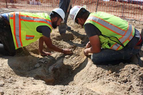
Crews working to build the City of Thornton’s new fire and police substation in the north part of town have unearthed the remains of a dinosaur.
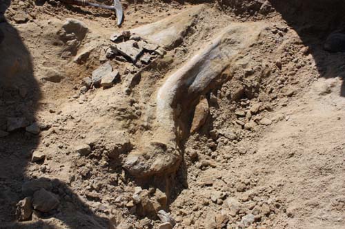
The finding of the 66-million-year-old triceratops includes the skull and other bones. Dr. Joe Sertich, Curator of Dinosaurs, Denver Museum of Nature and Science, spoke to the rarity of the find saying, “This is probably one of only three skulls of triceratops found along the front range area.”
The full press release from the City of Thornton:
Rare dinosaur fossil uncovered in Thornton
“This dinosaur has been laying here for at least 66-million years.”
THORNTON, CO… Scientists from the Denver Museum of Nature & Science (DMNS) are working at the site of a fossil discovery in Thornton. On Friday, August 25, construction crews working on Thornton’s new Public Safety Facility at 132nd Avenue and Quebec Street uncovered the fossil, and scientists at DMNS were on-site on Monday, August 28, to confirm it is a fossil. “My heart was racing,” says DMNS Curator of Dinosaurs Joe Sertich. “I realized it was a pretty important dinosaur find.”
After initially clearing away some of the dirt at the site, Sertich says it appears to be a triceratops skeleton and skull. “This is probably one of only three skulls of triceratops found along the Front Range area,” says Sertich. According to Sertich, most fossil finds along the Front Range are from the Ice Age, just 10 to 12-thousand years old, but this fossil is much older, and much rarer. “This dinosaur has been laying here for at least 66-million years,” says Sertich. “I’m over the moon right now about this dinosaur fossil.”
The city of Thornton is providing security at the fossil site to ensure the items make it safely to its new home. The fossil site is not visible from the street, and because this is an active construction site, only museum personnel, city of Thornton crews and construction personnel are permitted on the site. Thornton is making the following media resources available for covering the story: video of site (broadcast quality), video interviews, still photos. These resources can be found at www.gocot.net/dinosaur. Again, no access to the construction site will be permitted for safety reasons. Interviews may be facilitated upon request. For more information go to cityofthornton.net.
Photos and video courtesy the City of Thornton.
Tropical Storm Harvey Adds to Texas Floods as Trump Set to Visit Region
|
Human chains and jet skis: Texans come to the rescue
|
August 27 to September 2: This week in Denver weather history

This time of year we usually see calm conditions as we begin the transition to fall. However, that is not always the case as is seen in our look back at this week in history. Everything from thunderstorms with hail to tornadoes can and have been experienced.
From the National Weather Service:
19-30
In 1875…grasshoppers appeared in great numbers at 10:00 am on the 19th. Thousands landed on the ground. The streets were literally covered with them. Swarms of grasshoppers were seen on each day. All gardens in the city were devastated…and in the countryside the grasshoppers were very destructive to ripened grain. On the 30th the grasshoppers were so numerous as to almost darken the sun.
26-27
In 1980…two heavy thunderstorms hit Arvada and Westminster… Dumping up to 1.50 inches of rain in less than an hour. At least two streets were washed out and a number of homes and cars were damaged when a creek flooded. Three homes in Arvada sustained minor lightning damage.
27
In 1910…a thunderstorm produced south winds sustained to 40 mph.
In 1961…strong thunderstorm winds and heavy rain occurred at 79th and Federal Blvd. in Westminster. The strong winds blew the roofs off lumber sheds onto parked cars.
In 1967…a young woman was killed by lightning while horseback riding in the suburbs just west of Denver. Her horse died several hours after the incident. A young man and another young woman were also knocked from their horses by the impact of the lightning and required hospitalization.
In 1991…heavy thunderstorm rainfall totaled 0.91 inch at Stapleton International Airport…where 1/4 inch diameter hail was measured.
In 1996…localized street flooding occurred in the Fort Lupton area when 2 to 3 inches of rain fell in 45 minutes. The roof of a community college began leaking…which caused damage to ceiling tiles. The roof was under repair from hail damage which had occurred earlier in the summer. A weak tornado (F0) was sighted near Fort Lupton. No damage was reported.
In 1999…a slow moving thunderstorm dumped 5 inches of rain in 2 hours near Dacono. A severe thunderstorm produced 3/4 inch diameter hail in Castle Rock.
In 2002…severe thunderstorms spread large hail over metro Denver. Hail as large as 2 inches in diameter fell in Jefferson County 5 to 11 miles northwest of Golden. Other large hail reports included: 1 1/2 inches near Golden and in Lakewood; 1 1/4 inches in Nederland; 1 inch hail near Elizabeth…Louviers…Rollinsville…and Blackhawk; 7/8 inch hail near Acequia in Douglas County. A thunderstorm produced a trace of rain and a microburst wind gust to 52 mph at Denver International Airport.
In 2003…lightning struck a house and sparked a fire in Arvada. Damage to the roof and ceiling was extensive.
In 2005…lightning struck an unoccupied home in Parker. The resulting fire damaged the roof…attic…and second floor bedroom. Damage was estimated at 15 thousand dollars.
27-28
In 2004…a brief chilly spell resulted in three temperature records. The high temperature of 55 degrees on the 27th was a record low maximum for the date. The low temperature of 48 degrees on the 27th equaled the record minimum for the date. The low temperature of 42 degrees on the 28th was a record minimum for the date.
28
In 1887…a dry thunderstorm produced north winds to 48 mph but only a trace of rainfall.
In 1968…one man was seriously injured by lightning while riding on a roller coaster at a Denver amusement park. An airline employee was injured when lightning struck a jetliner he was servicing at Stapleton International Airport. A lightning-caused fire did extensive damage to one house and minor damage to several others in the city of Denver.
In 1970…a microburst wind gust to 53 mph was recorded at Stapleton International Airport.
In 2002…a severe thunderstorm produced 3/4 inch diameter hail near Parker.
In 2005…lightning sparked a small fire near Jamestown. The blaze was quickly contained and consumed less than an acre.
29
In 1876…after the passage of a gentle rain shower to the east during the late evening hours…the moon shone brightly and a remarkably bright lunar rainbow appeared.
In 1910…an apparent cold front produced sustained northeast winds to 40 mph.
In 1946…the high temperature warmed to only 55 degrees…the record low maximum for the month.
In 1989…a spectacular lightning display knocked out power to 300 blocks in southeast Denver. One bolt started a fire in a lumber yard in the northeast part of the city…and the attic of a home in the same area was set ablaze by a lightning bolt.
In 1996…3/4 inch diameter hail was measured in Parker.
In 2000…lightning struck two homes in Thornton. The extent of damage was unknown.
In 2002…two small tornadoes caused damage in southeast metro Denver. The first tornado…associated with a multi-vortex storm…touched down briefly near E-470 and South Jordan Road. Some fences were damaged…and a few trees were blown down. A few of the homes also sustained minor roof damage. Damage from this storm totaled 100 thousand dollars. The second tornado associated with the storm touched down in a subdivision that was under construction at Gartrell and Arapahoe roads. Four large condominiums under construction were destroyed. The most heavily damaged portions of the structures were still in the framing stages. Adjacent sections where enclosed walls were in place were not destroyed. A man suffered 4 broken ribs and several cuts and bruises when the trailer he sought shelter in was flipped three times and torn apart by the twister. Damage from this storm totaled 6 million dollars. A severe thunderstorm produced 1 inch diameter hail near Evergreen.
In 2006…severe thunderstorms produced large hail in the foothills west of Denver. Hail to 1 inch in diameter fell near Blackhawk. Hail as large as 7/8 inch was measured near Idaho Springs…along with 3/4 inch hail near Nederland and conifer.
30
In 1981…60 mph winds were reported in Boulder.
In 2004…a severe thunderstorm produced hail as large as 1 inch in diameter in south Aurora near Cherry Creek.
31
In 1951…hail as large as 1 3/4 inches in diameter caused an estimated 300 thousand dollars damage in metro Denver. Hail as large as 1 1/2 inches in diameter was measured at Stapleton Airport.
In 1978…strong thunderstorm winds tore the roof off an apartment building in Aurora…downed trees…and damaged windows in Denver. A microburst wind gust to 58 mph was recorded at Stapleton International Airport.
In 1985…a thunderstorm wind gust to 60 mph was clocked at Buckley Field in Aurora.
In 1997…hail to 1 1/4 inches in diameter was measured in Aurora.
In 2006…a female postal worker was struck and injured by lightning while delivering mail in Westminster.
In 2008…lightning struck a home in Brighton…damaging the roof and a bedroom. The damaged totaled 20 thousand dollars.
Continue reading August 27 to September 2: This week in Denver weather history
15 Senior Citizens Saved from Floodwaters
|
Top climate scientist rebuts Al Gore film as ‘bad science’ while ticket sales plummet
|
More Than 24 Million Affected by South Asia Flood Disasters
|
Total solar eclipse mesmerizes America
|
Total Solar Eclipse in 1979 Ended With Moving Message
|