Following on an August that saw seasonal temperatures but little precipitation, some are certainly hoping for a bit of the wet stuff in September. The month can bring plenty of rain and even our first snow of the season but more often than not, it is one of the most pleasant along the Colorado Front Range.
As temperatures start to drop, September usually reminds us that summer is at an end and fall is now here. Sunshine is predominant though as the month actually has the highest percentage of sun out of any month. Sunny days and clear, cool nights are the standard weather pattern for the month.
The month can bring extremes however. We will of course forever remember 2013’s devastating floods brought on by record-setting rain. Longtime residents might remember September 1971 which brought over 17 inches of snowfall.
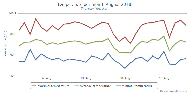
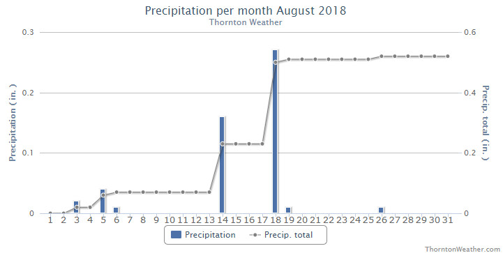
Somewhat of a mixed bag for Thornton’s weather in August. While we enjoyed temperatures near normal without too many extremes, precipitation was lacking considerably from what we expect during the month.
The month started out toward the cool side but with days of above normal temps interspersed. For the first few weeks it appeared we would end up a good bit cooler than normal but then the heat returned for much of the last week driving up average temperatures.
Precipitation was quite disappointing with only a couple decent rainfalls during the month and a few minimal events.
Probably the most notable thing for the month was the relatively persistent haze from smoke from wildfires to our west. While it made for pretty sunrises and sunsets, it obscured our normally beautiful blue skies.
Thornton finished the month with an average temperature of 70.4 degrees. That is more than two degrees cooler than Denver’s long term August average of 72.5 degrees. As is the norm, Denver’s official measurement came in a good bit warmer with an average of 72.4 degrees.
Our highs ranged from a maximum of 94.9 degrees on the 4th of the month down to a low of 47 degrees on the morning of the 20th. Denver matched our maximum on the same date and saw a low of 46 degrees on the 20th which also tied the record low for the date.
The month saw a paltry 0.52 inches fall in Thornton’s rain bucket. Denver actually fared better with 0.93 inches. Both measurements however fell short of the August average of 1.69 inches.
Thornton, Colorado’s August 2018 temperature summary. (ThorntonWeather.com)Thornton, Colorado’s August 2018 precipitation summary. (ThorntonWeather.com)
CLIMATE REPORT
NATIONAL WEATHER SERVICE DENVER/BOULDER CO
318 PM MDT SAT SEP 1 2018

...................................

...THE DENVER CO CLIMATE SUMMARY FOR THE MONTH OF AUGUST 2018...

CLIMATE NORMAL PERIOD 1981 TO 2010
CLIMATE RECORD PERIOD 1872 TO 2018

WEATHER         OBSERVED          NORMAL  DEPART  LAST YEAR`S
                 VALUE   DATE(S)  VALUE   FROM    VALUE  DATE(S)
                                          NORMAL
................................................................
TEMPERATURE (F)
RECORD
 HIGH             105   08/08/1878
 LOW               40   08/26/1910
                        08/25/1910
                        08/24/1910
                        08/22/1904
HIGHEST            95   08/04       105     -10       95  08/19
LOWEST             46   08/20        40       6       51  08/04
AVG. MAXIMUM     86.8              87.2    -0.4     85.7
AVG. MINIMUM     58.0              57.9     0.1     57.3
MEAN             72.4              72.5    -0.1     71.5
DAYS MAX >= 90     11              11.5    -0.5       10
DAYS MAX <= 32      0               0.0     0.0        0
DAYS MIN <= 32      0               0.0     0.0        0
DAYS MIN <= 0       0               0.0     0.0        0

PRECIPITATION (INCHES)
RECORD
 MAXIMUM         5.85   1979
 MINIMUM         0.02   1924
TOTALS           0.93              1.69   -0.76     1.86
DAILY AVG.       0.03              0.05   -0.02     0.06
DAYS >= .01         7               8.6    -1.6        6
DAYS >= .10         2               4.3    -2.3        4
DAYS >= .50         0               1.2    -1.2        2
DAYS >= 1.00        0               0.3    -0.3        0

GREATEST
 24 HR. TOTAL    0.38   08/14 TO 08/14

SNOWFALL (INCHES)
 TOTAL            0.0
RECORD
 TOTAL            0.0               0.0

DEGREE_DAYS
HEATING TOTAL       9                10      -1        8
 SINCE 7/1          9                16      -7        8
COOLING TOTAL     247               244       3      216
 SINCE 1/1        862               688     174      749

FREEZE DATES
RECORD
 EARLIEST     09/08/1962
 LATEST       06/08/2007
EARLIEST                        10/07
LATEST                          05/05
.................................................................

WIND (MPH)
AVERAGE WIND SPEED              10.3
RESULTANT WIND SPEED/DIRECTION   3/176
HIGHEST WIND SPEED/DIRECTION    41/280    DATE  08/27
HIGHEST GUST SPEED/DIRECTION    60/270    DATE  08/27

SKY COVER
POSSIBLE SUNSHINE (PERCENT)   MM
AVERAGE SKY COVER           0.50
NUMBER OF DAYS FAIR           12
NUMBER OF DAYS PC             17
NUMBER OF DAYS CLOUDY          2

AVERAGE RH (PERCENT)     48

WEATHER CONDITIONS. NUMBER OF DAYS WITH
THUNDERSTORMS             9   MIXED PRECIP           0
HEAVY RAIN                1   MODERATE RAIN          3
LIGHT RAIN               12   FREEZING RAIN          0
LT FREEZING RAIN          0   HAIL                   0
HEAVY SNOW                0   SNOW                   0
LIGHT SNOW                0   FOG W/VIS <=1/4 MILE   2
FOG                       4   HAZE                   8

-  INDICATES NEGATIVE NUMBERS.
R  INDICATES RECORD WAS SET OR TIED.
MM INDICATES DATA IS MISSING.
T  INDICATES TRACE AMOUNT.
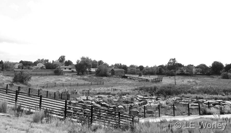
Black and white of a scene in Thornton. (LE Worley)
As the calendar turns to August, the summertime heat begins to fade and that makes it easier to get out and enjoy all of the outdoor activities Colorado has to offer. From a walk in a park to afternoon thunderstorms to an abundance of wildlife, photo opportunities abound as is seen in our slideshow.
Our monsoon season typically arrives about now and that means better chances for moisture. However with limited instability, the intensity of storms are more sedate. That doesn’t mean however that the weather is any less photographic.
Slideshow updated August 31, 2018
By the end of the month some of our seasonal feathered friends will be looking to leave the state giving our last chance to see them till spring. Larger mammals are gearing up for the rut (mating season) and that can make for some intense scenes.
Showcasing images captured by ThorntonWeather.com readers as well as some of our own, our monthly slideshow covers the entire gamut of weather and nature related imagery. Sunsets, sunrises, wildlife and of course every type of weather condition are vividly depicted.
To learn more about how to send your photo to us for inclusion in the slideshow, see below the slideshow.
[flickr_set id=”72157699591892514″]
What is missing in the slideshow above? Your photo!
Our monthly photo slideshow is going to feature images that we have taken but more importantly images that you have captured. The photos can be of anything even remotely weather-related.
Landscapes, current conditions, wildlife, pets, kids. Whimsical, newsy, artsy. Taken at the zoo, some other area attraction, a local park, a national park or your backyard. You name it, we want to see and share it!
Images can be taken in Thornton, Denver or anywhere across the extraordinary Centennial State. We’ll even take some from out of state if we can tie it to Colorado somehow.
We’ll keep the criteria very open to interpretation with just about any image eligible to be shown in our slideshows.
What do you win for having your image in our slideshow? We are just a ‘mom and pop’ outfit and make no money from our site so we really don’t have the means to provide prizes. However you will have our undying gratitude and the satisfaction that your images are shared on the most popular website in Thornton.
To share you images with us and get them included in the slideshow just email them to us or share them with ThorntonWeather.com on any of the various social media outlets. Links are provided below.
August 26 to September 1: This week in Denver weather history
Significant events on Denver’s weather history calendar get a bit less numerous as we enter what is historically a relatively quiet period of the year. That isn’t to say however that major weather events can’t occur. Our look back at this week in Denver weather history includes a massive hail storm in 1944, many events in which lightning injured people and the warmest temperature ever recorded in September.
From the National Weather Service:
19-30
In 1875…grasshoppers appeared in great numbers at 10:00 am on the 19th. Thousands landed on the ground. The streets were literally covered with them. Swarms of grasshoppers were seen on each day. All gardens in the city were devastated…and in the countryside the grasshoppers were very destructive to ripened grain. On the 30th the grasshoppers were so numerous as to almost darken the sun.
24-26
In 1910…the lowest temperature ever recorded in August…40 degrees…occurred on each of these days and on August 22… 1904. The unusually cold weather for so early in the season brought sub-freezing minimum temperatures to much of the Colorado northeastern plains.
26
In 1944…one of the most destructive hailstorms in the city in a decade caused damage estimated at nearly one million dollars. The storm occurred within a period of 10 to 30 minutes…between 2:00 pm and 3:00 pm. The hail varied in size from very small to as large as 1 1/2 inches in diameter. Hail covered the ground to a depth of 5 to 6 inches in some sections of the city. Several people were cut by broken glass. The hail and heavy rain flooded underpasses to a depth of 6 feet…and the occupants of stalled autos had to be rescued. Sewers were unable to handle the sudden amount of water and water backed up and flooded a number of basements. A few first floors of buildings were flooded. The water department had a busy time replacing manhole covers that had been displaced by the water pressure. Trees were stripped…one was severely broken…and telephone lines were downed. Roofs…windows… automobiles…awnings…and gardens were severely damaged. Flowers and gardens in some sections of the city were a total loss. Greenhouses were extensively broken with an estimated 20 carloads of glass shattered. Vegetable and truck crops in and around the city were severely shredded. The next day the American Red Cross was designated by the war agency to grant any and all priorities needed to obtain materials and supplies to replace and repair the damage. In downtown Denver…the thunderstorm produced 0.95 inch of rain and heavy hail along with sustained northwest winds to 25 mph.
In 1961…strong winds blew in the walls of a warehouse under construction in Denver. Two workmen suffered a fractured foot and body bruises.
In 2014…two men in central Denver were struck by lightning as they sat under a tree to avoid a heavy downpour. One of the men was unconscious and had no pulse when emergency responders arrived. He was immediately taken to Denver Health was listed in critical condition. The other victim suffered less severe injuries. He was treated at the scene and hospitalized…then released a few hours later.
26-27
In 1980…two heavy thunderstorms hit Arvada and Westminster… Dumping up to 1.50 inches of rain in less than an hour. At least two streets were washed out and a number of homes and cars were damaged when a creek flooded. Three homes in Arvada sustained minor lightning damage.
27
In 1910…a thunderstorm produced south winds sustained to 40 mph.
In 1961…strong thunderstorm winds and heavy rain occurred at 79th and federal blvd. In Westminster. The strong winds blew the roofs off lumber sheds onto parked cars.
In 1967…a young woman was killed by lightning while horseback riding in the suburbs just west of Denver. Her horse died several hours after the incident. A young man and another young woman were also knocked from their horses by the impact of the lightning and required hospitalization.
In 1991…heavy thunderstorm rainfall totaled 0.91 inch at Stapleton International Airport…where 1/4 inch diameter hail was measured.
In 1996…localized street flooding occurred in the Fort Lupton area when 2 to 3 inches of rain fell in 45 minutes. The roof of a community college began leaking…which caused damage to ceiling tiles. The roof was under repair from hail damage which had occurred earlier in the summer. A weak tornado (f0) was sighted near Fort Lupton. No damage was reported.
In 1999…a slow moving thunderstorm dumped 5 inches of rain in 2 hours near Dacono. A severe thunderstorm produced 3/4 inch diameter hail in Castle Rock.
In 2002…severe thunderstorms spread large hail over metro Denver. Hail as large as 2 inches in diameter fell in Jefferson County 5 to 11 miles northwest of Golden. Other large hail reports included: 1 1/2 inches near Golden and in Lakewood; 1 1/4 inches in Nederland; 1 inch hail near Elizabeth…Louviers…Rollinsville…and Blackhawk; 7/8 inch hail near Acequia in Douglas County. A thunderstorm produced a trace of rain and a microburst wind gust to 52 mph at Denver International Airport.
In 2003…lightning struck a house and sparked a fire in Arvada. Damage to the roof and ceiling was extensive.
In 2005…lightning struck an unoccupied home in Parker. The resulting fire damaged the roof…attic…and second floor bedroom. Damage was estimated at 15 thousand dollars.
August 19 to August 25: This week in Denver weather history
Funnel clouds, tornadoes, deadly flooding and more highlight our look back at this week in Denver weather history.
From the National Weather Service:
16-19
In 1979…heavy thunderstorm rains on each of 4 consecutive days dumped a total of 2.62 inches of rain on Stapleton International Airport. The heaviest rain…1.05 inches… On the 19th was accompanied by 1/4 inch diameter hail.
18-19
In 1875…nearly 0.75 inch of rainfall in the city overnight… Possibly assisted by heavier rainfall upstream…produced a decided and rapid rise in Cherry Creek…which washed out some bridges. Other small creeks and streams were filled to overflowing.
19
In 1983…heavy rain fell across the northern metro Denver suburbs with 1.50 to 1.80 inches of rain in Broomfield… Arvada…and Thornton.
In 1989…lightning killed a 31-year-old man and injured his 10 year old nephew when it hit a tree they were walking under in the foothills about 5 miles west of Boulder. The boy received mouth to mouth resuscitation on the scene and recovered after being hospitalized overnight. Three other people were knocked to the ground by the bolt…but were uninjured.
In 1990…3/4 inch diameter hail was reported in Wheat Ridge. A thunderstorm over west Denver dumped an inch of rain in 20 minutes…causing minor street flooding. One inch diameter hail was reported over east Denver. Ping pong to golf ball size hail was reported 14 miles northeast of Denver at the intersection of 122nd Ave. and Brighton Blvd. The hail stones knocked out windows and did an unspecified amount of damage to the roof of a house. Close by…heavy thunderstorm rains caused gullies…irrigation ditches…and small streams to overflow their banks near the intersection of 120th Avenue and Riverdale Road. Flood waters 1 to 2 feet deep covered the river bottom land along the South Platte River. However…no structures were threatened by the flood waters.
In 1999…heavy rain…up to 5 inches in two hours…caused east tollgate creek to jump its banks. The bike path adjacent to the creek was underwater at several locations. Several underpasses were also flooded…halting traffic. In addition…an unfinished playground at a local elementary school was completely flooded. Lightning struck a vehicle at east Evans Avenue and Tower Road. The woman inside the vehicle was not injured.
19-30
In 1875…grasshoppers appeared in great numbers at 10:00 am on the 19th. Thousands landed on the ground. The streets were literally covered with them. Swarms of grasshoppers were seen on each day. All gardens in the city were devastated…and in the countryside the grasshoppers were very destructive to ripened grain. On the 30th the grasshoppers were so numerous as to almost darken the sun.
20
In 1980…winds to 55 to 60 mph were recorded in south Boulder.
In 1982…strong thunderstorm winds blasted the Jefferson County Airport near Broomfield…causing an estimated 3 million dollars in damage. At least 5 hangars and 15 airplanes were damaged…many seriously; one hangar was completely destroyed. Torrential rains accompanied the winds. Heavy rains also dumped on Boulder where 1.65 inches fell in just 15 minutes…causing street flooding. Wind gusts to 72 mph were recorded in Boulder. Over half an inch of rain fell in just 5 minutes in Littleton where two homes were struck by lightning. Lightning also struck a house in Arvada where over an inch of rain sent Ralston Creek over its banks. Strong winds accompanied the storms.
In 1984…slow moving thunderstorms dumped 1.25 inches of rain in Evergreen…causing street flooding. A half inch of rain fell in just 18 minutes in southeast Denver. Littleton and Boulder were also drenched with about an inch of rain. Rainfall totaled 0.92 inch at Stapleton International Airport.
In 2001…severe thunderstorms produced damaging winds and large hail across metro Denver. Hail as large 1 inch in diameter fell in Aurora near Cherry Creek. Strong thunderstorm winds gusting as high as 58 mph blew the roof from a building between Thornton and Denver and toppled several trees in Denver. One tree landed on a mail truck. Other thunderstorm winds were clocked to 60 mph near Parker… 62 mph in Broomfield…and 61 mph at Denver International Airport.
In 2006…a tornado (f0) touched down near Bennett…but caused no reported damage.
In 2013…severe thunderstorms pounded the southern Denver suburbs and other parts of the Front Range. In Jefferson County…water rescues were reported for some people in stranded cars. In the Ken Caryl area…large hail from one inch to 1 3/4 inches in diameter was reported. On West Chatfield Avenue in Jefferson County…hail runoff gathered six inches deep in spots and “hail plows” were sent out to clear some streets. Hail up to one inch in diameter was also reported near Castle Rock.
21
In 1876…heavy thunderstorm rain and hail struck the city. Hail stones as large as partridge eggs accumulated to a depth of 1 1/2 feet over eastern portions of the city. The heavy rainfall flooded streets and gutters. However… No significant damage was reported. Rainfall totaled 0.85 inch in central Denver.
In 1903…a thunderstorm produced west winds sustained to 42 mph with gusts to 48 mph.
In 1957…heavy thunderstorm rainfall and hail over the bear creek basin flooded portions of State Highway 8 in and near Morrison. There was also minor property damage in Morrison.
In 1995…a 68-year-old woman was struck by lightning while standing near a tree in Brighton.
In 2006…a severe thunderstorm produced 7/8 inch diameter hail in Franktown.
If you were thinking you were feeling fall in the air the last day or two you had good reason. Temperatures this morning almost felt chilly and Denver tied the record low temperature for the date.
At 6:25am this morning, the mercury at Denver International Airport where the Mile High City’s official records are taken dipped to 46 degrees. This tied the record low temperature for August 20 last set in 1939.
Here in Thornton we were just a touch warmer with a low of 47 degrees. That was our second chilliest temperature since May 21.
Stay up to date with Thornton’s weather: ‘Like’ us on Facebook, follow us on Twitter and add us to your Google+ circles
The silence from the Thornton PD has been deafening. As other Denver metro area police departments posted their lip sync challenge entry, we heard nothing from the local men and women in blue. That changed today.
Set to the song “Danger Zone” by Kenny Loggins and made famous in the movie Top Gun, the Thornton Police Department brings it all from cars to motorcycles to yes, even planes.
All in all, we have to say the video is worth the wait and probably the best we have seen from any local agency. Of course we are residents of Thornton and Navy veterans so we might be biased. 😉
August 12 to August 18: This week in Denver weather history
Denver’s weather calms considerably in August as compared to many other months but the history books show plenty of notable events in our past. Lightning, flooding rain and even a tornado highlight this week in Denver weather history.
8-13
In 1875…clouds of grasshoppers were seen flying through the air on the prevailing winds during each day.
12
In 1876…the temperature climbed to a high of 100 degrees in downtown Denver.
In 1941…excessive thunderstorm rainfall flooded streets and delayed traffic for a few hours in some sections of the city. The basements of a considerable number of homes and commercial buildings were flooded. The total value of the damage was unknown. Only 0.94 inch of thunderstorm rainfall was recorded downtown.
In 1969…a man and a 9-year old boy were injured…when lightning struck a tree near where they were standing. Both were revived after treatment…but the boy later died of respiratory failure due to electrical shock.
In 1984…heavy thunderstorm rains drenched southern metro Denver. Rural roads in Douglas County received minor washouts. Hail…as large as 3/4 inch in diameter…was reported in southeast Aurora with one inch diameter hail reported near Parker. Rainfall totaled 1.00 inch at Stapleton International Airport.
12-13 in 1975…heavy rains caused flash flooding along the foothills from Denver north. Thunderstorm rainfall totaled 1.56 inches at Stapleton International Airport.
In 2004…a brief cool spell resulted in two daily temperature records. The low temperature of 49 degrees was a record minimum for the 12th…as was the low temperature of 48 degrees on the 13th.
13
In 1959…thunderstorm winds gusted to 53 mph at Stapleton Airport.
In 1983…thunderstorms dumped torrential rain in Northglenn… Thornton…and Broomfield. Northglenn was drenched with 1.72 inches in 30 minutes. Street flooding was widespread. Hail…as large as 3/4 inch in diameter…was reported 7 miles northeast of Boulder along with heavy rain which caused some street flooding.
In 2000…lightning sparked 3 small grass fires near Golden. The fires were quickly contained. Hail as large as 3/4 inch in diameter fell in Castle Rock.
14
In 1960…a bolt of lightning struck a man in Henderson… Causing serious burns.
In 1962…the temperature climbed to a high of 100 degrees at Stapleton Airport.
In 1968…a young man on a golf course in Denver was injured when lightning struck a tree under which he was standing. Lightning caused minor damage to a house in Denver. Heavy thunderstorm rain caused local street flooding. One inch diameter hail fell at Jefferson County Airport near Broomfield.
In 1973…winds as high as 85 mph damaged 20 aircraft at the Arapahoe County airport…now centennial airport.
In 1977…three tornadoes were sighted in Bennett. A man suffered a broken leg when hit by a flying board. He was outside his camper home…which was destroyed. All windows were broken in a near-by farmhouse where some shingles were ripped off and a 2 car garage was knocked down. Several vehicles were damaged and a cat…some rabbits…and chickens were killed. A broken oar from a boat was driven into the side of a house. A mobile home was overturned. One old barn was destroyed. Half a dozen homes and several agricultural buildings were damaged just west of State Highway 79.
In 1978…high winds produced much blowing dust…causing many traffic accidents in the Denver-Boulder area. Winds gusts of 70 to 101 mph were recorded. Northwest winds gusted to 44 mph at Stapleton International Airport.
In 1980…lightning hit two power poles in Littleton…causing 400 dollars in damage. Rainfall of 1.23 inches in a short time caused minor flooding…which included damage to a ground floor apartment and partially submerging a few vehicles in water. Thunderstorm rainfall totaled 0.98 inch at Stapleton International Airport.
In 1983…2.10 inches of rain drenched Golden in an hour with similar amounts in Lakewood and Boulder. Over ten thousand dollars worth of plants were washed away at a nursery in Lakewood.
In 1997…twelve motorists were injured in a multi-car accident when strong microburst winds estimated to 50 mph blew blinding dust across I-70 near Bennett.
In 1998…lightning struck a hydro-electric plant in Nederland… Causing a power outage. Residents in the foothills west of Boulder…including Nederland…Ward…Eldora…Jamestown… And Gold Hill…were without power for about an hour.
In 2006…heavy thunderstorm rainfall near Deckers washed away some the banks along State Highway 67 between Deckers and Westcreek. Several driveways on both sides of the highway were also damaged.
15
In 1899…a thunderstorm produced southwest sustained winds to 43 mph with gusts to 46 mph.
In 1972…a pilot reported a funnel cloud briefly touching the ground in open fields…17 miles east-northeast of Stapleton International Airport.
In 1980…thunderstorm winds gusted to 55 mph in Boulder.
In 1982…brief heavy rain and winds estimated as high as 70 mph occurred in the conifer-Evergreen area. No damage was reported.
In 1990…lightning triggered a small attic fire in a house near Sedalia…20 miles south of Denver. A furious lightning storm caused widespread power outages across southern sections of metro Denver. One lightning bolt knocked out an electrical substation…causing a 90-minute blackout in southeast Denver affecting nearly 10 thousand homes and businesses.
In 2007…severe thunderstorms produced large hail…up to 2 inches in diameter…near larkspur. Extensive damage to vehicles in the area was reported.
In Parker…lightning struck a residence. The ensuing fire damaged the attic and top floor; causing $100000 in property damage.
In 2008…at least three homes were hit by lightning during the early morning hours in Arapahoe County. Lightning also struck two homes in Castle Rock…damaging the roofs.
In 2013…a dry microburst uprooted 30 to 40 large trees across a 12-block area of the Park Hill neighborhood in east central Denver. Several trees were snapped near the base along with numerous branches…8 to 10 inches in diameter. Power poles and lines were also downed with resulted in outages which affected seven hundred residents. One of the downed trees crushed a car`s hood… narrowly missing the driver. At Denver International Airport…a peak wind gust of 22 mph was observed from the southwest.
As summer vacations wind down and families prepare to send their kids back to school in August, Colorado weather also starts to settle down. The chances for severe weather decrease markedly during August and by the end of the month daytime temperatures are dropping quite a bit as well.
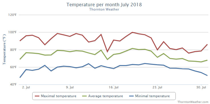
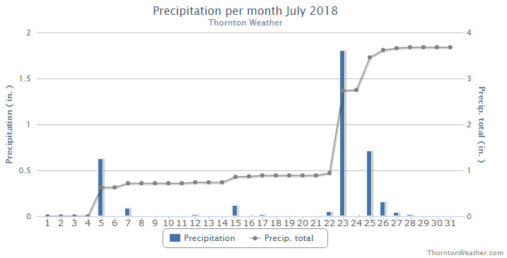
The month of July was somewhat a tale of two months in one. The first half was most notable for their unseasonably warm temperatures and relatively dry conditions. The second half saw a few days of heat but for the most part was considerably cooler and wetter.
Thornton saw an average temperature for the month of 73.5 degrees. Out at Denver International Airport where the Mile High City’s official readings are taken, the month saw an average of 75.3 degrees. Long term, the month of July sees an average of 74.2 degrees in Denver so while Thornton was cooler than that, Denver was warmer.
Thornton had its highest temperature reading of 99.9 degrees on the 19th and its coldest of 47.7 degrees on the 1st. Denver saw its warmest reading of 99 degrees on the 3rd and its coldest of 47 degrees on the 1st.
In terms of precipitation, Denver’s long term July average is 2.16 inches. Thornton easily bested that number with 3.66 inches in our rain bucket. The Mile High City fell well short with only 1.03 inches.
Thornton, Colorado’s July 2018 temperature summary. (ThorntonWeather.com)Thornton, Colorado’s July 2018 precipitation summary. (ThorntonWeather.com)
CLIMATE REPORT
NATIONAL WEATHER SERVICE DENVER/BOULDER CO
305 PM MDT WED AUG 1 2018

...................................

...THE DENVER CO CLIMATE SUMMARY FOR THE MONTH OF JULY 2018...

CLIMATE NORMAL PERIOD 1981 TO 2010
CLIMATE RECORD PERIOD 1872 TO 2018

WEATHER         OBSERVED          NORMAL  DEPART  LAST YEAR`S
                 VALUE   DATE(S)  VALUE   FROM    VALUE  DATE(S)
                                          NORMAL
................................................................
TEMPERATURE (F)
RECORD
 HIGH             105   07/20/2005
 LOW               42   07/04/1903
                        07/31/1873
HIGHEST            99   07/03        99       0      100  07/19
                                                          07/06
LOWEST             47   07/01        51      -4       51  07/01
AVG. MAXIMUM     90.2              89.4     0.8     91.5
AVG. MINIMUM     60.3              58.9     1.4     61.3
MEAN             75.3              74.2     1.1     76.4
DAYS MAX >= 90     19              16.0     3.0       20
DAYS MAX <= 32      0               0.0     0.0        0
DAYS MIN <= 32      0               0.0     0.0        0
DAYS MIN <= 0       0               0.0     0.0        0

PRECIPITATION (INCHES)
RECORD
 MAXIMUM         6.41   1965
 MINIMUM         0.01   1901
TOTALS           1.03              2.16   -1.13     0.47
DAILY AVG.       0.03              0.07   -0.04     0.02
DAYS >= .01         8               8.3    -0.3        6
DAYS >= .10         3               4.3    -1.3        3
DAYS >= .50         0               1.4    -1.4        0
DAYS >= 1.00        0               0.7    -0.7        0
GREATEST
 24 HR. TOTAL    0.43   07/23 TO 07/23

SNOWFALL (INCHES)
 TOTAL            0.0               0.0
RECORDS
 TOTAL            0.0

DEGREE_DAYS
HEATING TOTAL       0                 6      -6        0
 SINCE 7/1          0                 6      -6        0
COOLING TOTAL     326               289      37      360
 SINCE 1/1        615               444     171      533

FREEZE DATES
RECORD
 EARLIEST     09/08/1962
 LATEST       06/08/2007
EARLIEST                        10/07
LATEST                          05/05
.................................................................

WIND (MPH)
AVERAGE WIND SPEED              10.1
RESULTANT WIND SPEED/DIRECTION   2/138
HIGHEST WIND SPEED/DIRECTION    47/140    DATE  07/02
HIGHEST GUST SPEED/DIRECTION    64/150    DATE  07/02

SKY COVER
POSSIBLE SUNSHINE (PERCENT)   MM
AVERAGE SKY COVER           0.50
NUMBER OF DAYS FAIR           10
NUMBER OF DAYS PC             20
NUMBER OF DAYS CLOUDY          1

AVERAGE RH (PERCENT)     50

WEATHER CONDITIONS. NUMBER OF DAYS WITH
THUNDERSTORMS            13   MIXED PRECIP           0
HEAVY RAIN                3   RAIN                   5
LIGHT RAIN               11   FREEZING RAIN          0
LT FREEZING RAIN          0   HAIL                   0
HEAVY SNOW                0   SNOW                   0
LIGHT SNOW                0   FOG W/VIS <=1/4 MILE   3
FOG                       8   HAZE                   5

-  INDICATES NEGATIVE NUMBERS.
R  INDICATES RECORD WAS SET OR TIED.
MM INDICATES DATA IS MISSING.
T  INDICATES TRACE AMOUNT.
Weather, natural disasters & climate news and information.
 Following on an August that saw seasonal temperatures but little precipitation, some are certainly hoping for a bit of the wet stuff in September. The month can bring plenty of rain and even our first snow of the season but more often than not, it is one of the most pleasant along the Colorado Front Range.