The unseasonably warm weather this week reached record setting levels today. At 1:55pm the temperature at Denver International Airport reached 87° tying the record high temperature for the date previously set on May 14, 1996.
Here in Thornton we were a couple of degrees warmer as the mercury climbed to 89°. This is the warmest temperature we have recorded since September 10 of last year (91°).
Don’t miss a thing when it comes to our ever changing weather! Be sure to ‘like’ us on Facebook, follow us on Twitter and add us to your Google+ circles.
May 12 to May 18: This Week in Denver Weather History
The snow is gone – almost – but as our look back at this week in Denver weather history shows, it could return. That however is unlikely and more typical spring severe weather is far more common.
From the National Weather Service:
10-12
In 2011…a spring snowstorm brought heavy snow to the Front Range foothills and Palmer Divide. Storm totals included: 18 inches…4 miles south-southeast of Pinecliffe; 16 inches in Coal Creek Canyon; 15 inches…4 miles west-southwest of Eldorado Springs; 13 inches at Gold Hill…12 inches…4 miles west-southwest of Conifer and 4 miles northwest of Elizabeth; 11.5 inches…6 miles southwest of Evergreen and 4 miles east-northeast of Nederland; 11 inches…3 miles east of Jamestown and 10.5 inches…3 miles east of Franktown and 3 miles south of Golden and 10 inches…10 miles north of Elizabeth. At Denver International Airport… 1 inch of snowfall was observed.
12
In 1875…two forest fires on the eastern slope of the foothills were visible from the city.
In 1904…north winds were sustained to 40 mph with gusts to 48 mph.
In 1950…brilliant and complete primary and secondary rainbows arching across the sky were observed from Stapleton Airport.
In 1951…a wind gust to 51 mph was recorded at Stapleton Airport.
In 1984…winds gusted to 69 mph in Boulder. Northwest winds gusted to 47 mph at Stapleton International Airport.
In 1987…a small weak tornado touched down for about 2 minutes in southeast Denver. The twister hit a car dealership…blowing about a dozen windows out of cars and shattering four skylights on the building. Some tin roofing was blown off a patio a block and a half away. The tornado also downed a power pole. Damage at the dealership was estimated at 10 thousand dollars. A man was slightly injured by lightning in northwest Aurora.
In 1995…several funnel clouds were sighted near Parker. One of the funnels produced a short-lived debris cloud on the ground in an open field. No damage was reported.
12-13
In 1907…the temperature warmed to a high of 73 degrees on the 12th…before a cold front produced a thunderstorm… Northeast winds sustained to 40 mph…and rain changing to light snow overnight. Snowfall totaled only 2 inches…but the high temperature on the 13th was only 39 degrees.
In 1961…a storm that covered metro Denver with rain and snow started as thunderstorms on the evening of the 12th. Hail to 1 1/2 inches in diameter was reported 10 miles northwest of Stapleton Airport. Rain continued overnight and changed to snow on the 13th. Snowfall totaled 6.4 inches and precipitation (rain and melted snow) 1.96 inches at Stapleton Airport where north winds gusted to 39 mph. The rain and heavy wet snow caused icing damage to utility lines. Heavy snow occurred in the foothills.
In 1982…a major storm dumped 1.50 to 3.50 inches of rain across northeast Colorado and deposited prodigious amounts of snow in the foothills. Coal Creek Canyon southwest of Boulder was buried under 46 inches of snow with 39 inches at Nederland. The heavy wet snow downed many power lines in the foothills. In Thornton…the roof of a school was damaged by water from the heavy rain. At Stapleton International Airport…1.49 inches of rain were measured over the two day period. The heavy rain ended a severe and prolonged drought.
In 2004…a winter storm produced heavy snow in excess of a foot in the foothills above 6 thousand feet while heavy rain fell across the city. The heaviest snow occurred in the high country of Boulder County. Storm total snowfall was 14.5 inches near Jamestown. Rainfall totaled 0.81 inch at Denver International Airport with 0.94 inch recorded at Denver Stapleton. A trace of snow was recorded at both locations. East winds gusted to 24 mph at Denver International Airport on the 12th.
13
In 1905…a thunderstorm produced hail during the late afternoon. Precipitation totaled 0.57 inch.
13-14
In 1912…heavy snowfall totaled 12.4 inches over the city. Most of the snow…9.9 inches…fell on the 13th…which was the greatest 24 hour snowfall in May at the time. This was the last snowfall of the season. The low temperature dipped to 27 degrees on the morning of the 14th.
In 1989…a spring storm brought heavy rain and snow to the foothills. Metro Denver was soaked with 1 to 2 inches of rain. Rainfall totaled 1.26 inches at Stapleton International Airport.
In the foothills…Echo Lake received 20 inches of snow. A 30-ton Boulder slid onto I-70 east of the Eisenhower Tunnel…closing the freeway for 2 hours.
May 5 to May 11: This Week in Denver Weather History
This time of year the focus is usually on spring severe weather with lightning, tornadoes and hail being the highlight. Our look back at this week in Denver weather history shows many of those types of events. Also notable are the few, unusually late in the season snow events, some of which were quite heavy.
From the National Weather Service:
1-5
In 1898…snowfall totaled 15.5 inches in downtown Denver. Most of the snow…6.2 inches…fell on the 3rd. Most of the snow melted as it fell. The greatest snow depth on the ground was only 2.5 inches on the 3rd at 8:00 pm. This was the only snowfall during the month. Northeast winds were sustained to 22 mph on the 1st.
2-5
In 2001…a very slow moving pacific storm system became parked near the four corners region…which allowed heavy snow to develop above 6500 feet in the foothills with a mix of rain and snow over lower elevations of metro Denver. Snowfall totals included: 21 inches atop Crow Hill and at Idaho Springs; 19 inches near Blackhawk; and 18 inches in Coal Creek Canyon…Genesee…and 11 miles southwest of Morrison. Snowfall totaled 6.2 inches at the site of the former Stapleton International Airport. Precipitation (rain and melted snow) totaled 2.09 inches at Denver International Airport where north winds gusted to 30 mph on the 2nd.
3-5
In 1908…rain changed to snow on the evening of the 3rd and continued through the early evening of the 5th. Snowfall totaled 10.0 inches over downtown Denver. This was the last measurable snow of the season. Precipitation totaled 1.51 inches. North winds were sustained to 23 mph on the 3rd…33 mph on the 4th…and 21 mph on the 5th. Three temperature records were set. High temperatures of 30 degrees on the 4th and 38 degrees on the 5th were record low maximum temperatures for the dates. The reading on the 4th was also the all-time record low maximum for the month of May.
In 2007…a slow moving pacific storm system…from the desert southwest…brought a period of unsettled weather to the region. During the 3-day period…locally heavy snow was reported over parts of the Front Range foothills. Storm totals included: 15 inches near Conifer…14.5 inches west of Jamestown…13.5 inches; 6 miles southwest of Evergreen…and 12.5 inches at pine junction. Severe thunderstorms…producing large hail…up to one inch in diameter were observed in the vicinity of Boulder and Hudson. Lightning struck a residence in Jefferson County. The roof was hit…causing the attic to catch fire. At Denver International Airport…lightning struck a United Airlines jet as it was pushing away from the gate. The passengers were taken off the jet and put on another plane.
4-5
In 1986…high winds buffeted the foothills. Wind speeds of 60 to 75 mph were recorded in Boulder. At Stapleton International Airport…west winds gusted to 45 mph on the 4th and to 40 mph on the 5th.
In 2000…a brief warm spell resulted in setting two daily high temperature records. The temperature climbed to highs of 87 degrees on the 4th and 89 degrees on the 5th.
4-8
In 1969…heavy rains caused flooding on Boulder creek in Boulder…which resulted in one death on the 7th. Flooding also occurred on bear creek in Sheridan and on the South Platte River in Denver. Rain over most of the eastern foothills started late on the 4th and continued with only brief interruptions in many areas until the morning of the 8th. Very high rates of rainfall occurred on the 6th and 7th with the greatest intensities in a band along the foothills from about 25 miles southwest of Denver northward to Estes Park. Storm totals by both official and unofficial measurements exceeded 10 inches over much of this area and were over 12 inches in some localities. Heavy snow fell in the higher mountains and in the foothills later in the period. The saturation of the soil resulted in numerous rock and landslides…and the heavy run-off caused severe damage along many streams and flooding on the South Platte River. Many foothill communities were isolated as highways were blocked and communications disrupted. Roads were severely damaged over a wide area…and a large number of bridges washed out. Many roads were closed due to the danger from falling rocks. A building in Georgetown collapsed from the weight of heavy wet snow. In Boulder…a man drowned when caught by the flooding waters of Boulder Creek…and a patrolman was injured. Rainfall totaled 7.60 inches in Boulder with 9.34 inches recorded at the Public Service Company electric plant in Boulder Canyon. In Morrison…rainfall totaled 11.27 inches in 4 days. Heavy rainfall totaled 4.68 inches at Stapleton International Airport over 3 days from the 5th through the 7th. Rainfall of 3.14 inches was recorded in 24 hours on the 6th and 7th. Downstream flooding continued along the South Platte River until the 12th when the flood crest reached the Nebraska line.
5
In 1903…apparent post-frontal northeast winds were sustained to 48 mph with gusts to 60 mph.
In 1950…a northwest wind gust to 52 mph was recorded at Stapleton Airport.
In 1969…a funnel cloud was observed for 2 to 3 minutes just north of Parker. Two other funnel clouds were sighted in the same area. The public sighted a tornado 15 miles east of Stapleton International Airport. No damage was reported.
5-6
In 1907…rain changed to snow on the 5th…continued through the night…and totaled 3.50 inches. Northeast winds were sustained to 15 mph on the 5th.
In 1917…post-frontal rain changed to heavy snow and totaled 12.5 inches over downtown Denver. Most of the snow… 12.0 inches…fell on the 5th and this was the greatest 24-hour snowfall ever measured during the month of May. This was also the only measurable snow of the month that year. Low temperatures of 27 degrees on the 5th and 23 degrees on the 6th were record minimums for the dates. High temperatures on both days were in the lower 40’s. Southeast winds were sustained to 24 mph with an extreme velocity to 26 mph.
In 1964…high winds gusted to 54 mph in Boulder and to 80 mph at Jefferson County Airport near Broomfield. Wind gusts of 50 to 60 mph were common over all of eastern Colorado. Buildings…power lines…trees…and vehicles were damaged by the wind. South-southwest wind gusts to 54 mph caused some blowing dust at Stapleton International Airport where the visibility was briefly reduced to 2 miles.
In 1973…a heavy driving rain storm with embedded thunderstorms…produced 1 to 5 inches of rain and caused local flash flooding along the east slopes of the Front Range. The greatest flash flooding occurred in metro Denver where rainfall totaled 3.56 inches at Stapleton International Airport. Flooding in metro Denver occurred on Clear Creek and the South Platte River…already swollen from heavy snowmelt. Numerous basements were flooded… Roads and streets were washed out…a bridge was demolished… And miscellaneous other damage was reported. North winds gusted to 39 mph at Stapleton International Airport during the storm. The storm produced major downstream flooding along the South Platte River all the way to the Nebraska border during the next two weeks. One person died and total damage was estimated at around 120 million dollars.
In 1978…heavy wet snow of around 24 inches collapsed an office and hotel building in Boulder. Many cars were abandoned in the city. Denver received 14 inches of heavy wet snow with Evergreen and Golden reporting 12 inches. Snowfall totaled 12.4 inches at Stapleton International Airport with a total accumulation of snow on the ground of 8 inches due to melting. Southeast winds gusted to 23 mph on the 5th. Temperatures both days remained in the lower to mid-30’s.
Denver’s recent cold continued as this morning one low temperature record was broken, another tied.
In the wake of our May Day snowstorm, clear skies the following morning allowed temperatures to plummet and reach very winter-like levels. As the mercury bottomed out, Denver broke one low temperature record and tied another.
As measured at Denver International Airport, the temperature this morning dropped to 19 degrees at 6:41am. This easily breaks the previous record low temperature for May 2 of 22 degrees set in 1954.
Most notably, the 19 degree reading also tied the record for the lowest temperature ever recorded during the month of May since record keeping began in Denver in 1872. We have to go all the way back to May 3, 1907 to find a reading that low during May.
Here in Thornton we were quite cold as well although not quite as much as DIA. Our morning low temperature of 20.7 degrees was seen at 6:00am.
The cold and snowy start to May mimics what was seen during the month of April. Last month Denver recorded its fifth coldest and 11th snowiest April on record.
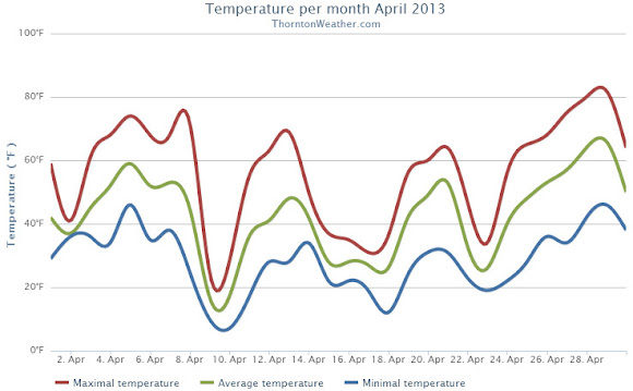
When we look back at April 2013 it will be remembered for two key things: the cold and the snow. By both measurements the month saw extremes with temperatures well below normal and well above normal snowfall, the third month in a row we experienced those conditions.
A series of storm systems moved through during April providing regular doses of cold and snow. Three systems from the 9th of the month through the 25th, each coming at the start of the workweeks, provided the notable conditions. Seventeen of those 18 days saw below normal temperatures.
Denver’s official average temperature for the month came in at 41.7 degrees. This was an impressive 5.7 degrees below the 1981 – 2000 historical average. This put April 2013 into the books as the fifth coldest April since recordkeeping began in Denver. Thornton was only slightly better with an April average temperature of 42.3 degrees.
On four days Denver failed to see high temperatures climb above freezing, Thornton registered three such days.
Five cold temperature records were setting during the month. Record lows were set on April 9th, April 10th and April 22nd. The record low was tied on April 16th. A record low maximum was recorded on the 9th as well.
Temperatures ranged from a high of 80 degrees on the 29th down to a low of 6 degrees on the 10th in Denver. Thornton’s temperatures were similar with a high of 81.7 degrees on the 29th and a low temperature for the month of 6.7 degrees on the 10th.
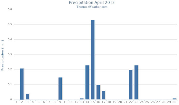
The precipitation was the second half of the April 2013 story with plenty of that falling, primarily in the form of snow.
Denver officially recorded 1.87 inches of liquid precipitation, just a bit above the April average of 1.71 inches. Thornton was just a touch drier with 1.77 inches of precipitation.
Snow was in abundance as Denver saw 20.4 inches of snowfall as measured at Denver International Airport. Thornton was trailing with 19.1 inches. Both marks were well above the Denver April normal of 6.8 inches. Denver’s measurement fell just short of making the list of 10 snowiest Aprils with April 2013 ranking as the 11th snowiest.
Thornton, Colorado April 2013 Temperatures.Thornton, Colorado April 2013 precipitation.
From the National Weather Service:
...THE DENVER CO CLIMATE SUMMARY FOR THE MONTH OF APRIL 2013...

CLIMATE NORMAL PERIOD 1981 TO 2010
CLIMATE RECORD PERIOD 1872 TO 2013

WEATHER         OBSERVED          NORMAL  DEPART  LAST YEAR`S
                 VALUE   DATE(S)  VALUE   FROM    VALUE  DATE(S)
                                          NORMAL
................................................................
TEMPERATURE (F)
RECORD
 HIGH              90   04/30/1992
 LOW               -2   04/02/1975
HIGHEST            80   04/29        83      -3       88  04/24
LOWEST              6   04/10        -2       8       24  04/07
AVG. MAXIMUM     54.7              61.5    -6.8     68.6
AVG. MINIMUM     28.7              33.3    -4.6     37.9
MEAN             41.7              47.4    -5.7     53.3
DAYS MAX >= 90      0               0.0     0.0        0
DAYS MAX <= 32      4               0.3     3.7        0
DAYS MIN <= 32     17              13.0     4.0        4
DAYS MIN <= 0       0               0.0     0.0        0
PRECIPITATION (INCHES)
RECORD
 MAXIMUM         8.24   1900
 MINIMUM         0.03   1963
TOTALS           1.87              1.71    0.16     1.39
DAILY AVG.       0.06              0.06    0.00     0.05
DAYS >= .01        13               9.1     3.9        8
DAYS >= .10         7               4.5     2.5        4
DAYS >= .50         0               0.9    -0.9        0
DAYS >= 1.00        0               0.5    -0.5        0
GREATEST
 24 HR. TOTAL    0.50   04/22 TO 04/23           04/26 TO 04/27

SNOWFALL (INCHES)
RECORDS
 TOTAL           33.8  1933
TOTALS           20.4               6.8

DEGREE_DAYS
HEATING TOTAL     690               529     161      352
 SINCE 7/1       5802              5731      71     5215
COOLING TOTAL       0                 1      -1        6
 SINCE 1/1          0                 1      -1        6

FREEZE DATES
RECORD
 EARLIEST     09/08/1962
 LATEST       06/08/2007
EARLIEST                        10/07
LATEST                          05/05
....................................................

WIND (MPH)
AVERAGE WIND SPEED              11.0
RESULTANT WIND SPEED/DIRECTION   1/016
HIGHEST WIND SPEED/DIRECTION    49/290    DATE  04/14
HIGHEST GUST SPEED/DIRECTION    55/350    DATE  04/08

SKY COVER
POSSIBLE SUNSHINE (PERCENT)   MM
AVERAGE SKY COVER           0.70
NUMBER OF DAYS FAIR            2
NUMBER OF DAYS PC             20
NUMBER OF DAYS CLOUDY          8

AVERAGE RH (PERCENT)     53

WEATHER CONDITIONS. NUMBER OF DAYS WITH
THUNDERSTORM              1     MIXED PRECIP               0
HEAVY RAIN                1     RAIN                       3
LIGHT RAIN               10     FREEZING RAIN              0
LT FREEZING RAIN          0     HAIL                       0
HEAVY SNOW                3     SNOW                       6
LIGHT SNOW                8     SLEET                      0
FOG                      12     FOG W/VIS <= 1/4 MILE      5
HAZE                     11

-  INDICATES NEGATIVE NUMBERS.
R  INDICATES RECORD WAS SET OR TIED.
MM INDICATES DATA IS MISSING.
T  INDICATES TRACE AMOUNT.
Colorado’s weather can be challenging to predict with all four seasons being seen in a single day across the state.
Weather forecasters have come under fire in recent weeks due to over or underestimating the amount of snowfall from our winter-like weather. Colorado presents very unique challenges, particularly with snow estimates, and 9News tried last night to address some of those.
In conversations with the station’s meteorologists Kathy Sabine and Marty Coniglio, reporter Chris Vanderveen tries to explain the hit or miss forecasts.
“It’s now not good enough to say ‘it’s going to snow.’ It’s not enough to say ‘it’s going to snow from this time on this date to this time on this day.’ Now, it’s the exact amount of snow in the exact location.”
It’s that expectation that doesn’t mix well in particular with forecasting snow accumulation. Coniglio says it’s realistic to give a range, but Colorado’s varying terrain and unpredictable winds make it virtually impossible to guarantee a particular accumulation in a given area.
It is certainly an interesting topic and one which many Coloradoans upset about snowfall estimates being inaccurate should watch. The story does fall short with only being 3 minutes long and failing to adequately explain the challenges with the weather in Colorado.
Colorado’s famously highly variable weather seems to showcase itself during the month of May when a variety of weather conditions can be seen.
Winter-like temperatures and snow are possible as are mid-summer like temperatures or the more typical spring severe weather.
As the month starts out in 2013 we are going to receive a wintry blast with cold and snow. This is not entirely unusual as Denver averages 1.7 inches of snow during the month since records began.
More common however is severe weather, particularly in the latter half of the month. Thunderstorms become more frequent and their associated hazards – lightning, wind, hail and tornadoes – are usual visitors.
Earthquakes occur every year in Colorado and of course daily across the globe. Our new earthquake pages help you keep an eye on the temblors.
While Colorado isn’t often considered a prime location for earthquakes, temblors can and do occur in the state every year. Many are in less populous locations but can be damaging. Our revamped earthquake page(s) help you keep tabs on the rumbling earth.
Other locations on the globe are certainly more prone to devastating quakes. To help view these events which occur with startling frequency, we created a global earthquake page. This shows all magnitude 4.0 temblors within the past 7 days.
Both of these pages are available via the links below or in the almanac menu to the left.
While normally not particularly active, there are approximately 100 potentially active faults in Colorado and more than 400 temblors of magnitude 2.5 have occurred in the state since 1870. The state’s largest quake occurred on November 7, 1882 along the northern Front Range and measured 6.6 on the Richter Scale.
According to the Colorado Division of Emergency Management, the costliest quake was a 5.5 magnitude temblor that occurred on August 9, 1967 and was centered near Commerce City. The quake caused more than $1 million worth of damage and is thought to have been caused by the injection of liquid waste into the earth at the Rocky Mountain Arsenal.
Longtime Denver area residents well remember the shaking that occurred with regularity from the mid-60s through the early 80s due to the activity at the Arsenal.
April 28 to May 4: This Week in Denver Weather History
As we begin to enter the month of May, Denver’s weather starts to make the move toward spring severe weather and snow becomes less common. Looking back at this week in Denver weather history, there has been some snow but lightning and hail are more typical of the types of extreme weather we would expect to see.
From the National Weather Service:
27-28
In 1919…rainfall totaled 2.03 inches for the two days… Along with a trace of snowfall. Northwest winds were sustained to 24 mph with gusts to 26 mph on the 27th.
In 1975…high winds gusting to 85 mph severely damaged a mobile home in Boulder and caused other minor damage. West winds gusted to 46 mph at Stapleton International Airport on the 28th.
In 1996…heavy snow fell over portions of the Front Range foothills west of Denver. Snowfall amounts ranged from 4 to 7 inches. Only 0.3 inch of snow fell at the site of the former Stapleton International Airport. North winds gusted to 41 mph at Denver International Airport on the 27th.
28
In 1894…southwest winds were sustained to 35 mph with gusts as high as 60 mph.
In 1896…apparent post-frontal bora winds from the northwest were sustained to 43 mph with gusts as high as 56 mph. Rainfall totaled 0.22 inch.
In 1990…high winds raked the northeastern plains and eastern foothills from Boulder north. Wind gusts to 70 mph were recorded in Boulder. West winds gusted to 41 mph at Stapleton International Airport.
In 2001…a 21-year-old man was struck by lightning along the shoulder of I-225 near Parker road. His brother’s car had broken down and he stopped to help. The bolt briefly stopped the man’s heart and caused the right side of his body to go numb.
In 2003…severe thunderstorms produced large hail across southern metro Denver. Hail to 1 3/4 inches in diameter fell in Englewood and 2 miles east of Centennial Airport. Hail as large as 1 1/2 inches in diameter fell in Aurora near Cherry Creek. Other large hail reports included 1 inch hail near Bennett…and 7/8 inch hail in greenwood village and at centennial airport.
28-29
In 1950…snowfall totaled 6.3 inches at Stapleton Airport…but only 3.5 inches over downtown Denver.
In 1960…heavy snow fell at Stapleton Airport where 8.6 inches of snow were measured. North winds gusted to 38 mph. Most of the snow…6.9 inches…fell on the 29th.
29
In 1898…apparent thunderstorm winds were sustained from the southwest to 58 mph with gusts to 66 mph.
In 1909…north winds were sustained to 44 mph behind an apparent cold front. These were the strongest measured winds of the month that year.
In 1962…heavy snowfall totaled 6.4 inches at Stapleton Airport where northeast winds gusted to only 17 mph. Snow fell all day…but the most on the ground was only 1 inch due to melting.
In 1991…two men were struck by lightning while golfing in Cherry Hills just south of Denver. The two received only minor burns. Shortly afterward…lightning struck a home in cherry hills village several times…leaving numerous holes in the roof. No injuries were reported.
In 1993…localized strong winds occurred at Jefferson County Airport near Broomfield where gusts to 63 mph were recorded. The strong winds were the result of a probable microburst.
In 2000…several severe thunderstorms producing large hail and destructive winds rumbled across northern metro Denver. Thunderstorm wind gusts reached 81 mph near Hudson with hail as large as 3/4 inch in diameter at Longmont. Several homes and vehicles sustained damage. The strong winds uprooted trees and downed utility poles…causing scattered outages. Lightning sparked a house fire in Boulder. The fire damaged a portion of the roof and a bedroom on the third floor. Thunderstorm winds gusted to 53 mph at Denver International Airport.
In 2003…lightning struck a chimney at a residence in Hiwan in Evergreen…sending stones flying as far as 150 feet. Electrical equipment in some nearby homes also failed. Damage to the residence…in addition to electrical equipment…was estimated at 100 thousand dollars. Severe thunderstorms produced large hail to 1 inch in diameter near Hudson and Sedalia and to 3/4 inch near Parker. Hail as large as 1 3/4 inches was measured 9 miles north of Sedalia.
Denver recorded a record low temperature on the morning of April 23, the fifth cold temperature record of the month that has been tied or broken.
Just before midnight last night the mercury dropped to 21 degrees at Denver International Airport setting a record low temperature for the date of April 22. The breaks the previous record for the date of 22 degrees set 139 years ago in 1874.
Here in Thornton we couldn’t quite match that with a low temperature yesterday of 22.6 degrees.
Illustrating just how cold it was, the average low temperature for both yesterday’s and today’s date is 35 degrees. To date Denver’s average temperature during the month of April is an amazing 7.5 degrees below average.
This record is the fifth cold temperature weather record set or tied this month. Record low temperatures have previously been recorded on April 9, April 10 and April 16. Also, a record low maximum was measured on April 9.
Weather, natural disasters & climate news and information.
 The unseasonably warm weather this week reached record setting levels today. At 1:55pm the temperature at Denver International Airport reached 87° tying the record high temperature for the date previously set on May 14, 1996.