Forecasts held true and our unseasonably warm weather pushed the mercury into record-setting territory today.
At 3:24pm the temperature at Denver International Airport reached 82 degrees. This easily bests the record high temperature for the date of 80 degrees set in 2011.
Here in Thornton we were just ever-so-slightly cooler with a high of 81.0 degrees.
Today’s high temperature record is likely the first of two in a row. High pressure will continue to dominate and likely bring another record-breaker tomorrow.
Stay up to date with Thornton’s weather: Be sure to ‘like’ us on Facebook, follow us on Twitter and add us to your Google+ circles.
As expected, temperatures in the Mile High City today were unseasonably warm and climbed to record-setting levels. However, while Denver broke a high temperature record, Thornton fell quite a ways short.
Out at Denver International Airport, the mercury topped out at 83 degrees. This bested the previous record high for the date of 82 degrees set in 2011 and previous years.
Here in Thornton, the cloud cover arrived earlier than the airport and impacted our readings. We saw a maximum today of 77.9 degrees.
Across the board, temperature readings in the metro area were well above the average high of 66 degrees for the date.
Stay up to date with Thornton’s weather: Be sure to ‘like’ us on Facebook, follow us on Twitter and add us to your Google+ circles.
Diagram of the October 8, 2014 total lunar eclipse. Click for a larger view. (Image courtesy Fred Espenak / EclipseWise.com)
For the second time of the year, sky gazers will have the opportunity to witness a total lunar eclipse. This is in fact the second in a series of four consecutive total lunar eclipses, an event called the lunar tetrad.
Colorado and the rest of the western United States will have a front row seat to the celestial event occurring on the morning of Wednesday, October 8.
When and where to watch?
The partial eclipse begins at 3:15am MDT with totality starting at 4:25am. The moon will then be completely eclipsed for approximately one hour with mid-eclipse at 4:55am. The waning partial eclipse will end at 6:34am.
Anyone in the area with a clear view of the western sky should have no problem viewing the event.
When the event begins the moon will be about 40 degrees above the horizon. It will be sinking closer to the horizon as the eclipse progresses. At mid-eclipse, the moon will be 25 degrees above the horizon. When the moon emerges from the shadow of the Earth, it will barely be visible to the west as it sets.
Will Mother Nature cooperate?
Current models do indicate there will be some overnight cloudiness lasting into tomorrow morning as we see an increase in atmospheric moisture. Grids indicate 40% sky cover for the time period near mid-eclipse. The timing and location of those clouds may limit viewing a bit. The good thing is that we are expecting a mild night with temperatures right around 50 degrees in Thornton during the event. Click here to view the hour-by-hour point forecast for the latest.
What is the ‘blood moon’ and tetrad?
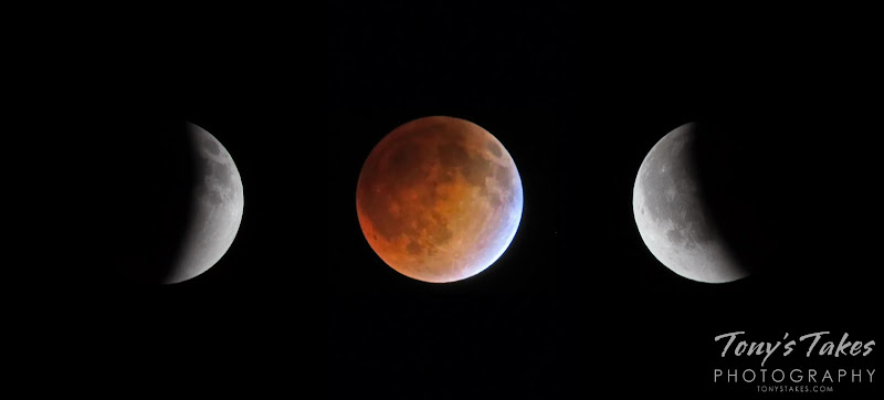
April 15, 2014 – The lunar eclipse is seen half-way to totality, the total lunar eclipse, and half-way between totality and the end. Click for a larger view. (Tony’s Takes)
During totality, the moon will be rendered orange / red as the Earth’s shadow envelops the moon. Many are calling this a ‘blood moon’ but the meaning behind that term isn’t exactly clear.
As written on EarthSky.org, some attribute it to the lunar tetrad – four successive full lunar eclipses without any partial eclipses. Tomorrow morning’s eclipse is the second in the lunar tetrad with each full lunar eclipse coming six months apart.
The blood moon as it pertains to these eclipses should not be confused with the October full moon which is also referred to as a blood moon in folklore.
With the first full month of fall here, October usually brings one of the quietest weather months in the Denver area with plenty of mild, sunny days and clear, cool nights.
October is historically the second sunniest month and conditions are generally calm.
However we also will usually see our first taste of winter during the month with the first freeze and first snowfall of the season. Temperatures as well will start to drop and by the end of the month the average nighttime lows are below freezing.
Don’t miss a thing when it comes to our ever-changing weather! Be sure to ‘like’ us on Facebook, follow us on Twitter and add us to your Google+ circles.
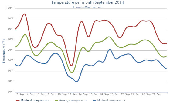
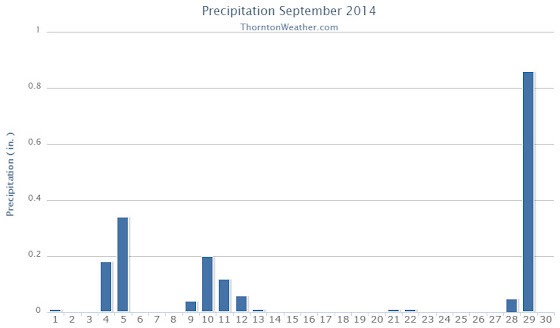
Thornton’s September this year was relatively benign and lacking much drama although it was a bit of a rollercoaster. Temperatures had their large swings and we saw a couple of days with healthy precipitation.
The month started out slightly cooler than normal on the first but then warmed over the next couple of days to a high of 93.8 degrees on the third.
Low pressure and a cold front brought an end to the heat and three days of cooler than normal temperatures arrived. Two of those three days combined to deliver more than a half inch of precipitation.
Warmer and drier weather returned for a few days before a more potent cold front pushed in. The 11th and 12th of the month brought our coldest days of the month. Low temperatures became quite chilly dropping to below freezing on the morning of the 13th as the system moved out.
Some rain fell on those days and while Denver recorded a trace of snow on the morning of the 12th, none was seen in Thornton.
We then rebounded nicely with 10 of the next 11 days seeing high temperatures above 80 degrees, many of those in the mid to upper 80s.
Things cooled down for the last three days as a strong system moved through. We recorded a significant 0.86 inches of rain on the 29th.
Thornton’s overall average temperature for the month was 62.6 degrees. This was a bit below the long term Denver average of 63.4 degrees. Out at the airport, it was as usual warmer with an average of 64.8 degrees.
Temperatures ranged from a high of 93.8 degrees on the 3rd down to a chilly low of 30.9 degrees on the 13th. Denver’s warmest day matched ours on the 3rd with a reading of 94 degrees while the Mile High City’s coldest reading of 33 degrees came on the 12th.
Denver saw one temperature record during the month. The record high minimum for September 25th was set with a reading of 56 degrees. This tied the record for the date last set in 1981.
In terms of precipitation, Thornton recorded 1.89 inches in the rain bucket for the month. Denver saw 1.79 inches. Both were well above Denver’s September average of 0.96 inches.
A daily rainfall record for Denver was set on the 29th when 1.01 inches fell at the airport. The old record of 0.96 inch for the date was set in 1959.
Thornton, Colorado’s September 2014 Temperature Summary. (ThorntonWeather.com)Thornton, Colorado’s September 2014 Precipitation Summary. (ThorntonWeather.com)
...THE DENVER CO CLIMATE SUMMARY FOR THE MONTH OF SEPTEMBER 2014...

CLIMATE NORMAL PERIOD 1981 TO 2010
CLIMATE RECORD PERIOD 1872 TO 2014

WEATHER         OBSERVED          NORMAL  DEPART  LAST YEAR`S
                 VALUE   DATE(S)  VALUE   FROM    VALUE  DATE(S)
                                          NORMAL
................................................................
TEMPERATURE (F)
RECORD
 HIGH              97   09/06/2013
                        09/05/2013
                        09/04/1995
 LOW               17   09/29/1985
HIGHEST            94   09/03        91       3       97  09/06
                                                          09/05
LOWEST             33   09/12        35      -2       38  09/28
AVG. MAXIMUM     78.9              78.5     0.4     78.6
AVG. MINIMUM     50.6              48.3     2.3     54.2
MEAN             64.8              63.4     1.4     66.4
DAYS MAX >= 90      2               3.4    -1.4        7
DAYS MAX <= 32      0               0.0     0.0        0
DAYS MIN <= 32      0               0.8    -0.8        0
DAYS MIN <= 0       0               0.0     0.0        0
PRECIPITATION (INCHES)
RECORD
  MAXIMUM         5.61   2013
  MINIMUM            T   1892                         1944
TOTALS           1.79              0.96    0.83     5.61
DAILY AVG.       0.06              0.03    0.03     0.19
DAYS >= .01         9               6.5     2.5       10
DAYS >= .10         4               3.3     0.7       10
DAYS >= .50         1               0.6     0.4        3
DAYS >= 1.00        1               0.1     0.9        2
GREATEST
 24 HR. TOTAL    1.01   09/29 TO 09/29           09/14 TO 09/15

SNOWFALL (INCHES)
RECORDS
 TOTAL             17.2   1991
TOTALS              T               1.3     -1.3       0

DEGREE_DAYS
HEATING TOTAL      91               125     -34       83
 SINCE 7/1         98               141     -43       83
COOLING TOTAL      88                76      12      133
 SINCE 1/1        701               764     -63      999

FREEZE DATES
RECORD
 EARLIEST     09/08/1962
 LATEST       06/08/2007
EARLIEST                        10/07
LATEST                          05/05
.....................................................

WIND (MPH)
AVERAGE WIND SPEED              9.4
RESULTANT WIND SPEED/DIRECTION   3/186
HIGHEST WIND SPEED/DIRECTION    33/350    DATE  09/09
HIGHEST GUST SPEED/DIRECTION    40/360    DATE  09/09

SKY COVER
POSSIBLE SUNSHINE (PERCENT)   MM
AVERAGE SKY COVER           0.50
NUMBER OF DAYS FAIR           13
NUMBER OF DAYS PC             11
NUMBER OF DAYS CLOUDY          6

AVERAGE RH (PERCENT)     55

WEATHER CONDITIONS. NUMBER OF DAYS WITH
THUNDERSTORM              3     MIXED PRECIP               0
HEAVY RAIN                1     RAIN                       6
LIGHT RAIN                9     FREEZING RAIN              0
LT FREEZING RAIN          0     HAIL                       0
HEAVY SNOW                0     SNOW                       0
LIGHT SNOW                2     SLEET                      0
FOG                       9     FOG W/VIS <= 1/4 MILE      1
HAZE                      3

-  INDICATES NEGATIVE NUMBERS.
R  INDICATES RECORD WAS SET OR TIED.
MM INDICATES DATA IS MISSING.
T  INDICATES TRACE AMOUNT.
Wildlife is still quite active along the Front Range and flowers will hold on to their petals for at least the first part of the month. Then of course there is the weather which you never know what to expect. Thunderstorms, heavy rain, and even snow are a possibility.
Slideshow updated October 1, 2014
To learn more about how to send your photo to us for inclusion in the slideshow, see below the slideshow.
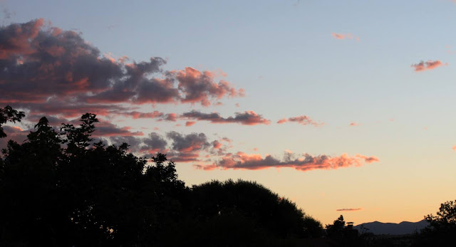
Showcasing images captured by ThorntonWeather.com readers as well as some of our own, our monthly slideshow covers the entire gamut of weather-related imagery.
Sunsets, sunrises, wildlife and of course every type of weather condition are vividly depicted in images captured from yours and our cameras.
Click the play button below and sit back and enjoy the images.
What is missing in the slideshow above? Your photo!
Our monthly photo slideshow is going to feature images that we have taken but more importantly images that you have captured. The photos can be of anything even remotely weather-related.
Landscapes, current conditions, wildlife, pets, kids. Whimsical, newsy, artsy. Taken at the zoo, some other area attraction, a local park, a national park or your backyard. You name it, we want to see and share it!
Images can be taken in Thornton, Denver or anywhere across the extraordinary Centennial State. We’ll even take some from out of state if we can tie it to Colorado somehow.
We’ll keep the criteria very open to interpretation with just about any image eligible to be shown in our slideshows.
What do you win for having your image in our slideshow? We are just a ‘mom and pop’ outfit and make no money from our site so we really don’t have the means to provide prizes. However you will have our undying gratitude and the satisfaction that your images are shared on the most popular website in Thornton.
To share you images with us and get them included in the slideshow just email them to us or share them with ThorntonWeather.com on any of the various social media outlets. Links are provided below.
Sprinkles vs rain: Toddlers debate the weighty issue. (YouTube / Tara Willmott)
Certainly politics, religion and even climate change are hotly debated topics but as a video shows, toddlers can get pretty fired up about whether it is sprinkling or raining.
Posted to YouTube yesterday, the video portrays how quickly a discussion about the weather can get heated.
A young boy insists it is just sprinkling – because his mom told him it was – while two twin girls demand it is raining.
Strong words are exchanged and soon some poking ensues. The boy learns a harsh lesson about disagreeing with girls as one ‘pokes his heart’ and brings him to tears.
Like many debates likely conducted by these toddlers’ parents, in the end everyone insists they are right and no minds seem to be changed. 😉
The leaves in the high country are changing and certainly give meaning to the moniker ‘Colorful Colorado.’ (ThorntonWeather.com)
This time of year many folks head to the hills west of Denver in search of gold – fall foliage gold.
This year the changing of the colors seems to be occurring a bit earlier than normal and the last half of September should provide some great opportunities.
Where to go? Below are five of ThorntonWeather.com’s favorite ones near Denver. After that, we will tell you where you can find a great website that provides regular updates on viewing conditions.
I-70 Corridor – If you’re looking for the easiest route, then this one is for you. Simply head west on I-70 about 110 miles to Avon. Between Vail and Avon, both sides of I-70 are lined beautifully with aspen.
Rocky Mountain National Park – One of the most popular summer destinations in the state is of course also a prime spot to view aspen in all their glory. Once in the park on Trail Ridge Road, head toward Bear Lake. Glacier Gorge Junction provides a beautiful spot and you of course also get to enjoy all the splendor that Rocky Mountain National Park has to offer.
Peak to Peak Highway – This little road trip can be a dual purpose trip – gambling and fall foliage viewing! Take U.S. 6 through Clear Creek Canyon and then 119 through Blackhawk and Central Center. You can of course stop there if your wallet is fat enough and donate some money to the casinos. From there continue on 119 toward Nederland. Take highway 72 toward Ward and Allenspark. There you will find more golden aspen than you can imagine, all with the Continental Divide nearby.
Poudre Valley Canyon – Heading north on I-25 take Colorado 14 west and into Poudre Canyon and Roosevelt National Forest. As you continue west you will come very near timberline as you come to Cameron Pass. Amazing views abound!
Guanella Pass – This is a nice, relatively short drive from Denver. From C470 take 85 through Bailey and Conifer, a nice drive unto itself. When you come to the town of Grant, take the Guanella Pass Scenic and Historic Byway north to Georgetown. The air is pretty thin along the way as you climb in excess of 11,500 views through the Pike and Arapahoe National Forests. Fair warning – about 10 miles of the road is gravel but it is well maintained.
A couple other possibilities further from the Front Range:
Leadville / Aspen – From Denver take I-70 west to Copper Mountain and then Colorado 91 south over Freemont Pass to Leadville. Along the way there are plenty of viewing opportunities and Leadville is a nice little town to make a stop. From here you can take Highway 24 north back through Minturn and Vail. To extend the drive, take Highway 24 south to Colorado 82 and head toward Aspen. You can stop by the Maroon Bells in White River National Forest to view some of the most photographed mountains in Colorado.
Cottonwood Pass – From Denver take Highway 285 to Buena Vista. Head west on Main Street for seven miles then west on County Road 344 / Colorado 82. From there you start the climb up Cottonwood Pass with absolutely stunning views from the top. If you are up for it, you can continue down the west side of the pass into the Taylor Park area. Be forewarned though that the western half of the pass is unpaved and twisty.
If you do head out, be sure to send us your pictures for inclusion in our monthly photo slideshows!
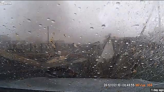
Screen capture of video showing the aftermath of a tornado in Russia. (LiveLeak)
An amazing tornado video captured by a dash mounted camera was released on YouTube recently. Apparently taken in Russia on August 29, a surprised driver pulls out of his garage to discover a tornado ripping through the area.
The video begins with the driver backing out of the driveway in heavy rain. As the vehicle turns to face down the road, trees are being pummeled by strong winds and debris from other houses and nearby buildings flies through the air.
After sitting for a scant few seconds – likely struggling to comprehend Mother Nature’s fury that is erupting around him – the driver tries to go back to his garage. As he turns back, the garage collapses before his eyes.
Video added at the end shows extensive damage to cars and homes in the area.
It is believed the video is of an EF-3 rated twister that tore a 28 mile path through Kariyevo.
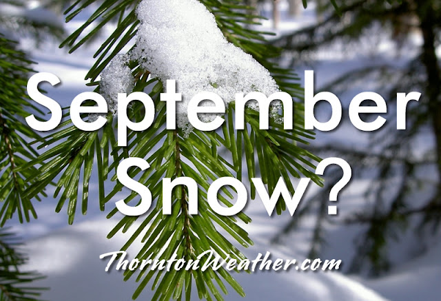
September snow in Denver? Possible and not at all unusual.
With a significant blast of cold air set to arrive this week, there is a chance for the Mile High City to see its first snowfall of the season. While such an event would be the first September snow of this millennium, it would hardly be unusual.
Looking back at Denver’s snowfall records dating to 1882, 45 Septembers have recorded a trace or more of snowfall. That means that out of 132 Septembers including this one, roughly one third of them have seen snow. Overall, the month averages 1.1 inches.
Of those 45 Septembers with snow, 17 were for only a trace. Twenty eight, or roughly 21 percent, had measurable snowfall of 0.1” or more.
Denver’s heaviest 24 hour September snowfall came between September 24 and 25 in 1936 when a hefty 15.0 inches fell to the ground. That snowfall contributed to 1936 taking its place as the second snowiest September on record.
For the entire month of September, some years saw rather significant totals. The top 10 September snowfall totals include:
17.2 inches in 1971
16.5 inches in 1936
12.9 inches in 1959
11.4 inches in 1895
8.7 inches in 1985
7.4 inches in 1995
6.5 inches in 1908
5.8 inches in 1961
5.5 inches in 1965
5.4 inches in 1993
The earliest snowfall on record occurred on September 3, 1961. On that date 4 inches of snowfall fell at the old Stapleton International Airport and the mercury dropped to a low of 33 degrees.
The last time Denver saw a September snow was on September 23, 2000 when 0.2 inches was recorded.
On average, we receive our first snow on October 19 so should snow fall, it will be well ahead of normal.
The cold that looks to come could very well bring an end to the growing season. The Mile High City’s first frost on average comes on September 20th followed by the average first freeze on October 7. Given that, a frost at the current time of the month is not that far off the mark. It does not appear at this moment we will see that first freeze – yet – but a frost is possible.
 Forecasts held true and our unseasonably warm weather pushed the mercury into record-setting territory today.
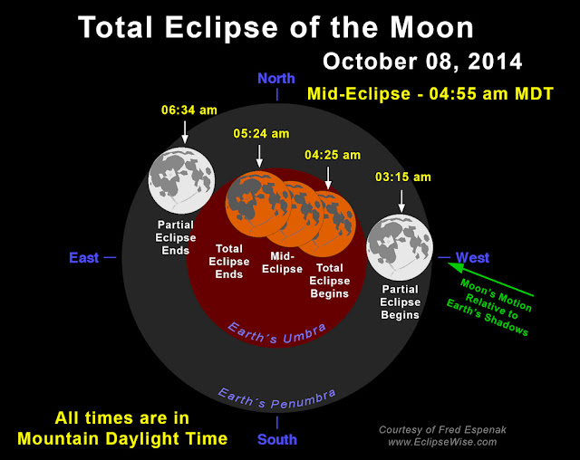
 With the first full month of fall here, October usually brings one of the quietest weather months in the Denver area with plenty of mild, sunny days and clear, cool nights.